
Recommandé
Contenu connexe
Tendances
Tendances (20)
En vedette
En vedette (14)
Similaire à El niño, explained a guide to the biggest weather story of 2015 vox
Similaire à El niño, explained a guide to the biggest weather story of 2015 vox (20)
Plus de zubeditufail
Plus de zubeditufail (20)
Dernier
Dernier (20)
El niño, explained a guide to the biggest weather story of 2015 vox
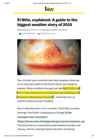
- 1. 12/7/2015 El Niño, explained: A guide to the biggest weather story of 2015 Vox http://www.vox.com/2015/8/17/9164499/elnino2015 1/22 El Niño, explained: A guide to the biggest weather story of 2015 Updated by Brad Plumer on November 19, 2015, 1:26 p.m. ET @bradplumer brad@vox.com Over the past year, scientists have been keeping a close eye on an important swath of the Pacific Ocean, just along the equator. When conditions here get just right, an El Niño can form — wreaking havoc on weather patterns across the globe. Now it looks like we're in for a monster. The El Niño currently brewing in the Pacific is shaping up to be one of the strongest ever recorded ( https://www.wmo.int/pages/prog/wcp/wcasp/enso_update_latest This phenomenon is expected to peak between October and January, with far-reaching impacts all winter and spring. ( http://www.vox.com/cards/el-nino-2014/why-is- everyone-talking-about-el-nino)
- 2. 12/7/2015 El Niño, explained: A guide to the biggest weather story of 2015 Vox http://www.vox.com/2015/8/17/9164499/elnino2015 2/22 Based on past experience, El Niño could potentially bring much-needed rain to California, but also drought in Australia, destructive floods in Peru, and so on. El Niño has already helped make 2015 the hottest year on record ( http://www.vox.com/2015/10/22/9591986/2015- september-record-temperatures) — and might well do the same for 2016. That said, El Niño events are often unpredictable and full of surprises. So what follows is a guide to how El Niño works, what we know about the 2015 event, and how a potentially massive El Niño could upend the world's weather over the coming months. A very basic definition of El Niño El Niño is a weather phenomenon that occurs irregularly in the eastern tropical Pacific every two to seven years. When the trade winds that usually blow from east to west weaken, sea surface temperatures start rising, setting off a chain of atmospheric impacts. ( http://www.vox.com/cards/el-nino- 2014/why-is-everyone-talking-about-el-nino) El Niños can be strong or weak. Strong events can temporarily disrupt weather patterns ( http://www.pmel.noaa.gov/tao/elnino/impacts.html) around the world, typically making certain regions wetter (Peru or California, say) and others drier (Southeast Asia). Some countries suffer major damage as a result. El Niños also transfer heat stored in the deeper layers of the ocean to the surface. When combined with global
- 3. 12/7/2015 El Niño, explained: A guide to the biggest weather story of 2015 Vox http://www.vox.com/2015/8/17/9164499/elnino2015 3/22 Why this year's El Niño is a huge deal The last truly massive El Niño appeared in 1997-'98 ( https://en.wikipedia.org/wiki/1997%E2%80%931998_El_Ni%C3%B and ended up causing an estimated $35 billion in destruction and 23,000 deaths around the world. (It also inspired that famous Chris Farley sketch ( https://www.youtube.com/watch?v=IvmeUStFvz8).) Now we're on the verge of a similarly massive event: Late-October status of the 1997 and 2015 El NIño events in terms of satellite-derived data showing departure from average sea surface height for a given time of year, which is correlated with warmth in the upper ocean. (NASA/JPL ( http://sealevel.jpl.nasa.gov/elnino2015/1997vs2015-latest-still.jpg)) That, in itself, is a surprise. Back in March, NOAA's Climate Prediction Center announced that a weak El Niño had warming, that can lead to record hot years, as in 1998. "El Niño" got its name ( http://faculty.washington.edu/kessler/occasionally- asked-questions.html#q2) in the 1800s from Peruvian fisherman, who first noticed a mysterious warm current that would appear around Christmas. They called it the "little boy" or "Christ child."
- 4. 12/7/2015 El Niño, explained: A guide to the biggest weather story of 2015 Vox http://www.vox.com/2015/8/17/9164499/elnino2015 4/22 formed ( http://www.vox.com/2015/3/6/8161511/el-nino- weak-2015) in the Pacific, but many experts initially thought it might fizzle out by summer. Instead, this El Niño kept strengthening, with ocean temperatures in the eastern tropical Pacific continuing to soar. By mid-November, temperatures in one critical part of the ocean, the Niño 3.4 region, were running even hotter ( https://twitter.com/ggweather/status/666281247698583552/phot than they were in 1997: (Jan Null ( https://twitter.com/ggweather/status/666281247698583552/photo/1)) "Right now we say we think it's really going to be one of the three strongest ones," said Michel Jarraud, the secretary general of the World Meteorological Organization, who compared it with the 1997-98, 1982-83, and 1972-73 El Niño events. "It may be one of the two; that we don't know yet. But definitely it's already a very strong one."
- 5. 12/7/2015 El Niño, explained: A guide to the biggest weather story of 2015 Vox http://www.vox.com/2015/8/17/9164499/elnino2015 5/22 Countries across the globe will have to brace themselves as this event peaks this winter and lasts through the spring. El Niño has already triggered longer droughts in Indonesia, enabling massive man-made peatland fires ( http://www.vox.com/2015/10/30/9645448/indonesia- fires-peat-palm-oil) to rage out of control, creating toxic haze that has spread as far as Singapore. Warmer ocean temperatures have also caused a major coral bleaching event ( http://www.noaanews.noaa.gov/stories2015/100815- noaa-declares-third-ever-global-coral-bleaching- event.html), harming reefs around the world. And El Niño may just be getting started: In the past, major events have brought unusually hot, dry weather to Australia that can cramp wheat yields and amp up wildfires. It can bring hotter, drier weather to India that hurts agriculture. It can bring heavy rain and destructive flooding to Peru, washing away houses and spreading cholera. That said, El Niño isn't all bad. In the United States, it could bring some needed rain ( http://www.nytimes.com/2015/08/14/science/signs- of-a-historic-el-nino-but-forecasters-remain- wary.html?partner=rss&emc=rss&smid=tw- nytimesscience&_r=0) this winter to ease California's drought (though also deadly mudslides and flooding). Historically, El Niño has also served up milder US winters and tamped down on Atlantic hurricanes. One important caveat, however, is that every El Niño unfolds a bit differently — and some have unexpected impacts. As
- 6. 12/7/2015 El Niño, explained: A guide to the biggest weather story of 2015 Vox http://www.vox.com/2015/8/17/9164499/elnino2015 6/22 NOAA's Emily Becker points out ( https://www.climate.gov/news- features/blogs/enso/august-2015-el-ni%C3%B1o- update-supercalifragilisticexpealidocious), strong El Niño events usually bring rain to California in the winter (as in 1982-'83), but occasionally they don't (as in 1965-'66): Another key story to watch is how a strong El Niño might push up temperatures worldwide. Global average temperatures are already going up over time, thanks to all the carbon dioxide we're adding to the atmosphere. According to NASA, 2014 was the hottest year on record. But there was no El Niño that year — and El Niño years tend to be a bit hotter than average , as heat gets transferred from the ocean to the surface. The combination of El Niño and rising CO2 is already helping 2015 shatter heat records ( http://www.vox.com/2015/10/22/9591986/2015- (NOAA Climate Prediction Center ( https://www.climate.gov/news- features/blogs/enso/august-2015-el-ni%C3%B1o-update- supercalifragilisticexpealidocious)) ( http://www.vox.com/cards/el-nino-2014/el-nino-and- global-warming)
- 7. 12/7/2015 El Niño, explained: A guide to the biggest weather story of 2015 Vox http://www.vox.com/2015/8/17/9164499/elnino2015 7/22 september-record-temperatures). The big question now is whether it'll do the same for 2016: Bottom line: There are still a lot of question marks about how this will unfold. But El Niño could well be the biggest weather story of the next six months, with ripple effects around the globe. How El Niño actually works, step by step To see how El Niño works, it helps to understand what the equatorial Pacific looks like under normal, or "neutral," conditions: 1) Neutral conditions in the equatorial Pacific Ocean Normally, the tropical Pacific features strong trade winds that blow warm ocean water from east to west, where it piles up near Indonesia. Meanwhile, back east along South America, frigid water deep down in the ocean gets pulled up closer to the surface, cooling the area around Peru. Here's a diagram: (NOAA)
- 8. 12/7/2015 El Niño, explained: A guide to the biggest weather story of 2015 Vox http://www.vox.com/2015/8/17/9164499/elnino2015 8/22 As a result, during "neutral" conditions, sea levels are about half a meter higher near Indonesia than they are in Peru. And the surface water near Indonesia is about 8°C warmer (14.4°F) than it is near Peru. That temperature difference creates a convective loop in the atmosphere that, in turn, reinforces the trade winds. This ends up affecting a lot more than just this stretch of ocean. Because the Pacific is so vast, this system is a major driving force in the global climate. The large, warm pool of water near Indonesia causes the air above it to rise, creating rainfall in the region. And this system shapes the jet streams that guide weather and storms around the world. That's how it works under normal conditions, anyway. But things look a little different when El Niño comes along. 2) Now along comes El Niño Every few years, those prevailing Pacific trade winds that blow east to west can weaken. (Scientists are still debating ( http://faculty.washington.edu/kessler/occasionally- asked-questions.html#q1) the nuances of exactly why (William Kessler/NOAA/PMEL)
- 9. 12/7/2015 El Niño, explained: A guide to the biggest weather story of 2015 Vox http://www.vox.com/2015/8/17/9164499/elnino2015 9/22 this happens.) When the trade winds weaken, all that warm water that was piled up near Indonesia starts sloshing back eastward, pulled back down by gravity. What's more, the underwater layer known as the thermocline ( http://en.wikipedia.org/wiki/Thermocline) starts sinking. As a result, there's less cold water rising up from the deep ocean near South America — so the waters near Peru start warming up. Here's another diagram: This causes sea surface temperatures in the east and central Pacific to start rising and the trade winds to weaken even further. What's more, rainfall starts following that warm pool of water as it travels eastward. That's why El Niño is usually associated with drier weather in places like Indonesia and Australia, as well as heavier rains in places like Peru (or California). The rain is essentially moving east. Scientists officially declare an El Niño ( http://www.climate.gov/news- features/blogs/enso/how-will-we-know-when-el- ni%C3%B1o-has-arrived) when sea surface (William Kessler/NOAA/PMEL)
- 10. 12/7/2015 El Niño, explained: A guide to the biggest weather story of 2015 Vox http://www.vox.com/2015/8/17/9164499/elnino2015 10/22 temperatures in the equatorial Pacific Ocean (known as the Niño 3.4 region ( http://www.ncdc.noaa.gov/teleconnections/enso/indicators/sst.ph rise 0.5°C above their historical baseline for three months in a row — and once atmospheric conditions and rainfall patterns shift accordingly. Again, because the Pacific is so vast, an El Niño can have large ripple effects ( http://www.pmel.noaa.gov/tao/elnino/impacts.html) on weather around the world, especially during the winter months. Here's a look at the changes that have historically accompanied El Niño events: Typical effects of an El Niño during the winter: A strong El Niño can weaken monsoons in the Indian Ocean, for example. It can also cause the jet stream to start stretching ( https://www.nc- climate.ncsu.edu/edu/k12/.el_nino) from the Eastern Pacific across the southern United States, bringing rainfall (NOAA)
- 11. 12/7/2015 El Niño, explained: A guide to the biggest weather story of 2015 Vox http://www.vox.com/2015/8/17/9164499/elnino2015 11/22 and storms with it. Still, a lot depends on how strong the El Niño actually is — and occasionally there are aberrations and exceptions to the rule. More on that below. El Niño's return in 2015 — and why scientists have been talking about a "Godzilla" event Ever since early 2014, scientists have been expecting this latest El Niño to form. But, in a sign of how slippery the system can be, El Niño kept defying predictions ( http://www.vox.com/2014/11/8/7177709/el-nino- 2014-forecast-weakening) and not showing up. Finally, in March 2015, after several false starts, scientists at NOAA's climate prediction center were ready ( http://www.climate.gov/news- features/blogs/enso/march-2015-enso-discussion- el-ni%C3%B1o-here) to declare that a weak El Niño was underway. Specifically, sea surface temperatures in that Niño 3.4 region ( http://www.ncdc.noaa.gov/teleconnections/enso/indicators/sst.ph (roughly in the center of the chart below) had been at least 0.5°C above their baseline since September. And, importantly, atmospheric conditions were responding in turn, with more rain over the central Pacific and less rain over Indonesia: ( http://www.vox.com/cards/el-nino-2014/will-we-get- strong-el-nino)
- 12. 12/7/2015 El Niño, explained: A guide to the biggest weather story of 2015 Vox http://www.vox.com/2015/8/17/9164499/elnino2015 12/22 At the time, however, NOAA's forecasters said ( http://www.climate.gov/news- features/blogs/enso/march-2015-enso-discussion- el-ni%C3%B1o-here) that this El Niño looked "weak," with possibly minimal effects on global weather patterns, and only had a 50 to 60 percent chance of lasting through the summer. Then, somewhat unexpectedly, El Niño kept getting stronger and stronger. And stronger. By October 2015, sea surface temperatures had soared to more than 2°C above baseline ( https://www.climate.gov/news- features/blogs/enso/november-el-ni%C3%B1o- update-it%E2%80%99s-small-world) in the Niño 3.4 region, and scientists were seeing strong telltale atmospheric changes. Notice how the anomalous warm area has moved east and is much, much warmer than usual: Sea surface temperature departures from average (based on 1981–2010) at the end of February 2015. NOAA map by Emily Becker, Climate Prediction Center.
- 13. 12/7/2015 El Niño, explained: A guide to the biggest weather story of 2015 Vox http://www.vox.com/2015/8/17/9164499/elnino2015 13/22 Forecasters now expect ( https://www.wmo.int/pages/prog/wcp/wcasp/enso_update_latest this El Niño to peak between October and January, and when it does, it's likely to rank among the two or three strongest ever record (along with 1997-'98, 1982-'83, and 1972-'73.) Some forecasters have even dubbed this one ( http://www.washingtonpost.com/blogs/capital- weather-gang/wp/2015/08/14/godzilla-el-nino- meteorologists-need-to-back-off-their-criticism-of- apt-moniker/) a potential "Godzilla." We're already started to see ( https://www.wmo.int/media/content/el- ni%C3%B1o-expected-strengthen-further-high- impacts-unprecedented-preparation) some major El Niño impacts around the world. A paucity of rainfall in Indonesia this fall allowed manmade forest and peat fires to rage out of control ( http://www.vox.com/2015/10/30/9645448/indonesia- fires-peat-palm-oil), choking the region in a thick toxic haze. And the warmer Pacific waters have fostered an Average sea surface temperature departure from the 1981-2010 average over the four weeks ending on November 7. Graphic by climate.gov, data from NCEP-NCAR reanalysis. ( ( https://www.climate.gov/news-features/blogs/enso/november-el-ni%C3%B1o- update-</cite>%0A%0A</figure>%0A</div>)
- 14. 12/7/2015 El Niño, explained: A guide to the biggest weather story of 2015 Vox http://www.vox.com/2015/8/17/9164499/elnino2015 14/22 unusually active tropical cyclone season, a hallmark of El Niño. On the flip side, however, the event has also fostered more wind shear in the Atlantic that has curtailed hurricane activity there. El Niño could bring rain to California — but may not end the drought As noted above, El Niño tends to be associated with changes in weather patterns around the world, especially during the Northern Hemisphere winter. One tantalizing possibility is that a strong El Niño will bring more rain to California, alleviating the state's drought. But even here, nothing is certain. El Niño only affects US weather indirectly, by altering atmospheric circulation and shifting the North Pacific jet stream. (See here ( https://www.climate.gov/news- features/blogs/enso/how-enso-leads-cascade- global-impacts) for a lucid explanation by Columbia University's Anthony Barnston.) This is an intricate chain of events, and small kinks at certain points can affect the ultimate outcome. As such, Becker cautions people ( https://www.climate.gov/news- features/blogs/enso/august-2015-el-ni%C3%B1o- update-supercalifragilisticexpealidocious) to think not in terms of certainties but in terms of probabilities. Here's an example of how El Niño might shift the odds of a wetter- than-average winter for California (she notes that this isn't a prediction, just an illustration):
- 15. 12/7/2015 El Niño, explained: A guide to the biggest weather story of 2015 Vox http://www.vox.com/2015/8/17/9164499/elnino2015 15/22 In other words, thanks to El Niño, California has a greater chance of a wetter winter, but not a 100 percent chance. What's more, even if rain does come, that may not be enough to completely erase the massive water deficit that California has built up over the past five years. The state likely needs record precipitation ( http://www.vox.com/2015/1/13/7538163/california- drought-rainfall) to end the drought, and it also needs the right mix of rain (to recharge the reservoirs) and snow in the Sierra Nevada mountains (to melt during the spring and summer). Also, be warned: Heavy rain after a drought can bring floods and mudslides. Southern California got a possible preview ( http://www.latimes.com/local/california/la-me- mud-climate-20151017-story.html) in mid-October, when a short burst of intense rains led to major mudflows that trapped hundreds of cars. So people need to be ready. El Niño tends to hurt some countries and benefit others An example of how a strong El Niño could shift the odds for the amount of seasonal precipitation. Official outlooks from the Climate Prediction Center are available here ( http://www.cpc.ncep.noaa.gov/products/predictions/90day/).
- 16. 12/7/2015 El Niño, explained: A guide to the biggest weather story of 2015 Vox http://www.vox.com/2015/8/17/9164499/elnino2015 16/22 others It's not quite right to say that El Niño events are "bad" or "good." They tend to have different impacts on different regions. One recent study ( http://www.econ.cam.ac.uk/people/cto/km418/GVAR_El_Nino.pdf from the University of Cambridge found that on average, El Niño events hurt economic activity in Australia, Chile, Indonesia, India, Japan, New Zealand, and South Africa. The reasons varied: drought and reduced crop yields in Australia and India, forest fires in Indonesia, less productive fisheries in Peru. But that study also found that on average, El Niño tended to boost the economies in Argentina, Canada, Mexico, and even the United States, at least in the very short term. Again, many factors were at play: In addition to bringing needed rain to California and Texas, El Niño was associated with less tornado activity in the midwestern United States and fewer hurricanes in the Atlantic Ocean. Here's a table of the estimated economic impacts on a broad selection of countries:
- 17. 12/7/2015 El Niño, explained: A guide to the biggest weather story of 2015 Vox http://www.vox.com/2015/8/17/9164499/elnino2015 17/22 Again, every big El Niño is different and has its own idiosyncrasies. So think of this table as more a rough guide than gospel. There are also two important twists here. As the WMO's Michel Jarraud stressed ( https://www.wmo.int/media/content/el- ni%C3%B1o-expected-strengthen-further-high- impacts-unprecedented-preparation) in his October news conference, many countries have learned from the past and implemented measures to guard against El Niño's impacts. (Mexico, for instance, was well-prepared ( http://www.vox.com/2015/10/26/9615274/hurricane- patricia-aftermath) for a record-strength Pacific hurricane that hit the state last month.) Conversely, this El Niño is also playing out in the context of record warm ocean temperatures, so it could have unpredictable impacts. "Our scientific understanding of El (Cashin et al, 2014 ( http://www.econ.cam.ac.uk/people/cto/km418/GVAR_El_Nino.pdf))
- 18. 12/7/2015 El Niño, explained: A guide to the biggest weather story of 2015 Vox http://www.vox.com/2015/8/17/9164499/elnino2015 18/22 Niño has increased greatly in recent years. However, this event is playing out in uncharted territory," said Jarraud. "This naturally occurring El Niño event and human induced climate change may interact and modify each other in ways which we have never before experienced." El Niño is helping make 2015 a record hot year. What about 2016? Thanks to global warming , the Earth's average surface temperature has been going up over time. But there's a lot of variation from year to year. El Niño years tend to be a bit hotter than average. La Niña years (when those trade winds strengthen rather than weaken) tend to be a bit cooler than average. Like so: What's going on here? As humans load more greenhouse gases into the atmosphere, we're trapping more and more heat on the Earth's surface. But more than 90 percent of that extra heat ( http://www.giss.nasa.gov/research/briefs/hansen_16/) is absorbed by the oceans. So subtle interactions between the ocean and the atmosphere can make a big difference for surface temperatures. ( http://www.vox.com/cards/global-warming/what-is- global-warming) (NASA ( http://earthobservatory.nasa.gov/NaturalHazards/view.php? id=85083&utm_content=buffer16162&utm_medium=social&utm_source=twitter.com&utm_campaign=buf TWEET SHARE
- 19. 12/7/2015 El Niño, explained: A guide to the biggest weather story of 2015 Vox http://www.vox.com/2015/8/17/9164499/elnino2015 19/22 When conditions in the Pacific are neutral, more of that heat is trapped beneath the ocean surface. When a strong El Niño forms, more of that heat is transferred to the surface. That's why the Earth's average surface temperatures reached new highs in 1998: You had the combination of global warming and an extremely strong El Niño. What was remarkable about 2014 is that it was likely the hottest year on record ( http://www.vox.com/2015/1/16/7556423/2014- hottest-year) even without an El Niño event — a sign that Earth keeps getting warmer overall. Meanwhile, 2015 is basically guaranteed to be even hotter ( http://thinkprogress.org/climate/2015/08/14/3691940/hottest- july-hottest-year-record/) than 2014. Now throw a monster El Niño into the mix, and we're looking at a potential shattering of records. Back in January, NASA's Gavin Schmidt explained ( http://www.vox.com/2015/1/16/7556423/2014- hottest-year) at a press conference that temperatures typically peak about three months after an El Niño event. Given that forecasters expect this current El Niño to last until next spring, it's entirely possible we could see 2016 also set new highs. We'll have to wait and see. Further reading: NOAA's ENSO blog ( http://www.climate.gov/news- features/department/enso-blog) is a terrific source of information for updates on El Niño. Weather
- 20. 12/7/2015 El Niño, explained: A guide to the biggest weather story of 2015 Vox http://www.vox.com/2015/8/17/9164499/elnino2015 20/22 Underground also posts ( http://www.wunderground.com/blog/JeffMasters/comment.htm entrynum=3071) frequent insightful updates. It's also worth reading this piece ( https://www.climate.gov/news- features/blogs/enso/challenges-enso- today%E2%80%99s-climate-models) by Eric Guilyardi, of the University of Reading, on the challenges that forecasters have in modeling ENSO, the Pacific Ocean system of which El Niño is a part. "Until we understand more, we may have to come to terms that, for the foreseeable future, ENSO may not be reliably predicted more than a few months in advance," he writes.
- 21. 12/7/2015 El Niño, explained: A guide to the biggest weather story of 2015 Vox http://www.vox.com/2015/8/17/9164499/elnino2015 21/22 Was this article helpful? ( http://www.vox.com/cards/el-nino-2014/how-might-el-nino-affect- the-united-states) El Niño, explained How could El Niño affect the United States? El Niño tends to affect the tropical areas in the Pacific first, while its impacts on the United States usually aren't felt until the winter. That's because El Niño affects the jet stream, which mainly affects winter weather in the US. Next Up How gun control works in America, compared with 4 other rich countries America's gun problem, explained 7 surprising things everyone should know about Hanukkah San Bernardino shooting: what we know
- 22. 12/7/2015 El Niño, explained: A guide to the biggest weather story of 2015 Vox http://www.vox.com/2015/8/17/9164499/elnino2015 22/22 Powered by for you You May Also Like Learn more The Weeds: Retirement age, terrorism, and C-sections Vox Sentences: Global climate talks are starting in Paris. Here's what to expect. The Walking Dead’s new trailer: Negan’s coming Facebook® Account Sign Up. Join for Free Today! Facebook Sponsored This is the most important survey in America, but it keeps getting defunded Senate takes initial steps to defund Planned Parenthood