Micro-Scholarship, What it is, How can it help me.pdf
Currituck National Estuarine Research Reserve virtual field trip
1. Currituck virtual field trip
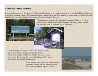
Remote and untouched by development, the Currituck Banks site is an excellent example of an undisturbed barrier island and
low-salinity estuarine system. Ten miles south of the Virginia border and three-quarters of a mile north of Corolla, this site is
bound on the east by the Atlantic Ocean and the Currituck Sound to the west.
The easiest access point is the visitor parking area off highway 12. Here
you will find a handicap accessible boardwalk that allows access through
the maritime forest to the sound side of the reserve.
Currituck Banks is comprised of 954 acres of beach, dunes,
upland shrub forest, marsh and sound. The Nature
Conservancy and the US Fish and Wildlife Service own tracts
to the north. These three sites combined make up 5,000+-acres
that are used for research and education.
If you are able to access the site from the beach
side of the reserve, you will notice that there
are no roads, but plenty signs of vehicles.
2. Access to homes north of the site are by way of the ocean side
beach. There is no through traffic to Virginia, although the
small town of Corova sits just south of the North
Carolina/Virginia border and can only be accessed by the beach
corridor.
On the ocean side a dune system exists that is only disturbed by
natural residents, such as fox, deer and rabbits, and the ever-
active wind. There is a small herd of feral horses that roam the
area. Currituck Banks NERR is the southernmost boundary that
these horses can roam free.
(looking south at Currituck and the Currituck lighthouse)
Back off the beach past dunes and shrub thickets, an
elevated boardwalk allows access through the maritime
forest. The woods here are considered maritime forest
because of their close proximity to the ocean and the
presence of some flora that is somewhat salt tolerant,
such as the wax myrtle (Myrica cerifera) seen here.
3. The fence that you see in this area is to keep the local feral herd
of horses north – keeping them away from the danger of traffic.
You may or may not see them while you are here – don’t count
on it, as they are a small population and have a large area to
roam.
As you begin your walk, you will notice to the left of the
boardwalk an unusual trashcan. This was designed to prevent
wildlife from getting into the trash – nor can they move the
can. There are plenty of raccoons in the area, and hopefully
this will keep them out.
As you look around, you will notice lots of live oak (Quercus
virginiana) trees – short oaks that are very twisted and not
very tall. This is one of the most common trees in many of
the maritime forest areas in North Carolina. This tree is
evergreen and survives the salty sea wind by its thick leathery
leaves. Typically the live oak branches form a windswept
shape. If you look, you can often see that the trees are shorter
on the ocean facing side and taller, more extensive on the side
away from the sea wind. This is caused by the prevalent
strong winter winds blowing from the northeast.
As you walk along the boardwalk, one thing you may notice
is that there are plenty of insects here! Depending on the time
of year that you visit, you may find that bug spray is helpful.
Summer is a favorite time to see lots of dragonflies.
4. Continuing through the woods you will notice high areas and low areas; these are old dune ridges. These ridges were formed
long ago. Over time, as this part of the barrier island shifted, dunes formed in front of the older dunes and eventually they
were distanced from the constantly moving sand/wind area that once formed them. Slowly larger plants and bushes, and
eventually trees grew on these old dunes, changing this from a dune habitat to a maritime forest habitat.
Now that these areas of maritime forest are somewhat protected from salt spray by the live oak trees located seaward, there
are many more animals that use these areas, including several species of woodpeckers, white-tail deer, and rabbit.
As you make your trek through the forest,
notice the colorful interpretive signs along
the way, highlighting the plant communities,
wildlife and secrets of Currituck Banks.
About half way down the boardwalk, you
will notice a primitive trail leading into the
maritime forest. Follow the 1 ½ mile out and
back trail through pine forests and live oaks
as you make your way to a view of the
Currituck Sound. Take a rest on benches
along the trail as you listen to nature’s
sounds.
5. As you move further away from the beach, you will notice there are taller pine trees, protected from strong winds, and then
you will walk through an area that is very wet. This marshy area contains a stand of red maples.
The red maple (Acer rubrum)-dominated lowland area within the Currituck Banks Reserve is an example of maritime swamp
forest, a community type considered "very rare" by the North Carolina Natural Heritage Program (Schafale and Weakley,
1990; page 243)*. They further note: "Extensive young Acer-Nyssa forests on the sound side of Currituck Banks may be
developing since the adjacent marshes turned from brackish to fresh with the closing of inlets in the banks."
The red maples found there are taxonomically the same as those elsewhere; this species varies widely in habitats throughout
the state. The swamp forest is non-tidal and includes other trees (e.g., swamp black gum, sweetgum), shrubs (e.g., wax
myrtle, red bay, cane), vines (e.g., poison ivy, Muscadine grape) and herbs (e.g., royal fern, netted chain fern, lizard's tail,
sedges). Soils are mucky, underlain by wet sands that are seasonally to intermittently-flooded or saturated.
Schafale, M.P. and A.S. Weakly. 1990. Classification of the natural communities of North Carolina: third approximation.
DENHR/Div. of Parks and Rec./N.C. Nat. Heritatge Program. Raleigh
6. Continuing on the walkway………..
There is a wealth of plant and
animal life here, much of
which goes easily unnoticed.
Some of the shrubs and vines
bear fruit that provide food for
many of the birds and
mammals that inhabit this
area. You may see catbrier
vines, as well as wild grape
vines as you walk along the
boardwalk.
At the Currituck Banks site, brackish marshes fringe the edge of the sound -“brackish”, meaning a mix of fresh and salt
water. The nearest source of salt water is Oregon Inlet in Dare County, 45 miles to the south. Currituck Sound receives
freshwater from a number of creeks draining the mainland, plus irregular amounts of salt water from the inlet. The
resulting sound water is classified as brackish, rarely exceeding two parts of salt per thousand parts of water, compared
with 35 parts per thousand in ocean water.
These waters are not influenced by regular lunar tides but by wind. This creates considerably different influences than
those described under the tidal and supratidal marshes.
Dense colonies of giant cord grass (Spartina cynosuroides), spike rush (Eleocharis obtusa), black needle rush and cattail
(Typha spp.) dominate the Currituck marshes. Others marsh species include duck potato (Sagittaria falcate), sabatia,
(Sabitia dodecandra), bulrushes (Scirpus spp.), and marsh mallows (Hybiscus moscheutos and Kosteletskya virginica).
Transition to upland vegetation is characterized by a shrub marsh composed primarily of marsh elder and wax myrtle.
Hempweed (Mikania scadnes) is a vine in the aster family which occurs sporadically throughout the marsh.
7. These marshes serve as important nesting and foraging grounds for numerous species. Typical birds include the great blue
heron, great egret, eastern green heron (Butorides straitus), snowy egret (Egretta thula), red-winged blackbird and
numerous ocean seabirds such as gulls and sandpipers. Mammals regularly feeding in the area include the raccoon, marsh
rabbit (Sylvilagus palustris), and white-tailed deer (Odocoileus virginianus). There is also a non-native mammal found
here, the nutria, that feeds on the roots of the marsh plants. It looks similar to a big rat.
There are many reptiles found here as well. Since the sound is relatively fresh, several species of snakes exist such as the
corn snake and water snake or other reptiles like anoles and diamondback terrapin turtles.
Depressions within the grassland, shrub thicket or maritime forest communities may contain permanent to seasonally
flooded ponds vegetated to varying degrees by marsh plants. The depressions within the Reserve are interdunal swales
originally created by wind and water working and reworking deposited sediments. Where low spots intersect with the
water table a pond is formed. Low spots just above the water table hold rainwater and runoff until they evaporate. The
best developed freshwater marshes of the Reserve are found at the Currituck Banks site, while the other three sites contain
isolated seasonally wet areas.
At Currituck Banks typical plants in the ponds include
cattail (Typha angustifolia and T. latifolia), bulrushes,
duck potato and pickerel weed (Pontederia cordata),
mixed with patches of water pennywort (hydrocotyle
umbella), bacopa (bacopa monnieri), marsh fleabane
(Pluchea purpurascens), lippia (Lippia lanceolata), and
diodia (Diodia virginiana).
(Pickerel weed (Pontederia cordata))
8. Back on the walkway, just before you reach the sound, you’ll reach a kiosk showcasing information about Currituck Banks.
The kiosk provides maps of the area and
information about the wildlife you can expect to
see. Then proceed to the end of the boardwalk
where a spectacular view of the Currituck Sound
awaits you.
9. The deck area not only gives visitors a great view of Currituck Sound, but also a great place to view birds. This area is a
great spot to view many migrating ducks and shorebirds in the fall and winter. Historically ducks have been widely hunted
here, and there are still some historic hunting clubs around the area. Enjoy viewing osprey’s passing by, maybe resting on the
osprey pole at the end of the overlook, or reading about the Currituck Sound on the interpretive sign.
Currituck Banks is also part of the North Carolina
Birding Trail.
10. To visit the site, take NC 12 north through Corolla, 1/3 of a mile past the Currituck Lighthouse, pull straight into
the visitor parking lot at the sharp turn in the road. Following NC 12 a little further you will end at the four wheel
drive ocean beach access ramp within the reserve site. Parking is allowed only on the ocean beach and the
parking lot at the boardwalk site. Access along the ocean beach from the north through Back Bay National
Wildlife Refuge and False Cape State Park is limited to permanent local residents. The site can also be reached
by boating across Currituck Sound.
The hiking trails provide the best access with the least amount of potential damage to the habitats. Visitors
should be careful to avoid wet depressions which are very vulnerable to damage from foot traffic. Freshwater
ponds within the site are food areas for the wildlife. The nearshore waters of Currituck Sound contain dense beds
of aquatic plants, such as widgeon grass, milfoil, tape grass and horned pondweed, which are typical of low-
salinity estuaries. Visitors should avoid disrupting these fragile ecosystems.