SlideShare a Scribd company logo
1 of 3
Download to read offline
In a country where 20 deaths a day
are contributed to vehicular accidents,
a public transportation system could
translate into saved lives. In the capital
city of Riyadh in Saudi Arabia, one of the
world’s largest construction projects in
history is underway now to provide just
such a resource.
Written by Monica Miller Rodgers
MOVING A
CAPITAL CITY
FORWARD
31 | Reporter 74
©Strukton
32 | Reporter 74
With 90 per cent of the nearly 6 million population in
the city using cars, a sustainable public transportation
system was desperately needed. The current public
transportation system, though, was close to non-
existent with no metro and no bus lines travelling inside
the city. In 2014, ground was broken to begin the
Riyadh Metro Project with an ambitious due date of late
2018.
The city’s first rail metro will have six lines with 85
stations covering 176 kilometres with about 40 per
cent of the lines underground. The metro will be able to
move up to 3 million passengers a day. All together, the
project comes in at an approximate 20.1 billion Euros.
FINDING COMMON GLOBAL SOLUTIONS
To build one of the largest infrastructure construction
projects in the world, it took a multicultural team. Three
multinational consortiums are working together on the
project, combining companies from around the world.
FAST Consortium, led by FCC Construccion from Spain
with Freyssinet of Saudi Arabia, Atkins of England,
Alstom and Setec from France, Samsung C&T from
South Korea, Typsa also of Spain, and Strukton of The
Netherlands, was contracted to construct and design
Lines 4 (Yellow), 5 (Green) and 6 (Purple) of the metro.
The project oversees 64.6km of the rail track, 29.8km
of viaducts and 24 stations at an overall cost of 7.1
billion Euros.
Construction of these three lines is overseen by three
partners in the Consortium: FCC Construccion, Samsung
C&T and Strukton. Each line has a dedicated survey
team with all using solutions from Leica Geosystems.
Strukton, in charge of Line 6 (Purple), has been tasked
with capturing data for topographic surveys, as-built
checks, volume calculation, and inventory of existing
utilities. The technology company specialising in rail
systems and civil infrastructure is also in charge of
stakeouts for construction and deviation monitoring.
“Though these are typical tasks for us, the sheer size
of the project is new for us,” said Clemens Tierie,
survey manager for Strukton. “Only on Line 6, I have 28
teams with more than 10 nationalities represented.”
With such a diverse mix, Tierie needed to find common
solutions familiar to all the team members. He found
that in Leica Geosystems. Using a combination of
total stations, GNSS receivers, and construction lasers
and levels combined with measurement software, the
Strukton team is well on its way to completing the
project on time and on budget.
“Surveying is teamwork, and surveyors from all across
the world know and appreciate Leica Geosystems
solutions,” said Tierie.
RACING AGAINST THE ELEMENTS
With an ambitious deadline of just more than four years
for such a large project, Tierie knew the team couldn’t
allow for any disruption.
First, working in temperatures upward of 50 degrees
Celsius in desert conditions, they needed to be able to
trust the instruments to withstand.
“Due to our time schedule, there have been many days
we’ve had to work straight through. We couldn’t wait
for evenings or cooler temperatures,” said Tierie. “With
the durability of our Leica Viva TS15 total station, we
were able to perform high-accuracy stakeouts at any
part of the working day. This enabled us to ensure
everything was ready for construction to start on time.”
Using Leica Geo Office and Infinity software, the team
was able to instantly transfer reality capture data back
to the office from the field for quicker processing. This
way, if there were extra measurements needed, the
team could do so while on site without having to return
later.
The team also used the Leica Rugby rotating laser and
construction levels to perform accurate as-built checks.
With almost all of Leica Geosystems instruments able
to operate from -20 to 50 degrees Celsius, the Strukton
team is on schedule to finish the project.
©Strukton
33 | Reporter 74
Next, as the largest city in the country and with a
unprecedented growth in the past decade, the city’s
utilities have created a complex infrastructure challenge.
While constructing the Riyadh Metro Line, the team had
to remain vigilant not to interfere with any of the buried
utilities or lines running above, many times not knowing
exactly where these utilities were located. Combining
the Leica GS14 GNSS smart antenna with the Leica GR10
GNSS reference station receiver, Tierie and his team were
able to precisely locate and account for rogue utilities.
Saving precious time and avoiding dangerous utility
strikes, the team was able to work quicker, safer and
more efficiently.
“Due to precise locating abilities of these instruments,
we were able to inform our designers in the early stages
of the project exactly where the utilities were located so
they could incorporate this new information in the metro
design,” said Tierie.
Finally, the constant ongoing construction put roads and
buildings in unstable environments. With the vibration
from heavy machinery, such as when excavating trenches
for cut and cover tunnels, these city assets were in
danger of uneven and unsafe settlement. In conjunction
with their measuring task, the surveyors were also in
charge of monitoring the ongoing construction and its
impact on the surrounding areas.
“With the accuracy of the Leica TM50 total station, we
were able to quickly determine if construction operations
were negatively impacting surrounding structures,” said
Tierie. “Improving the safety for the crew and community,
our work has been well received here in Riyadh.”
The team has future plans to supplement the monitoring
process with Leica GeoMoS monitoring software for
instant alerts to deviations in the structures.
WORLDWIDE SUPPORT
Perhaps even more critical in an international
environment such as the construction site of the Riyadh
Metro Project is the assurance of support at anytime,
anywhere.
Tierie says he arranged the project in Saudi Arabia
through a combined effort of Leica Geosystems
locations. His former Leica Geosystems network in
The Netherlands with support from the Dubai and
Switzerland locations and the local dealer in Riyadh all
pitched in to make the project possible. Since moving
to the desert nation at the beginning of the project
in 2014, he has relied on the excellent support he
receives from the many locations of Leica Geosystems.
“The quality of Leica Geosystems solutions is great, but
the support for me is the biggest benefit. I’ve received
very good support from Leica Geosystems Netherlands,
Dubai and the local dealer SITML,” said Tierie. “Due to
the Active Customer Care support, we can quickly and
efficiently handle any problems we encounter on site.”
©Strukton©Strukton

More Related Content

Similar to Reporter_74_MAG_en Riyadh

The Industrialist: Trends & Innovations - October 2022
The Industrialist: Trends & Innovations - October 2022The Industrialist: Trends & Innovations - October 2022
The Industrialist: Trends & Innovations - October 2022accenture
 
2017 AEC Excellence Awards Showcase Book
2017 AEC Excellence Awards Showcase Book2017 AEC Excellence Awards Showcase Book
2017 AEC Excellence Awards Showcase BookAutodesk AEC
 
Uk cross rails iot innovations in construction sector - compiled suresh pat...
Uk cross rails   iot innovations in construction sector - compiled suresh pat...Uk cross rails   iot innovations in construction sector - compiled suresh pat...
Uk cross rails iot innovations in construction sector - compiled suresh pat...ANIRBAN CHOUDHURY
 
Genegis GI researcha and innovation project
Genegis GI researcha and innovation projectGenegis GI researcha and innovation project
Genegis GI researcha and innovation projectFrancesca Sapio
 
COMIT Community Day Summer 2018 - GeoSLAM presenation
COMIT Community Day Summer 2018 - GeoSLAM presenationCOMIT Community Day Summer 2018 - GeoSLAM presenation
COMIT Community Day Summer 2018 - GeoSLAM presenationComit Projects Ltd
 
anand_exp-resume 22032016
anand_exp-resume 22032016anand_exp-resume 22032016
anand_exp-resume 22032016Anand Rao
 
2018 Data4Dev Festival
2018 Data4Dev Festival2018 Data4Dev Festival
2018 Data4Dev FestivalPLACE
 
Brosure Laser 4D Monitoring Systems 3DLM UK Jogja
Brosure Laser 4D Monitoring Systems 3DLM UK JogjaBrosure Laser 4D Monitoring Systems 3DLM UK Jogja
Brosure Laser 4D Monitoring Systems 3DLM UK JogjaMurabet, MRT
 
Matthew-Bester-and-Neil-Slatcher
Matthew-Bester-and-Neil-SlatcherMatthew-Bester-and-Neil-Slatcher
Matthew-Bester-and-Neil-SlatcherMatthew Bester
 
Smarter cities: Infrastructure
Smarter cities: InfrastructureSmarter cities: Infrastructure
Smarter cities: Infrastructurefutureoflondon
 
Leaflet ingenious
Leaflet ingenious Leaflet ingenious
Leaflet ingenious iNGENIOUSIoT
 

Similar to Reporter_74_MAG_en Riyadh (20)

The Industrialist: Trends & Innovations - October 2022
The Industrialist: Trends & Innovations - October 2022The Industrialist: Trends & Innovations - October 2022
The Industrialist: Trends & Innovations - October 2022
 
Success Story_TheoVanNiekerk
Success Story_TheoVanNiekerkSuccess Story_TheoVanNiekerk
Success Story_TheoVanNiekerk
 
2017 AEC Excellence Awards Showcase Book
2017 AEC Excellence Awards Showcase Book2017 AEC Excellence Awards Showcase Book
2017 AEC Excellence Awards Showcase Book
 
5G Enablers and Use Cases, an European Pespective
5G Enablers and Use Cases, an European Pespective5G Enablers and Use Cases, an European Pespective
5G Enablers and Use Cases, an European Pespective
 
Uk cross rails iot innovations in construction sector - compiled suresh pat...
Uk cross rails   iot innovations in construction sector - compiled suresh pat...Uk cross rails   iot innovations in construction sector - compiled suresh pat...
Uk cross rails iot innovations in construction sector - compiled suresh pat...
 
Genegis GI researcha and innovation project
Genegis GI researcha and innovation projectGenegis GI researcha and innovation project
Genegis GI researcha and innovation project
 
COMIT Community Day Summer 2018 - GeoSLAM presenation
COMIT Community Day Summer 2018 - GeoSLAM presenationCOMIT Community Day Summer 2018 - GeoSLAM presenation
COMIT Community Day Summer 2018 - GeoSLAM presenation
 
Litwincasestudy
LitwincasestudyLitwincasestudy
Litwincasestudy
 
Litwincasestudy
LitwincasestudyLitwincasestudy
Litwincasestudy
 
Erskine Bridge
Erskine BridgeErskine Bridge
Erskine Bridge
 
Iscope-final
 Iscope-final Iscope-final
Iscope-final
 
iscope
iscopeiscope
iscope
 
anand_exp-resume 22032016
anand_exp-resume 22032016anand_exp-resume 22032016
anand_exp-resume 22032016
 
2018 Data4Dev Festival
2018 Data4Dev Festival2018 Data4Dev Festival
2018 Data4Dev Festival
 
Thesis Report
Thesis ReportThesis Report
Thesis Report
 
Brosure Laser 4D Monitoring Systems 3DLM UK Jogja
Brosure Laser 4D Monitoring Systems 3DLM UK JogjaBrosure Laser 4D Monitoring Systems 3DLM UK Jogja
Brosure Laser 4D Monitoring Systems 3DLM UK Jogja
 
IoT for Mining and Construction
IoT for Mining and ConstructionIoT for Mining and Construction
IoT for Mining and Construction
 
Matthew-Bester-and-Neil-Slatcher
Matthew-Bester-and-Neil-SlatcherMatthew-Bester-and-Neil-Slatcher
Matthew-Bester-and-Neil-Slatcher
 
Smarter cities: Infrastructure
Smarter cities: InfrastructureSmarter cities: Infrastructure
Smarter cities: Infrastructure
 
Leaflet ingenious
Leaflet ingenious Leaflet ingenious
Leaflet ingenious
 

Reporter_74_MAG_en Riyadh

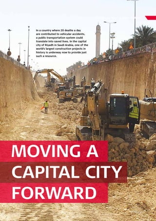
  • 1. In a country where 20 deaths a day are contributed to vehicular accidents, a public transportation system could translate into saved lives. In the capital city of Riyadh in Saudi Arabia, one of the world’s largest construction projects in history is underway now to provide just such a resource. Written by Monica Miller Rodgers MOVING A CAPITAL CITY FORWARD 31 | Reporter 74 ©Strukton
  • 2. 32 | Reporter 74 With 90 per cent of the nearly 6 million population in the city using cars, a sustainable public transportation system was desperately needed. The current public transportation system, though, was close to non- existent with no metro and no bus lines travelling inside the city. In 2014, ground was broken to begin the Riyadh Metro Project with an ambitious due date of late 2018. The city’s first rail metro will have six lines with 85 stations covering 176 kilometres with about 40 per cent of the lines underground. The metro will be able to move up to 3 million passengers a day. All together, the project comes in at an approximate 20.1 billion Euros. FINDING COMMON GLOBAL SOLUTIONS To build one of the largest infrastructure construction projects in the world, it took a multicultural team. Three multinational consortiums are working together on the project, combining companies from around the world. FAST Consortium, led by FCC Construccion from Spain with Freyssinet of Saudi Arabia, Atkins of England, Alstom and Setec from France, Samsung C&T from South Korea, Typsa also of Spain, and Strukton of The Netherlands, was contracted to construct and design Lines 4 (Yellow), 5 (Green) and 6 (Purple) of the metro. The project oversees 64.6km of the rail track, 29.8km of viaducts and 24 stations at an overall cost of 7.1 billion Euros. Construction of these three lines is overseen by three partners in the Consortium: FCC Construccion, Samsung C&T and Strukton. Each line has a dedicated survey team with all using solutions from Leica Geosystems. Strukton, in charge of Line 6 (Purple), has been tasked with capturing data for topographic surveys, as-built checks, volume calculation, and inventory of existing utilities. The technology company specialising in rail systems and civil infrastructure is also in charge of stakeouts for construction and deviation monitoring. “Though these are typical tasks for us, the sheer size of the project is new for us,” said Clemens Tierie, survey manager for Strukton. “Only on Line 6, I have 28 teams with more than 10 nationalities represented.” With such a diverse mix, Tierie needed to find common solutions familiar to all the team members. He found that in Leica Geosystems. Using a combination of total stations, GNSS receivers, and construction lasers and levels combined with measurement software, the Strukton team is well on its way to completing the project on time and on budget. “Surveying is teamwork, and surveyors from all across the world know and appreciate Leica Geosystems solutions,” said Tierie. RACING AGAINST THE ELEMENTS With an ambitious deadline of just more than four years for such a large project, Tierie knew the team couldn’t allow for any disruption. First, working in temperatures upward of 50 degrees Celsius in desert conditions, they needed to be able to trust the instruments to withstand. “Due to our time schedule, there have been many days we’ve had to work straight through. We couldn’t wait for evenings or cooler temperatures,” said Tierie. “With the durability of our Leica Viva TS15 total station, we were able to perform high-accuracy stakeouts at any part of the working day. This enabled us to ensure everything was ready for construction to start on time.” Using Leica Geo Office and Infinity software, the team was able to instantly transfer reality capture data back to the office from the field for quicker processing. This way, if there were extra measurements needed, the team could do so while on site without having to return later. The team also used the Leica Rugby rotating laser and construction levels to perform accurate as-built checks. With almost all of Leica Geosystems instruments able to operate from -20 to 50 degrees Celsius, the Strukton team is on schedule to finish the project. ©Strukton
  • 3. 33 | Reporter 74 Next, as the largest city in the country and with a unprecedented growth in the past decade, the city’s utilities have created a complex infrastructure challenge. While constructing the Riyadh Metro Line, the team had to remain vigilant not to interfere with any of the buried utilities or lines running above, many times not knowing exactly where these utilities were located. Combining the Leica GS14 GNSS smart antenna with the Leica GR10 GNSS reference station receiver, Tierie and his team were able to precisely locate and account for rogue utilities. Saving precious time and avoiding dangerous utility strikes, the team was able to work quicker, safer and more efficiently. “Due to precise locating abilities of these instruments, we were able to inform our designers in the early stages of the project exactly where the utilities were located so they could incorporate this new information in the metro design,” said Tierie. Finally, the constant ongoing construction put roads and buildings in unstable environments. With the vibration from heavy machinery, such as when excavating trenches for cut and cover tunnels, these city assets were in danger of uneven and unsafe settlement. In conjunction with their measuring task, the surveyors were also in charge of monitoring the ongoing construction and its impact on the surrounding areas. “With the accuracy of the Leica TM50 total station, we were able to quickly determine if construction operations were negatively impacting surrounding structures,” said Tierie. “Improving the safety for the crew and community, our work has been well received here in Riyadh.” The team has future plans to supplement the monitoring process with Leica GeoMoS monitoring software for instant alerts to deviations in the structures. WORLDWIDE SUPPORT Perhaps even more critical in an international environment such as the construction site of the Riyadh Metro Project is the assurance of support at anytime, anywhere. Tierie says he arranged the project in Saudi Arabia through a combined effort of Leica Geosystems locations. His former Leica Geosystems network in The Netherlands with support from the Dubai and Switzerland locations and the local dealer in Riyadh all pitched in to make the project possible. Since moving to the desert nation at the beginning of the project in 2014, he has relied on the excellent support he receives from the many locations of Leica Geosystems. “The quality of Leica Geosystems solutions is great, but the support for me is the biggest benefit. I’ve received very good support from Leica Geosystems Netherlands, Dubai and the local dealer SITML,” said Tierie. “Due to the Active Customer Care support, we can quickly and efficiently handle any problems we encounter on site.” ©Strukton©Strukton