SlideShare a Scribd company logo
1 of 1
Download to read offline
CONTINENTAL MAPPING
www.continentalmapping.com
888.815.3327
PROJECT PROFILE: Minnesota Department of Transportation
Mobile Lidar
Congress’ passage of MAP-21 on July 6, 2012 created a mandate for
having an asset management plan to track the condition and performance
of roadways and bridges. An accurate geospatial inventory of all the trans-
portation assets within a corridor is critical for effective long term viability
and supports the need for more cost effective approaches to managing
transportation assets. However, an inventory is more than just a simple
diagram showing what exists. The inventory must include detailed descrip-
tions of all components that comprise an asset, installation dates, manufac-
turer, and warranty information, as well as details pertaining to its condition.
Asset management is typically done at lesser accuracies but mobile lidar
offers the opportunity collect this information at up-to survey-grade accura-
cy.
The Minnesota Department of Transportation’s (MnDOT) 694 project is a
great example of a project addressing these needs. The interstate is an
auxiliary beltway that allows I-94 traffic to flow north around the Twin Cities,
and a main route for commuters in the northern suburbs and sees a large
amount of freight traffic, making it a priority corridor. The infrastructure is
complicated by densely packed communities and intricate.
Key requirements for the project included safety of all field work, speed of
data collection, processing, and delivery, creating all the mapping products to support design, and generating a geospa-
tial asset inventory to support implementation of an enterprise asset management system. Mobile lidar addressed the
field safety issue by expediting data collection on the roadways. Mapping products extracted from the mobile lidar
included planimetric mapping (e.g., paint lines, edge of pavement, jersey barriers, bridge clearances, and signage), a
TIN of the surface for understanding water flow, and ground-based imagery. Continental Mapping utilized an integrated
forward facing high definition camera to acquire all sign features and populate an ArcGIS GeoDatabase for eventual
use with MnDOT’s enterprise asset management (EAM) system. MnDOT plans to use this data and EAM for more
effective inventorying, budgeting, and replacement scheduling.
All roadway mapping completed within this project is being integrated with another I-694 project focused on infrastruc-
ture evaluation and planning. MnDOT has engaged Continental Mapping to complete 1”=100’ mapping and digital
orthophotos from aerial imagery for areas beyond the hard surfaces for the same corridor. The integration of these
projects offers MnDOT a final dataset that will support numerous needs and meet their core goals of financial effective-
ness.

More Related Content

Viewers also liked

Survey Grade LiDAR Technologies for Transportation Engineering
Survey Grade LiDAR Technologies for Transportation EngineeringSurvey Grade LiDAR Technologies for Transportation Engineering
Survey Grade LiDAR Technologies for Transportation EngineeringQuantum Spatial
 
"Why LiDAR?" Presentation
"Why LiDAR?" Presentation"Why LiDAR?" Presentation
"Why LiDAR?" PresentationLidar Blog
 
LIDAR TECHNOLOGY AND ITS APPLICATION ON FORESTRY
LIDAR TECHNOLOGY AND ITS APPLICATION ON FORESTRYLIDAR TECHNOLOGY AND ITS APPLICATION ON FORESTRY
LIDAR TECHNOLOGY AND ITS APPLICATION ON FORESTRYAbhiram Kanigolla
 
light-detection-and-ranging(lidar)
 light-detection-and-ranging(lidar) light-detection-and-ranging(lidar)
light-detection-and-ranging(lidar)sandeep reddy
 
The Top Skills That Can Get You Hired in 2017
The Top Skills That Can Get You Hired in 2017The Top Skills That Can Get You Hired in 2017
The Top Skills That Can Get You Hired in 2017LinkedIn
 

Viewers also liked (9)

Lidar
LidarLidar
Lidar
 
Survey Grade LiDAR Technologies for Transportation Engineering
Survey Grade LiDAR Technologies for Transportation EngineeringSurvey Grade LiDAR Technologies for Transportation Engineering
Survey Grade LiDAR Technologies for Transportation Engineering
 
"Why LiDAR?" Presentation
"Why LiDAR?" Presentation"Why LiDAR?" Presentation
"Why LiDAR?" Presentation
 
LIDAR TECHNOLOGY AND ITS APPLICATION ON FORESTRY
LIDAR TECHNOLOGY AND ITS APPLICATION ON FORESTRYLIDAR TECHNOLOGY AND ITS APPLICATION ON FORESTRY
LIDAR TECHNOLOGY AND ITS APPLICATION ON FORESTRY
 
LIDAR
LIDARLIDAR
LIDAR
 
Pile foundation ppt
Pile foundation pptPile foundation ppt
Pile foundation ppt
 
light-detection-and-ranging(lidar)
 light-detection-and-ranging(lidar) light-detection-and-ranging(lidar)
light-detection-and-ranging(lidar)
 
LIDAR
LIDARLIDAR
LIDAR
 
The Top Skills That Can Get You Hired in 2017
The Top Skills That Can Get You Hired in 2017The Top Skills That Can Get You Hired in 2017
The Top Skills That Can Get You Hired in 2017
 

More from Continental Mapping Consultants

Continental Mapping Projects - Tualatin National Wildlife Refuge
Continental Mapping Projects - Tualatin National Wildlife RefugeContinental Mapping Projects - Tualatin National Wildlife Refuge
Continental Mapping Projects - Tualatin National Wildlife RefugeContinental Mapping Consultants
 
Continental mapping projects las vegas water treatment plant
Continental mapping projects   las vegas water treatment plantContinental mapping projects   las vegas water treatment plant
Continental mapping projects las vegas water treatment plantContinental Mapping Consultants
 

More from Continental Mapping Consultants (20)

Continental Mapping Introduces TheGeoFoundry.com
Continental Mapping Introduces TheGeoFoundry.comContinental Mapping Introduces TheGeoFoundry.com
Continental Mapping Introduces TheGeoFoundry.com
 
Continental Mapping Projects - Wood Road Re-alignment
Continental Mapping Projects - Wood Road Re-alignmentContinental Mapping Projects - Wood Road Re-alignment
Continental Mapping Projects - Wood Road Re-alignment
 
Transportation Mapping
Transportation MappingTransportation Mapping
Transportation Mapping
 
Storygraphic - The Continental Mapping Story
Storygraphic - The Continental Mapping StoryStorygraphic - The Continental Mapping Story
Storygraphic - The Continental Mapping Story
 
Continental Mapping Projects - ATC Dane County
Continental Mapping Projects - ATC Dane CountyContinental Mapping Projects - ATC Dane County
Continental Mapping Projects - ATC Dane County
 
Continental Mapping Projects - USACE Cleveland Levee
Continental Mapping Projects - USACE Cleveland LeveeContinental Mapping Projects - USACE Cleveland Levee
Continental Mapping Projects - USACE Cleveland Levee
 
Continental Mapping Projects - USACE Pine Creek
Continental Mapping Projects - USACE Pine CreekContinental Mapping Projects - USACE Pine Creek
Continental Mapping Projects - USACE Pine Creek
 
Map America - 10 Tallest Dams Infographic
Map America - 10 Tallest Dams InfographicMap America - 10 Tallest Dams Infographic
Map America - 10 Tallest Dams Infographic
 
Continental Mapping Projects - Chattanooga
Continental Mapping Projects - ChattanoogaContinental Mapping Projects - Chattanooga
Continental Mapping Projects - Chattanooga
 
Continental Mapping Projects - Tualatin National Wildlife Refuge
Continental Mapping Projects - Tualatin National Wildlife RefugeContinental Mapping Projects - Tualatin National Wildlife Refuge
Continental Mapping Projects - Tualatin National Wildlife Refuge
 
Continental Mapping - On All Continents
Continental Mapping - On All Continents Continental Mapping - On All Continents
Continental Mapping - On All Continents
 
FAA UAS Map
FAA UAS MapFAA UAS Map
FAA UAS Map
 
Red Wing Bridge Project
Red Wing Bridge ProjectRed Wing Bridge Project
Red Wing Bridge Project
 
Aztalan Project
Aztalan ProjectAztalan Project
Aztalan Project
 
Continental Mapping Projects - FEMA Butler Co. MO
Continental Mapping Projects - FEMA Butler Co. MOContinental Mapping Projects - FEMA Butler Co. MO
Continental Mapping Projects - FEMA Butler Co. MO
 
Continental Mapping Projects - TDOT Grainger Co.
Continental Mapping Projects - TDOT Grainger Co.Continental Mapping Projects - TDOT Grainger Co.
Continental Mapping Projects - TDOT Grainger Co.
 
Continental mapping projects las vegas water treatment plant
Continental mapping projects   las vegas water treatment plantContinental mapping projects   las vegas water treatment plant
Continental mapping projects las vegas water treatment plant
 
Continental mapping projects indot south split
Continental mapping projects   indot south splitContinental mapping projects   indot south split
Continental mapping projects indot south split
 
Continental Mapping Projects - HWY F
Continental Mapping Projects - HWY FContinental Mapping Projects - HWY F
Continental Mapping Projects - HWY F
 
Continental Mapping Projects - Dodger Stadium
Continental Mapping Projects - Dodger StadiumContinental Mapping Projects - Dodger Stadium
Continental Mapping Projects - Dodger Stadium
 

Recently uploaded

lifi-technology with integration of IOT.pptx
lifi-technology with integration of IOT.pptxlifi-technology with integration of IOT.pptx
lifi-technology with integration of IOT.pptxsomshekarkn64
 
Correctly Loading Incremental Data at Scale
Correctly Loading Incremental Data at ScaleCorrectly Loading Incremental Data at Scale
Correctly Loading Incremental Data at ScaleAlluxio, Inc.
 
Call Us ≽ 8377877756 ≼ Call Girls In Shastri Nagar (Delhi)
Call Us ≽ 8377877756 ≼ Call Girls In Shastri Nagar (Delhi)Call Us ≽ 8377877756 ≼ Call Girls In Shastri Nagar (Delhi)
Call Us ≽ 8377877756 ≼ Call Girls In Shastri Nagar (Delhi)dollysharma2066
 
Concrete Mix Design - IS 10262-2019 - .pptx
Concrete Mix Design - IS 10262-2019 - .pptxConcrete Mix Design - IS 10262-2019 - .pptx
Concrete Mix Design - IS 10262-2019 - .pptxKartikeyaDwivedi3
 
Introduction to Machine Learning Unit-3 for II MECH
Introduction to Machine Learning Unit-3 for II MECHIntroduction to Machine Learning Unit-3 for II MECH
Introduction to Machine Learning Unit-3 for II MECHC Sai Kiran
 
Introduction-To-Agricultural-Surveillance-Rover.pptx
Introduction-To-Agricultural-Surveillance-Rover.pptxIntroduction-To-Agricultural-Surveillance-Rover.pptx
Introduction-To-Agricultural-Surveillance-Rover.pptxk795866
 
Class 1 | NFPA 72 | Overview Fire Alarm System
Class 1 | NFPA 72 | Overview Fire Alarm SystemClass 1 | NFPA 72 | Overview Fire Alarm System
Class 1 | NFPA 72 | Overview Fire Alarm Systemirfanmechengr
 
Work Experience-Dalton Park.pptxfvvvvvvv
Work Experience-Dalton Park.pptxfvvvvvvvWork Experience-Dalton Park.pptxfvvvvvvv
Work Experience-Dalton Park.pptxfvvvvvvvLewisJB
 
US Department of Education FAFSA Week of Action
US Department of Education FAFSA Week of ActionUS Department of Education FAFSA Week of Action
US Department of Education FAFSA Week of ActionMebane Rash
 
CCS355 Neural Network & Deep Learning Unit II Notes with Question bank .pdf
CCS355 Neural Network & Deep Learning Unit II Notes with Question bank .pdfCCS355 Neural Network & Deep Learning Unit II Notes with Question bank .pdf
CCS355 Neural Network & Deep Learning Unit II Notes with Question bank .pdfAsst.prof M.Gokilavani
 
Software and Systems Engineering Standards: Verification and Validation of Sy...
Software and Systems Engineering Standards: Verification and Validation of Sy...Software and Systems Engineering Standards: Verification and Validation of Sy...
Software and Systems Engineering Standards: Verification and Validation of Sy...VICTOR MAESTRE RAMIREZ
 
Oxy acetylene welding presentation note.
Oxy acetylene welding presentation note.Oxy acetylene welding presentation note.
Oxy acetylene welding presentation note.eptoze12
 
Application of Residue Theorem to evaluate real integrations.pptx
Application of Residue Theorem to evaluate real integrations.pptxApplication of Residue Theorem to evaluate real integrations.pptx
Application of Residue Theorem to evaluate real integrations.pptx959SahilShah
 
IVE Industry Focused Event - Defence Sector 2024
IVE Industry Focused Event - Defence Sector 2024IVE Industry Focused Event - Defence Sector 2024
IVE Industry Focused Event - Defence Sector 2024Mark Billinghurst
 

Recently uploaded (20)

9953056974 Call Girls In South Ex, Escorts (Delhi) NCR.pdf
9953056974 Call Girls In South Ex, Escorts (Delhi) NCR.pdf9953056974 Call Girls In South Ex, Escorts (Delhi) NCR.pdf
9953056974 Call Girls In South Ex, Escorts (Delhi) NCR.pdf
 
lifi-technology with integration of IOT.pptx
lifi-technology with integration of IOT.pptxlifi-technology with integration of IOT.pptx
lifi-technology with integration of IOT.pptx
 
Correctly Loading Incremental Data at Scale
Correctly Loading Incremental Data at ScaleCorrectly Loading Incremental Data at Scale
Correctly Loading Incremental Data at Scale
 
Design and analysis of solar grass cutter.pdf
Design and analysis of solar grass cutter.pdfDesign and analysis of solar grass cutter.pdf
Design and analysis of solar grass cutter.pdf
 
Call Us ≽ 8377877756 ≼ Call Girls In Shastri Nagar (Delhi)
Call Us ≽ 8377877756 ≼ Call Girls In Shastri Nagar (Delhi)Call Us ≽ 8377877756 ≼ Call Girls In Shastri Nagar (Delhi)
Call Us ≽ 8377877756 ≼ Call Girls In Shastri Nagar (Delhi)
 
young call girls in Green Park🔝 9953056974 🔝 escort Service
young call girls in Green Park🔝 9953056974 🔝 escort Serviceyoung call girls in Green Park🔝 9953056974 🔝 escort Service
young call girls in Green Park🔝 9953056974 🔝 escort Service
 
Concrete Mix Design - IS 10262-2019 - .pptx
Concrete Mix Design - IS 10262-2019 - .pptxConcrete Mix Design - IS 10262-2019 - .pptx
Concrete Mix Design - IS 10262-2019 - .pptx
 
Introduction to Machine Learning Unit-3 for II MECH
Introduction to Machine Learning Unit-3 for II MECHIntroduction to Machine Learning Unit-3 for II MECH
Introduction to Machine Learning Unit-3 for II MECH
 
Introduction-To-Agricultural-Surveillance-Rover.pptx
Introduction-To-Agricultural-Surveillance-Rover.pptxIntroduction-To-Agricultural-Surveillance-Rover.pptx
Introduction-To-Agricultural-Surveillance-Rover.pptx
 
Class 1 | NFPA 72 | Overview Fire Alarm System
Class 1 | NFPA 72 | Overview Fire Alarm SystemClass 1 | NFPA 72 | Overview Fire Alarm System
Class 1 | NFPA 72 | Overview Fire Alarm System
 
Work Experience-Dalton Park.pptxfvvvvvvv
Work Experience-Dalton Park.pptxfvvvvvvvWork Experience-Dalton Park.pptxfvvvvvvv
Work Experience-Dalton Park.pptxfvvvvvvv
 
US Department of Education FAFSA Week of Action
US Department of Education FAFSA Week of ActionUS Department of Education FAFSA Week of Action
US Department of Education FAFSA Week of Action
 
CCS355 Neural Network & Deep Learning Unit II Notes with Question bank .pdf
CCS355 Neural Network & Deep Learning Unit II Notes with Question bank .pdfCCS355 Neural Network & Deep Learning Unit II Notes with Question bank .pdf
CCS355 Neural Network & Deep Learning Unit II Notes with Question bank .pdf
 
Software and Systems Engineering Standards: Verification and Validation of Sy...
Software and Systems Engineering Standards: Verification and Validation of Sy...Software and Systems Engineering Standards: Verification and Validation of Sy...
Software and Systems Engineering Standards: Verification and Validation of Sy...
 
🔝9953056974🔝!!-YOUNG call girls in Rajendra Nagar Escort rvice Shot 2000 nigh...
🔝9953056974🔝!!-YOUNG call girls in Rajendra Nagar Escort rvice Shot 2000 nigh...🔝9953056974🔝!!-YOUNG call girls in Rajendra Nagar Escort rvice Shot 2000 nigh...
🔝9953056974🔝!!-YOUNG call girls in Rajendra Nagar Escort rvice Shot 2000 nigh...
 
Oxy acetylene welding presentation note.
Oxy acetylene welding presentation note.Oxy acetylene welding presentation note.
Oxy acetylene welding presentation note.
 
young call girls in Rajiv Chowk🔝 9953056974 🔝 Delhi escort Service
young call girls in Rajiv Chowk🔝 9953056974 🔝 Delhi escort Serviceyoung call girls in Rajiv Chowk🔝 9953056974 🔝 Delhi escort Service
young call girls in Rajiv Chowk🔝 9953056974 🔝 Delhi escort Service
 
Exploring_Network_Security_with_JA3_by_Rakesh Seal.pptx
Exploring_Network_Security_with_JA3_by_Rakesh Seal.pptxExploring_Network_Security_with_JA3_by_Rakesh Seal.pptx
Exploring_Network_Security_with_JA3_by_Rakesh Seal.pptx
 
Application of Residue Theorem to evaluate real integrations.pptx
Application of Residue Theorem to evaluate real integrations.pptxApplication of Residue Theorem to evaluate real integrations.pptx
Application of Residue Theorem to evaluate real integrations.pptx
 
IVE Industry Focused Event - Defence Sector 2024
IVE Industry Focused Event - Defence Sector 2024IVE Industry Focused Event - Defence Sector 2024
IVE Industry Focused Event - Defence Sector 2024
 

Asset Management and High Accuracy Mobile Lidar for Minnesota DOT

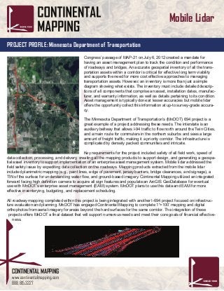
  • 1. CONTINENTAL MAPPING www.continentalmapping.com 888.815.3327 PROJECT PROFILE: Minnesota Department of Transportation Mobile Lidar Congress’ passage of MAP-21 on July 6, 2012 created a mandate for having an asset management plan to track the condition and performance of roadways and bridges. An accurate geospatial inventory of all the trans- portation assets within a corridor is critical for effective long term viability and supports the need for more cost effective approaches to managing transportation assets. However, an inventory is more than just a simple diagram showing what exists. The inventory must include detailed descrip- tions of all components that comprise an asset, installation dates, manufac- turer, and warranty information, as well as details pertaining to its condition. Asset management is typically done at lesser accuracies but mobile lidar offers the opportunity collect this information at up-to survey-grade accura- cy. The Minnesota Department of Transportation’s (MnDOT) 694 project is a great example of a project addressing these needs. The interstate is an auxiliary beltway that allows I-94 traffic to flow north around the Twin Cities, and a main route for commuters in the northern suburbs and sees a large amount of freight traffic, making it a priority corridor. The infrastructure is complicated by densely packed communities and intricate. Key requirements for the project included safety of all field work, speed of data collection, processing, and delivery, creating all the mapping products to support design, and generating a geospa- tial asset inventory to support implementation of an enterprise asset management system. Mobile lidar addressed the field safety issue by expediting data collection on the roadways. Mapping products extracted from the mobile lidar included planimetric mapping (e.g., paint lines, edge of pavement, jersey barriers, bridge clearances, and signage), a TIN of the surface for understanding water flow, and ground-based imagery. Continental Mapping utilized an integrated forward facing high definition camera to acquire all sign features and populate an ArcGIS GeoDatabase for eventual use with MnDOT’s enterprise asset management (EAM) system. MnDOT plans to use this data and EAM for more effective inventorying, budgeting, and replacement scheduling. All roadway mapping completed within this project is being integrated with another I-694 project focused on infrastruc- ture evaluation and planning. MnDOT has engaged Continental Mapping to complete 1”=100’ mapping and digital orthophotos from aerial imagery for areas beyond the hard surfaces for the same corridor. The integration of these projects offers MnDOT a final dataset that will support numerous needs and meet their core goals of financial effective- ness.