1. David R. Markwood, PE & Tyler R. Longberry, PE April 8, 2015
FLOODWAY MAPPING WITH HEC-RAS 5.0
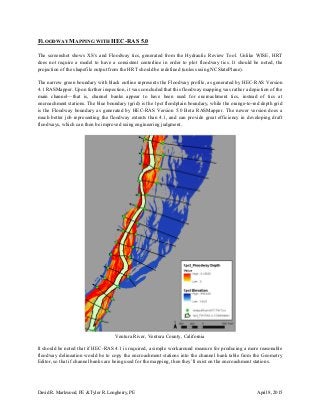
The screenshot shows XS’s and Floodway tics, generated from the Hydraulic Review Tool. Unlike WISE, HRT
does not require a model to have a consistent centerline in order to plot floodway tics. It should be noted, the
projection of the shapefile output from the HRT should be redefined (unless using NCStatePlane).
The narrow green boundary with black outline represents the Floodway profile, as generated by HEC-RAS Version
4.1 RASMapper. Upon further inspection, it was concluded that this floodway mapping was rather a depiction of the
main channel—that is, channel banks appear to have been used for encroachment tics, instead of tics at
encroachment stations. The blue boundary (grid) is the 1pct floodplain boundary, while the orange-to-red depth grid
is the Floodway boundary as generated by HEC-RAS Version 5.0 Beta RASMapper. The newer version does a
much better job representing the floodway extents than 4.1, and can provide great efficiency in developing draft
floodways, which can then be improved using engineering judgment.
Ventura River, Ventura County, California
It should be noted that if HEC-RAS 4.1 is required, a simple workaround measure for producing a more reasonable
floodway delineation would be to copy the encroachment stations into the channel bank table from the Geometry
Editor, so that if channel banks are being used for the mapping, then they’ll exist on the encroachment stations.