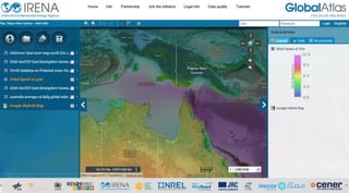
Papua new guinea
•
0 likes•292 views

Next for the day is Papua New Guinea! The map shows wind speeds at 50m height over the Pacific island country. In this map you would also find layers on protected areas, topography, land-cover, and population density per kilometer. The wind map covering Papua New Guinea is shared from the MERRA dataset by Sander+Partners. The layers on protected areas and population density have been shared by UNEP and Oakridge National Laboratory (ORNL) respectively Access the map through: http://irena.masdar.ac.ae/?map=324