1. 1
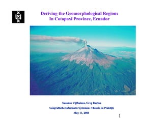
Deriving the Geomorphological Regions
In Cotopaxi Province, Ecuador
Suzanne Vijfhuizen, Greg BurtonSuzanne Vijfhuizen, Greg Burton
Geografische Informatie Systemen: Theorie en PraktijkGeografische Informatie Systemen: Theorie en Praktijk
May 11, 2004May 11, 2004
2. 2
Deriving the Geomorphological Regions
In Cotopaxi Province, Ecuador
Geografische Informatie Systemen
Theorie en Praktijk Mission Statement
Universiteit van Amsterdam
Central Course Theme: As part of the GIS-course, Geografische
Informatie Systemen: Theorie en Praktijk, a case study was conducted
to demonstrate knowledge of GIS processes. The study project was
designed to derive theoretical geomorphology landscape units within
the Cotopaxi Province, Ecuador.
Tools: ESRI® ArcGIS 8.3 ™, Spatial Analyst ™, 3D Analyst ™,
ArcToolbox ™, ArcCatalog ™, ArcEditor ™, ArcScene ™, ERDAS
Imagine™, Microsoft Excel ™, Geomorphologic Theory.
Research Question: Can Geomorphological Regions be predicted and
derived using morphometric criteria, spatial data together with
ArcGIS?
3. 3
Deriving the Geomorphological Regions
In Cotopaxi Province, Ecuador
Ecuador & Cotopaxi Province Study Area
Location: Ecuador is located on the northwest coast of South
America between approximately 1o
north latitude and 5o
South
latitude.
Project Location: Cotopaxi Province straddles the crests of the
Cordillera Occidental and the Cordillera Oriental (Andes).
Climate: Tropical and Tropical Monsoon, with local Humid
Temperate, Humid Dry, and Arid in project area.
Geology: Three main regions: the coastal plain, the two Andean
ranges, and the upper Amazon Basin.
Hydrology: Headwaters of Pacific Ocean and Amazon Basin.
Soils: Andepts or Andisols of recent volcanic origin.
Universiteit van Amsterdam
4. 4
Deriving the Geomorphological Regions
In Cotopaxi Province, Ecuador
Methodology: GIS & Related Processes
Universiteit van Amsterdam
Processes
•Surface Processes Modeling
•Metadata & Database Creation
•Reprojecting
•3 D scene Building & Graphics Creation
•TIN Model Creation and Clipping
•Spatial Analyst: Raster Calculator, Vector Creation
•3D Analyst: Interpolation of Continuous Surfaces
•Shapefile Creation & Editing
•Vector Intersection, Merging, & Clipping
•Thematic Data Creation and Editing
•Coverage Converting
•Raster Mosaicing & Clipping
•Spreadsheet Analysis and Charting
5. 5
Deriving the Geomorphological Regions
In Cotopaxi Province, Ecuador
Methodology: Creating the Geomorphologic Map
Universiteit van Amsterdam
Morphometric Derivation: Using Elevation and Slope
criteria
in modeling geomorphology, 15 elevation Intervals and
4 Slope intervals for 60 Geomorphic classes.
Mapping Geomorphological Regions: TIN Model, Elevation
and Slope data used to create maps displaying elevation, slope,
Cotopaxi Geomorphological Regions, and study area
6. 6
Deriving the Geomorphological Regions
In Cotopaxi Province, Ecuador
Methodology: Project Area Correlation
Universiteit van Amsterdam
Checking Geomorphology: Soil formation factors (parent
material, climate, topography, biota, and time) are integral to
Geomorphological processes (weathering, mass wasting,
alluvial, glacial, aeolian, volcanism and tectonics).
Using this: Geomorphology and Soils can be correlated by GIS
Intersection and used to check derived geomorphological
regions.
Visualizing Topography: Topography projected into 3D space
was compared for correlation.
7. 7
Deriving the Geomorphological Regions
In Cotopaxi Province, Ecuador
Results and Discussion
Universiteit van Amsterdam
Project Constraints: The goal of this study was to derive a
geomorphological map of Cotopaxi Province of Ecuador based
on morphometric constraints, and then correlated with available
and derived data. However due to lack of time, large files and
processing speed a study area was selected for the comparison.
Morphometric Derivation Review: Volcanism, which is not a
climatic based geomorphological process, might not be predicted
based on morphometric criteria that is implicated in climatically
driven processes. Additionally, because of latitude and recent
volcanic activity, glacial landforms are not in evidence.
However, other geomorphology landscape units were found in
predicted areas.
Soils and Precipitation Correlation: Soil types were correlated
to volcanism and a derived precipitation gradient.
8. 8
Deriving the Geomorphological Regions
In Cotopaxi Province, Ecuador
Conclusion
Though the derived unsupervised geomorphic classification
scheme was found to be not always accurate, especially within
the volcanic and glaciation processes units, other derived
processes were found to correspond to the right derived
geomorphology, especially those areas derived as alluvial,
alluvial/aeolian, alluvial mass movement, and mass movement.
Within the current context, we are dealing with a very young
volcanic landscape where concepts of surface processes that are
only restricted to slope and elevation may not be able to account
for processes; and time scales that too short for these competing
simultaneous processes to express themselves completely.
Universiteit van Amsterdam