SlideShare a Scribd company logo
1 of 84
History of Urban Form
Density
A. Measures based upon people or houses. Most common measures:
1. Number of persons per unit of land (expressed as people per acre, hectare, square mile, square kilometer, etc.
2. Dwelling Units per unit of land (expressed as dwelling units per acre, hectare, square mile, square kilometer, etc.
3. Size of lot or parcel (an extension of no. 2, expressed as ¼ acre lot, ½ acre lot etc.
B. Measures based on constitutional frame (infrastructure)
1. Intersections per unit of land (expressed as intersections per acre, hectare, square mile, square kilometer, etc.
2. Total length of road or street per unit of land
3. Block density
COA 6151: History of Urban Form
Constitution and Representation
COA 6151: History of Urban Form
Constitution and Representation
Housing Unit Density by Distance from the city's CBD
0
3
6
9
12
15
18
21
24
27
1
3
5
7
9
11
13
15
17
19
21
23
25
27
29
31
33
35
37
39
41
43
45
47
49
51
Distance (Miles)
HU/Acre
Atlanta Chicago New York
Density Gradients for Three Metro Areas
COA 6151: History of Urban Form
Constitution and Representation
Observation: Since 1928, Block sizes have increased by a factor of 3.2 from the average block size prior to 1928.
Pre 1928 Block Size Post 1928 Block Size
avg. max avg max
acres acres acres acres
1 Atlanta, GA 3.70 8.26 1 Atlanta, GA 22.87 44.49
2 Boston, MA 3.09 4.13 2 Boston, MA 9.45 14.46
3 Baltimore, Md 3.29 5.78 3 Baltimore, Md 14.93 22.72
4 Charleston, S.C. 4.12 6.07 4 Charleston, S.C. 16.89 25.25
5 Chicago, Illinois 3.51 4.96 5 Chicago, Illinois 14.74 19.10
6 Los Angeles, CA 4.41 7.89 6 Los Angeles, CA 8.01 16.08
7 New York, N.Y. (Manhattan) 2.60 3.67 7 New York, N.Y. (Manhattan) 7.72 13.31
8 Omaha, Nebraska 4.34 8.26 8 Omaha, Nebraska 8.27 13.42
9 Portland, Oregon 1.92 3.72 9 Portland, Oregon 2.69 4.24
10 Philadelphia, Pennsylvania 3.07 6.33 10 Philadelphia, Pennsylvania 5.03 5.88
Average 3.41 5.91 11.06 17.90
Median 3.40 5.93 8.86 15.27
Std. Dev 0.79 1.80 6.14 11.42
COA 6151: History of Urban Form
Constitution and Representation
Observation 2: the standard deviation of average block size in the following selected cities has increased from .79 to 6.14
from pre-1928 subdivision to post -1928 subdivision.
Pre 1928 Block Size Post 1928 Block Size
avg. max avg max
acres acres acres acres
1 Atlanta, GA 3.70 8.26 1 Atlanta, GA 22.87 44.49
2 Boston, MA 3.09 4.13 2 Boston, MA 9.45 14.46
3 Baltimore, Md 3.29 5.78 3 Baltimore, Md 14.93 22.72
4 Charleston, S.C. 4.12 6.07 4 Charleston, S.C. 16.89 25.25
5 Chicago, Illinois 3.51 4.96 5 Chicago, Illinois 14.74 19.10
6 Los Angeles, CA 4.41 7.89 6 Los Angeles, CA 8.01 16.08
7 New York, N.Y. (Manhattan) 2.60 3.67 7 New York, N.Y. (Manhattan) 7.72 13.31
8 Omaha, Nebraska 4.34 8.26 8 Omaha, Nebraska 8.27 13.42
9 Portland, Oregon 1.92 3.72 9 Portland, Oregon 2.69 4.24
10 Philadelphia, Pennsylvania 3.07 6.33 10 Philadelphia, Pennsylvania 5.03 5.88
Average 3.41 5.91 11.06 17.90
Median 3.40 5.93 8.86 15.27
Std. Dev 0.79 1.80 6.14 11.42
COA 6151: History of Urban Form
Constitution and Representation
COA 6151: History of Urban Form
Constitution and Representation
Street and block density
Clockwise from upper left
• Paris
• Brasilia
• Istanbul
• Atlanta
History of Urban Form
Form
Structure of Streets and Blocks
.
COA 6151: History of Urban Form
Constitution and Representation
Morphological (Form)
COMPARISON
B L O C K D E N D R I T I C
COA 6151: History of Urban Form
Constitution and Representation
Morphological (Form)
COMPARISON
PUBLIC SPACE
B L O C K D E N D R I T I C
COA 6151: History of Urban Form
Constitution and Representation
Morphological (Form)
COMPARISON
GROWTH
COA 6151: History of Urban Form
Constitution and Representation
Morphological (Form)
COMPARISON
Baghdad: Historic Center c. 1400 AD
Dendritic System of streets within larger “super blocks"
Baghdad: early 20th century suburb
Striated Blocks with superimposed radial avenues
COA 6151: History of Urban Form
Constitution and Representation
Morphological (Form)
COMPARISON
Atlanta: Historic Center c. 1840
Block with rotated grid
Atlanta: Midtown / early 20th c. suburb c. 1900
Deformed Block with rotated grid
COA 6151: History of Urban Form
Constitution and Representation
Morphological (Form)
COMPARISON
Atlanta: Late 20th c. suburb
Dendritic Pattern with “super block”
Baghdad: Historic Center c. 1400 AD
Dendritic System of streets within larger “super blocks"
COA 6151: History of Urban Form
Constitution and Representation
Assur c. 1200 BCE Damascus: Old City as shown c. 800 AD
Philadelphia: 1685 AD
3130'190'
170'
1240'
1370'
1680'
460'
700'
2780'
1530'
5520'
6770'
7540'
690'
2150' 1970' 2640'
1730'
790'
1280'
Windward (Atlanta) 1985 AD
COA 6151: History of Urban Form
Constitution and Representation
COA 6151
ARCH 4151
The History of Urban Form
Lecture 02: Origins of the City: Orient and Occident
COA 6151: History of Urban Form
Origins of the City
Origins of the City
Eastern Mediterranean
to the
Iranian Plateau
COA 6151: History of Urban Form
Origins of the City
HORSES
CATTLE
GOATS
SHEEP
HORSES: Steppes,
Ukraine and Southern
Russia
CATTLE: Northern
India, Indus Valley
GOATS: Northern Iran,
Iraq, Kurdistan
SHEEP: Northern Iran,
Kurdistan, and
Mesopotamia
SHEEP
GOATS
GOATS
Origins of the City
Eastern Mediterranean
to the
Iranian Plateau
7,000 BCE
Catal Huyuk
9,000 BCE
Jericho
4,000 BCE
4,000 BCE
Ur
Uruk
3,000 BCE
COA 6151: History of Urban Form
Origins of the City
9,000 BCE
Gobekli Tepe
Permanent
human
settlements,
Neolithic
period
Cities and
proto-cites.
COA 6151
ARCH 4151
The History of Urban Form
Jericho: 8000 – 3000 BCE
COA 6151: History of Urban Form
Origins of the City
Arch 4151: History of Urban Form
Georgia Institute of Technology
College of Architecture
Origins of the City
Jericho
Jericho: Tell or mound at the site of the original city dating to 8000 BCE. Settlement at Jericho (Jerich or Tel-es-Sultan) was dated by Kathleen Kenyon to extend to 8000-9000 BCE. Occupation is
Generally assigned to three periods prior to the Bronze Age or c. 3000 BCE.
1. Natufian: Proto-Neolithic -- construction at the site apparently began before the invention of agriculture, with construction of stone Natufian culture structures beginning earlier than 9000 BC.
2. PPN A: Pre-Pottery Neolithic A, 8350 BC to 7370 BC. Sometimes called Sultanien. A four hectare settlement surrounded by a stone wall, with a stone tower in the centre of one wall. Round mud-
brick houses. Use of domesticated emmer wheat, barley and pulses and hunting of wild animals.
3. PPN B: Pre-Pottery Neolithic B, 7220 BC to 5850 BC (but carbon-14-dates are few and early). Expanded range of domesticated plants. Possible domestication of sheep. Apparent cult involving
the preservation of human skulls, with facial features reconstructed from plaster and eyes set with shells in some cases.
After the PPN A settlement-phase there was a settlement hiatus of several centuries, then the PPN B settlement was founded on the eroded surface of the tell. The architecture consisted of
rectilinear buildings made of mudbricks on stone foundations. The mudbricks were loaf-shaped with deep thumb prints to facilitate bounding. No building has been excavated in its entirety. Normally,
several rooms cluster around a central courtyard. There is one big room (6.5 x 4 m and 7 x 3 m) with internal divisions, the rest are small, presumably used for storage. The rooms have red or pinkish
terrazzo-floors made of lime. Some impressions of mats made of reeds or rushes have been preserved. The courtyards have clay floors.
Arch 4151: History of Urban Form
Georgia Institute of Technology
College of Architecture
Origins of the City
Jericho
Modern Jericho looking east toward the Jordan Valley from above the Tell
Walls datable to the early Bronze Age or Chalcolithic Period, 3300 BCE
Excavated by Kathleen Kenyon in the late 1940’s, the material record
indicates a substantial break in occupation beginning around 1150 BCE.
Modern Jericho dates to the 12th century AD. Although the walls shown
here date to a period much later than the Neolithic period, Jericho , along
with Catal Huyuk in Turkey can claim the current position as the oldest
“cities” in the world.
Photo courtesy of the Bryn Mawr Collection
Arch 4151: History of Urban Form
Georgia Institute of Technology
College of Architecture
Origins of the City
Jericho
Chalcolithic Period walls at Jericho c. 3300 BCE Defensive work or tower, Jericho 3300 BCE
COA 6151
ARCH 4151
The History of Urban Form
Catal Huyuk: 7000 BCE
COA 6151: History of Urban Form
Origins of the City
Arch 4151: History of Urban Form
Georgia Institute of Technology
College of Architecture
Origins of the City
Catal Huyuk 7000 BCE
Arch 4151: History of Urban Form
Georgia Institute of Technology
College of Architecture
Origins of the City
Catal Huyuk c. 7000 BCE
Arch 4151: History of Urban Form
Georgia Institute of Technology
College of Architecture
Origins of the City
Catal Huyuk c. 7000 BCE
Arch 4151: History of Urban Form
Georgia Institute of Technology
College of Architecture
Origins of the City
Catal Huyuk c. 7000 BCE
Arch 4151: History of Urban Form
Georgia Institute of Technology
College of Architecture
Origins of the City
Catal Huyuk c. 7000 BCE
Arch 4151: History of Urban Form
Georgia Institute of Technology
College of Architecture
Origins of the City
Catal Huyuk c. 7000 BCE
COA 6151
ARCH 4151
The History of Urban Form
Trade and the Development of Writing
5000 – 3000 BCE
COA 6151: History of Urban Form
Origins of the City
1000 BCE
Bronze Age Copper Age in Niger Bantu expansion Late Bronze Age
Early Iron Age
Development of
Indian Iron Age
Chinese Bronze Age
2000 BCE
Bell beaker Chalcolithic
corded ceramic
domestication of the
horse
Neolithic of Ticht /
Tenerean
Middle Bronze
Age (Sumer)
Indus Valley civilization
writing
Chinese Neolithic
of Longshan
3000 BCE
enclosed villages
first megaliths
Chalcolithic
of Central Europe
Hunter-gatherer art
of South Africa
Early Bronze Age Regionalization Era
4000 BCE
Lower Neolithic
Danubian Neolithic
Writing
Mediterranean
and Egyptian Neolithic
Neolithic in East Africa
Writing
Uruk period
Chalcolithic
(copper metallurgy)
Writing
Mehrgarh
Indus Valley
Writing
Neolithic
of Yang-Shao
rice-growing (?)
5000 BCE
Cardial and Linear
Pottery
(agriculture, stock-
rearing, Pottery)
Tardenoisian cultures
Starčevo and Vinča
culture
agriculture, stock-rearing
(pigs, bovine, sheep)
Neolithic of the
Sahara/Sahel
Ubaid period
ceramic ware
Cyprus
Mehrgarh
Hongshan culture of
Northeast Asia (ca. 4700
BC/6700 BP)
7000 BCE Sauveterrian cultures
(gathering of legumes)
Neolithic (Greece and
the Eastern
Mediterranean )
Sesklo and Choirokoitia
Neolithic with ceramic
Ubaid period
Mehrgarh
Neolithic of northern
China
8000 BCE
Backed point
culture
Wiltonian
Pre-ceramic B
Pre-ceramic A
Neolithic in Turkey
(wheat, barley)
hunter gatherers
of Jōmon
(ancient Japan)
TIME Europe
North Africa,
West Africa and
Sahara
Central Africa,
South and East
Africa
Middle East
South Asia, and
Central Asia
East Asia and
South-East Asia
Comparative Time Line
Writing
COA 6151: History of Urban Form
Origins of the City
Trade :
Trade means contact with
other people. Along with
trade of goods is the need
to record inventories, record
exchange value, etc.
COA 6151: History of Urban Form
Origins of the City
COA 6151
ARCH 4151
The History of Urban Form
Writing and Language Groups
5000 – 3000 BCE
COA 6151: History of Urban Form
Origins of the City
Eastern Mediterranean
to the
Iranian Plateau
6000-4000 BCE
Indo-European
Speaking People
Semitic Speaking
People
Around 4,500 years ago. A
large migration of language
groups occurs. While no
evidence of war or other forcible
take-over has been found, a
sudden revolution in agriculture
and language occurs in
Europe..Cattle, Sheep, Goats,
Pigs, etc. appear. Wheat
appears in north Africa and
southern Europe. This would
indicate the transport of
agricultural practices migrating
out of two “hearths”, one in
Africa, the other in Western
Asia.
COA 6151: History of Urban Form
Origins of the City
Origins of the City
Areas of Linguistic influence
Eastern Mediterranean
to the
Iranian Plateau
S E M I T I C
The Semitic family is a member
of the larger Afroasiatic family,
all of whose other five or more
branches are based in Africa.
Largely for this reason, the
ancestors of Proto-Semitic
speakers are believed by many
to have first arrived in the
Middle East from Africa,
possibly as part of the
operation of the “Saharan
pump”, around the late
Neolithic Period. 9500 BC
Note: The Saharan Pump
refers to the cyclical drying of
the Sahara, the last being
associated with the recession
of the Glacial Ice Age. The
theory is that African languages
moved northward and became
isolated in the Nile Valley,
Coastal North Africa, and the
Levant (Eastern Mediterranean)
around 10-12,000 BC.
COA 6151: History of Urban Form
Origins of the City
I N D O - E U R O P E A N
Origins of the City
Areas of Linguistic influence
Eastern Mediterranean
to the
Iranian Plateau
Around 4500 BCE
COA 6151: History of Urban Form
Origins of the City
I N D O - E U R O P E A N
S E M I T I C
Directions of Cultural Exchange
Areas of
Substantial
Cultural
Interchange
Origins of the City
Areas of Linguistic influence
Eastern Mediterranean
to the
Iranian Plateau
COA 6151: History of Urban Form
Origins of the City
Eastern Mediterranean
to the
Iranian Plateau c. 2000 BCE
7,000 BCE
9,000 BCE
4,000 BCE
4,000 BCE
3,000 BCE
COA 6151: History of Urban Form
Origins of the City
Alphabetic writing where a
symbol represents a
“Phoentic” sound
Hieroglyphic writing where
a symbol represents a
word, or multiple words.
Cuneiform writing where multiple
lines and dots represent highly
stylized pictographs,
representing both words and
numbers, grouped as concepts.
These later transformed into
syllable sounds .
Semitic
Modern
Indo-European:
Greek,
Latin Based, (Romance)
Celtic,
Germanic,
Hindi,
Farsi,
Indo-European
Father: Pater, Pita, Pedar
Mother: Mater, Matar
Sky: Akasa
Heart: Kart
Foot: Pad, Ped
King: Rex, Rix, Raj
Modern
Semitic:
Arabic
Hebrew
Geʕez (Ethiopian)
Amharic
Semitic
Father: Ab, Abt , Abba
Mother: Umm, Ima, (ee-ma)
Sky: Samaa ,
Heart: Alb, Elb, Lev
Foot: Regel, Regl
King: Malek, Malik, Melech
Indo-European
COA 6151: History of Urban Form
Origins of the City
Origins of the City
Eastern Mediterranean
to the
Iranian Plateau
I N D O - E U R O P E A N
S E M I T I C
Catal Huyuk: c. 7000 BCE
Jericho c. 8000 BCE
Hattusas 3000 BCE
Uruk 4000 BCE
Ur
Directions of Cultural Exchange
Areas of
Substantial
Cultural
Interchange
COA 6151: History of Urban Form
Origins of the City
COA 6151
ARCH 4151
The History of Urban Form
Uruk and Ur: 4000 – 2000 BCE
COA 6151: History of Urban Form
Origins of the City
Origins of the City
Mesopotamia
Uruk c. 4000 BCE
COA 6151: History of Urban Form
Origins of the City
Origins of the City
Mesopotamia
Uruk
Mounds formed in braided river deltas after the recession of
the Ice in approximately 9,000-10,000 BCE. Cultivation of
grasses (wheat, barley, rye) began in the semi-dry areas
between the Tigris and Euphrates. Urban civilization appears
here around 6000 BCE. Writing appears about 3500, BCE
Uruk, one of the oldest settlements dates to about 4000 BCE.
COA 6151: History of Urban Form
Origins of the City
Origins of the City
Mesopotamia
Ur c. 4000 BCE
COA 6151: History of Urban Form
Origins of the City
Origins of the City
Mesopotamia
Ur c. 4000 BCE
COA 6151: History of Urban Form
Origins of the City
Origins of the City
Mesopotamia
UR
COA 6151: History of Urban Form
Origins of the City
Origins of the City
Mesopotamia
UR
Tomb Citadel / Ziggurat
Residential Blocks
COA 6151: History of Urban Form
Origins of the City
Origins of the City
Mesopotamia
Uruk c. 3000 BCE
Reconstruction of
Temple Complex
COA 6151: History of Urban Form
Origins of the City
Origins of the City
Mesopotamia
LARSA;
Residential buildings grouped
around courtyards. This ancient
house type will form the basis of
residential architecture in the
Mediterranean. Egyptian
Houses of similar age were
frontal. That is, they opened
onto a “front” garden or yard.
(See Tel el-Amarna)
COA 6151: History of Urban Form
Origins of the City
Origins of the City
Mesopotamia
Assur c. 1200 BCE
COA 6151: History of Urban Form
Origins of the City
Origins of the City
Mesopotamia
UR
UR: The numbers represent how many rooms distant from the street
COA 6151: History of Urban Form
Origins of the City
Origins of the City
Mesopotamia
UR
UR: The numbers represent how many rooms distant from the street
Shops and markets (retail)
School
Residential
Religious
Land Use
COA 6151: History of Urban Form
Origins of the City
Origins of the City
BAM, Iran
The Holy City of Bam, one of the best
preserved medieval cities in the world was
destroyed by an earthquake recently.
Although Bam is much more recent, the
formal attributes are similar to the cities of
ancient Anatolia and Mesopotamia. Note
the clearly defined citadel on the
promontory and a secondary defense wall
enclosing the valley below.
COA 6151: History of Urban Form
Origins of the City
COA 6151
ARCH 4151
The History of Urban Form
Egypt: 4000 – 1000 BCE
El Amarna: 1350 BCE
COA 6151: History of Urban Form
Origins of the City
Origins of the City
Egypt
4000-1000 BCE
Pharaonic Egypt 4500-300 BCE
Urbanization in Egypt took a different form than that
of either Harrapa or the ancient Mesopotamian
civilizations. Perhaps because of the Nile itself, a long
thin band of fertile land isolated by the desert, Egypt
was relatively secure from foreign invasion. Unified
settlements under Pharaonic control and a unified
religion were distributed along the Nile Valley from the
Delta to the land of “Kush”, ancient Nubia, (present
day Sudan)
COA 6151: History of Urban Form
Origins of the City
Origins of the City
Egypt
Giza
Workers Village
Dr. Mark Lehner of Harvard University
working with famed Egyptian
Archaeologist Dr. Zahi Hawass has
recently excavated the workers
settlement on the plain of Giza, near
the great pyramid complex. These
excavations have substantially altered
our thinking about the construction of
the Pyramid / Sphinx complex at
Giza, particularly in relation to the
belief that these monuments were
constructed by slave labor. Instead,
the town that supported the
construction appears to have been
stratified into an artisan section, a
royal or dynastic section, and a
worker section. The worker section is
of particular interest as the sleeping
arrangements were communal.
Organized like a large house, the
“bedrooms” were actually long
porches or loggias. Large kitchens,
dining halls, baths, etc. indicate a kind
of communal religious organization.
Separated from this, another
settlement appears to have housed
the families of the workers along with
what could best be described as
“middle class” residences.
The Great Pyramid is shown under construction. The Sphinx is ghosted-in on the plateau overlooking an artificial harbor. The urban complex is
shown in the lower center of the drawing and the worker’s village is directly behind the construction site between the two pyramids.
Drawing by M. Lehner, Harvard Magazine, p.47
COA 6151: History of Urban Form
Origins of the City
Origins of the City
Egypt
Giza
In short, Lehner and Hawass have developed a
working hypothesis that the Pyramids, in a
sense, built Egypt, and not the other way
around. Put another way, a similar
phenomenon appears in Florence in the
Renaissance, with the construction of the
Duomo at Santa Maria del Fiore. Brunelleschi
design was so complex, requiring the complete
re-organization of labor, the development of
new machines for hauling equipment and
material, that it produced, in effect, a kind of
school for artisans. Taken together with the
financial organization and systems organization,
the Duomo, in a very real sense, built the
renaissance. Could the same be said for early
Pharaonic Egypt? Possibly so.
The two great pyramids loom in the background
over Lehner and Hawass’ “Millennium Dig”. In
the upper middle is the wall of the residential
compound, between the vegetation and the van,
appearing as a stone ridge. The individual
houses and blocks are in the foreground.
COA 6151: History of Urban Form
Origins of the City
Origins of the City
Egypt
Giza
Workers “dormitory”
COA 6151: History of Urban Form
Origins of the City
Origins of the City
Egypt
Amarna Complex
c. 1300 BCE
Unlike its Mesopotamian or Hittite counter-parts, the Egyptian
City tended to consist of a series of related parts, distributed over
a relatively large area, all of which faced the Nile. Such a
distributed form can be explained by the dependence of Egyptian
Civilization, then as now, upon the flood plain of the River. With
the desert acting as an almost impenetrable barrier, defensive
walls were not as critical. Though walls most certainly existed for
other reasons. Rather, the urban component tended to cluster at
the juncture between the arable land associated with the flood
plain and the river terrace at the edge of the arid, non-arable
land; the fertile land being subject to flood as well as too valuable
to build on.
The Royal; compound, complete with Akhenaton's Temple
believed to have been dedicated to Atun-Ra lies in the center.
The cluster of blocks just above it is a residential quarter divided
by a large street. A second palace appears to the north of that.
Areas in between have yet to be fully excavated. While the
evidence is thin, it is expected that future excavations will reveal
that this is a complex urban pattern divided similarly to Giza, into
precincts associated with both land use (residential vs. religious)
as well as by type of people (artisan vs. worker, etc.) To the
south of the dynastic compound is a walled city arranged in a
pattern not unlike the fragment immediately to the north of the
Great Temple, but with larger volumes of space implied in the
remains of the walls. Most of this area is unexcavated. In
between, there is evidence of cultivate plots, irrigated by T-canals
branching from the Nile.
Again, the significance of this model lies in stark contrast to
almost all other urban forms in the ancient world. As such, the
Egyptian patterns would not, in their entirety, exert much
influence outside of Egypt. Taken as individualized organization
schemes, however, it would appear that the internal organization
of streets and regularized blocks possibly found its way
northward into the Mediterranean where it exerted some
influence over Minoan palace compounds and support cities on
Crete.
COA 6151: History of Urban Form
Origins of the City
Origins of the City
Egypt
Amarna Complex
COA 6151: History of Urban Form
Origins of the City
Origins of the City
Egypt
Amarna Complex B
COA 6151: History of Urban Form
Origins of the City
Origins of the City
Egypt
Amarna Complex C
COA 6151: History of Urban Form
Origins of the City
Origins of the City
Egypt
Kahun
Housing Quarters with
Market (A)?
(A)
COA 6151: History of Urban Form
Origins of the City
COA 6151
ARCH 4151
The History of Urban Form
Indus Valley
Mohenjo-Daro- c. 2500 BCE
COA 6151: History of Urban Form
Origins of the City
Origins of the City:
Harrapan Civilization
COA 6151: History of Urban Form
Origins of the City
Origins of the City
INDUS VALLEY
Harrapa and Mohenjo-Daro, c. 2500 BCE
The Indus Civilization, also called the Harappan Civilization [1], flourished about four thousand years ago in the north-western parts of
India and Pakistan along the valley of the Indus River, the main river of the region. However, as was discovered later on, the civilization
extended far beyond the limits of the valley — from Sutkagen-dor of south Baluchistan in the west to Alamgirpur of Uttar Pradesh in the
east; and from Raopur upon the sub-Himalayan foothills in the north to Bhagatrav on the estuary of the Kim in the south (Fig. 1). In other
words, the Indus Valley Civilization covered an area of 1000miles from west to east, and about 700miles from north to south; and it will
not be surprising if future discoveries widen the horizons of the civilization still further (Lal, 1975). This is an area much greater than that
jointly occupied by its contemporary Egyptian and Mesopotamian Civilizations (Lal, 1975), and considerably larger than modern Pakistan
(Bridget and Raymond Allchin, 1982; 167). At present, about 1000 sites have been identified that belonged to the different phases of the
Indus Civilization (Rao, 1991). Previously, scholars held the opinion that the contribution of the Indus Civilization was insignificant to the
history of civilization, and that the Harappan Civilization was an isolated phenomenon (Wheeler, 1968). However, Piggot (1950),
McCown (1957), Vats (1974), Sankalia (1974), Allchin (1982) and others have quite reasonably established its connections with other
contemporary civilizations (Rao, 1991) of the region. However, as was discovered later on, the civilization extended far beyond the limits
of the valley — from Sutkagen-dor of south Baluchistan in the west to Alamgirpur of Uttar Pradesh in the east; and from Raopur upon
the sub-Himalayan foothills in the north to Bhagatrav on the estuary of the Kim in the south (Fig. 1). In other words, the Indus Valley
Civilization covered an area of 1000miles from west to east, and about 700miles from north to south; and it will not be surprising if future
discoveries widen the horizons of the civilization still further (Lal, 1975). This is an area much greater than that jointly occupied by its
contemporary Egyptian and Mesopotamian Civilizations (Lal, 1975), and considerably larger than modern Pakistan (Bridget and
Raymond Allchin, 1982; 167). At present, about 1000 sites have been identified that belonged to the different phases of the Indus
Civilization (Rao, 1991). Previously, scholars held the opinion that the contribution of the Indus Civilization was insignificant to the history
of civilization, and that the Harappan Civilization was an isolated phenomenon (Wheeler, 1968). However, Piggot (1950), McCown
(1957), Vats (1974), Sankalia (1974), Allchin (1982) and others have quite reasonably established its connections with other
contemporary civilizations (Rao, 1991).
The Indus Civilization was an urban civilization. Harappa and Mohenjo-daro were probably the largest Harappan cities. The found
artifacts of the excavation sites show that these cities might have a capacity to have a wide habitational spectrum.[2] All these cities
were well-planned with neatly laid streets, and some of them supposedly [3]had gridiron layout (Wheeler 1966: 23). They were invariably
protected against flood for which burnt bricks played an important role (Bridget and Raymond Allchin, 1982: 167). Though there are
some differences in opinions on the planning of the public buildings, like the Granaries (Fentress 1976: 133-83; also see Jansen 1979)
in these cities, the overall picture is one of regimentation to some degree.
Mahbub Rashid, “The Dimensions of the Harappan City of Mohenjo-daro and Their Possible Relations to the Harappan System of
Proportion”, Georgia Institute of Technology, 1995
(1.) According to Gregory L. Possehl (1984), both of these terms, 'Harappan' or 'Indus' as in 'Harappan Civilization' or 'Indus Civilization'
can be justified in some ways, neither of them is without its shortcomings. He writes, "For example, the very notion of the 'Indus
Civilization in Saurashtra' is possibly out of place given the fact that Saurashtra is reasonably beyond the geographic bounds of the
Indus Valley, as are Haryana, Indian Punjab and Western Uttar Pradesh — other regions within which 'Indus' remains have been found.
But when John Marshall coined the term, I suspect that he was reacting against the even more parochial character of the concept of an
'Harappan Civilization' and found that the larger geographic context of the greater Indus riverine system was simply more appropriate"
(Possehl, 1984).
[2] Lambrick has made a convincing case for a figure of 35,000 at Mohenjo-daro, based upon comparison with the population of a city of
comparable area in Sind in 1841. An independent estimate by Fairservis suggests a slightly higher figure of 41,000. As Harappa
appears to have been of roughly equivalent size, its population may well have been more or less the same, but Fairservis has suggested
a figure of 23,500 for the lower city of Harappa, excluding the citadel (Bridget and Raymond Allchin, 1982: 180).
[3]I use supposedly because it is a controversial issue.
The earliest deposits on the site go back to
3300 B.C. and the area seems to have been
continuously inhabited ever since.
Archaeologists think that ancient Harappa was
the urban center dominating the upper Indus
region, much like Mohenjo-daro dominated the
lower Indus Valley and Ganweriwala might
have been the urban center for what is now
Rajasthan.
COA 6151: History of Urban Form
Origins of the City
Origins of the City
INDUS VALLEY
Harrapa and Mohenjo-Daro
The earliest deposits on the site
go back to 3300 B.C. and the
area seems to have been
continuously inhabited ever since.
Archaeologists think that ancient
Harappa was the urban center
dominating the upper Indus
region, much like Mohenjo-daro
dominated the lower Indus Valley
and Ganweriwala might have
been the urban center for what is
now Rajasthan.
Mohenjo-daro c. 1800 BCE. Entrance Gate at Royal Citadel.
COA 6151: History of Urban Form
Origins of the City
Origins of the City
Harrapan
Mohenjo-Daro
Archaeological map of excavations
at Mohenjo-Daro
COA 6151: History of Urban Form
Origins of the City
Origins of the City
Harrapan
Mohenjo-Daro
COA 6151: History of Urban Form
Origins of the City
Origins of the City
Harrapan
Mohenjo-Daro
Area “HR”
Excavated
by Wheeler
COA 6151: History of Urban Form
Origins of the City
Origins of the City
Harrapan
Mohenjo-Daro
Abstracted diagram of
streets and lanes,
showing cellular
units
of subdivision within
the urban
structure.
From Mahbub Rashid, “The Dimensions of the Harappan City of Mohenjo-daro and Their Possible Relations to the Harappan System of Proportion”, Georgia Institute of Technology, 1995
COA 6151: History of Urban Form
Origins of the City
Arch 4151: History of Urban Form
Georgia Institute of Technology
College of Architecture
Origins of the City
Harrapan
Mohenjo-Daro
The suggested subdivision pattern of the
blocks in the HR area according to the
present layout of lanes and streets in the
area. Dimensions are in English Feet.
Rashid, 1996
Origins of the City
Harrapan
Mohenjo-Daro
Houses of the HR and VS
areas of Mohenjo-daro show
that they were built based on
a simple system of the
multiplication of a basic
dimension.
COA 6151: History of Urban Form
Origins of the City
Origins of the City
Harrapan
Mohenjo-Daro
COA 6151: History of Urban Form
Origins of the City
COA 6151
ARCH 4151
The History of Urban Form
Anatolia
Hittite c. 2500-1000 BCE
COA 6151: History of Urban Form
Origins of the City
Origins of the City:
Hattusas (Hittite)
COA 6151: History of Urban Form
Origins of the City
Origins of the City
Hattusas c. 6000 -1200 BCE
c. 3000 BCE
The early settlers of Hattusas spoke a
language with the same name. It belongs
to no other known family and scholars call
it Hattic to distinguish it from Hittite.
Hittite is an Indo-European language and
probably arrived with Indo-European
conquerors, although details of this
"conquest" are lacking.
Indo-European names appear at Kanesh
before 1850 BCE, and it is possible that
the native Hattic people made up the
ruling class or even the entire population
during this period, but this cannot be
proven.
COA 6151: History of Urban Form
Origins of the City
Origins of the City
Hattusas c. 3000 -1200 BCE
c. 3000-2000 BCE
c. 2000-1400 BCE
COA 6151: History of Urban Form
Origins of the City
Origins of the City
Hattusas c. 3000 -1200 BCE
c. 2000-1400 BCE
c. 3000-2000 BCE
c. 1400-1100 BCE
The first writing from the site are clay
tablets with Old Assyrian cuneiform.
These demonstrate the presence of
Assyrian merchants at the city, then called
Hattus, around 1800 BCE. The largest
Assyrian trading center in Anatolia was at
Kanesh, which flourished from 1950 BCE
to 1850 BCE (end of First Intermediate
Period and beginning of Twelfth Dynasty),
was destroyed, and then became active
again around 1820 BCE and lasted
another two generations (late 12th
Dynasty). Assyrian trading at Hattusas is
contemporary only with the later period.
The merchants lived in the lower part of
the city, which extended up to the great
hill, whereupon the king's palace was
probably located. The entire city was
destroyed, probably by a King Anittas of
Kussara sometime after 1800 BCE. A
Hittite text supposed to have been written
by him describes his conquests in
Anatolia, noting he destroyed Hattusas,
killed its King Piyusti, and cursed the city's
site.
COA 6151: History of Urban Form
Origins of the City
Origins of the City
Hattussas (Htattush) c. 3000 -1000 BCE
Catal Huyuk
?
COA 6151: History of Urban Form
Origins of the City
Crete c. 2000 BCE
Origins of the City
Eastern Mediterranean
COA 6151: History of Urban Form
Origins of the City
Crete c. 2000 BCE
Origins of the City
Eastern Mediterranean
COA 6151: History of Urban Form
Origins of the City
Crete c. 2000 BCE
Origins of the City
Eastern Mediterranean
COA 6151: History of Urban Form
Origins of the City
Crete
c. 2000 BCE
Origins of the City
Eastern Mediterranean
COA 6151: History of Urban Form
Origins of the City

More Related Content

Similar to Lecture 02 origins of cities

Transbay Terminal Archaeology
Transbay Terminal ArchaeologyTransbay Terminal Archaeology
Transbay Terminal ArchaeologyAC Transit
 
Life History of Building 3
Life History of Building 3Life History of Building 3
Life History of Building 3Ruth Tringham
 
Review: Of troughs and tuyères: the archaeology of the N5 Charlestown Bypass
Review: Of troughs and tuyères: the archaeology of the N5 Charlestown BypassReview: Of troughs and tuyères: the archaeology of the N5 Charlestown Bypass
Review: Of troughs and tuyères: the archaeology of the N5 Charlestown BypassRobert M Chapple
 
Architecture Portfolio + Cv
Architecture Portfolio + Cv Architecture Portfolio + Cv
Architecture Portfolio + Cv enakhle
 
Mike Nevell: Rescue AGM 2017
Mike Nevell: Rescue AGM 2017Mike Nevell: Rescue AGM 2017
Mike Nevell: Rescue AGM 2017Giles Carey
 
Unit 1 intro to urbanism
Unit   1 intro to urbanismUnit   1 intro to urbanism
Unit 1 intro to urbanismNajmaMUSTAKIR
 
Historic American Engineering Record: San Francisco-Oakland Bay Bridge
Historic American Engineering Record: San Francisco-Oakland Bay BridgeHistoric American Engineering Record: San Francisco-Oakland Bay Bridge
Historic American Engineering Record: San Francisco-Oakland Bay BridgeChris Austin
 
Chapter 8 Section 1 Review
Chapter 8 Section 1 ReviewChapter 8 Section 1 Review
Chapter 8 Section 1 ReviewCoach Lindsy
 
Urbanisation ann talbot
Urbanisation ann talbotUrbanisation ann talbot
Urbanisation ann talbotAnn Talbot
 

Similar to Lecture 02 origins of cities (15)

The Loop
The LoopThe Loop
The Loop
 
The loop
The loopThe loop
The loop
 
Transbay Terminal Archaeology
Transbay Terminal ArchaeologyTransbay Terminal Archaeology
Transbay Terminal Archaeology
 
urbanDESIGN.pdf
urbanDESIGN.pdfurbanDESIGN.pdf
urbanDESIGN.pdf
 
Life History of Building 3
Life History of Building 3Life History of Building 3
Life History of Building 3
 
WATERLOO REPORT
WATERLOO REPORTWATERLOO REPORT
WATERLOO REPORT
 
Planning acc
Planning accPlanning acc
Planning acc
 
Review: Of troughs and tuyères: the archaeology of the N5 Charlestown Bypass
Review: Of troughs and tuyères: the archaeology of the N5 Charlestown BypassReview: Of troughs and tuyères: the archaeology of the N5 Charlestown Bypass
Review: Of troughs and tuyères: the archaeology of the N5 Charlestown Bypass
 
Architecture Portfolio + Cv
Architecture Portfolio + Cv Architecture Portfolio + Cv
Architecture Portfolio + Cv
 
Benefits of Using Sanborn Maps for Exploring Histories and Places
Benefits of Using Sanborn Maps for Exploring Histories and PlacesBenefits of Using Sanborn Maps for Exploring Histories and Places
Benefits of Using Sanborn Maps for Exploring Histories and Places
 
Mike Nevell: Rescue AGM 2017
Mike Nevell: Rescue AGM 2017Mike Nevell: Rescue AGM 2017
Mike Nevell: Rescue AGM 2017
 
Unit 1 intro to urbanism
Unit   1 intro to urbanismUnit   1 intro to urbanism
Unit 1 intro to urbanism
 
Historic American Engineering Record: San Francisco-Oakland Bay Bridge
Historic American Engineering Record: San Francisco-Oakland Bay BridgeHistoric American Engineering Record: San Francisco-Oakland Bay Bridge
Historic American Engineering Record: San Francisco-Oakland Bay Bridge
 
Chapter 8 Section 1 Review
Chapter 8 Section 1 ReviewChapter 8 Section 1 Review
Chapter 8 Section 1 Review
 
Urbanisation ann talbot
Urbanisation ann talbotUrbanisation ann talbot
Urbanisation ann talbot
 

Recently uploaded

Ecosystem Interactions Class Discussion Presentation in Blue Green Lined Styl...
Ecosystem Interactions Class Discussion Presentation in Blue Green Lined Styl...Ecosystem Interactions Class Discussion Presentation in Blue Green Lined Styl...
Ecosystem Interactions Class Discussion Presentation in Blue Green Lined Styl...fonyou31
 
mini mental status format.docx
mini    mental       status     format.docxmini    mental       status     format.docx
mini mental status format.docxPoojaSen20
 
Student login on Anyboli platform.helpin
Student login on Anyboli platform.helpinStudent login on Anyboli platform.helpin
Student login on Anyboli platform.helpinRaunakKeshri1
 
BASLIQ CURRENT LOOKBOOK LOOKBOOK(1) (1).pdf
BASLIQ CURRENT LOOKBOOK  LOOKBOOK(1) (1).pdfBASLIQ CURRENT LOOKBOOK  LOOKBOOK(1) (1).pdf
BASLIQ CURRENT LOOKBOOK LOOKBOOK(1) (1).pdfSoniaTolstoy
 
Mastering the Unannounced Regulatory Inspection
Mastering the Unannounced Regulatory InspectionMastering the Unannounced Regulatory Inspection
Mastering the Unannounced Regulatory InspectionSafetyChain Software
 
1029 - Danh muc Sach Giao Khoa 10 . pdf
1029 -  Danh muc Sach Giao Khoa 10 . pdf1029 -  Danh muc Sach Giao Khoa 10 . pdf
1029 - Danh muc Sach Giao Khoa 10 . pdfQucHHunhnh
 
microwave assisted reaction. General introduction
microwave assisted reaction. General introductionmicrowave assisted reaction. General introduction
microwave assisted reaction. General introductionMaksud Ahmed
 
Kisan Call Centre - To harness potential of ICT in Agriculture by answer farm...
Kisan Call Centre - To harness potential of ICT in Agriculture by answer farm...Kisan Call Centre - To harness potential of ICT in Agriculture by answer farm...
Kisan Call Centre - To harness potential of ICT in Agriculture by answer farm...Krashi Coaching
 
Separation of Lanthanides/ Lanthanides and Actinides
Separation of Lanthanides/ Lanthanides and ActinidesSeparation of Lanthanides/ Lanthanides and Actinides
Separation of Lanthanides/ Lanthanides and ActinidesFatimaKhan178732
 
Call Girls in Dwarka Mor Delhi Contact Us 9654467111
Call Girls in Dwarka Mor Delhi Contact Us 9654467111Call Girls in Dwarka Mor Delhi Contact Us 9654467111
Call Girls in Dwarka Mor Delhi Contact Us 9654467111Sapana Sha
 
The byproduct of sericulture in different industries.pptx
The byproduct of sericulture in different industries.pptxThe byproduct of sericulture in different industries.pptx
The byproduct of sericulture in different industries.pptxShobhayan Kirtania
 
APM Welcome, APM North West Network Conference, Synergies Across Sectors
APM Welcome, APM North West Network Conference, Synergies Across SectorsAPM Welcome, APM North West Network Conference, Synergies Across Sectors
APM Welcome, APM North West Network Conference, Synergies Across SectorsAssociation for Project Management
 
POINT- BIOCHEMISTRY SEM 2 ENZYMES UNIT 5.pptx
POINT- BIOCHEMISTRY SEM 2 ENZYMES UNIT 5.pptxPOINT- BIOCHEMISTRY SEM 2 ENZYMES UNIT 5.pptx
POINT- BIOCHEMISTRY SEM 2 ENZYMES UNIT 5.pptxSayali Powar
 
Sanyam Choudhary Chemistry practical.pdf
Sanyam Choudhary Chemistry practical.pdfSanyam Choudhary Chemistry practical.pdf
Sanyam Choudhary Chemistry practical.pdfsanyamsingh5019
 
Activity 01 - Artificial Culture (1).pdf
Activity 01 - Artificial Culture (1).pdfActivity 01 - Artificial Culture (1).pdf
Activity 01 - Artificial Culture (1).pdfciinovamais
 
Software Engineering Methodologies (overview)
Software Engineering Methodologies (overview)Software Engineering Methodologies (overview)
Software Engineering Methodologies (overview)eniolaolutunde
 

Recently uploaded (20)

Ecosystem Interactions Class Discussion Presentation in Blue Green Lined Styl...
Ecosystem Interactions Class Discussion Presentation in Blue Green Lined Styl...Ecosystem Interactions Class Discussion Presentation in Blue Green Lined Styl...
Ecosystem Interactions Class Discussion Presentation in Blue Green Lined Styl...
 
mini mental status format.docx
mini    mental       status     format.docxmini    mental       status     format.docx
mini mental status format.docx
 
Student login on Anyboli platform.helpin
Student login on Anyboli platform.helpinStudent login on Anyboli platform.helpin
Student login on Anyboli platform.helpin
 
Mattingly "AI & Prompt Design: Structured Data, Assistants, & RAG"
Mattingly "AI & Prompt Design: Structured Data, Assistants, & RAG"Mattingly "AI & Prompt Design: Structured Data, Assistants, & RAG"
Mattingly "AI & Prompt Design: Structured Data, Assistants, & RAG"
 
BASLIQ CURRENT LOOKBOOK LOOKBOOK(1) (1).pdf
BASLIQ CURRENT LOOKBOOK  LOOKBOOK(1) (1).pdfBASLIQ CURRENT LOOKBOOK  LOOKBOOK(1) (1).pdf
BASLIQ CURRENT LOOKBOOK LOOKBOOK(1) (1).pdf
 
Mastering the Unannounced Regulatory Inspection
Mastering the Unannounced Regulatory InspectionMastering the Unannounced Regulatory Inspection
Mastering the Unannounced Regulatory Inspection
 
1029 - Danh muc Sach Giao Khoa 10 . pdf
1029 -  Danh muc Sach Giao Khoa 10 . pdf1029 -  Danh muc Sach Giao Khoa 10 . pdf
1029 - Danh muc Sach Giao Khoa 10 . pdf
 
microwave assisted reaction. General introduction
microwave assisted reaction. General introductionmicrowave assisted reaction. General introduction
microwave assisted reaction. General introduction
 
Kisan Call Centre - To harness potential of ICT in Agriculture by answer farm...
Kisan Call Centre - To harness potential of ICT in Agriculture by answer farm...Kisan Call Centre - To harness potential of ICT in Agriculture by answer farm...
Kisan Call Centre - To harness potential of ICT in Agriculture by answer farm...
 
Separation of Lanthanides/ Lanthanides and Actinides
Separation of Lanthanides/ Lanthanides and ActinidesSeparation of Lanthanides/ Lanthanides and Actinides
Separation of Lanthanides/ Lanthanides and Actinides
 
Advance Mobile Application Development class 07
Advance Mobile Application Development class 07Advance Mobile Application Development class 07
Advance Mobile Application Development class 07
 
Código Creativo y Arte de Software | Unidad 1
Código Creativo y Arte de Software | Unidad 1Código Creativo y Arte de Software | Unidad 1
Código Creativo y Arte de Software | Unidad 1
 
Call Girls in Dwarka Mor Delhi Contact Us 9654467111
Call Girls in Dwarka Mor Delhi Contact Us 9654467111Call Girls in Dwarka Mor Delhi Contact Us 9654467111
Call Girls in Dwarka Mor Delhi Contact Us 9654467111
 
The byproduct of sericulture in different industries.pptx
The byproduct of sericulture in different industries.pptxThe byproduct of sericulture in different industries.pptx
The byproduct of sericulture in different industries.pptx
 
APM Welcome, APM North West Network Conference, Synergies Across Sectors
APM Welcome, APM North West Network Conference, Synergies Across SectorsAPM Welcome, APM North West Network Conference, Synergies Across Sectors
APM Welcome, APM North West Network Conference, Synergies Across Sectors
 
POINT- BIOCHEMISTRY SEM 2 ENZYMES UNIT 5.pptx
POINT- BIOCHEMISTRY SEM 2 ENZYMES UNIT 5.pptxPOINT- BIOCHEMISTRY SEM 2 ENZYMES UNIT 5.pptx
POINT- BIOCHEMISTRY SEM 2 ENZYMES UNIT 5.pptx
 
Sanyam Choudhary Chemistry practical.pdf
Sanyam Choudhary Chemistry practical.pdfSanyam Choudhary Chemistry practical.pdf
Sanyam Choudhary Chemistry practical.pdf
 
Activity 01 - Artificial Culture (1).pdf
Activity 01 - Artificial Culture (1).pdfActivity 01 - Artificial Culture (1).pdf
Activity 01 - Artificial Culture (1).pdf
 
Software Engineering Methodologies (overview)
Software Engineering Methodologies (overview)Software Engineering Methodologies (overview)
Software Engineering Methodologies (overview)
 
Mattingly "AI & Prompt Design: The Basics of Prompt Design"
Mattingly "AI & Prompt Design: The Basics of Prompt Design"Mattingly "AI & Prompt Design: The Basics of Prompt Design"
Mattingly "AI & Prompt Design: The Basics of Prompt Design"
 

Lecture 02 origins of cities

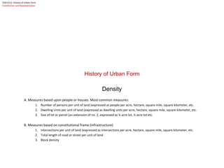
  • 1. History of Urban Form Density A. Measures based upon people or houses. Most common measures: 1. Number of persons per unit of land (expressed as people per acre, hectare, square mile, square kilometer, etc. 2. Dwelling Units per unit of land (expressed as dwelling units per acre, hectare, square mile, square kilometer, etc. 3. Size of lot or parcel (an extension of no. 2, expressed as ¼ acre lot, ½ acre lot etc. B. Measures based on constitutional frame (infrastructure) 1. Intersections per unit of land (expressed as intersections per acre, hectare, square mile, square kilometer, etc. 2. Total length of road or street per unit of land 3. Block density COA 6151: History of Urban Form Constitution and Representation
  • 2. COA 6151: History of Urban Form Constitution and Representation
  • 3. Housing Unit Density by Distance from the city's CBD 0 3 6 9 12 15 18 21 24 27 1 3 5 7 9 11 13 15 17 19 21 23 25 27 29 31 33 35 37 39 41 43 45 47 49 51 Distance (Miles) HU/Acre Atlanta Chicago New York Density Gradients for Three Metro Areas COA 6151: History of Urban Form Constitution and Representation
  • 4. Observation: Since 1928, Block sizes have increased by a factor of 3.2 from the average block size prior to 1928. Pre 1928 Block Size Post 1928 Block Size avg. max avg max acres acres acres acres 1 Atlanta, GA 3.70 8.26 1 Atlanta, GA 22.87 44.49 2 Boston, MA 3.09 4.13 2 Boston, MA 9.45 14.46 3 Baltimore, Md 3.29 5.78 3 Baltimore, Md 14.93 22.72 4 Charleston, S.C. 4.12 6.07 4 Charleston, S.C. 16.89 25.25 5 Chicago, Illinois 3.51 4.96 5 Chicago, Illinois 14.74 19.10 6 Los Angeles, CA 4.41 7.89 6 Los Angeles, CA 8.01 16.08 7 New York, N.Y. (Manhattan) 2.60 3.67 7 New York, N.Y. (Manhattan) 7.72 13.31 8 Omaha, Nebraska 4.34 8.26 8 Omaha, Nebraska 8.27 13.42 9 Portland, Oregon 1.92 3.72 9 Portland, Oregon 2.69 4.24 10 Philadelphia, Pennsylvania 3.07 6.33 10 Philadelphia, Pennsylvania 5.03 5.88 Average 3.41 5.91 11.06 17.90 Median 3.40 5.93 8.86 15.27 Std. Dev 0.79 1.80 6.14 11.42 COA 6151: History of Urban Form Constitution and Representation
  • 5. Observation 2: the standard deviation of average block size in the following selected cities has increased from .79 to 6.14 from pre-1928 subdivision to post -1928 subdivision. Pre 1928 Block Size Post 1928 Block Size avg. max avg max acres acres acres acres 1 Atlanta, GA 3.70 8.26 1 Atlanta, GA 22.87 44.49 2 Boston, MA 3.09 4.13 2 Boston, MA 9.45 14.46 3 Baltimore, Md 3.29 5.78 3 Baltimore, Md 14.93 22.72 4 Charleston, S.C. 4.12 6.07 4 Charleston, S.C. 16.89 25.25 5 Chicago, Illinois 3.51 4.96 5 Chicago, Illinois 14.74 19.10 6 Los Angeles, CA 4.41 7.89 6 Los Angeles, CA 8.01 16.08 7 New York, N.Y. (Manhattan) 2.60 3.67 7 New York, N.Y. (Manhattan) 7.72 13.31 8 Omaha, Nebraska 4.34 8.26 8 Omaha, Nebraska 8.27 13.42 9 Portland, Oregon 1.92 3.72 9 Portland, Oregon 2.69 4.24 10 Philadelphia, Pennsylvania 3.07 6.33 10 Philadelphia, Pennsylvania 5.03 5.88 Average 3.41 5.91 11.06 17.90 Median 3.40 5.93 8.86 15.27 Std. Dev 0.79 1.80 6.14 11.42 COA 6151: History of Urban Form Constitution and Representation
  • 6. COA 6151: History of Urban Form Constitution and Representation Street and block density Clockwise from upper left • Paris • Brasilia • Istanbul • Atlanta
  • 7. History of Urban Form Form Structure of Streets and Blocks . COA 6151: History of Urban Form Constitution and Representation
  • 8. Morphological (Form) COMPARISON B L O C K D E N D R I T I C COA 6151: History of Urban Form Constitution and Representation
  • 9. Morphological (Form) COMPARISON PUBLIC SPACE B L O C K D E N D R I T I C COA 6151: History of Urban Form Constitution and Representation
  • 10. Morphological (Form) COMPARISON GROWTH COA 6151: History of Urban Form Constitution and Representation
  • 11. Morphological (Form) COMPARISON Baghdad: Historic Center c. 1400 AD Dendritic System of streets within larger “super blocks" Baghdad: early 20th century suburb Striated Blocks with superimposed radial avenues COA 6151: History of Urban Form Constitution and Representation
  • 12. Morphological (Form) COMPARISON Atlanta: Historic Center c. 1840 Block with rotated grid Atlanta: Midtown / early 20th c. suburb c. 1900 Deformed Block with rotated grid COA 6151: History of Urban Form Constitution and Representation
  • 13. Morphological (Form) COMPARISON Atlanta: Late 20th c. suburb Dendritic Pattern with “super block” Baghdad: Historic Center c. 1400 AD Dendritic System of streets within larger “super blocks" COA 6151: History of Urban Form Constitution and Representation
  • 14. Assur c. 1200 BCE Damascus: Old City as shown c. 800 AD Philadelphia: 1685 AD 3130'190' 170' 1240' 1370' 1680' 460' 700' 2780' 1530' 5520' 6770' 7540' 690' 2150' 1970' 2640' 1730' 790' 1280' Windward (Atlanta) 1985 AD COA 6151: History of Urban Form Constitution and Representation
  • 15. COA 6151 ARCH 4151 The History of Urban Form Lecture 02: Origins of the City: Orient and Occident COA 6151: History of Urban Form Origins of the City
  • 16. Origins of the City Eastern Mediterranean to the Iranian Plateau COA 6151: History of Urban Form Origins of the City HORSES CATTLE GOATS SHEEP HORSES: Steppes, Ukraine and Southern Russia CATTLE: Northern India, Indus Valley GOATS: Northern Iran, Iraq, Kurdistan SHEEP: Northern Iran, Kurdistan, and Mesopotamia SHEEP GOATS GOATS
  • 17. Origins of the City Eastern Mediterranean to the Iranian Plateau 7,000 BCE Catal Huyuk 9,000 BCE Jericho 4,000 BCE 4,000 BCE Ur Uruk 3,000 BCE COA 6151: History of Urban Form Origins of the City 9,000 BCE Gobekli Tepe Permanent human settlements, Neolithic period Cities and proto-cites.
  • 18. COA 6151 ARCH 4151 The History of Urban Form Jericho: 8000 – 3000 BCE COA 6151: History of Urban Form Origins of the City
  • 19. Arch 4151: History of Urban Form Georgia Institute of Technology College of Architecture Origins of the City Jericho Jericho: Tell or mound at the site of the original city dating to 8000 BCE. Settlement at Jericho (Jerich or Tel-es-Sultan) was dated by Kathleen Kenyon to extend to 8000-9000 BCE. Occupation is Generally assigned to three periods prior to the Bronze Age or c. 3000 BCE. 1. Natufian: Proto-Neolithic -- construction at the site apparently began before the invention of agriculture, with construction of stone Natufian culture structures beginning earlier than 9000 BC. 2. PPN A: Pre-Pottery Neolithic A, 8350 BC to 7370 BC. Sometimes called Sultanien. A four hectare settlement surrounded by a stone wall, with a stone tower in the centre of one wall. Round mud- brick houses. Use of domesticated emmer wheat, barley and pulses and hunting of wild animals. 3. PPN B: Pre-Pottery Neolithic B, 7220 BC to 5850 BC (but carbon-14-dates are few and early). Expanded range of domesticated plants. Possible domestication of sheep. Apparent cult involving the preservation of human skulls, with facial features reconstructed from plaster and eyes set with shells in some cases. After the PPN A settlement-phase there was a settlement hiatus of several centuries, then the PPN B settlement was founded on the eroded surface of the tell. The architecture consisted of rectilinear buildings made of mudbricks on stone foundations. The mudbricks were loaf-shaped with deep thumb prints to facilitate bounding. No building has been excavated in its entirety. Normally, several rooms cluster around a central courtyard. There is one big room (6.5 x 4 m and 7 x 3 m) with internal divisions, the rest are small, presumably used for storage. The rooms have red or pinkish terrazzo-floors made of lime. Some impressions of mats made of reeds or rushes have been preserved. The courtyards have clay floors.
  • 20. Arch 4151: History of Urban Form Georgia Institute of Technology College of Architecture Origins of the City Jericho Modern Jericho looking east toward the Jordan Valley from above the Tell Walls datable to the early Bronze Age or Chalcolithic Period, 3300 BCE Excavated by Kathleen Kenyon in the late 1940’s, the material record indicates a substantial break in occupation beginning around 1150 BCE. Modern Jericho dates to the 12th century AD. Although the walls shown here date to a period much later than the Neolithic period, Jericho , along with Catal Huyuk in Turkey can claim the current position as the oldest “cities” in the world. Photo courtesy of the Bryn Mawr Collection
  • 21. Arch 4151: History of Urban Form Georgia Institute of Technology College of Architecture Origins of the City Jericho Chalcolithic Period walls at Jericho c. 3300 BCE Defensive work or tower, Jericho 3300 BCE
  • 22. COA 6151 ARCH 4151 The History of Urban Form Catal Huyuk: 7000 BCE COA 6151: History of Urban Form Origins of the City
  • 23. Arch 4151: History of Urban Form Georgia Institute of Technology College of Architecture Origins of the City Catal Huyuk 7000 BCE
  • 24. Arch 4151: History of Urban Form Georgia Institute of Technology College of Architecture Origins of the City Catal Huyuk c. 7000 BCE
  • 25. Arch 4151: History of Urban Form Georgia Institute of Technology College of Architecture Origins of the City Catal Huyuk c. 7000 BCE
  • 26. Arch 4151: History of Urban Form Georgia Institute of Technology College of Architecture Origins of the City Catal Huyuk c. 7000 BCE
  • 27. Arch 4151: History of Urban Form Georgia Institute of Technology College of Architecture Origins of the City Catal Huyuk c. 7000 BCE
  • 28. Arch 4151: History of Urban Form Georgia Institute of Technology College of Architecture Origins of the City Catal Huyuk c. 7000 BCE
  • 29. COA 6151 ARCH 4151 The History of Urban Form Trade and the Development of Writing 5000 – 3000 BCE COA 6151: History of Urban Form Origins of the City
  • 30. 1000 BCE Bronze Age Copper Age in Niger Bantu expansion Late Bronze Age Early Iron Age Development of Indian Iron Age Chinese Bronze Age 2000 BCE Bell beaker Chalcolithic corded ceramic domestication of the horse Neolithic of Ticht / Tenerean Middle Bronze Age (Sumer) Indus Valley civilization writing Chinese Neolithic of Longshan 3000 BCE enclosed villages first megaliths Chalcolithic of Central Europe Hunter-gatherer art of South Africa Early Bronze Age Regionalization Era 4000 BCE Lower Neolithic Danubian Neolithic Writing Mediterranean and Egyptian Neolithic Neolithic in East Africa Writing Uruk period Chalcolithic (copper metallurgy) Writing Mehrgarh Indus Valley Writing Neolithic of Yang-Shao rice-growing (?) 5000 BCE Cardial and Linear Pottery (agriculture, stock- rearing, Pottery) Tardenoisian cultures Starčevo and Vinča culture agriculture, stock-rearing (pigs, bovine, sheep) Neolithic of the Sahara/Sahel Ubaid period ceramic ware Cyprus Mehrgarh Hongshan culture of Northeast Asia (ca. 4700 BC/6700 BP) 7000 BCE Sauveterrian cultures (gathering of legumes) Neolithic (Greece and the Eastern Mediterranean ) Sesklo and Choirokoitia Neolithic with ceramic Ubaid period Mehrgarh Neolithic of northern China 8000 BCE Backed point culture Wiltonian Pre-ceramic B Pre-ceramic A Neolithic in Turkey (wheat, barley) hunter gatherers of Jōmon (ancient Japan) TIME Europe North Africa, West Africa and Sahara Central Africa, South and East Africa Middle East South Asia, and Central Asia East Asia and South-East Asia Comparative Time Line
  • 31. Comparative Time Line Writing COA 6151: History of Urban Form Origins of the City
  • 32. Trade : Trade means contact with other people. Along with trade of goods is the need to record inventories, record exchange value, etc. COA 6151: History of Urban Form Origins of the City
  • 33. COA 6151 ARCH 4151 The History of Urban Form Writing and Language Groups 5000 – 3000 BCE COA 6151: History of Urban Form Origins of the City
  • 34. Eastern Mediterranean to the Iranian Plateau 6000-4000 BCE Indo-European Speaking People Semitic Speaking People Around 4,500 years ago. A large migration of language groups occurs. While no evidence of war or other forcible take-over has been found, a sudden revolution in agriculture and language occurs in Europe..Cattle, Sheep, Goats, Pigs, etc. appear. Wheat appears in north Africa and southern Europe. This would indicate the transport of agricultural practices migrating out of two “hearths”, one in Africa, the other in Western Asia. COA 6151: History of Urban Form Origins of the City
  • 35. Origins of the City Areas of Linguistic influence Eastern Mediterranean to the Iranian Plateau S E M I T I C The Semitic family is a member of the larger Afroasiatic family, all of whose other five or more branches are based in Africa. Largely for this reason, the ancestors of Proto-Semitic speakers are believed by many to have first arrived in the Middle East from Africa, possibly as part of the operation of the “Saharan pump”, around the late Neolithic Period. 9500 BC Note: The Saharan Pump refers to the cyclical drying of the Sahara, the last being associated with the recession of the Glacial Ice Age. The theory is that African languages moved northward and became isolated in the Nile Valley, Coastal North Africa, and the Levant (Eastern Mediterranean) around 10-12,000 BC. COA 6151: History of Urban Form Origins of the City
  • 36. I N D O - E U R O P E A N Origins of the City Areas of Linguistic influence Eastern Mediterranean to the Iranian Plateau Around 4500 BCE COA 6151: History of Urban Form Origins of the City
  • 37. I N D O - E U R O P E A N S E M I T I C Directions of Cultural Exchange Areas of Substantial Cultural Interchange Origins of the City Areas of Linguistic influence Eastern Mediterranean to the Iranian Plateau COA 6151: History of Urban Form Origins of the City
  • 38. Eastern Mediterranean to the Iranian Plateau c. 2000 BCE 7,000 BCE 9,000 BCE 4,000 BCE 4,000 BCE 3,000 BCE COA 6151: History of Urban Form Origins of the City Alphabetic writing where a symbol represents a “Phoentic” sound Hieroglyphic writing where a symbol represents a word, or multiple words. Cuneiform writing where multiple lines and dots represent highly stylized pictographs, representing both words and numbers, grouped as concepts. These later transformed into syllable sounds .
  • 39. Semitic Modern Indo-European: Greek, Latin Based, (Romance) Celtic, Germanic, Hindi, Farsi, Indo-European Father: Pater, Pita, Pedar Mother: Mater, Matar Sky: Akasa Heart: Kart Foot: Pad, Ped King: Rex, Rix, Raj Modern Semitic: Arabic Hebrew Geʕez (Ethiopian) Amharic Semitic Father: Ab, Abt , Abba Mother: Umm, Ima, (ee-ma) Sky: Samaa , Heart: Alb, Elb, Lev Foot: Regel, Regl King: Malek, Malik, Melech Indo-European COA 6151: History of Urban Form Origins of the City
  • 40. Origins of the City Eastern Mediterranean to the Iranian Plateau I N D O - E U R O P E A N S E M I T I C Catal Huyuk: c. 7000 BCE Jericho c. 8000 BCE Hattusas 3000 BCE Uruk 4000 BCE Ur Directions of Cultural Exchange Areas of Substantial Cultural Interchange COA 6151: History of Urban Form Origins of the City
  • 41. COA 6151 ARCH 4151 The History of Urban Form Uruk and Ur: 4000 – 2000 BCE COA 6151: History of Urban Form Origins of the City
  • 42. Origins of the City Mesopotamia Uruk c. 4000 BCE COA 6151: History of Urban Form Origins of the City
  • 43. Origins of the City Mesopotamia Uruk Mounds formed in braided river deltas after the recession of the Ice in approximately 9,000-10,000 BCE. Cultivation of grasses (wheat, barley, rye) began in the semi-dry areas between the Tigris and Euphrates. Urban civilization appears here around 6000 BCE. Writing appears about 3500, BCE Uruk, one of the oldest settlements dates to about 4000 BCE. COA 6151: History of Urban Form Origins of the City
  • 44. Origins of the City Mesopotamia Ur c. 4000 BCE COA 6151: History of Urban Form Origins of the City
  • 45. Origins of the City Mesopotamia Ur c. 4000 BCE COA 6151: History of Urban Form Origins of the City
  • 46. Origins of the City Mesopotamia UR COA 6151: History of Urban Form Origins of the City
  • 47. Origins of the City Mesopotamia UR Tomb Citadel / Ziggurat Residential Blocks COA 6151: History of Urban Form Origins of the City
  • 48. Origins of the City Mesopotamia Uruk c. 3000 BCE Reconstruction of Temple Complex COA 6151: History of Urban Form Origins of the City
  • 49. Origins of the City Mesopotamia LARSA; Residential buildings grouped around courtyards. This ancient house type will form the basis of residential architecture in the Mediterranean. Egyptian Houses of similar age were frontal. That is, they opened onto a “front” garden or yard. (See Tel el-Amarna) COA 6151: History of Urban Form Origins of the City
  • 50. Origins of the City Mesopotamia Assur c. 1200 BCE COA 6151: History of Urban Form Origins of the City
  • 51. Origins of the City Mesopotamia UR UR: The numbers represent how many rooms distant from the street COA 6151: History of Urban Form Origins of the City
  • 52. Origins of the City Mesopotamia UR UR: The numbers represent how many rooms distant from the street Shops and markets (retail) School Residential Religious Land Use COA 6151: History of Urban Form Origins of the City
  • 53. Origins of the City BAM, Iran The Holy City of Bam, one of the best preserved medieval cities in the world was destroyed by an earthquake recently. Although Bam is much more recent, the formal attributes are similar to the cities of ancient Anatolia and Mesopotamia. Note the clearly defined citadel on the promontory and a secondary defense wall enclosing the valley below. COA 6151: History of Urban Form Origins of the City
  • 54. COA 6151 ARCH 4151 The History of Urban Form Egypt: 4000 – 1000 BCE El Amarna: 1350 BCE COA 6151: History of Urban Form Origins of the City
  • 55. Origins of the City Egypt 4000-1000 BCE Pharaonic Egypt 4500-300 BCE Urbanization in Egypt took a different form than that of either Harrapa or the ancient Mesopotamian civilizations. Perhaps because of the Nile itself, a long thin band of fertile land isolated by the desert, Egypt was relatively secure from foreign invasion. Unified settlements under Pharaonic control and a unified religion were distributed along the Nile Valley from the Delta to the land of “Kush”, ancient Nubia, (present day Sudan) COA 6151: History of Urban Form Origins of the City
  • 56. Origins of the City Egypt Giza Workers Village Dr. Mark Lehner of Harvard University working with famed Egyptian Archaeologist Dr. Zahi Hawass has recently excavated the workers settlement on the plain of Giza, near the great pyramid complex. These excavations have substantially altered our thinking about the construction of the Pyramid / Sphinx complex at Giza, particularly in relation to the belief that these monuments were constructed by slave labor. Instead, the town that supported the construction appears to have been stratified into an artisan section, a royal or dynastic section, and a worker section. The worker section is of particular interest as the sleeping arrangements were communal. Organized like a large house, the “bedrooms” were actually long porches or loggias. Large kitchens, dining halls, baths, etc. indicate a kind of communal religious organization. Separated from this, another settlement appears to have housed the families of the workers along with what could best be described as “middle class” residences. The Great Pyramid is shown under construction. The Sphinx is ghosted-in on the plateau overlooking an artificial harbor. The urban complex is shown in the lower center of the drawing and the worker’s village is directly behind the construction site between the two pyramids. Drawing by M. Lehner, Harvard Magazine, p.47 COA 6151: History of Urban Form Origins of the City
  • 57. Origins of the City Egypt Giza In short, Lehner and Hawass have developed a working hypothesis that the Pyramids, in a sense, built Egypt, and not the other way around. Put another way, a similar phenomenon appears in Florence in the Renaissance, with the construction of the Duomo at Santa Maria del Fiore. Brunelleschi design was so complex, requiring the complete re-organization of labor, the development of new machines for hauling equipment and material, that it produced, in effect, a kind of school for artisans. Taken together with the financial organization and systems organization, the Duomo, in a very real sense, built the renaissance. Could the same be said for early Pharaonic Egypt? Possibly so. The two great pyramids loom in the background over Lehner and Hawass’ “Millennium Dig”. In the upper middle is the wall of the residential compound, between the vegetation and the van, appearing as a stone ridge. The individual houses and blocks are in the foreground. COA 6151: History of Urban Form Origins of the City
  • 58. Origins of the City Egypt Giza Workers “dormitory” COA 6151: History of Urban Form Origins of the City
  • 59. Origins of the City Egypt Amarna Complex c. 1300 BCE Unlike its Mesopotamian or Hittite counter-parts, the Egyptian City tended to consist of a series of related parts, distributed over a relatively large area, all of which faced the Nile. Such a distributed form can be explained by the dependence of Egyptian Civilization, then as now, upon the flood plain of the River. With the desert acting as an almost impenetrable barrier, defensive walls were not as critical. Though walls most certainly existed for other reasons. Rather, the urban component tended to cluster at the juncture between the arable land associated with the flood plain and the river terrace at the edge of the arid, non-arable land; the fertile land being subject to flood as well as too valuable to build on. The Royal; compound, complete with Akhenaton's Temple believed to have been dedicated to Atun-Ra lies in the center. The cluster of blocks just above it is a residential quarter divided by a large street. A second palace appears to the north of that. Areas in between have yet to be fully excavated. While the evidence is thin, it is expected that future excavations will reveal that this is a complex urban pattern divided similarly to Giza, into precincts associated with both land use (residential vs. religious) as well as by type of people (artisan vs. worker, etc.) To the south of the dynastic compound is a walled city arranged in a pattern not unlike the fragment immediately to the north of the Great Temple, but with larger volumes of space implied in the remains of the walls. Most of this area is unexcavated. In between, there is evidence of cultivate plots, irrigated by T-canals branching from the Nile. Again, the significance of this model lies in stark contrast to almost all other urban forms in the ancient world. As such, the Egyptian patterns would not, in their entirety, exert much influence outside of Egypt. Taken as individualized organization schemes, however, it would appear that the internal organization of streets and regularized blocks possibly found its way northward into the Mediterranean where it exerted some influence over Minoan palace compounds and support cities on Crete. COA 6151: History of Urban Form Origins of the City
  • 60. Origins of the City Egypt Amarna Complex COA 6151: History of Urban Form Origins of the City
  • 61. Origins of the City Egypt Amarna Complex B COA 6151: History of Urban Form Origins of the City
  • 62. Origins of the City Egypt Amarna Complex C COA 6151: History of Urban Form Origins of the City
  • 63. Origins of the City Egypt Kahun Housing Quarters with Market (A)? (A) COA 6151: History of Urban Form Origins of the City
  • 64. COA 6151 ARCH 4151 The History of Urban Form Indus Valley Mohenjo-Daro- c. 2500 BCE COA 6151: History of Urban Form Origins of the City
  • 65. Origins of the City: Harrapan Civilization COA 6151: History of Urban Form Origins of the City
  • 66. Origins of the City INDUS VALLEY Harrapa and Mohenjo-Daro, c. 2500 BCE The Indus Civilization, also called the Harappan Civilization [1], flourished about four thousand years ago in the north-western parts of India and Pakistan along the valley of the Indus River, the main river of the region. However, as was discovered later on, the civilization extended far beyond the limits of the valley — from Sutkagen-dor of south Baluchistan in the west to Alamgirpur of Uttar Pradesh in the east; and from Raopur upon the sub-Himalayan foothills in the north to Bhagatrav on the estuary of the Kim in the south (Fig. 1). In other words, the Indus Valley Civilization covered an area of 1000miles from west to east, and about 700miles from north to south; and it will not be surprising if future discoveries widen the horizons of the civilization still further (Lal, 1975). This is an area much greater than that jointly occupied by its contemporary Egyptian and Mesopotamian Civilizations (Lal, 1975), and considerably larger than modern Pakistan (Bridget and Raymond Allchin, 1982; 167). At present, about 1000 sites have been identified that belonged to the different phases of the Indus Civilization (Rao, 1991). Previously, scholars held the opinion that the contribution of the Indus Civilization was insignificant to the history of civilization, and that the Harappan Civilization was an isolated phenomenon (Wheeler, 1968). However, Piggot (1950), McCown (1957), Vats (1974), Sankalia (1974), Allchin (1982) and others have quite reasonably established its connections with other contemporary civilizations (Rao, 1991) of the region. However, as was discovered later on, the civilization extended far beyond the limits of the valley — from Sutkagen-dor of south Baluchistan in the west to Alamgirpur of Uttar Pradesh in the east; and from Raopur upon the sub-Himalayan foothills in the north to Bhagatrav on the estuary of the Kim in the south (Fig. 1). In other words, the Indus Valley Civilization covered an area of 1000miles from west to east, and about 700miles from north to south; and it will not be surprising if future discoveries widen the horizons of the civilization still further (Lal, 1975). This is an area much greater than that jointly occupied by its contemporary Egyptian and Mesopotamian Civilizations (Lal, 1975), and considerably larger than modern Pakistan (Bridget and Raymond Allchin, 1982; 167). At present, about 1000 sites have been identified that belonged to the different phases of the Indus Civilization (Rao, 1991). Previously, scholars held the opinion that the contribution of the Indus Civilization was insignificant to the history of civilization, and that the Harappan Civilization was an isolated phenomenon (Wheeler, 1968). However, Piggot (1950), McCown (1957), Vats (1974), Sankalia (1974), Allchin (1982) and others have quite reasonably established its connections with other contemporary civilizations (Rao, 1991). The Indus Civilization was an urban civilization. Harappa and Mohenjo-daro were probably the largest Harappan cities. The found artifacts of the excavation sites show that these cities might have a capacity to have a wide habitational spectrum.[2] All these cities were well-planned with neatly laid streets, and some of them supposedly [3]had gridiron layout (Wheeler 1966: 23). They were invariably protected against flood for which burnt bricks played an important role (Bridget and Raymond Allchin, 1982: 167). Though there are some differences in opinions on the planning of the public buildings, like the Granaries (Fentress 1976: 133-83; also see Jansen 1979) in these cities, the overall picture is one of regimentation to some degree. Mahbub Rashid, “The Dimensions of the Harappan City of Mohenjo-daro and Their Possible Relations to the Harappan System of Proportion”, Georgia Institute of Technology, 1995 (1.) According to Gregory L. Possehl (1984), both of these terms, 'Harappan' or 'Indus' as in 'Harappan Civilization' or 'Indus Civilization' can be justified in some ways, neither of them is without its shortcomings. He writes, "For example, the very notion of the 'Indus Civilization in Saurashtra' is possibly out of place given the fact that Saurashtra is reasonably beyond the geographic bounds of the Indus Valley, as are Haryana, Indian Punjab and Western Uttar Pradesh — other regions within which 'Indus' remains have been found. But when John Marshall coined the term, I suspect that he was reacting against the even more parochial character of the concept of an 'Harappan Civilization' and found that the larger geographic context of the greater Indus riverine system was simply more appropriate" (Possehl, 1984). [2] Lambrick has made a convincing case for a figure of 35,000 at Mohenjo-daro, based upon comparison with the population of a city of comparable area in Sind in 1841. An independent estimate by Fairservis suggests a slightly higher figure of 41,000. As Harappa appears to have been of roughly equivalent size, its population may well have been more or less the same, but Fairservis has suggested a figure of 23,500 for the lower city of Harappa, excluding the citadel (Bridget and Raymond Allchin, 1982: 180). [3]I use supposedly because it is a controversial issue. The earliest deposits on the site go back to 3300 B.C. and the area seems to have been continuously inhabited ever since. Archaeologists think that ancient Harappa was the urban center dominating the upper Indus region, much like Mohenjo-daro dominated the lower Indus Valley and Ganweriwala might have been the urban center for what is now Rajasthan. COA 6151: History of Urban Form Origins of the City
  • 67. Origins of the City INDUS VALLEY Harrapa and Mohenjo-Daro The earliest deposits on the site go back to 3300 B.C. and the area seems to have been continuously inhabited ever since. Archaeologists think that ancient Harappa was the urban center dominating the upper Indus region, much like Mohenjo-daro dominated the lower Indus Valley and Ganweriwala might have been the urban center for what is now Rajasthan. Mohenjo-daro c. 1800 BCE. Entrance Gate at Royal Citadel. COA 6151: History of Urban Form Origins of the City
  • 68. Origins of the City Harrapan Mohenjo-Daro Archaeological map of excavations at Mohenjo-Daro COA 6151: History of Urban Form Origins of the City
  • 69. Origins of the City Harrapan Mohenjo-Daro COA 6151: History of Urban Form Origins of the City
  • 70. Origins of the City Harrapan Mohenjo-Daro Area “HR” Excavated by Wheeler COA 6151: History of Urban Form Origins of the City
  • 71. Origins of the City Harrapan Mohenjo-Daro Abstracted diagram of streets and lanes, showing cellular units of subdivision within the urban structure. From Mahbub Rashid, “The Dimensions of the Harappan City of Mohenjo-daro and Their Possible Relations to the Harappan System of Proportion”, Georgia Institute of Technology, 1995 COA 6151: History of Urban Form Origins of the City
  • 72. Arch 4151: History of Urban Form Georgia Institute of Technology College of Architecture Origins of the City Harrapan Mohenjo-Daro The suggested subdivision pattern of the blocks in the HR area according to the present layout of lanes and streets in the area. Dimensions are in English Feet. Rashid, 1996
  • 73. Origins of the City Harrapan Mohenjo-Daro Houses of the HR and VS areas of Mohenjo-daro show that they were built based on a simple system of the multiplication of a basic dimension. COA 6151: History of Urban Form Origins of the City
  • 74. Origins of the City Harrapan Mohenjo-Daro COA 6151: History of Urban Form Origins of the City
  • 75. COA 6151 ARCH 4151 The History of Urban Form Anatolia Hittite c. 2500-1000 BCE COA 6151: History of Urban Form Origins of the City
  • 76. Origins of the City: Hattusas (Hittite) COA 6151: History of Urban Form Origins of the City
  • 77. Origins of the City Hattusas c. 6000 -1200 BCE c. 3000 BCE The early settlers of Hattusas spoke a language with the same name. It belongs to no other known family and scholars call it Hattic to distinguish it from Hittite. Hittite is an Indo-European language and probably arrived with Indo-European conquerors, although details of this "conquest" are lacking. Indo-European names appear at Kanesh before 1850 BCE, and it is possible that the native Hattic people made up the ruling class or even the entire population during this period, but this cannot be proven. COA 6151: History of Urban Form Origins of the City
  • 78. Origins of the City Hattusas c. 3000 -1200 BCE c. 3000-2000 BCE c. 2000-1400 BCE COA 6151: History of Urban Form Origins of the City
  • 79. Origins of the City Hattusas c. 3000 -1200 BCE c. 2000-1400 BCE c. 3000-2000 BCE c. 1400-1100 BCE The first writing from the site are clay tablets with Old Assyrian cuneiform. These demonstrate the presence of Assyrian merchants at the city, then called Hattus, around 1800 BCE. The largest Assyrian trading center in Anatolia was at Kanesh, which flourished from 1950 BCE to 1850 BCE (end of First Intermediate Period and beginning of Twelfth Dynasty), was destroyed, and then became active again around 1820 BCE and lasted another two generations (late 12th Dynasty). Assyrian trading at Hattusas is contemporary only with the later period. The merchants lived in the lower part of the city, which extended up to the great hill, whereupon the king's palace was probably located. The entire city was destroyed, probably by a King Anittas of Kussara sometime after 1800 BCE. A Hittite text supposed to have been written by him describes his conquests in Anatolia, noting he destroyed Hattusas, killed its King Piyusti, and cursed the city's site. COA 6151: History of Urban Form Origins of the City
  • 80. Origins of the City Hattussas (Htattush) c. 3000 -1000 BCE Catal Huyuk ? COA 6151: History of Urban Form Origins of the City
  • 81. Crete c. 2000 BCE Origins of the City Eastern Mediterranean COA 6151: History of Urban Form Origins of the City
  • 82. Crete c. 2000 BCE Origins of the City Eastern Mediterranean COA 6151: History of Urban Form Origins of the City
  • 83. Crete c. 2000 BCE Origins of the City Eastern Mediterranean COA 6151: History of Urban Form Origins of the City
  • 84. Crete c. 2000 BCE Origins of the City Eastern Mediterranean COA 6151: History of Urban Form Origins of the City