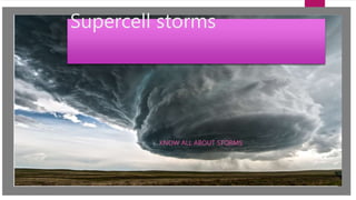
A supercell storm is a thunderstorm with a deep, persistently rotating updraft called a mesocyclone. They can trigger tornadoes and are characterized by cumulonimbus clouds in the middle. At the top is an anvil region which can produce damaging lightning strikes. The first storm identified as a supercell was the Wokingham storm over England in 1962.
2. WHAT ARE SUPERCELL STORMS?
We define a supercell as a thunderstorm with a deep rotating updraft
(mesocyclone). In fact, the major difference between supercell and
multicell storms is the element of rotation in supercells. As we shall see,
circumstances keep some supercells from producing tornadoes, even with the
presence of a mesocyclone.
3. APPEARANCE
A supercell is a thunderstorm characterized by the presence of a mesocyclone: a deep,
persistently rotating updraft.[1] For this reason, these storms are sometimes referred to
as rotating thunderstorms.[2] Of the four classifications of thunderstorms (supercell, squall
line, multi-cell, and single-cell), supercells are the overall least common and have the potential
to be the most severe. Supercells are often isolated from other thunderstorms, and can
dominate the local weather up to 32 kilometres (20 mi) away. They tend to last 2-4 hours.
Supercells are often put into three classification types: Classic, Low-precipitation (LP), and
High-precipitation (HP). LP supercells are usually found in climates that are more arid, such as
the high plains of the United States, and HP supercells are most often found in moist climates.
Supercells can occur anywhere in the world under the right pre-existing weather conditions,
but they are most common in the Great Plains of the United States in an area known
as Tornado Alley and in the Tornado Corridor of Argentina, Uruguay and southern Brazil.
4. How is it formed?
A supercell requires several very unique factors coming together in order to see them form. All
thunderstorms require three ingredients to form: moisture, instability, and lift. Supercells, on the
other hand, require all three of those plus an additional factor: wind shear.
5. History of supercell storms
Supercells can occur anywhere in the world under the right weather conditions. The
first storm to be identified as the supercell type was the Wokingham storm
over England, which was studied by Keith Browning and Frank Ludlam in
1962.[4] Browning did the initial work that was followed up by Lemon and Do swell to
develop the modern conceptual model of the supercell.[5] To the extent that records
are available, supercells are most frequent in the Great Plains of the central United
States and southern Canada extending into the south eastern U.S. and
northern Mexico; east-central Argentina and adjacent regions of Uruguay; Bangladesh
and parts of eastern India; South Africa; and eastern Australia.[6] Supercells occur
occasionally in many other mid-latitude regions, including Eastern China and
throughout Europe. The areas with highest frequencies of supercells are similar to
those with the most occurrences of tornadoes; see tornado climatology and Tornado
Alley.
6. HOW BIG ARE THEY?
The high shear causes horizontal vorticity which is tilted within the updraft to
become vertical vorticity, and the mass of clouds spins as it gains altitude up to
the cap, which can be up to the 55,000 feet (17,000 m)–70,000 feet (21,000 m)
7. WHAT DO THEY TRIGGER?
They trigger tornadoes also included in this lecture is information on supercell
thunderstorms and vertical wind shear. Several ingredients are required to form
a supercell thunderstorm. The first is a trigger to get the air to rise. Most often
the trigger is upper-level divergence on the east side of a trough. And is thought often
to be in the mid-west united states of America.
8. What clouds are in the middle? You have 1min
The clouds in the middle are Cumulonimbus, from the Latin cumulus ("heaped") and nimbus
("rainstorm"), is a dense, towering vertical cloud[1], forming from water vapour carried by
powerful upward air currents. If observed during a storm, these clouds may be referred to as
thunderheads. Cumulonimbus can form alone, in clusters, or along cold front squall lines.
These clouds are capable of producing lightning and other dangerous severe weather, such
as tornadoes. Cumulonimbus progress from overdeveloped cumulus congest us clouds and
may further develop as part of a supercell. Cumulonimbus is abbreviated Cb.
9. What is an anvil at the top of a supercell?
The anvil regions of supercells can produce unexpected and damaging lightning
flashes. It has long been understood that the anvil regions of thunderstorms carry
electric charge (e.g., Standler and Winn 1979; Krehbiel 1986; Marshall et al. 1989),
and the electric field in anvils poses a significant threat for triggering lightning
during space flight operations (Krider et al. 1999). Several studies have measured
electric fields in anvils using either balloon-borne instrumentation (e.g., Byrne et
al. 1989; Marshall et al. 1989) or instrumentation aboard aircraft (e.g., Dye et al.
2007; Dye and Willett 2007). These studies have found that strong electric fields
can persist for many tens of minutes and many tens of kilometres, well
downstream of the parent convection.
10. What was the date when a supercell
storm struck London?
The date was the 7 June 1996.
Editor's Notes
Op power-point!!!!!!!!!!!!!!!!!!!!!!!!!!!!!!!!!!!!!!!!!!!!!!!!!!!!