SlideShare a Scribd company logo
1 of 4
ã2017 California Institute of Technology. Government sponsorship acknowledged.
A new era of earthquake science
Human activity sometimes causes earthquakes –
particularly when large masses of material are moved
from one area to another, or when fluids are extracted or
injected into the subsurface. Impoundment of water on
the surface behind dams, open pit and underground
mining, and wastewater injection have all been linked to
changes in the frequency of regional earthquakes. Some
of these changes, such as those that occur in areas of
geothermal power generation, are subtle, since they
occur in regions that may naturally experience frequent
earthquakes. Others, such as those now occurring in the
central United States, represent a significant change.
Understanding Induced
Earthquakes
Earthquakes are now occurring in areas with little historical seismicity as a
result of activities associated with resource extraction. The NISAR satellite
mission will improve our ability to characterize such induced earthquakes, and
increase our understanding of changing earthquake likelihoods.
The NISAR Mission – Reliable, Consistent Observations
The NASA–ISRO Synthetic Aperture Radar (NISAR) mission, a collaboration between the
National Aeronautics and Space Administration (NASA) and the Indian Space Research
Organization (ISRO), will provide all-weather, day/night imaging of nearly the entire land
and ice masses of the Earth repeated 4-6 times per month. NISAR’s orbiting radars will
image at resolutions of 5-10 meters to identify and track subtle movement of the Earth’s
land and its sea ice, and even provide information about what is happening below the
surface. Its repeated set of high resolution images can inform resource management
and be used to detect small-scale changes before they are visible to the eye. Products
are expected to be available 1-2 days after observation, and within hours in response to
disasters, providing actionable, timely data for many applications.
The changing landscape of earthquake hazards
Over the past several decades, the number of earthquakes observed in the
central and eastern United States has jumped dramatically, from an average
of 21 earthquakes per year with magnitude three or larger from 1973 to
2008, up to 659 in 2014. The increase is strongest in areas that also saw a
strong upward trend in the volume of wastewater injected into the
subsurface.
Observations of how the ground surface rises or falls during an earthquake
allow scientists to determine where the earthquake occurred, how deep and
large it was, and whether there is evidence of additional motion that
occurred more slowly before or after the event.
Image (clockwise): USGS, USBR (CC BY-SA 2.0), USGS, Ficelloguy/English
Wikipedia (CC BY-SA 3.0)
ã2017 California Institute of Technology. Government sponsorship acknowledged.
Continued from front page
The past decade has seen a substantial increase in
the number of earthquakes triggered by human
activity, particularly the injection and production of
subsurface fluids associated with hydrocarbon
production. Oklahoma now experiences more
earthquakes each year than California. Efforts to
reduce our society’s reliance on fossil fuels also
compound the problem, with increases in
earthquake frequency associated with energy
production at geothermal power plants and at large
dams that contribute hydrothermal power to the
electricity grid.
The increased frequency of earthquakes in regions
such as the central United States create new
challenges, particularly since the energy and
resource needs of our population are likely to
continue to grow. Even forecasting the expected
damage from these new types of earthquakes is not
just “business as usual.” Analyses of shaking reports
from the central United States suggest that the
distribution of damage from these earthquakes,
which tend to be shallower and could have more
involvement from fluids within the rock, are different
from the damage expected from “traditional”
earthquakes, which often occur deep underground.
Precise estimates of the location and timing of these
earthquakes are needed to characterize how they
interact with each other and with the perturbations
to the subsurface that are driving them.
The upcoming NISAR radar mission includes a
dependable, regular observation plan that will collect
high resolution images over 90% of the Earth’s land
surfaces at weekly intervals. NISAR’s focus on regular
and repeated observations contrasts with that of
existing satellite synthetic aperture radars, which
typically focus only on areas of interest to a specific
government or scientific agency. This leaves out
much of the United States, because none of the other
radars are U.S. missions. For instance, the central
and eastern United States was not observed
frequently, if at all, by most previous missions. The
observations made over the lifetime of NISAR will be
a giant step forward in our understanding of induced
seismicity, and will inform the next generation of
methods for characterizing and managing these
hazards.
Number of earthquake sequences each year that contain at least
one magnitude 3 or larger earthquake, since 1973, for California
(light blue) and Oklahoma (dark blue). From McGarr et al., 2015,
in the journal Science.
Recent advances in the technology used in hydrocarbon production,
including enhanced oil recovery and increases in the volume of
wastewater injected into the subsurface, are associated with a
dramatic increase in earthquakes felt in the central United States
since the mid-2000’s. Damaging earthquakes only appear to be
related to a small fraction of wells, but there is not yet enough data
to definitively determine in advance the safety of operations at a
particular site.
Earthquake locations derived from seismic data (see figure at left)
illuminate part of the picture – new research shows that induced
earthquakes may behave in slightly different ways than “natural”
events, providing a potential pathway to better understanding and
management. However, seismic data is blind to the slow, longer
term deformation of the ground surface associated with pumping,
injection and even incipient creep on faults that will eventually
rupture in a more damaging earthquake. NISAR can provide the
missing link to this puzzle, complementing the available seismic data
and helping to track how patterns of fluid flow beneath the surface
relate to patterns of observed earthquakes.
Increasing rates of earthquakes in
the central United States.
- California
- Oklahoma
ã2017 California Institute of Technology. Government sponsorship acknowledged.
Induced earthquakes imaged from space:
Satellite-based radar imagery, when available, can be
an extraordinary tool for characterizing how the
Earth’s surface warps and deforms before, during,
and after induced earthquakes. However, these
observations cannot be made when the ground
surface changes significantly between image
acquisitions. Growth of crops, tilling of fields, trees
shedding their leaves are all processes that degrade
data quality. The examples of induced earthquakes
in the central United States shown below are cases
where we were fortunate to have data both before
and after the earthquake. Many other earthquakes
in these regions have been impossible to study
because of the complete lack of data before the
event.
This situation can change in the future: NISAR data
would be acquired regularly over the entire United
States, allowing imaging of areas like Oklahoma,
Texas and Kansas that have both active agriculture
and hydrocarbon/water resource development.
Right: Even tiny earthquakes can be imaged when enough data
is available. This image uses data from the European Space
Agency’s TerraSAR-X platform to constrain subsidence of the
ground during a 2013 magnitude 3.2 earthquake within the
Chicago metropolitan area, triggered by a blast at a limestone
quarry. Color indicates displacement of the ground surface
towards or away from the satellite, which was traveling to the
northwest in the direction of the blue arrow and aimed down
towards the Earth in the direction of the red arrow. The observed
displacement shown here tightly constrains the depth of this
earthquake to 700 meters, much shallower than the zone where
“natural” earthquakes occur.
Examples:
Left: NISAR data will permit systematic mapping and monitoring of
earthquakes, even in agriculturally active areas.
In this example, using data from the European Space Agency’s Sentinel-
1a and -1b platforms, we can see several centimeters of displacement
over a 10 km x 10 km region associated with the 2016 magnitude 5.8
Pawnee, Oklahoma, earthquake. The main earthquake location (red
star) and aftershocks (black dots) outline a complicated pattern that
provides insight into the patterns of weakness in the subsurface. Also in
this image (red band on left) is the signature of a large storm that was
present during one of the image acquisitions. When many images are
available, such as would be provided by NISAR, such atmospheric effects
can be averaged out more effectively to determine the true ground
movement.
ã2017 California Institute of Technology. Government sponsorship acknowledged.
For more information:
General introduction:
https://earthquake.usgs.gov/research/induced/
http://nisar.jpl.nasa.gov/
Community reports
Petersen, M.D. et al. (2016), 2016 One-year seismic hazard forecast for the Central and Eastern United
States from induced and natural earthquakes, U.S. Geological Survey Open-File Report 2016-1035,
52 p., doi:10.3133/ofr20161035.
McGarr, A. et al. (2015), Coping with earthquakes induced by fluid injection, Science, 347; doi:
10.1126/science.aaa0494.
National Research Council (2013), Committee on Induced Seismicity Potential in Energy Technologies.
Induced seismicity potential in energy technologies. National Academies Press, 2013.
National Earthquake Resilience: Research, Implementation, and Outreach (2011), National Academies
Press, Washington, D.C.
Relevant scientific papers.
Jha, B., et al. (2015), Reservoir characterization in an underground gas storage field using joint inversion
of flow and geodetic data, Int. J. Numer. Anal. Meth. Geomech, 39, 1619 – 1638.
Yang, Qi., et al. (2015), InSAR monitoring of ground deformation due to CO2 injection at an enhanced oil
recovery site, West Texas, International Journal of Greenhouse Gas Control 41; doi:
10.1016/j.ijggc.2015.06.016.
Hough, S. E. (2015), Shaking intensity from injection-induced versus tectonic earthquakes in the central-
eastern United States, The Leading Edge 34; doi: 10.1190/tle34060690.1.
Keranen, K. M. et al. (2014), Sharp increase in central Oklahoma seismicity since 2008 induced by massive
wastewater injection, Science, 345; doi: 10.1126/science.1255802.
Barnhart, W. et al. (2014), Seismological and geodetic constraints on the 2011 Mw5.3 Trinidad, Colorado
earthquake and induced deformation in the Raton Basin, J. Geophys. Res., 119;
doi:10.1002/2014JB011227.
Ellsworth, W.L. (2013), Injection-induced earthquakes, Science, 341; doi:10.1126/science.1225942.
González, P. J. et al. (2012), The 2011 Lorca earthquake slip distribution controlled by groundwater
crustal unloading, Nature Geoscience, 5; doi:10.1038/ngeo1610.
Ketelaar, V. B. H. (2009), Subsidence due to hydrocarbon production in the Netherlands, In: Satellite
Radar Interferometry: Subsidence Monitoring Techniques, Springer, London, doi:10.1007/978-1-
4020-9428-6_2
National Aeronautics and Space Administration For more information, visit http://nisar.jpl.nasa.gov/applications
Jet Propulsion Laboratory / California Institute of Technology / Pasadena, California / www.jpl.nasa.gov

More Related Content

Similar to NISAR NASA-ISRO Synthetic Aperture Radar (NISAR) Induced Seismicity

NISAR NASA-ISRO Synthetic Aperture Radar (NISAR) Hazards in Texas
NISAR NASA-ISRO Synthetic Aperture Radar (NISAR) Hazards in TexasNISAR NASA-ISRO Synthetic Aperture Radar (NISAR) Hazards in Texas
NISAR NASA-ISRO Synthetic Aperture Radar (NISAR) Hazards in TexasDr. Pankaj Dhussa
 
NISAR NASA-ISRO Synthetic Aperture Radar (NISAR) Hazards in Florida
NISAR NASA-ISRO Synthetic Aperture Radar (NISAR) Hazards in FloridaNISAR NASA-ISRO Synthetic Aperture Radar (NISAR) Hazards in Florida
NISAR NASA-ISRO Synthetic Aperture Radar (NISAR) Hazards in FloridaDr. Pankaj Dhussa
 
NISAR NASA-ISRO Synthetic Aperture Radar (NISAR) Floods
NISAR NASA-ISRO Synthetic Aperture Radar (NISAR) FloodsNISAR NASA-ISRO Synthetic Aperture Radar (NISAR) Floods
NISAR NASA-ISRO Synthetic Aperture Radar (NISAR) FloodsDr. Pankaj Dhussa
 
NISAR NASA-ISRO Synthetic Aperture Radar (NISAR) Damage Mapping
NISAR NASA-ISRO Synthetic Aperture Radar (NISAR) Damage MappingNISAR NASA-ISRO Synthetic Aperture Radar (NISAR) Damage Mapping
NISAR NASA-ISRO Synthetic Aperture Radar (NISAR) Damage MappingDr. Pankaj Dhussa
 
NOAA and NASA Launch New Polar Satellite for Next-Gen Weather Forecasting
NOAA and NASA Launch New Polar Satellite for Next-Gen Weather ForecastingNOAA and NASA Launch New Polar Satellite for Next-Gen Weather Forecasting
NOAA and NASA Launch New Polar Satellite for Next-Gen Weather ForecastingIrene_McNeil
 
Interevent triggering in microseismicity induced by wastewater injection in O...
Interevent triggering in microseismicity induced by wastewater injection in O...Interevent triggering in microseismicity induced by wastewater injection in O...
Interevent triggering in microseismicity induced by wastewater injection in O...Kamran Karimi
 
2 earthquake damage modeling
2 earthquake damage modeling2 earthquake damage modeling
2 earthquake damage modelingreichm
 
Early Prediction of Earthquakes
Early Prediction of EarthquakesEarly Prediction of Earthquakes
Early Prediction of EarthquakesSaquib Ejaz
 
Earthquake and its predictions. by engr. ghulam yasin taunsvi
Earthquake and its predictions. by engr. ghulam yasin taunsviEarthquake and its predictions. by engr. ghulam yasin taunsvi
Earthquake and its predictions. by engr. ghulam yasin taunsviShan Khan
 
Comprehensive Seismic Hazard Review
Comprehensive Seismic Hazard ReviewComprehensive Seismic Hazard Review
Comprehensive Seismic Hazard ReviewJohanna Vaughan
 
3D Seismic Surveys Provide Detailed Insight into Subsurface Geology
3D Seismic Surveys Provide Detailed Insight into Subsurface Geology3D Seismic Surveys Provide Detailed Insight into Subsurface Geology
3D Seismic Surveys Provide Detailed Insight into Subsurface GeologyNorth American Drilling Corporation
 
Collins_et_al_-_Monitoring_shallow_landslides_in_SFB_California
Collins_et_al_-_Monitoring_shallow_landslides_in_SFB_CaliforniaCollins_et_al_-_Monitoring_shallow_landslides_in_SFB_California
Collins_et_al_-_Monitoring_shallow_landslides_in_SFB_CaliforniaMichael Walker Whitman
 
Earthquakes 120813070301-phpapp02
Earthquakes 120813070301-phpapp02Earthquakes 120813070301-phpapp02
Earthquakes 120813070301-phpapp02Saksham Kumar
 

Similar to NISAR NASA-ISRO Synthetic Aperture Radar (NISAR) Induced Seismicity (20)

Earthquakes
EarthquakesEarthquakes
Earthquakes
 
NISAR NASA-ISRO Synthetic Aperture Radar (NISAR) Hazards in Texas
NISAR NASA-ISRO Synthetic Aperture Radar (NISAR) Hazards in TexasNISAR NASA-ISRO Synthetic Aperture Radar (NISAR) Hazards in Texas
NISAR NASA-ISRO Synthetic Aperture Radar (NISAR) Hazards in Texas
 
NISAR NASA-ISRO Synthetic Aperture Radar (NISAR) Hazards in Florida
NISAR NASA-ISRO Synthetic Aperture Radar (NISAR) Hazards in FloridaNISAR NASA-ISRO Synthetic Aperture Radar (NISAR) Hazards in Florida
NISAR NASA-ISRO Synthetic Aperture Radar (NISAR) Hazards in Florida
 
Earthquake mixon
Earthquake mixonEarthquake mixon
Earthquake mixon
 
NISAR NASA-ISRO Synthetic Aperture Radar (NISAR) Floods
NISAR NASA-ISRO Synthetic Aperture Radar (NISAR) FloodsNISAR NASA-ISRO Synthetic Aperture Radar (NISAR) Floods
NISAR NASA-ISRO Synthetic Aperture Radar (NISAR) Floods
 
NISAR NASA-ISRO Synthetic Aperture Radar (NISAR) Damage Mapping
NISAR NASA-ISRO Synthetic Aperture Radar (NISAR) Damage MappingNISAR NASA-ISRO Synthetic Aperture Radar (NISAR) Damage Mapping
NISAR NASA-ISRO Synthetic Aperture Radar (NISAR) Damage Mapping
 
Conclusive Results
Conclusive ResultsConclusive Results
Conclusive Results
 
WFZ Abstract
WFZ AbstractWFZ Abstract
WFZ Abstract
 
NOAA and NASA Launch New Polar Satellite for Next-Gen Weather Forecasting
NOAA and NASA Launch New Polar Satellite for Next-Gen Weather ForecastingNOAA and NASA Launch New Polar Satellite for Next-Gen Weather Forecasting
NOAA and NASA Launch New Polar Satellite for Next-Gen Weather Forecasting
 
NASA EarthDay 2023
NASA EarthDay 2023NASA EarthDay 2023
NASA EarthDay 2023
 
Discover the world around you.
Discover the world around you.Discover the world around you.
Discover the world around you.
 
AGU_2015
AGU_2015AGU_2015
AGU_2015
 
Interevent triggering in microseismicity induced by wastewater injection in O...
Interevent triggering in microseismicity induced by wastewater injection in O...Interevent triggering in microseismicity induced by wastewater injection in O...
Interevent triggering in microseismicity induced by wastewater injection in O...
 
2 earthquake damage modeling
2 earthquake damage modeling2 earthquake damage modeling
2 earthquake damage modeling
 
Early Prediction of Earthquakes
Early Prediction of EarthquakesEarly Prediction of Earthquakes
Early Prediction of Earthquakes
 
Earthquake and its predictions. by engr. ghulam yasin taunsvi
Earthquake and its predictions. by engr. ghulam yasin taunsviEarthquake and its predictions. by engr. ghulam yasin taunsvi
Earthquake and its predictions. by engr. ghulam yasin taunsvi
 
Comprehensive Seismic Hazard Review
Comprehensive Seismic Hazard ReviewComprehensive Seismic Hazard Review
Comprehensive Seismic Hazard Review
 
3D Seismic Surveys Provide Detailed Insight into Subsurface Geology
3D Seismic Surveys Provide Detailed Insight into Subsurface Geology3D Seismic Surveys Provide Detailed Insight into Subsurface Geology
3D Seismic Surveys Provide Detailed Insight into Subsurface Geology
 
Collins_et_al_-_Monitoring_shallow_landslides_in_SFB_California
Collins_et_al_-_Monitoring_shallow_landslides_in_SFB_CaliforniaCollins_et_al_-_Monitoring_shallow_landslides_in_SFB_California
Collins_et_al_-_Monitoring_shallow_landslides_in_SFB_California
 
Earthquakes 120813070301-phpapp02
Earthquakes 120813070301-phpapp02Earthquakes 120813070301-phpapp02
Earthquakes 120813070301-phpapp02
 

More from Dr. Pankaj Dhussa

NASA Public Perception: Community Response to X-59 Quesst Mission: Phase 3
NASA Public Perception: Community Response to X-59 Quesst Mission: Phase 3NASA Public Perception: Community Response to X-59 Quesst Mission: Phase 3
NASA Public Perception: Community Response to X-59 Quesst Mission: Phase 3Dr. Pankaj Dhussa
 
NASA Overcoming the 50-Year Ban History of the Ban on Commercial Supersonic F...
NASA Overcoming the 50-Year Ban History of the Ban on Commercial Supersonic F...NASA Overcoming the 50-Year Ban History of the Ban on Commercial Supersonic F...
NASA Overcoming the 50-Year Ban History of the Ban on Commercial Supersonic F...Dr. Pankaj Dhussa
 
NASA Flight Demonstration and Capabilities Quesst Phase 3 Flight Operations
NASA Flight Demonstration and Capabilities Quesst Phase 3 Flight OperationsNASA Flight Demonstration and Capabilities Quesst Phase 3 Flight Operations
NASA Flight Demonstration and Capabilities Quesst Phase 3 Flight OperationsDr. Pankaj Dhussa
 
NASA Carbon Fiber Composites (CFC) Recycling Technology Enabled by the TuFF T...
NASA Carbon Fiber Composites (CFC) Recycling Technology Enabled by the TuFF T...NASA Carbon Fiber Composites (CFC) Recycling Technology Enabled by the TuFF T...
NASA Carbon Fiber Composites (CFC) Recycling Technology Enabled by the TuFF T...Dr. Pankaj Dhussa
 
NASA Urban Air Mobility Fatigue Prediction Aaron Crawford – NASA ULI Innovati...
NASA Urban Air Mobility Fatigue Prediction Aaron Crawford – NASA ULI Innovati...NASA Urban Air Mobility Fatigue Prediction Aaron Crawford – NASA ULI Innovati...
NASA Urban Air Mobility Fatigue Prediction Aaron Crawford – NASA ULI Innovati...Dr. Pankaj Dhussa
 
NASA Automated Repair Approaches for AAM
NASA Automated Repair Approaches for AAMNASA Automated Repair Approaches for AAM
NASA Automated Repair Approaches for AAMDr. Pankaj Dhussa
 
NASA Multiscale Analysis Tool (NASMAT) Robust, Integrated, Physics-based, Non...
NASA Multiscale Analysis Tool (NASMAT) Robust, Integrated, Physics-based, Non...NASA Multiscale Analysis Tool (NASMAT) Robust, Integrated, Physics-based, Non...
NASA Multiscale Analysis Tool (NASMAT) Robust, Integrated, Physics-based, Non...Dr. Pankaj Dhussa
 
NASA Materials Informatics Enables Rapid Materials Discovery
NASA Materials Informatics Enables Rapid Materials DiscoveryNASA Materials Informatics Enables Rapid Materials Discovery
NASA Materials Informatics Enables Rapid Materials DiscoveryDr. Pankaj Dhussa
 
NASA CFD Vision 2030: The Power of Exascale Computing
NASA CFD Vision 2030: The Power of Exascale ComputingNASA CFD Vision 2030: The Power of Exascale Computing
NASA CFD Vision 2030: The Power of Exascale ComputingDr. Pankaj Dhussa
 
NASA High Lift Common Research Model (CRM-HL) Ecosystem
NASA High Lift Common Research Model (CRM-HL) EcosystemNASA High Lift Common Research Model (CRM-HL) Ecosystem
NASA High Lift Common Research Model (CRM-HL) EcosystemDr. Pankaj Dhussa
 
NASA Aviary Open-source software tool for optimizing next-generation aircraft...
NASA Aviary Open-source software tool for optimizing next-generation aircraft...NASA Aviary Open-source software tool for optimizing next-generation aircraft...
NASA Aviary Open-source software tool for optimizing next-generation aircraft...Dr. Pankaj Dhussa
 
NASA Aircraft Certification by Analysis (CbA) 20-year Vision for Virtual Flig...
NASA Aircraft Certification by Analysis (CbA) 20-year Vision for Virtual Flig...NASA Aircraft Certification by Analysis (CbA) 20-year Vision for Virtual Flig...
NASA Aircraft Certification by Analysis (CbA) 20-year Vision for Virtual Flig...Dr. Pankaj Dhussa
 
NASA Self-Aligned Focusing Schlieren (SAFS) Flow Visualization Technique
NASA Self-Aligned Focusing Schlieren (SAFS) Flow Visualization TechniqueNASA Self-Aligned Focusing Schlieren (SAFS) Flow Visualization Technique
NASA Self-Aligned Focusing Schlieren (SAFS) Flow Visualization TechniqueDr. Pankaj Dhussa
 
NASA DECO CAS Research into a New Operating Mode for Digitally Enabled Cooper...
NASA DECO CAS Research into a New Operating Mode for Digitally Enabled Cooper...NASA DECO CAS Research into a New Operating Mode for Digitally Enabled Cooper...
NASA DECO CAS Research into a New Operating Mode for Digitally Enabled Cooper...Dr. Pankaj Dhussa
 
NASA Advanced Exploration of Reliable Operation at low Altitudes: meteorology...
NASA Advanced Exploration of Reliable Operation at low Altitudes: meteorology...NASA Advanced Exploration of Reliable Operation at low Altitudes: meteorology...
NASA Advanced Exploration of Reliable Operation at low Altitudes: meteorology...Dr. Pankaj Dhussa
 
NASA Self-Adaptation of Loosely Coupled Systems across a System of Small Uncr...
NASA Self-Adaptation of Loosely Coupled Systems across a System of Small Uncr...NASA Self-Adaptation of Loosely Coupled Systems across a System of Small Uncr...
NASA Self-Adaptation of Loosely Coupled Systems across a System of Small Uncr...Dr. Pankaj Dhussa
 
NASA Safety Case Approach for Automated Flight Authorization System
NASA Safety Case Approach for Automated Flight Authorization SystemNASA Safety Case Approach for Automated Flight Authorization System
NASA Safety Case Approach for Automated Flight Authorization SystemDr. Pankaj Dhussa
 
NASA RealWindDroneSim (RWDS) Enhancing Simulation Fidelity of small Uncrewed ...
NASA RealWindDroneSim (RWDS) Enhancing Simulation Fidelity of small Uncrewed ...NASA RealWindDroneSim (RWDS) Enhancing Simulation Fidelity of small Uncrewed ...
NASA RealWindDroneSim (RWDS) Enhancing Simulation Fidelity of small Uncrewed ...Dr. Pankaj Dhussa
 
NASA ARMD Test Data Portal (ATDP) Agile Development Method Introduction of an...
NASA ARMD Test Data Portal (ATDP) Agile Development Method Introduction of an...NASA ARMD Test Data Portal (ATDP) Agile Development Method Introduction of an...
NASA ARMD Test Data Portal (ATDP) Agile Development Method Introduction of an...Dr. Pankaj Dhussa
 
NASA ARMD Test Data Portal (ATDP) he ARMD Test Data Portal (ATDP) is a secure...
NASA ARMD Test Data Portal (ATDP) he ARMD Test Data Portal (ATDP) is a secure...NASA ARMD Test Data Portal (ATDP) he ARMD Test Data Portal (ATDP) is a secure...
NASA ARMD Test Data Portal (ATDP) he ARMD Test Data Portal (ATDP) is a secure...Dr. Pankaj Dhussa
 

More from Dr. Pankaj Dhussa (20)

NASA Public Perception: Community Response to X-59 Quesst Mission: Phase 3
NASA Public Perception: Community Response to X-59 Quesst Mission: Phase 3NASA Public Perception: Community Response to X-59 Quesst Mission: Phase 3
NASA Public Perception: Community Response to X-59 Quesst Mission: Phase 3
 
NASA Overcoming the 50-Year Ban History of the Ban on Commercial Supersonic F...
NASA Overcoming the 50-Year Ban History of the Ban on Commercial Supersonic F...NASA Overcoming the 50-Year Ban History of the Ban on Commercial Supersonic F...
NASA Overcoming the 50-Year Ban History of the Ban on Commercial Supersonic F...
 
NASA Flight Demonstration and Capabilities Quesst Phase 3 Flight Operations
NASA Flight Demonstration and Capabilities Quesst Phase 3 Flight OperationsNASA Flight Demonstration and Capabilities Quesst Phase 3 Flight Operations
NASA Flight Demonstration and Capabilities Quesst Phase 3 Flight Operations
 
NASA Carbon Fiber Composites (CFC) Recycling Technology Enabled by the TuFF T...
NASA Carbon Fiber Composites (CFC) Recycling Technology Enabled by the TuFF T...NASA Carbon Fiber Composites (CFC) Recycling Technology Enabled by the TuFF T...
NASA Carbon Fiber Composites (CFC) Recycling Technology Enabled by the TuFF T...
 
NASA Urban Air Mobility Fatigue Prediction Aaron Crawford – NASA ULI Innovati...
NASA Urban Air Mobility Fatigue Prediction Aaron Crawford – NASA ULI Innovati...NASA Urban Air Mobility Fatigue Prediction Aaron Crawford – NASA ULI Innovati...
NASA Urban Air Mobility Fatigue Prediction Aaron Crawford – NASA ULI Innovati...
 
NASA Automated Repair Approaches for AAM
NASA Automated Repair Approaches for AAMNASA Automated Repair Approaches for AAM
NASA Automated Repair Approaches for AAM
 
NASA Multiscale Analysis Tool (NASMAT) Robust, Integrated, Physics-based, Non...
NASA Multiscale Analysis Tool (NASMAT) Robust, Integrated, Physics-based, Non...NASA Multiscale Analysis Tool (NASMAT) Robust, Integrated, Physics-based, Non...
NASA Multiscale Analysis Tool (NASMAT) Robust, Integrated, Physics-based, Non...
 
NASA Materials Informatics Enables Rapid Materials Discovery
NASA Materials Informatics Enables Rapid Materials DiscoveryNASA Materials Informatics Enables Rapid Materials Discovery
NASA Materials Informatics Enables Rapid Materials Discovery
 
NASA CFD Vision 2030: The Power of Exascale Computing
NASA CFD Vision 2030: The Power of Exascale ComputingNASA CFD Vision 2030: The Power of Exascale Computing
NASA CFD Vision 2030: The Power of Exascale Computing
 
NASA High Lift Common Research Model (CRM-HL) Ecosystem
NASA High Lift Common Research Model (CRM-HL) EcosystemNASA High Lift Common Research Model (CRM-HL) Ecosystem
NASA High Lift Common Research Model (CRM-HL) Ecosystem
 
NASA Aviary Open-source software tool for optimizing next-generation aircraft...
NASA Aviary Open-source software tool for optimizing next-generation aircraft...NASA Aviary Open-source software tool for optimizing next-generation aircraft...
NASA Aviary Open-source software tool for optimizing next-generation aircraft...
 
NASA Aircraft Certification by Analysis (CbA) 20-year Vision for Virtual Flig...
NASA Aircraft Certification by Analysis (CbA) 20-year Vision for Virtual Flig...NASA Aircraft Certification by Analysis (CbA) 20-year Vision for Virtual Flig...
NASA Aircraft Certification by Analysis (CbA) 20-year Vision for Virtual Flig...
 
NASA Self-Aligned Focusing Schlieren (SAFS) Flow Visualization Technique
NASA Self-Aligned Focusing Schlieren (SAFS) Flow Visualization TechniqueNASA Self-Aligned Focusing Schlieren (SAFS) Flow Visualization Technique
NASA Self-Aligned Focusing Schlieren (SAFS) Flow Visualization Technique
 
NASA DECO CAS Research into a New Operating Mode for Digitally Enabled Cooper...
NASA DECO CAS Research into a New Operating Mode for Digitally Enabled Cooper...NASA DECO CAS Research into a New Operating Mode for Digitally Enabled Cooper...
NASA DECO CAS Research into a New Operating Mode for Digitally Enabled Cooper...
 
NASA Advanced Exploration of Reliable Operation at low Altitudes: meteorology...
NASA Advanced Exploration of Reliable Operation at low Altitudes: meteorology...NASA Advanced Exploration of Reliable Operation at low Altitudes: meteorology...
NASA Advanced Exploration of Reliable Operation at low Altitudes: meteorology...
 
NASA Self-Adaptation of Loosely Coupled Systems across a System of Small Uncr...
NASA Self-Adaptation of Loosely Coupled Systems across a System of Small Uncr...NASA Self-Adaptation of Loosely Coupled Systems across a System of Small Uncr...
NASA Self-Adaptation of Loosely Coupled Systems across a System of Small Uncr...
 
NASA Safety Case Approach for Automated Flight Authorization System
NASA Safety Case Approach for Automated Flight Authorization SystemNASA Safety Case Approach for Automated Flight Authorization System
NASA Safety Case Approach for Automated Flight Authorization System
 
NASA RealWindDroneSim (RWDS) Enhancing Simulation Fidelity of small Uncrewed ...
NASA RealWindDroneSim (RWDS) Enhancing Simulation Fidelity of small Uncrewed ...NASA RealWindDroneSim (RWDS) Enhancing Simulation Fidelity of small Uncrewed ...
NASA RealWindDroneSim (RWDS) Enhancing Simulation Fidelity of small Uncrewed ...
 
NASA ARMD Test Data Portal (ATDP) Agile Development Method Introduction of an...
NASA ARMD Test Data Portal (ATDP) Agile Development Method Introduction of an...NASA ARMD Test Data Portal (ATDP) Agile Development Method Introduction of an...
NASA ARMD Test Data Portal (ATDP) Agile Development Method Introduction of an...
 
NASA ARMD Test Data Portal (ATDP) he ARMD Test Data Portal (ATDP) is a secure...
NASA ARMD Test Data Portal (ATDP) he ARMD Test Data Portal (ATDP) is a secure...NASA ARMD Test Data Portal (ATDP) he ARMD Test Data Portal (ATDP) is a secure...
NASA ARMD Test Data Portal (ATDP) he ARMD Test Data Portal (ATDP) is a secure...
 

Recently uploaded

Handwritten Text Recognition for manuscripts and early printed texts
Handwritten Text Recognition for manuscripts and early printed textsHandwritten Text Recognition for manuscripts and early printed texts
Handwritten Text Recognition for manuscripts and early printed textsMaria Levchenko
 
Boost Fertility New Invention Ups Success Rates.pdf
Boost Fertility New Invention Ups Success Rates.pdfBoost Fertility New Invention Ups Success Rates.pdf
Boost Fertility New Invention Ups Success Rates.pdfsudhanshuwaghmare1
 
EIS-Webinar-Prompt-Knowledge-Eng-2024-04-08.pptx
EIS-Webinar-Prompt-Knowledge-Eng-2024-04-08.pptxEIS-Webinar-Prompt-Knowledge-Eng-2024-04-08.pptx
EIS-Webinar-Prompt-Knowledge-Eng-2024-04-08.pptxEarley Information Science
 
Axa Assurance Maroc - Insurer Innovation Award 2024
Axa Assurance Maroc - Insurer Innovation Award 2024Axa Assurance Maroc - Insurer Innovation Award 2024
Axa Assurance Maroc - Insurer Innovation Award 2024The Digital Insurer
 
Tech Trends Report 2024 Future Today Institute.pdf
Tech Trends Report 2024 Future Today Institute.pdfTech Trends Report 2024 Future Today Institute.pdf
Tech Trends Report 2024 Future Today Institute.pdfhans926745
 
What Are The Drone Anti-jamming Systems Technology?
What Are The Drone Anti-jamming Systems Technology?What Are The Drone Anti-jamming Systems Technology?
What Are The Drone Anti-jamming Systems Technology?Antenna Manufacturer Coco
 
Finology Group – Insurtech Innovation Award 2024
Finology Group – Insurtech Innovation Award 2024Finology Group – Insurtech Innovation Award 2024
Finology Group – Insurtech Innovation Award 2024The Digital Insurer
 
08448380779 Call Girls In Diplomatic Enclave Women Seeking Men
08448380779 Call Girls In Diplomatic Enclave Women Seeking Men08448380779 Call Girls In Diplomatic Enclave Women Seeking Men
08448380779 Call Girls In Diplomatic Enclave Women Seeking MenDelhi Call girls
 
Strategies for Unlocking Knowledge Management in Microsoft 365 in the Copilot...
Strategies for Unlocking Knowledge Management in Microsoft 365 in the Copilot...Strategies for Unlocking Knowledge Management in Microsoft 365 in the Copilot...
Strategies for Unlocking Knowledge Management in Microsoft 365 in the Copilot...Drew Madelung
 
How to Troubleshoot Apps for the Modern Connected Worker
How to Troubleshoot Apps for the Modern Connected WorkerHow to Troubleshoot Apps for the Modern Connected Worker
How to Troubleshoot Apps for the Modern Connected WorkerThousandEyes
 
Understanding Discord NSFW Servers A Guide for Responsible Users.pdf
Understanding Discord NSFW Servers A Guide for Responsible Users.pdfUnderstanding Discord NSFW Servers A Guide for Responsible Users.pdf
Understanding Discord NSFW Servers A Guide for Responsible Users.pdfUK Journal
 
The 7 Things I Know About Cyber Security After 25 Years | April 2024
The 7 Things I Know About Cyber Security After 25 Years | April 2024The 7 Things I Know About Cyber Security After 25 Years | April 2024
The 7 Things I Know About Cyber Security After 25 Years | April 2024Rafal Los
 
Workshop - Best of Both Worlds_ Combine KG and Vector search for enhanced R...
Workshop - Best of Both Worlds_ Combine  KG and Vector search for  enhanced R...Workshop - Best of Both Worlds_ Combine  KG and Vector search for  enhanced R...
Workshop - Best of Both Worlds_ Combine KG and Vector search for enhanced R...Neo4j
 
Apidays Singapore 2024 - Building Digital Trust in a Digital Economy by Veron...
Apidays Singapore 2024 - Building Digital Trust in a Digital Economy by Veron...Apidays Singapore 2024 - Building Digital Trust in a Digital Economy by Veron...
Apidays Singapore 2024 - Building Digital Trust in a Digital Economy by Veron...apidays
 
Raspberry Pi 5: Challenges and Solutions in Bringing up an OpenGL/Vulkan Driv...
Raspberry Pi 5: Challenges and Solutions in Bringing up an OpenGL/Vulkan Driv...Raspberry Pi 5: Challenges and Solutions in Bringing up an OpenGL/Vulkan Driv...
Raspberry Pi 5: Challenges and Solutions in Bringing up an OpenGL/Vulkan Driv...Igalia
 
Data Cloud, More than a CDP by Matt Robison
Data Cloud, More than a CDP by Matt RobisonData Cloud, More than a CDP by Matt Robison
Data Cloud, More than a CDP by Matt RobisonAnna Loughnan Colquhoun
 
GenAI Risks & Security Meetup 01052024.pdf
GenAI Risks & Security Meetup 01052024.pdfGenAI Risks & Security Meetup 01052024.pdf
GenAI Risks & Security Meetup 01052024.pdflior mazor
 
The Role of Taxonomy and Ontology in Semantic Layers - Heather Hedden.pdf
The Role of Taxonomy and Ontology in Semantic Layers - Heather Hedden.pdfThe Role of Taxonomy and Ontology in Semantic Layers - Heather Hedden.pdf
The Role of Taxonomy and Ontology in Semantic Layers - Heather Hedden.pdfEnterprise Knowledge
 
From Event to Action: Accelerate Your Decision Making with Real-Time Automation
From Event to Action: Accelerate Your Decision Making with Real-Time AutomationFrom Event to Action: Accelerate Your Decision Making with Real-Time Automation
From Event to Action: Accelerate Your Decision Making with Real-Time AutomationSafe Software
 
Bajaj Allianz Life Insurance Company - Insurer Innovation Award 2024
Bajaj Allianz Life Insurance Company - Insurer Innovation Award 2024Bajaj Allianz Life Insurance Company - Insurer Innovation Award 2024
Bajaj Allianz Life Insurance Company - Insurer Innovation Award 2024The Digital Insurer
 

Recently uploaded (20)

Handwritten Text Recognition for manuscripts and early printed texts
Handwritten Text Recognition for manuscripts and early printed textsHandwritten Text Recognition for manuscripts and early printed texts
Handwritten Text Recognition for manuscripts and early printed texts
 
Boost Fertility New Invention Ups Success Rates.pdf
Boost Fertility New Invention Ups Success Rates.pdfBoost Fertility New Invention Ups Success Rates.pdf
Boost Fertility New Invention Ups Success Rates.pdf
 
EIS-Webinar-Prompt-Knowledge-Eng-2024-04-08.pptx
EIS-Webinar-Prompt-Knowledge-Eng-2024-04-08.pptxEIS-Webinar-Prompt-Knowledge-Eng-2024-04-08.pptx
EIS-Webinar-Prompt-Knowledge-Eng-2024-04-08.pptx
 
Axa Assurance Maroc - Insurer Innovation Award 2024
Axa Assurance Maroc - Insurer Innovation Award 2024Axa Assurance Maroc - Insurer Innovation Award 2024
Axa Assurance Maroc - Insurer Innovation Award 2024
 
Tech Trends Report 2024 Future Today Institute.pdf
Tech Trends Report 2024 Future Today Institute.pdfTech Trends Report 2024 Future Today Institute.pdf
Tech Trends Report 2024 Future Today Institute.pdf
 
What Are The Drone Anti-jamming Systems Technology?
What Are The Drone Anti-jamming Systems Technology?What Are The Drone Anti-jamming Systems Technology?
What Are The Drone Anti-jamming Systems Technology?
 
Finology Group – Insurtech Innovation Award 2024
Finology Group – Insurtech Innovation Award 2024Finology Group – Insurtech Innovation Award 2024
Finology Group – Insurtech Innovation Award 2024
 
08448380779 Call Girls In Diplomatic Enclave Women Seeking Men
08448380779 Call Girls In Diplomatic Enclave Women Seeking Men08448380779 Call Girls In Diplomatic Enclave Women Seeking Men
08448380779 Call Girls In Diplomatic Enclave Women Seeking Men
 
Strategies for Unlocking Knowledge Management in Microsoft 365 in the Copilot...
Strategies for Unlocking Knowledge Management in Microsoft 365 in the Copilot...Strategies for Unlocking Knowledge Management in Microsoft 365 in the Copilot...
Strategies for Unlocking Knowledge Management in Microsoft 365 in the Copilot...
 
How to Troubleshoot Apps for the Modern Connected Worker
How to Troubleshoot Apps for the Modern Connected WorkerHow to Troubleshoot Apps for the Modern Connected Worker
How to Troubleshoot Apps for the Modern Connected Worker
 
Understanding Discord NSFW Servers A Guide for Responsible Users.pdf
Understanding Discord NSFW Servers A Guide for Responsible Users.pdfUnderstanding Discord NSFW Servers A Guide for Responsible Users.pdf
Understanding Discord NSFW Servers A Guide for Responsible Users.pdf
 
The 7 Things I Know About Cyber Security After 25 Years | April 2024
The 7 Things I Know About Cyber Security After 25 Years | April 2024The 7 Things I Know About Cyber Security After 25 Years | April 2024
The 7 Things I Know About Cyber Security After 25 Years | April 2024
 
Workshop - Best of Both Worlds_ Combine KG and Vector search for enhanced R...
Workshop - Best of Both Worlds_ Combine  KG and Vector search for  enhanced R...Workshop - Best of Both Worlds_ Combine  KG and Vector search for  enhanced R...
Workshop - Best of Both Worlds_ Combine KG and Vector search for enhanced R...
 
Apidays Singapore 2024 - Building Digital Trust in a Digital Economy by Veron...
Apidays Singapore 2024 - Building Digital Trust in a Digital Economy by Veron...Apidays Singapore 2024 - Building Digital Trust in a Digital Economy by Veron...
Apidays Singapore 2024 - Building Digital Trust in a Digital Economy by Veron...
 
Raspberry Pi 5: Challenges and Solutions in Bringing up an OpenGL/Vulkan Driv...
Raspberry Pi 5: Challenges and Solutions in Bringing up an OpenGL/Vulkan Driv...Raspberry Pi 5: Challenges and Solutions in Bringing up an OpenGL/Vulkan Driv...
Raspberry Pi 5: Challenges and Solutions in Bringing up an OpenGL/Vulkan Driv...
 
Data Cloud, More than a CDP by Matt Robison
Data Cloud, More than a CDP by Matt RobisonData Cloud, More than a CDP by Matt Robison
Data Cloud, More than a CDP by Matt Robison
 
GenAI Risks & Security Meetup 01052024.pdf
GenAI Risks & Security Meetup 01052024.pdfGenAI Risks & Security Meetup 01052024.pdf
GenAI Risks & Security Meetup 01052024.pdf
 
The Role of Taxonomy and Ontology in Semantic Layers - Heather Hedden.pdf
The Role of Taxonomy and Ontology in Semantic Layers - Heather Hedden.pdfThe Role of Taxonomy and Ontology in Semantic Layers - Heather Hedden.pdf
The Role of Taxonomy and Ontology in Semantic Layers - Heather Hedden.pdf
 
From Event to Action: Accelerate Your Decision Making with Real-Time Automation
From Event to Action: Accelerate Your Decision Making with Real-Time AutomationFrom Event to Action: Accelerate Your Decision Making with Real-Time Automation
From Event to Action: Accelerate Your Decision Making with Real-Time Automation
 
Bajaj Allianz Life Insurance Company - Insurer Innovation Award 2024
Bajaj Allianz Life Insurance Company - Insurer Innovation Award 2024Bajaj Allianz Life Insurance Company - Insurer Innovation Award 2024
Bajaj Allianz Life Insurance Company - Insurer Innovation Award 2024
 

NISAR NASA-ISRO Synthetic Aperture Radar (NISAR) Induced Seismicity

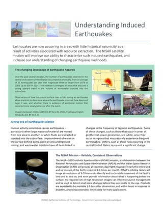
  • 1. ã2017 California Institute of Technology. Government sponsorship acknowledged. A new era of earthquake science Human activity sometimes causes earthquakes – particularly when large masses of material are moved from one area to another, or when fluids are extracted or injected into the subsurface. Impoundment of water on the surface behind dams, open pit and underground mining, and wastewater injection have all been linked to changes in the frequency of regional earthquakes. Some of these changes, such as those that occur in areas of geothermal power generation, are subtle, since they occur in regions that may naturally experience frequent earthquakes. Others, such as those now occurring in the central United States, represent a significant change. Understanding Induced Earthquakes Earthquakes are now occurring in areas with little historical seismicity as a result of activities associated with resource extraction. The NISAR satellite mission will improve our ability to characterize such induced earthquakes, and increase our understanding of changing earthquake likelihoods. The NISAR Mission – Reliable, Consistent Observations The NASA–ISRO Synthetic Aperture Radar (NISAR) mission, a collaboration between the National Aeronautics and Space Administration (NASA) and the Indian Space Research Organization (ISRO), will provide all-weather, day/night imaging of nearly the entire land and ice masses of the Earth repeated 4-6 times per month. NISAR’s orbiting radars will image at resolutions of 5-10 meters to identify and track subtle movement of the Earth’s land and its sea ice, and even provide information about what is happening below the surface. Its repeated set of high resolution images can inform resource management and be used to detect small-scale changes before they are visible to the eye. Products are expected to be available 1-2 days after observation, and within hours in response to disasters, providing actionable, timely data for many applications. The changing landscape of earthquake hazards Over the past several decades, the number of earthquakes observed in the central and eastern United States has jumped dramatically, from an average of 21 earthquakes per year with magnitude three or larger from 1973 to 2008, up to 659 in 2014. The increase is strongest in areas that also saw a strong upward trend in the volume of wastewater injected into the subsurface. Observations of how the ground surface rises or falls during an earthquake allow scientists to determine where the earthquake occurred, how deep and large it was, and whether there is evidence of additional motion that occurred more slowly before or after the event. Image (clockwise): USGS, USBR (CC BY-SA 2.0), USGS, Ficelloguy/English Wikipedia (CC BY-SA 3.0)
  • 2. ã2017 California Institute of Technology. Government sponsorship acknowledged. Continued from front page The past decade has seen a substantial increase in the number of earthquakes triggered by human activity, particularly the injection and production of subsurface fluids associated with hydrocarbon production. Oklahoma now experiences more earthquakes each year than California. Efforts to reduce our society’s reliance on fossil fuels also compound the problem, with increases in earthquake frequency associated with energy production at geothermal power plants and at large dams that contribute hydrothermal power to the electricity grid. The increased frequency of earthquakes in regions such as the central United States create new challenges, particularly since the energy and resource needs of our population are likely to continue to grow. Even forecasting the expected damage from these new types of earthquakes is not just “business as usual.” Analyses of shaking reports from the central United States suggest that the distribution of damage from these earthquakes, which tend to be shallower and could have more involvement from fluids within the rock, are different from the damage expected from “traditional” earthquakes, which often occur deep underground. Precise estimates of the location and timing of these earthquakes are needed to characterize how they interact with each other and with the perturbations to the subsurface that are driving them. The upcoming NISAR radar mission includes a dependable, regular observation plan that will collect high resolution images over 90% of the Earth’s land surfaces at weekly intervals. NISAR’s focus on regular and repeated observations contrasts with that of existing satellite synthetic aperture radars, which typically focus only on areas of interest to a specific government or scientific agency. This leaves out much of the United States, because none of the other radars are U.S. missions. For instance, the central and eastern United States was not observed frequently, if at all, by most previous missions. The observations made over the lifetime of NISAR will be a giant step forward in our understanding of induced seismicity, and will inform the next generation of methods for characterizing and managing these hazards. Number of earthquake sequences each year that contain at least one magnitude 3 or larger earthquake, since 1973, for California (light blue) and Oklahoma (dark blue). From McGarr et al., 2015, in the journal Science. Recent advances in the technology used in hydrocarbon production, including enhanced oil recovery and increases in the volume of wastewater injected into the subsurface, are associated with a dramatic increase in earthquakes felt in the central United States since the mid-2000’s. Damaging earthquakes only appear to be related to a small fraction of wells, but there is not yet enough data to definitively determine in advance the safety of operations at a particular site. Earthquake locations derived from seismic data (see figure at left) illuminate part of the picture – new research shows that induced earthquakes may behave in slightly different ways than “natural” events, providing a potential pathway to better understanding and management. However, seismic data is blind to the slow, longer term deformation of the ground surface associated with pumping, injection and even incipient creep on faults that will eventually rupture in a more damaging earthquake. NISAR can provide the missing link to this puzzle, complementing the available seismic data and helping to track how patterns of fluid flow beneath the surface relate to patterns of observed earthquakes. Increasing rates of earthquakes in the central United States. - California - Oklahoma
  • 3. ã2017 California Institute of Technology. Government sponsorship acknowledged. Induced earthquakes imaged from space: Satellite-based radar imagery, when available, can be an extraordinary tool for characterizing how the Earth’s surface warps and deforms before, during, and after induced earthquakes. However, these observations cannot be made when the ground surface changes significantly between image acquisitions. Growth of crops, tilling of fields, trees shedding their leaves are all processes that degrade data quality. The examples of induced earthquakes in the central United States shown below are cases where we were fortunate to have data both before and after the earthquake. Many other earthquakes in these regions have been impossible to study because of the complete lack of data before the event. This situation can change in the future: NISAR data would be acquired regularly over the entire United States, allowing imaging of areas like Oklahoma, Texas and Kansas that have both active agriculture and hydrocarbon/water resource development. Right: Even tiny earthquakes can be imaged when enough data is available. This image uses data from the European Space Agency’s TerraSAR-X platform to constrain subsidence of the ground during a 2013 magnitude 3.2 earthquake within the Chicago metropolitan area, triggered by a blast at a limestone quarry. Color indicates displacement of the ground surface towards or away from the satellite, which was traveling to the northwest in the direction of the blue arrow and aimed down towards the Earth in the direction of the red arrow. The observed displacement shown here tightly constrains the depth of this earthquake to 700 meters, much shallower than the zone where “natural” earthquakes occur. Examples: Left: NISAR data will permit systematic mapping and monitoring of earthquakes, even in agriculturally active areas. In this example, using data from the European Space Agency’s Sentinel- 1a and -1b platforms, we can see several centimeters of displacement over a 10 km x 10 km region associated with the 2016 magnitude 5.8 Pawnee, Oklahoma, earthquake. The main earthquake location (red star) and aftershocks (black dots) outline a complicated pattern that provides insight into the patterns of weakness in the subsurface. Also in this image (red band on left) is the signature of a large storm that was present during one of the image acquisitions. When many images are available, such as would be provided by NISAR, such atmospheric effects can be averaged out more effectively to determine the true ground movement.
  • 4. ã2017 California Institute of Technology. Government sponsorship acknowledged. For more information: General introduction: https://earthquake.usgs.gov/research/induced/ http://nisar.jpl.nasa.gov/ Community reports Petersen, M.D. et al. (2016), 2016 One-year seismic hazard forecast for the Central and Eastern United States from induced and natural earthquakes, U.S. Geological Survey Open-File Report 2016-1035, 52 p., doi:10.3133/ofr20161035. McGarr, A. et al. (2015), Coping with earthquakes induced by fluid injection, Science, 347; doi: 10.1126/science.aaa0494. National Research Council (2013), Committee on Induced Seismicity Potential in Energy Technologies. Induced seismicity potential in energy technologies. National Academies Press, 2013. National Earthquake Resilience: Research, Implementation, and Outreach (2011), National Academies Press, Washington, D.C. Relevant scientific papers. Jha, B., et al. (2015), Reservoir characterization in an underground gas storage field using joint inversion of flow and geodetic data, Int. J. Numer. Anal. Meth. Geomech, 39, 1619 – 1638. Yang, Qi., et al. (2015), InSAR monitoring of ground deformation due to CO2 injection at an enhanced oil recovery site, West Texas, International Journal of Greenhouse Gas Control 41; doi: 10.1016/j.ijggc.2015.06.016. Hough, S. E. (2015), Shaking intensity from injection-induced versus tectonic earthquakes in the central- eastern United States, The Leading Edge 34; doi: 10.1190/tle34060690.1. Keranen, K. M. et al. (2014), Sharp increase in central Oklahoma seismicity since 2008 induced by massive wastewater injection, Science, 345; doi: 10.1126/science.1255802. Barnhart, W. et al. (2014), Seismological and geodetic constraints on the 2011 Mw5.3 Trinidad, Colorado earthquake and induced deformation in the Raton Basin, J. Geophys. Res., 119; doi:10.1002/2014JB011227. Ellsworth, W.L. (2013), Injection-induced earthquakes, Science, 341; doi:10.1126/science.1225942. González, P. J. et al. (2012), The 2011 Lorca earthquake slip distribution controlled by groundwater crustal unloading, Nature Geoscience, 5; doi:10.1038/ngeo1610. Ketelaar, V. B. H. (2009), Subsidence due to hydrocarbon production in the Netherlands, In: Satellite Radar Interferometry: Subsidence Monitoring Techniques, Springer, London, doi:10.1007/978-1- 4020-9428-6_2 National Aeronautics and Space Administration For more information, visit http://nisar.jpl.nasa.gov/applications Jet Propulsion Laboratory / California Institute of Technology / Pasadena, California / www.jpl.nasa.gov