SlideShare une entreprise Scribd logo
1  sur  85
Télécharger pour lire hors ligne
TEACHING AMERICAN HISTORY
                     CURRICULUM MATRIX
NAME: Edna Kovacs, Ph.D.                    SCHOOL:      Fernwood Middle School and
      Elizabeth Thiel                                    Gregory Heights Middle School

UNIT TITLE:
Nihonmachi: Japan Town Remembered

TARGET GRADE LEVEL: 8th Grade Language Arts and Social Studies

APPROXIMATE TIME NEEDED: About 3 weeks, 2 periods a day

PREREQUISITES: General knowledge of U.S. history, from the 1500’s through the 19th
century

OVERVIEW (Abstract):

Portland’s “Old Town” was a diverse community of immigrants around the turn of the 20th
century. In three weeks (2 periods a day), students will explore urban immigration to Portland’s
Old Town, as well as their own immigrant/migrant experience to Portland, in relation to larger
historical themes of immigration and migration.

Students will produce a packet that encompasses multi genre written responses to literature,
primary source documents, and GIS materials.

Students will gain awareness of urban renewal, how and why Portland’s immigrant population
changed over time, through an interactive, experiential scavenger hunt through Portland’s “Old
Town” as well as investigative research into GIS census data.

Students will meet Portland Public Schools standards in reading, writing, geography, history, and
social studies. Students will be assessed according to the standardized procedure which
examines academic success as well as effort.

                                         STANDARDS

NATIONAL HISTORY STANDARDS:

       Era 6: The Development of the Industrial United States (1870-1900)
          Standard 2:
          Massive immigration after 1870 and how new social patterns, conflicts, and ideas of
          national unity developed amid growing cultural diversity

       Era 7: The Emergence of Modern America (1890-1930)
          Standard 1:
How Progressives and others addressed problems of industrial capitalism,
           urbanization, and political corruption
           Standard 2:
           The changing role of the United States in world affairs through World War I

PORTLAND SOCIAL STUDIES STANDARDS

       History
       3. Students will know and understand the factors, experiences and impacts of historical
       and contemporary movements and settlements of people.
       6. Students will know and understand the concept of culture and its relationships to
       region and place, and influences on cooperation and conflict.

       Citizenship
       1. Students will examine and debate the concept of citizenship, specifically the roles,
       rights (individual and group) and responsibilities of the citizens of the United States.

       Fulfill Civic Responsibility
       8. Students will participate in formal and informal activities to promote the well being of
       society

       Maps and Other Geographic Representations
       1. Students will demonstrate their ability to use maps and other geographic
       representations to locate, organize and interpret information about people,
       places and environments.

       Global Economics
       3. Students will understand, analyze and study the dynamics and impact of global
       economic relationships.


                                            LESSONS

Lesson 1: Personal Immigration Stories
Lesson 2: Understanding Key Terms
Lesson 3: A Brief History of Portland to 1900
Lesson 4: Old Town Field Trip and Scavenger Hunt
Lesson 5: Old Town Through the Eyes of Rose and Cherry
Lesson 6: Primary Sources – Photographs
Lesson 7: Primary Sources – U.S. Census
Lesson 8: Primary Sources – Quotations about Japanese Experience
Lesson 9: Crime in Old Town 1917
Lesson 10: Japanese Internment in Portland
Lesson 11: Internment – Only What They Could Carry Activity
Lesson 12: Portland – Then and Now
Lesson 13: Tales of Old Town
LESSON PLANS:

Lesson 1: Personal Immigration Stories
Objective: To introduce students to the idea of immigration through their own families’ history;
to begin thinking about immigration as a factor in the development of our country and our
culture.

Materials: World map, finger paint, ArcView GIS software

Procedure:

Introduction: Ask students how they got to Oregon. Take several responses. For students who
were born here, ask how their parents got here. For students whose parents were born here, ask
how their grandparents got here. Extend the discussion to how students’ relatives first arrived in
the United States. Tell students that when someone moves from one country to another, this is
called immigration. Tell them that we will be discussing immigration for the next few weeks.

Pair: Have students get with a partner. Have each student tell the other how his/her family came
to the United States. Think of every country that your relatives immigrated from. Tell students
to be ready to share this information with the class, and to find each country on a map or atlas.

Share: Have each student come up and share with the class their family’s roots. Encourage
students to tell a little about each relative, and why they came to the U.S. Each student can put a
dot on the map with finger paint on the countries that their relatives immigrated from.

Synthesis: Ask students to look at the completed map with all its dots, and look for any patterns.
What other information would be interesting to know about these immigration stories?

Extension: For students who are already ArcView savvy, have them code the class map into
ArcView (see instructions).

Modification: For students who aren’t sure where their relatives came from, give them an extra
evening to go home and find out.
ArcView 3.3 GIS Instructions:
   How to START ArcView Personal Immigration
                  Story Project


                            Click on the “Start” menu at the
                            bottom left corner. Click on
                            “Programs” then click on
                            “ESRI.” Click on the
                            “ArcView GIS 3.3” folder.
                            Finally, click on the “ArcView
                            GIS 3.3” program.


A box that says
“Welcome to ArcView
GIS” should appear
once the program
launches. Click on the
button for “Open an
existing project.” Then
click on OK.
Navigate to the C: drive (double-click on the c: in the middle box). Navigate to
the folder where a project called “personal immigration stories.apr” is located (ask
your teacher). Double-click on the APR file (you should see it in the left box).


What you should see
is an outline map of
the world and the
United States. You
can use this map view
to place dots on the
countries or states
where your ancestors
immigrated from.
ArcView 3.3 GIS Instructions:
    How to IDENTIFY Countries and U.S. States


                                            This is the MAP.

 This is the
 LEGEND.


Notice that there are two layers (also called THEMES) in the LEGEND (Countries of the World
and United States). Both have checkmarks in the box to the left. This means that the layer is ON
(it is drawing in the MAP area). If you click on the checkmark it will turn off and not draw in
the map area.

One theme looks a little different – it seems raised or popped out (Countries of the World). This
means it is ACTIVE. If you want to find out the name of a country then the COUNTRIES OF
THE WORLD layer must be ACTIVE. If you want to find out the name of a state then the
UNITED STATES layer must be ACTIVE. All you need to do to make a theme ACTIVE is to
click on the name of the theme.
USING THE ID TOOL:


                        This is the ID TOOL. Click on the ID Icon then click on a country
                        (or State if the United States theme is active). Another window will
                        pop up showing you all the available information about that country
                        including its name.


 Hint: Use the ID TOOL to locate a country or state if you are not sure where it is on the map.
 Or, you can also use an Atlas.
ArcView 3.3 GIS Instructions:
                    How to Place a Dot on the Map
                                                            Step 1: Choose your dot’s
                                                            Style, Color and Size.


                                                             Click on the word “Window” on
                                                             the menu bar. Then click on “Show
                                                             Symbol Window” in the middle.
                                                             This will open another window
                                                             where you can choose your dot
                                                             style, color and size.


                                    Click on this icon to open up the POINT marker selections.


                                    In this area you can select the STYLE of your point. Scroll down
                                    using the bar on the right to see more choices.


                                    Use this drop-down box to select the SIZE of your point. A value of
                                    10 is good for this exercise.


                               Click on this icon to get into the
                               color area. Here is where you
                               can choose the COLOR of your
                               point. Scroll down (the bar on
                               the right) to see more color
                               choices.


Hint: You can close this Palette Window by clicking on the “X” in
the far upper right corner.
STEP 2: Place your
                                 Point on the Map


                                                These are the GRAPHICS Tools. Click and hold to get
                                                the drop down list. Click on the POINT. This makes
                                                your POINT the ACTIVE tool.


   Click on the map where you want your
   point to be placed. Notice the 4 black
   squares around your point (these are
   called handles). This means that this
   point is SELECTED. When a point is
   selected you can move it around using
   the mouse or delete it (using the
   DELETE key on the keyboard). If you
   want to move or delete a point that is
   not currently selected (it doesn’t have
   handles around it), click on the
   POINTER TOOL, then click on the
   point to select it.


Hint: When a point is SELECTED you can also change its size and color. Look back in these
instructions to see how to access the SYMBOL WINDOW. You may want to make increasingly
bigger points to show where your ancestors journeyed on their way to Oregon. Or, you may want to
have different color points to show countries or states where you have relatives.
ArcView 3.3 GIS Instructions:
             How to LABEL your POINTS


                                   These are the TEXT TOOLS. Click and hold on
                                   the big “T” to get the dropdown list. Then click
                                   on the third option. This one will allow you to
                                   type a LABEL with a line attached to your point.


STEP 1: Start at the point you                       STEP 2: Let go of the mouse
want to label. CLICK, HOLD and                       and a TEXT BOX will appear.
DRAG your mouse to draw a line                       Type in the LABEL (you can
from the point to an empty space                     use the ENTER key to add
on the map.                                          lines). Then click on OK.
Hint: You can select other kinds of label tools as well. Use the BANNER label to create a title
for your map. Use the regular “T” or TEXT tool to type your name and the date on your map.

Also, you can SELECT and delete labels if you want to change them. Use the POINTER TOOL
to SELECT the label (when selected it will have the handles). Then you can use the DELETE key
to erase the label.
ArcView 3.3 GIS Instructions:
How to SAVE and PRINT your Map


               SAVING YOUR MAP:

               Click on FILE on the menu bar. Click on
               SAVE PROJECT AS.


               In the next box (SAVE PROJECT AS) you
               will need to “navigate” to a place on the
               computer you can save files (ask your teacher).
               Then, in the FILE NAME area you should type
               your name or a name for your map.
PRINTING YOUR MAP:

                                Click on FILE on the menu bar. Click on PRINT.


                                The PRINT box will appear. You will need to click on
                                the SETUP button and choose an accessible printer (ask
                                your teacher). Click on OK when finished.


          Choose an
          available printer
          here.


Make sure that this is set to
LANDSCAPE so your map
prints out correctly.
Lesson 2: Understanding Key Terms
Objective: To introduce students to the terms that they will be using to think about immigration
in Portland.

Materials: Concept maps, Concept Map overhead, Creating America

Procedure:

Introduction: On the chalkboard, write the following terms:

•      Immigration
•      Urbanization
•      Migration Patterns
•      Support Society
•      Urban Renewal
•      Industrialization

Tell students that they will be using these terms to learn about immigration in Portland, so it is
important that everyone have a good understanding of what these terms mean.

Concept mapping: Hand out enough concept maps for each student to have one for each term.
Use the Concept Map overhead to guide students as they make a concept map of the first word.
Ask students to help fill in the map. Map each word together as a class, having students come up
to share their work on the overhead.

Historical Background: Ask students to read Creating America Chapter 21.1, which discusses
immigration in the late 19th century. Have students answer the Section Review Questions.
Discuss these questions as a class.

Synthesis: To close, discuss with students the similarities and differences between what they
read and thought about today, and the stories about their families that they shared yesterday.
Lesson 3: A Brief History of Portland to 1900
Objective: To give students the background needed to understand how profoundly immigration
affected Portland around the turn of the century. To share with students the history of their city.

Materials: Powerpoint Presentation—derived from “Portland Project” CD; Creating America

Procedure:

Introduction: Tell students that to understand the impact that immigration had on Portland, they
need to know a little about Portland before the great immigration waves of the turn of the
century,

Presentation: Power Point using historic images of Portland. Discuss with students the history
of Portland, from its inception in the 1830’s until the 1900’s. Point out existing landmarks,
buildings, streets.

Silent Reading: Read Creating America 21.2 (industrialization). Have students answer section
review questions.

Synthesis: Have students compare what they read in their text book with what they learned and
know about Portland. How does Portland compare with other industrializing cities?


Lesson 4: Old Town Field Trip
Objective: To give students a first-hand knowledge of Portland history, and to see how
Portland’s history is still alive today.

Materials: Scavenger Hunt Packets, Field Trip Itinerary

Procedure:
Take bus/MAX downtown
Walking Tour or historical Old Town/ Urban Renewal (see scavenger hunt packets)
Visit Jewish Museum—presentation by director
Lunch
Visit Nikkei Legacy Center/ Japanese Memorial—presentation by staff
Tour of Old Japan Town (Echoes, echoes, echoes!)
Return to School
Old Town Chinatown
                                PPS Student Field Trip Itinerary

Background
Portland Public Schools teachers Edna Kovacs and Elizabeth Thiel, as a component of their
Teaching American History curriculum units, are developing a field trip template for middle
school teachers in the Portland area. The field trip encompasses what is known as Chinatown,
Old Town, and a portion of the Pearl District. The emphasis of the day’s activities is to provide
the students with understanding and appreciation of the region’s rich cultural and architectural
heritage. With time constraints, it will only be possible to visit and tour select sites within the
region, but the sites selected broadly represent the multicultural and multiuse nature of the area.
As a tactic to maintain student engagement throughout the day, as well as serving as a learning
tool and producing student work, the students will be given a “guide” for the day’s activities.
This guide will provide a brief history of the region, information about significant sites, field trip
tour route, and a historical “scavenger hunt” component. The students will be required to turn
in their completed handout to PPS teachers following the field trip.

Dates: May 17 (Monday), May 19 (Wednesday), May 20 (Thursday)

Itinerary (same daily)
10:10 – 10:30 Zimmerman Community Center
Students will learn about the tremendous revitalization of the area, and preview the day’s
activities. Starbucks refreshments.

10:30 – 11:30 Walking Tour, Part One
Urban Change, Renewal in the Pearl and Old Town

11:30 – Noon Oregon Jewish Museum
Judy Margles or representative will discuss the Jewish presence in the neighborhood and
Portland in general.

12:15 – 1:10 Old Town Pizza Company
The Old Town Pizza Company is housed in a former brothel and gambling parlor.

1:15 – 1:35 Oregon Nikkei Legacy Center
Presentation by an ONLC representative relating to the Japanese community in Old Town and
the subsequent internment. Students will view exhibit as well.

1:45 – 2:00 Japanese Internment Memorial at Waterfront Park
An ONLC representative will lead the students from ONLC to the memorial and discuss the
significance and meaning of the memorial.

2:10 – 2:45 Japantown Walking Tour, Part Two
Guided walk through significant sites to the Japanese community.

3:00 Walking Tour, completion (segment two)
Enroute to the MAX station, students will complete the Old Town Walking Tour.
PORTLAND STUDENT WALKING TOUR
                     Historical Scavenger Hunt Activity Worksheet

STARTING POINT:
Zimmerman Community Center or Park Blocks

Part One, Segment One:
   1. NW 10th Avenue & Glisan (looking north)
        • How has the area around this intersection changed since c.1920 photograph?


           •   Do any of the same buildings remain?


           •   What is this process of city development called?


   2. NW Glisan & Park. Note the cobble streets and trolley tracks, now covered over by asphalt.
      This layer of street can still be seen in certain parts of town where asphalt is coming loose.

   3. Broadway & Everett Golden West Hotel
         • What is the significance of this hotel to early Portland history?


           •   Who ran the barber shop?


           •   Who was the hotel proprietor?


   4. Broadway & Everett (looking south)
         • What building is this?


           •   Why did the river flood downtown as shown in the photograph?


   5. NW Couch & 6th Avenue. Former brothel (top story) and grocery (bottom story) ran by an
      “oriental couple” who ran both from 1920-1940.

   6. Burnside at 5th Avenue (looking west)
         • How is it different today?


           •   Do you recognize any of the same buildings? If so, which ones?


   7. 69 N. 4th Avenue. Bow Yen Grocery & Dry Goods was also a gambling hall. It was turned
      into a city parking lot in order to provide tourist parking and clean up of “blighted” buildings.
          • This type of city development would be called what?
PORTLAND STUDENT WALKING TOUR
                      Historical Scavenger Hunt Activity Worksheet

   8. 4th Avenue & Davis. Hop Sing Tong Headquarters. Fong Chong now at the site.
          • Why were tong associations important within the Chinese-American community?


   9. 310 NW Flanders. Hotel American in back and Royal Palms Hotel in front. Provided
      rooming houses for the railroad and logging workers.
          • What is the Hotel American site presently?


   10. Union Station (train station)
          • What is the architectural style of the station?


           •   When was the station constructed?


Part One, Segment Two:
   11. Erickson’s Saloon, 5 NW 2nd Avenue. Important social spot for Portland laboring class and
       immigrants.
           •       Why did Erickson’s give “free meals” to its patrons?


           •       How was it that the bar became world famous?


   12. Ballis Dock Building, 1st & Burnside. Moved during the widening of Burnside Street.
           • What is the building now used as?


   13. New Market Theater, 50 SW 2nd Avenue. C.1873. “There was no ‘amusement palace’ so
       elegant north of San Francisco” at the time.
           • Why was cast iron prefab facades used for early Portland buildings?


           •   In 1869 the Ankeny Block held a record for what?
PORTLAND STUDENT WALKING TOUR
                Historical Scavenger Hunt Activity Worksheet


Part Two: Japantown

  A. Mikado Bath, 306 NW Everett. The entrance to the community bath, now closed, leads
     to the basement of what used to be the Mikado Hotel. The bathhouse has a large
     communal bath for men and a separate smaller one for women. Men’s bath was 7x15
     feel across, like a small pool.
  B. Mary’s Café, NW 3rd & Davis. Ran by two Issei men serving western-style food,
     pancakes, steaks and potatoes.
  C. Foster Hotel, 216 NW 3rd Avenue. It was significant to Japantown in that many of the
     tenants were Japanese workers.
  D. Mr. Daiichi Takeoka’s Law Office, 208 NW 3rd Avenue. Mr. Takeoka graduated from
     the University of Oregon law school, but could not practice law legally as an Issei. He
     was used by the community for legal consult. He also led the community in an effort to
     repeal the Oregon Alien Land Laws of 1924 and 1946, laws which prohibited Issei from
     owning land and working on farms.
  E. Judo Obukan, 219 NW Davis. This served as a citywide Obukan Judo club. This club
     often held tournaments with clubs from Salem, Seattle, Hood River, etc.
  F. Oshu Nippo, 131 NW 2nd Avenue. This was the Japanese Daily Newspaper. It has 8-10
     employees who ran the paper on an old printing press. This newspaper was the only
     communication link for Japanese Issei and the outside world at the time.
  G. Merchants Hotel, 123 NW 2nd Avenue. The Merchants Hotel covered an entire ½ block.
     It was the heart of Japantown.
  H. Matsubu Laundry, 121 NW 2nd Avenue. The laundry served two purposes – clean soiled
     laundry and provide bath services for workers. Typically workers would take a weekly
     bath and get their clothes laundered at the same time, in preparation for weekly leisure
     time with their friends.
  I. Oregon Nikkei Legacy Center, 117 NW 2nd Avenue. Center for Japanese Cultural and
     Heritage in Portland. Exhibits, educational programs, and collections for community
     posterity.
OREGON JEWISH MUSEUM
                       Scavenger Hunt Worksheet


1. What year was the first Jewish wedding between two native Oregonians?


2. What Oregon woman fought to win the right to vote?


3. Which Rabbi got caught with golf clothes under his robes?


4. What happened to the second Congregation Beth Israel building?


5. Who worked extensively with Braille in the Beth Israel Sisterhood and met Pat Nixon
   and Julie Eisenhower?
OREGON NIKKEI LEGACY CENTER
                          Scavenger Hunt Worksheet


1. Find the name of a Japanese business in Nihonmachi before the War.


2. Find the Notice that required Japanese Americans to go to the Portland Assembly Center.
   What date were they required to be at the Assembly Center?


3. What is contraband? Find the display case where contraband is located and find one
   contraband item.


4. List the names of two people that helped Japanese Americans during relocation to the
   Assembly Center.


5. List items people were allowed to bring to the Assembly Center.


6. Name three jobs that people had at the Assembly Center.


7. Name recreational activities at the Assembly Center.


8. Identify the name of the Japanese American newspaper at the Assembly Center.


9. Where did some people go after the Assembly Center?
Lesson 5: Old Town through the Eyes of Rose and Cherry

Objective: For students to relate their experiences on yesterday’s field trip to literature, history,
and geography through mapmaking.

Materials: “Flower Girls” Reading (see resources for citation); Old Japan Town through the
Eyes of Rose and Cherry Handout

Procedure:

Introduction: Tell students that today we will be reading a story that takes place on the very
streets where they walked yesterday.

Read Aloud: Have the class play “readers tag” as you read “Flower Girls” by Lawson Inada.
Ask students to take out a highlighter and highlight the names of places as they are read in class.

Mapping: See “Old Town through the Eyes of Rose and Cherry” handout. Have student follow
the directions on the handout. Use an overhead map of Nihonmachi to assist students in locating
the streets and avenues.

Synthesis: When students have had time to work on their maps, ask volunteers to point out
features on the map that they saw yesterday. Discuss the “reality” of the story, and how we
know what we do know about how Old Japan town used to look.
Name ________________________________________________________________________

                 Japan Town through the Eyes of Rose and Cherry
Directions:

Label the following streets on the map of Japan Town:

       NW Couch St.                 NW 1st Ave.
       NW Davis St.                 NW 2nd Ave.
       NW Everett St.               NW 3rd Ave.
       NW Flanders St.              NW 4th Ave.
       NW Glisan St.                NW 5th Ave.
       NW Irving St.                NW 6th Ave.
       Burnside St.                 NW 9th Ave.
                                    NW 10th Ave.
                                    NW 11th Ave.

Shade in the area that was considered Japan Town (between 2nd and 6th Avenues, and between
Burnside and Glisan Streets).

Draw a symbol for each of the following places. Put this symbol on the map in the correct place
and on your map key.

       Union Station – Irving Street between 6th and Broadway
       Atkinson School – 11th and Davis
       Mikado Baths – 306 NW Everett St.
       Oshu Nippo Newspaper Office – 131 NW 2nd Ave.
       Blitz Weinhard Brewery – 10th and Flanders
       Japanese Dance Studio – 322 NW 3rd Ave.

Pick 5 more places that Rose and Cherry visited in Old Japan Town and place them on the map
where they might have been. Draw a symbol for those places on the map and on the map key.

Draw the kappa, as you imagine him in or near the Willamette River.

Draw the route of Rose and Cherry doing “the regular things.”

Color your map and make sure everything is labeled and listed in the map key.
Lesson 6: Primary Sources - Photographs

Objective: Students will glean historical information and make inferences from photographs; to
begin the brainstorming process for fiction writing.

Materials: Photographs from Old Japan town—at least 1 per student (OHS or Nikkei Center are
good sources for photographs).

Procedure:

Introduction: Ask students to think of ways that we can know about what Old Town Portland
was like in the past. Discuss several ways (first hand accounts, photographs, history books).

Tell students that this week, they will begin working on a short story that takes place in Old
Town Portland, and they will be using various primary sources to inform their stories. Review
what a primary source is. Tell students that today, we are going to be looking at one kind of
primary source -Photographs.

 Model: On the overhead, put a high interest historical photograph of Old Town Portland. Ask
students what they see. Discuss how we can learn about the past through photographs. Ask
students to list things they can know about the past from this photograph. Have a student list
these things on the board. Then have students think of things they can infer from this image.
Discuss the difference between knowing and inferring. Tell students that they will be doing the
same thing on their own.

Individual Work: On students’ tables, lay out photocopies of photographs of Old Town Portland,
enough for each student to have one. Direct students to each pick one photograph. Students
should study their photograph, and use it to try to understand an aspect of life in Old Town
Portland. On a separate sheet of paper, each student should list 5 things they can know from the
photo, and 5 things that they can infer from the photograph. When they have done this, they
should write a 1-2 page character sketch of a person in their photo. They should include physical
characteristics, relationships, activities, personality, etc. Remind students that of course, they
can’t get all this information from the photo; they will have to use their imaginations.

Synthesis: For the last 10 minutes of class, have students share the character sketches they are
working on. Have them finish these at home, if necessary. Tell students that they will be using
these character sketches in a short story that they will be writing.
Lesson 7: Primary Sources – U.S. Census

Objective: To introduce students to GIS, and how we can use it to learn about history, and in
particular, about Old Town Portland.

Materials: 1930 Old Town Census ArcView Project; Infocus projector; GIS teacher instructions
and student instructions/worksheet

Procedure:

Introduction: Remind students of yesterday’s discussion of “primary sources.” Yesterday, we
looked at photographs. Tell students that today, they will begin looking at another primary
source—the 1930 U.S. census data for Old Town. Explain what a census is, how often they are
taken, and why they are taken. Explain that this data has only recently been formatted to look at
using a special software called GIS.

Presentation: Using a projector, show student the 1930 census data for Old Town, prepared in an
ArcView GIS project. Demonstrate how to use the software to learn about the people of Old
Town. Tell students that they will have a chance to explore this data themselves.

Writing Assignment: Tell students that they will be using the information from the 1930 census,
as well as their photographs from yesterday, and other primary source information, to write a
fictional story that takes place in Old Town. Hand out Old Town Story rubric, go over it with
the class, and assign due dates for the 1st, 2nd, and 3rd drafts. Tell students to use their character
sketches (Lesson 6) as a basis for their story, and use the census information to give specific
information about people and places that their character may have encountered.

Individual Work: Have students get in pairs/triads to complete the “GIS” worksheet. If there are
not enough computers for everyone to work, tell students that they will all have a chance
throughout the week. Students who are not able to get on a computer today should continue
working on their short story.
OLD TOWN AND JAPANTOWN:
               EXPLORING THE 1930 CENSUS DATA USING GIS

TEACHER GUIDE FOR U.S. CENSUS ARCVIEW DEMONSTRATION

To Launch ArcView and Open the US Census Project:

1. Click on the “Start” menu at the bottom left corner. Click on “Programs” then click on
“ESRI.” Click on the “ArcView GIS 3.3” folder. Finally, click on the “ArcView GIS 3.3”
program.

2. A box that says “Welcome to ArcView GIS” should appear once the program launches. Click
on the button for “Open an existing project.” Navigate to the C: drive (double-click on the c: in
the middle box). Navigate to the folder where the project called “oldtown1930census.apr” is
located. Double-click on the APR file (you should see it in the left box).

What you should see are sections of old fire insurance maps (Sanborn maps) hand-drawn in
1932. You should also see blue dots which represent people living in this area according to the
1930 U.S. Census. The area that shows on the screen is Old Town in downtown Portland.

Learning about GIS and Spatial Data: The Map View

1. Explain that GIS means Geographic Information Systems. It is a way to use a computer to
visualize information about the places that we live (our geography). Looking at these kinds of
“maps” should be familiar – remind students of the World Map exercise, the field trip and their
Japantown map activities.

2. Explain that the “layers” on the left (in the Legend) are called THEMES in GIS. Themes
represent different kinds of geographic data. Different themes could be streets, rivers, parks,
schools, etc. Ask students if they can think of other kinds of “themes” that they might have seen
on a map (i.e. physical features such as soil types, etc.).

3. Turn the themes ON/OFF (using the checkmark to the left of the theme) to show how the
computer draws the themes and also explain ACTIVE/INACTIVE (clicking on the theme name
makes the theme “pop out” a bit – this means that it is ACTIVE). A theme needs to be ACTIVE
in order for the computer to know which theme that you want to find out information or ask a
question about.

The Data Behind the Map:

1. Explain to students that there is lots of information “behind” the picture that they see in the
Map View. Open the Theme Table             for the 1930 Oldtown Census Data (make sure that this
layer is ACTIVE).
2. Scroll across the table to show students the kind of information that the Census collected in
1930 (these are the Columns). Refer to 1930 Census Metadata Sheet (found in the Nihonmachi
folder) for what the column headings mean (e.g. Hv_cmr = Value of Home or Monthly Rent).

You can find an unusual piece of information (e.g. Radio) and ask students why they might think
that the U.S. Census would be interested in such information. What would they do with that
information? Do the students think that this same information is still collected today? Tidbit:
The government is interested in finding out how many people have access to technology. In 1930
it was the radio. More recently, census questions ask about telephones, televisions and
computers.

3. Scroll down the table to show students how many RECORDS (or rows) there are in the table.
Each record translates to a point on the map and represents each person living in Old Town in
1930. You can find the total number of records in the upper right corner (there are 2188 records
in this dataset).

Asking Questions using GIS: Zooming in to an Area of Interest

1. Use the MANUAL ZOOM IN Tool                 to take a closer look at the block from Davis &
Couch and 2nd Avenue (see graphic below). This is the heart of Japantown that the students
visited on their fieldtrip. Click on the MANUAL ZOOM IN tool to make it active. Starting
from the upper right corner of the block, click-hold-drag the mouse to draw a rectangle around
the area you want to zoom in to. When you let go the computer will zoom in to the area you
defined.

THE OOPS KEY!              If you make a mistake and want to return to where you were before,
click on this tool and it will take you backward one step (you can click on this tool several times
to go backwards even more).


                                                  2nd
                                                  Ave.
2. Ask the students if they recognize any of the sites that they visited on their Japantown
Walking Tour. Hint: The Oshu Nippo Print shop is on the SW corner of Davis & 2nd and the
Merchants Hotel is on the SE corner of Davis & 2nd. The Matsubu Laundry & Bath is on the
NW corner of Couch & 2nd.

Other general information about the Sanborns if students ask (a more detailed Sanborn key is
located in the Nihonmachi folder):
    • Color codes refer to the building type (red=tile or brick; yellow=wood frame;
       blue=concrete)
    • Letter codes (S=storefront; A=outbuilding)
    • Floors – the number of floors can be identified by a number in the corner of the building
       section.

3. Ask students if they notice a pattern in the points. Hint: Most of the points are CLUSTERED
in certain areas on the map. This is where you can explain how to determine the number of
floors in the building (they range from 3-8 floors). The points are clustered because most of the
buildings had storefronts, restaurants and other facilities on the lower levels and lodging/rooms
on the upper floors. The clusters of points are the people that lived in the upper level rooms
(with data this old, it was impossible to locate the points exactly where the people lived in the
building, there were no apartment numbers for reference).

Asking Questions using GIS: Using the ID Tool to Look at Specific Information

1. Click on the ID TOOL           to make it active. With this tool you can look at the actual data
for each of the people (points) shown on the map. Use the cursor to click on one of these dots
(Hint: it will be more effective to choose an isolated point, rather than one located in a large
cluster of points).

2. Use this “Identify Results” window to look at the various pieces of information available for
this individual. You can look at age, marital status, occupation, etc. Refer to the US Census
Metadata for what each piece of information means or have the students look at the metadata as
you identify an attribute from the ID window. (e.g. “It says here that this person’s RACE was
FIL. Look at your Metadata Sheets and tell me what that means.)
Asking Questions using GIS: How to QUERY the US Census Dataset:

We know that this was an immigrant neighborhood (in the heart of Japantown). We want to find
out how many of the people living in these few blocks could speak English. This question will
serve as an illustration of the query process. In the student instructions, the students will use this
same tool to isolate the Japanese residents.

1. Close the “Identify Results” window by clicking on the “X” in the upper right hand corner.

2. Click on the QUERY TOOL            to make it active. The QUERY window will open. You
will use this window to construct your question.

3. In the box marked “FIELDS,” double-click on “ENG.” Then single-click on the “=” sign in
the middle. In the box marked “VALUES,” double-click on “Y” which says English=Yes
(according to the US Census Metadata, this means that this person could speak English).

IMPORTANT: The box at the bottom should now say exactly the following: ([Eng] = “Y”). If
it does not then you will need to close the window (“X”) and start over.

4. Click on NEW SET. All the points (persons) that can speak English (ENG=Y) are now in
yellow (that means they are selected).


5. Open the THEME TABLE              to show how the records in the table have turned yellow
(selected) as well. Scroll around the table to see how many of those persons born in Japan
(BIRTH column) could speak English. Are there lots of English-speaking Japanese?
A Few Navigation Tools:

Conclude the demonstration with a few navigation tools.
1. Close the Theme Table (“X”). Click on the ZOOM TO ACTIVE Tool                (the middle tool
on the navigation bar). This will zoom the map to the spatial extent of the ACTIVE theme (1930
Oldtown Census).

2. Show the students the PAN Tool        . Click the Pan Tool then click-hold-drag the map.

Close the ArcView project by clicking on the “X” in the far upper right corner of the Program’s
window. Do not save (so that the project will open properly next time).
OLD TOWN AND JAPANTOWN:
              EXPLORING THE 1930 CENSUS DATA USING GIS

STUDENT INSTRUCTIONS AND WORKSHEET

To Launch ArcView and Open the US Census Project:

1. Click on the “Start” menu at the bottom left corner. Click on “Programs” then click on
“ESRI.” Click on the “ArcView GIS 3.3” folder. Finally, click on the “ArcView GIS 3.3”
program.

2. A box that says “Welcome to ArcView GIS” should appear once the program launches. Click
on the button for “Open an existing project.” Navigate to the C: drive (double-click on the c: in
the middle box). Navigate to the folder where the project called “oldtown1930census.apr” is
located (ask your teacher). Double-click on the APR file (you should see it in the left box).

What you should see are sections of old fire insurance maps (Sanborn maps) hand-drawn in
1932. You should also see blue dots which represent people living in this area according to the
1930 U.S. Census. The area that shows on the screen is Old Town in downtown Portland.


                                                       Zoom in to this block.
Using ArcView Tools to Explore the U.S. Census Data:

1. Look at the map and zoom in to the block with Couch to the north, Burnside to the south and
in between 2nd and 3rd Streets. You can also choose another block that looks interesting to you.
Here’s how you zoom…Use the ZOOM IN Tool                 to take a closer look at this block. Click
on the tool to make it active. Starting from the upper right corner of the block, click-hold-drag
the mouse to draw a rectangle around the area you want to zoom in to. When you let go the
computer will zoom in to the area you defined. You can see that these maps were drawn in great
detail.

THE OOPS KEY!              If you make a mistake and want to return to where you were before,
click on this tool and it will take you backward one step (you can click on this tool several times
to go backwards even more).


     Here’s the ID
     Tool.


2. Click on the ID TOOL           to make it active. With this tool you can look at the actual data
for each of the people (points) shown on the map. Use the cursor to click on one of these points.
On the “People in Japan Town” worksheet, write down the name and address of the person you
clicked on (this will be Person 1).

The census data tells us a lot about the people who were living in Old Town in the 1930s.
Besides names and addresses, the data tell us about the race, occupation, language spoken as well
as their birthplace, the birthplace of their mother and father and even whether or not they could
read.
3. Use the data table you opened with
                                                      the ID TOOL to find out three more
                                                      facts about the person whose name you
                                                      just wrote down. Use the US Census
                                                      Metadata sheet to figure out what each
                                                      piece of information means. Write
                                                      these facts in Section A on your
                                                      worksheet.

                                                      4. Close the current “Identify Results”
                                                      table (click on the “X” in the upper
                                                      right hand corner).

                                                      5. Repeat Steps 2-3 to learn about 2
                                                      more people living in Japantown in
                                                      1930. Fill in the remaining information
                                                      in Section A on your worksheet.


Asking Questions using GIS: How to QUERY the US Census Dataset:

1. We know that this was an immigrant neighborhood. You may have discovered that people
came from many different countries. We want to find those persons of Japanese ancestry. You
can use the QUERY TOOL to ask this question and locate the Japanese in Old Town.

2. Click on the QUERY TOOL            to make it active. The QUERY window will open. You
will use this window to construct your question.

3. In the box marked “FIELDS,” double-click on “RACE.” Then single-click on the “=” sign in
the middle. In the box marked “VALUES,” double-click on “JP” (according to the US Census
Metadata, this means “Japanese”).

IMPORTANT: The box at the bottom should now say exactly the following: ([Race] = “JP”).
If it does not say this then close the query window (“X”) and start over.

4. Click on NEW SET. All the points (persons) that are Japanese (RACE=JP) are now in yellow
(that means they are selected).
5. Use the ID TOOL to learn about some of these people of Japanese ancestry. Write down the
name, age, and occupation of 3 of these people in Section B on your worksheet.

6. Use the Navigation, ID and Query Tools to answer the questions in Section C and D on your
worksheet. The Quick Reference Guide below will help you to locate the tools.
Name ________________________________________________________________________

                               PEOPLE IN JAPAN TOWN – 1930
Follow the instructions for using ArcView to learn about Japan Town in the 1930s. Fill in the
information below.

A. Using the ID TOOL: People Living In Japan Town


           Person 1                                 Person 2                           Person 3

Name:                                  Name:                                Name:

Address:                               Address:                             Address:

3 Facts:                               3 Facts:                             3 Facts:
1.                                     1.                                   1.

2.                                     2.                                   2.

3.                                     3.                                   3.


B. Using the QUERY BUILDER: People of Japanese Ancestry in Japan Town in 1930.


Name:                                  Name:                                Name:

Age:                                   Age:                                 Age:

Occupation:                            Occupation:                          Occupation:


C. Exploring the Data Tables.

There were people living in Japan Town from all over the world. Find people living in Japan
Town who were born in 5 different countries and list them below:

                 Name                                          Country of Birth
1.

2.

3.
4.

5.


D. Look carefully at the Sanborn Maps. Zoom in to get a closer look, and use the PAN hand to
navigate around the page. Find the names and addresses of at least 5 businesses in Japan Town.

              Business                             Address
1.

2.

3.

4.

5.


E. Go back to your seat and summarize what you have learned from exploring this data. How
could you use some of this information in the story you are writing?

______________________________________________________________________________

______________________________________________________________________________

______________________________________________________________________________

______________________________________________________________________________

______________________________________________________________________________

______________________________________________________________________________

______________________________________________________________________________

______________________________________________________________________________
Lesson 8: Primary Sources - Quotations about Japanese Experience

Objective: For students to glean historical information and make inferences from people’s first
hand experiences with history; To make connections between various sources of information.

Materials: Quotations about Japan Town and Internment, cut into strips of paper.

Procedure:

Introduction: Tell students that today, we will be focusing on another primary source of
historical information—people’s first hand accounts of history. On the overhead, write the
following directions:

        1) Pick a Quote that speaks to you.
        2) Rewrite it neatly and large on a clean sheet of paper.
        3) Illustrate your quote, using images and symbols to capture the meaning.

Tell students that the quote they pick will also work its way into their story.

Individual Work: On each table or cluster, place more that enough quote-strips for each student
to have one. Instruct students to read several quotes prior to choosing one. As students follow
the directions, provide white paper, rulers, and colored pencils.

Writer’s Workshop: Allow students time to continue working on their short stories. Remind
them that the quote they chose today should become a part of their story. Discuss ways to do
this. Students may work on their self-evaluation or their second draft if they are ready.

Synthesis: Have a few students share their illustrations and quote with the class. Have a few
students articulate how the quotes added to what they know about Old Town, and how it will
work into their story.

*** As students work on this assignment, others may be on the computer completing the GIS
assignment.

Extension: Explore writing Japanese forms of poetry – haiku, renga, waka – while listening to
Japanese shakuhachi music.
QUOTATIONS FROM ISSEI AND OTHERS*
The following quotations from Issei, U.S. Government officials and government documents can
be used as resources for examining predictions in the Issei inquiry activity. These statements can
also be used independently as prompts for stories, role plays and individual investigations.

       A. Immigrant and Settlement

Related topics: immigration, alien, discrimination, picture bride, citizenship, Issei, Nisei

“I hope that you summon your wife and make a peaceful home in this great land of freedom.”
(Masuo Yasui)

“According to what people said, in America money was hanging from the trees and one could
rake up treasure like fallen leaves.” (Kunitaro Tanabe)

“I saw that all the people has white skin and hair of different colors! I thought I had landed here
by mistake! And I was troubled when I could not understand them. I truly wondered, ‘For what
purpose did I come here?’” (Hisa Wakamatsu, The Hood River Issei)

“We worked ten hours a day and made $1.15, out of which 10 cents was withheld as
employment commission. White workers got $1.45 per day…The section life at that time was
very crude. Between six and ten people were living together per section…” (Inota Tawa)

“Sweat of pioneers turned these wide wilderness fields into fertile land. All the while deep
injuries and insults were endured.” (Katsuko Hirata)

“The Alien Land Law is now strangling us with its devilish hands…Japanese farmers might
disappear from Oregon within the next twenty years, unless the Nisei can successfully take
over.” (Kohei Oana, May 14, 1923).

“There was a room where we met our prospective husbands. Men wore regular suits and all the
women wore kimono. Fuji-san [Mr. Fuji], who had lived in our neighborhood in Hiroshima,
introduced me to Papa [husband]…He asked me, ‘Are you satisfied that this man matches your
picture?’ I said, ‘Yes.’ I guess Papa also said, ‘All right.’ Papa wore a white summer suit with
black stripes. He was much thinner than his pictures, but I supposed this was due to hard work.”
(Asayo Noji, The Hood River Issei)

“Women’s work never ended. During the week, I labored in the fields. I drove the Ford tractor
when we sprayed. Sometimes I even sprayed. Same as the men, I worked until 6:00pm. But
when I came home, I had to cook too. After dinner during harvest, we boxed the fruit. Then
when everyone went to bed, I cleaned the house. I heard of others who rose so early, they slept
with their shoes on! Even on Sundays, I had laundry and housecleaning chores.” (Hatsumi
Nishimoro, The Hood River Issei)
“[In 1891] there were seven Japanese-owned restaurants in Portland…These restaurants served
meals at 15 cents…I asked [Issei businessmen] ‘why did they choose the restaurant business?’
They answered, ‘It requires only a small capital to start with, about $400 to $500, and it brings
back a quick profit.’ Lacking capital, the proprietors usually formed a partnership to start their
restaurants.” (Japanese diplomat)

“Children in English, parents in Japanese. It’s all Greek to both of us.” (Shizan Matsumoto)

“The education of our children was our foremost goal. We tried to do a lot of the work ourselves
to save for our children’s higher education. Hakujin [Caucasians] may have felt that we spent
our lifetimes working and denying ourselves conveniences. But we felt education was so
important that nothing else mattered. It was most satisfying to be able to send our children to
school and know today that they are doing well.” (Tei Endow, The Hood River Issei)

       B. World War II Internment

Related topics: incarceration, assembly center, internment, prejudice, due process, Constitution

“We were all terror-striken at the news. War between America, where we would live until death,
and Japan, where I came from! I am a Japanese subject, but my children are Nisei and American
citizens.” (Hitoshi Nakamura)

“The Japanese race is an enemy race…the racial strains are undiluted…The very fact that no
sabotage has taken place to date is a disturbing and confirming indication that such action will be
taken.” (Lt. Gen. John L. DeWitt, Commander General of the Western Defense Command)

“About three days after Pearl Harbor, four FBI men came to our farm and spent three hours
searching for contraband. We had been required to take to the courthouse our dynamite, guns,
bullets—anything considered dangerous. While we thought we had turned in everything, the
authorities found one small bullet in the woodshed. This caused them to take my husband even
though he had been pruning [trees] outside and was still wearing his boots.” (Hatsumi
Nishimoto, The Hood River Issei)

“I cannot speak for others, but I myself felt resigned to do whatever we were told. I think the
Japanese left in a very quiet mood, for we were powerless. We had to do what the government
ordered. In my own mind, I though, ‘Surely we will be unable to return.’ I was so worried about
what the future held for my children! We had struggled for many years, but we could lose
everything. I was so frightened I actually did not think we would come home alive.” (Misuyo
Nakamura, The Hood River Issei)

“I remember seeing a large cactus when our train stopped at a field near Pinedale, so I guessed
that we had arrived at a hot place. We were completely fenced in, and there were watchtowers
with soldiers bearing rifles. We felt like prisoners!” (Itsu Akiyama, The Hood River Issei)
“The odor was so bad! One-foot by six-foot planks had been laid over the stable floor, but there
were plenty of smells left and lots of flies. After all, this [Portland Assembly Center] was where
the horses had lived!” (Masaji Kusachi, The Hood River Issei)

“Rounded up
In the sweltering yard
Unable to endure any longer.
Standing in line
Some collapse.” (Shizue Iwatsuki)

“Black smoke rolls
Across the blue sky.
Winter chills our bones.
This is Minidoka.” (Shizue Iwatsuki/Lawson Inada)

“I do not recall any pleasant experiences in camp—not even one. What bothered me most was
that there was virtually no family dining. Young people ate with their friends, men dined
together, and women ate in their own groups. Perhaps one positive thing about camp was that
life was scheduled—without questions, everything occurred on time. But then, if you did not go
to the bathroom early, all the hot water would be gone. And early in the morning, there were
many people. ‘All the time run out of hot water!’ On the other hand, life in camp could be
described as happy, because we had time on our hands and could attend classes for free.”
(Hatsumi Nishimoto, The Hood River Issei)

“The biggest difference in camp was that we lost our freedom—we were not free to do what we
wanted. It was kind of a lonesome feeling when we had to leave home for camp…Shikata-ganai
[It is beyond control; it cannot be helped; so accept it as it is]. We had the feeling that we all had
to work together.” (Hama Yamaki, The Hood River Issei)

“Will you swear unqualified allegiance to the United States of America and faithfully defend the
United States from any or all attack by foreign or domestic forces, and forswear any form of
allegiance or obedience to the Japanese emperor, or to any other foreign government, power or
organization?” (U.S. Government loyalty questionnaire, Question 28, February and March,
1943)

“You fought not only the enemy, but you fought prejudice—and you won. Keep up with that
fight, and we will continue to win—to make this great republic stand for what the Constitution
says it stands for: ‘The Welfare of all the people all the time.’” (President Harry S. Truman,
saluting the Nisei soldiers, July 15, 1946)
C. Post-War Resettlement

Related topics: discrimination, citizenship, civil liberties, Constitution

“My hope is that Nisei and Sansei live an honest life in harmony with Caucasian neighbors and
make a significant contribution to American life.” (Asayo Noji, The Hood River Issei)

“Through the car window
A glimpse of pines,
Oregon mountains.
My heart beats faster,
Returning home.” (Shizue Iwatsuki)

“When I returned, I found my home had been ravaged. All that was left of our furnishing was
the kitchen stove. We had also left many belongings in a locked room, but the locks had been
broken. Everything was stolen! And the condition of our orchard was deplorable! Limbs were
hanging down so low that you could pick the fruit sitting down—you could! It was bad enough
to discover that our home and orchard were in terrible condition. But when our caretaker
presented us with a bill for $1,700, that was a terrible blow!” (Masaji Kusachi, The Hood River
Issei)

“We rose early in the morning to cut asparagus and devoted the rest of the day toward recovery
of our orchard. In the evening after dinner, we packed our asparagus for shipment. I do not ever
recall going to bed any earlier than midnight in those days. What I remember most was that,
although we were faced with hard work, we found inspiration in our efforts to restore our
orchard. I am still amazed that we had such ambition. Our children became so involved that
they did not even complain about the hard work.” (Itsu Akiyama, The Hood River Issei)

“My son George was still in his army uniform when he entered a barbershop downtown. He was
refused a haircut. He heard that the barber commented, ‘I should have cut that Jap’s throat.’
Another patron, Captain Sheldon Laurence, paid us a visit later and apologized for George’s
treatment.” (Itsu Akiyama, The Hood River Issei)

“We asked Mr. or Mrs. Moore to make purchased for us, and we waited for them in their store.
The Moores were most friendly toward the Japanese, and we had great feelings for them.”
(Hatsumi Nishimoto, The Hood River Issei)

“When I lived in Japan, I was still a young person and could not vote. So when I attained
citizenship in this country and voted for the first time, I felt GREAT! Afterward I realized that
with citizenship and voting privileges also came certain responsibilities, like paying
taxes…Now, though, as a citizen I could finally own land!” (Masaji Kusachi, The Hood River
Issei)
“The several hundred alien Japanese to whom the Alien Land Law is applicable came to our state
lawfully under laws enacted by Congress. They are here lawfully and are entitled to remain.
Many of them are parents of United States citizens. And some of them are mothers and fathers
of American soldiers who gave a good account of themselves in the recent war.” (Oregon
Supreme Court, 1949)

“The evacuation and incarceration of Japanese were ‘carried out without adequate security
reasons and without acts of espionage or sabotage…and were motivated largely by racial
prejudice, wartime hysteria, and a failure of political leadership.’” (U.S. Civil Liberties Act of
1988)

“With new hope,
We build new lives.
Why complain when it rains?
This is what it means to be free.” (Lawson Inada)

*Quotations are from the exhibit, In This Great Land of Freedom: The Japanese Pioneers of
Oregon, and from Linda Tamura, The Hood River Issei: An Oral History of Japanese Settlers in
Oregon’s Hood River Valley, Champaign, IL: University of Illinois Press, 1993.
Lesson 9: Crime in Old Town, 1917

Objective: To show students how historical information, such as arrest warrants, can add to our
understanding of a time in history; to form generalizations from data.

Materials: 1917 Vice ArcView Project with Teacher Instructions, InFocus Projector

Procedure:

Introduction: Tell students that some primary source information is not as straightforward as the
census data. Explain what an arrest docket is. Today we are going to look at arrest dockets from
1917, and as a class, try to figure out what we can learn from this information.
Presentation/ Discussion: With the projector, show students the 1917 Vice data on ArcView.
Show students what information was recorded, and describe for them how it was transcribed into
ArcView. Show them how to look at the data in different ways to find patterns. Have students
form generalizations (Women were usually arrested for “vagrancy”; certain intersections have
more crime than others; certain officers keep arresting the same people, etc.)

Ask students to describe the picture that this information presents of Old Town. Tell student that
they may want to use this information to flavor their stories.

Writers’ Workshop: For the rest of class, students may continue working on the first draft of
their story. Revisit the Rubric, reminding students of all the elements that should be present in
their story.

*** As students work on this assignment, others may be completing the GIS assignment.

Synthesis: Have a few students share short story ideas and writing with the class. Ask students
to share ways in which they are incorporating primary sources into their stories.
OLD TOWN AND JAPANTOWN:
          EXPLORING THE 1917 VICE ARREST DATA USING GIS

TEACHER GUIDE FOR 1917 VICE ARREST DATA ARCVIEW
DEMONSTRATION

To Launch ArcView and Open the 1917 Vice Project:

1. Click on the “Start” menu at the bottom left corner. Click on “Programs” then click on
“ESRI.” Click on the “ArcView GIS 3.3” folder. Finally, click on the “ArcView GIS 3.3”
program.

2. A box that says “Welcome to ArcView GIS” should appear once the program launches. Click
on the button for “Open an existing project.” Navigate to the C: drive (double-click on the c: in
the middle box). Navigate to the folder where the project called “oldtown1917vice.apr” is
located. Double-click on the APR file (you should see it in the left box).

What you should see are sections of old fire insurance maps (Sanborn maps) hand-drawn in
1926. You should also see purple dots which represent all arrests for a period from November 1-
7, 1917, transcribed from the Portland Vice Arrest Dockets (located at the Stanley Parr
Archives). The area that shows on the screen is Old Town/Japan Town in downtown Portland.

NOTE: Instructions for the Vice ArcView Project assume that the students have already been
exposed to GIS through the U.S. Census Project (Lesson 7) and have a general understanding of
what GIS is and how to interpret maps.

The Vice Report:

1. Make sure that the View is zoomed in to an area encompassing Burnside to Davis and 1st to
4th Avenues (this is the main heart of Japan town). NOTE: The data set encompasses a wider
spatial extent, but zooming in allows you to more clearly see the Sanborn maps underneath the
data.

Use the MANUAL ZOOM IN Tool             to draw a box around this area if the project does not
open to this area already. The <1917 Vice Arrests (All)> layer should be turned ON and be
ACTIVE and the other arrest layers should be OFF (they will be turned on in sequence as the
demonstration continues).

2. Explain what VICE means, what data is available in this GIS theme, and how it was
transcribed into GIS (it all had to be manually typed into a spreadsheet then “geocoded” using
street addresses). Students can be given a copy of the Vice Metadata sheet
(1917_1924_ViceArrests.pdf) that explains this. You can also click on the Open Theme Table
icon     to look at the data table.
Information about the Vice Commission can be found in the Report of the Portland Vice
Commission to the Mayor and City Council, City of Portland, January 1913 (located in your
TAH 2004 Summer Institute Handbook).

“The Vice Commission was established by ordinance of the City Council in September, 1911, to ‘inquire into the
        conditions within the limits of the City of Portland with reference to vice of various forms, including all
        practices which are debasing and degrading and which affect the moral and physical welfare of the
        inhabitants of the city, and shall from time to time transmit to the Mayor and Council a written report of
        existing conditions, as it may find them, respecting vice, with such recommendations as it shall deem
        advisable for the suppression thereof.’” (p. ii)

3. Engage students in a discussion about how this Vice Arrest data can provide a picture of the
less “public” aspects of life in Japan town in this time period – what was going on in the streets,
gambling houses and, yes, the brothels – and the reaction of the police (vice squad) and city
government. Who decides what a “vice” is? How might a crackdown on “vice”
disproportionately affect the immigrant neighborhoods?

Classifying the Vice Data: Arrest Category

1. Explain to students that we can use this Vice Data to look at different categories to see if
there are any PATTERNS. Turn OFF the <1917 Vice Arrests (All)> layer and turn ON the
<1917 Arrests (Category)> theme. This theme shows the arrests by the type of charge.

2. Ask students if they can detect any patterns in the data. Which category seems to be the
biggest? Students should identify “Vagrancy” as the most frequent arrest category. Explain that
vagrancy was often used as a pseudonym for other crimes (loitering, assembly – as in gathering
of union protestors – and most often prostitution).

3. Remind students that these are the arrests for only a one week period (in early November
1917). Do they think that this is a lot of arrests for one week or not a lot?

Classifying the Vice Data: Gender

1. Turn ON the <1917 Arrests (Women)> theme. The students should immediately notice that
the “Women” classification covers almost all of the yellow “Vagrancy” points which also are the
most prevalent arrest category. Ask students to reflect on what this means. In this particular
area, are women arrested more often than men? Why might this be?

NOTE: The subject of prostitution and brothels is a sensitive one. Middle school teachers may
wish to skip the gender classification section or talk about Vagrancy in more general terms.

Classifying the Vice Data: Nativity (Place of Birth)

1. Turn OFF the <1917 Arrests (all)> and the <1917 Arrests (Women)> themes and turn ON the
<1917 Arrests (Nativity)> theme. Explain to the students that Nativity means Place of Birth.
2. Ask students to try to identify any patterns in this classification. Prompting questions could
include “Is there more variety in this classification than in the arrest category or gender
classification?” “Do you see one nativity group that is more prevalent than another?” “This is a
part of Old Town/Japan Town – do you see any Japanese arrests here?”

3. Students should still be in the process of completing their 1930 Old Town Census GIS
worksheet – looking at the Japanese population in this block. This arrest data is about 13 years
earlier but still in the period of Japanese settlement in Portland. This data shows that this area
was a gathering place for a wide variety of ethnic groups (at least groups with a propensity for
getting into trouble!). How might this data enrich the students “stories?” Would their characters
feel afraid of the Vice Squads? Or would they feel protected? If you lived in a room above the
Merchant Hotel, would the street below be noisy or quiet?

Extension: Using the ID Tool to Look at Specific Information

1. You can ZOOM IN       to a corner of interest and use the ID TOOL to look at individual
                    nd
records. Couch and 2 Avenue is a good choice as each point represents several individual
arrests and arrest categories. Click on the ID TOOL        to make it active. Use the cursor to
click on one of the points on this corner.

2. Use this “Identify Results” window to look at the various pieces of information available for
this individual. Refer to the 1917_1924_ViceArrest Metadata for what each piece of information
means or have the students look at the metadata as you identify an attribute from the ID window.

NOTE: One point can represent many arrests at that address. Click on the record in the left-
hand box to scroll through each individual record.


Close the ArcView project by clicking on the “X” in the far upper right corner of the Program’s
window. Do not save (so that the project will open properly next time).
Lesson 10: Japanese Internment in Portland

Objective: To broaden student’s perspective on immigration in Portland, to include
discrimination; to use a primary source document to imagine life in a previous time.

Materials: Internment Notice—poster or overhead; Internment Notice text--handout

Procedure:

Introduction: With the overhead projector, show students an image of a Japanese Internment
Notice. Have students explain what they see and understand from this image.

Read/Discuss: Tell students that posters just like these were put all over Portland in 1941. Hand
out the text of the poster. As a class, read this text out loud, stopping to reflect on every
paragraph. Talk about what this would be like. Do students think that something like this could
happen today?

Reflect: Ask students what they would bring with them if they were in the position of the
Japanese Americans in Portland in 1941. What things are most important to them? What things
would they have to leave behind?

Have students take out a piece of scratch paper and list on it all the things that they would want
to bring with them if they had to go away for a long time, and they didn’t know where or for how
long (this is preparation for the next lesson).

Closure: Have students offer examples of things they would definitely bring. Today, students
should not limit their lists to what they can carry; they should think of everything they would like
to have with them. Students should continue working on these lists for homework.

Writer’s Workshop: Allow students time to continue working on their short stories.

*** As students work on this assignment, others may be completing the GIS assignment.
WESTERN DEFENSE COMMAND AND FOURTH
                     ARMY WARTIME CIVIL CONTROL
                              ADMINISTRATION
                      Presidio of San Fransisco, California
                                  April 1, 1942
                               INSTRUCTIONS
                            TO ALL PERSONS OF
                           JAPANESE ANCESTRY
                         Living in the Following Area:

       All of that portion of the City of Los Angeles, State of California, within that
       boundary beginning at the point at which North Figuerosa Street meets a line
       following the middle of the Los Angeles River; thence southerly and following
       the said line to East First Street; thence westerly on East First Street to Alameda
       Street; thence southerly on Alameda Street to East Third Street; thence
       northwesterly East Third Street to Main Street; thence northerly on Main Street to
       First Street; thence northwesterly on First Street to Figuerosa Street; thence
       northeasterly on Figuerosa Street to the point of beginning.

Pursuant to the provisions of Civilian Exclusion Order No. 33, this Headquarters, dated May
3,1942, all persons of Japanese ancestry, both alien and non-alien, will be evacuated from the
above area by 12 o clock noon, P.W.T., Saturday, May 9,1942.

No Japanese person living in the above area will be permitted to change residence after 12 o
clock noon, P.W.T., Sunday, May 3, 1942, without obtaining special permission from the
representative of the Commanding General, Southern California Sector, at the Civil Control
Station located at:

       Japanese Union Church
       120 North San Pedro Street,
       Los Angeles, California.

Such permits will only be granted for the purpose of uniting members of a family, or in cases of
grave emergency.

The Civil Control Station is equipped to assist the Japanese population affected by this
evacuation in the following ways:
1. Give advice and instructions on the evacuation.
2. Provide services with respect to the management, leaving, sale, storage or other disposition of
most kinds of property, such as real estate, business and professional equipment, household
goods, boats, automobiles and livestock.
3. Provide temporary residence elsewhere for all Japanese in family groups.
4. Transport persons and a limited amount of clothing and equipment to their new residence.
The Following Instructions Must Be Observed:

1. A responsible member of each family, preferably the head of the family, or the person in
whose name most of the property is held, and each individual living alone, will report to the
Civil Control Station to receive further instructions. This must be done at 8:00 A.M. and 5:00
P.M. on Monday, May 4, 1942, or between 8:00 A.M. and 5:00 P.M. on Tuesday, May 5,1942.

2. Evacuees must carry with them on departure for the Assembly Center, the following property:
(a) Bedding and linens (no mattress) for each member of the family;
(b) Toilet articles for each member of the family;
(c) Extra clothing for each member of the family;
(d) Sufficient knives, forks, spoons, plates, bowls and cups for each member of the
family;
(e) Essential personal effects for each member of the family.
        All items carried will be securely packaged, tied and plainly marked with the name of the
        owner and numbered in accordance with instructions obtained at the Civil Control
        Station. The size and number of packages is limited to that which can be carried by the
        individual or family group.

3. No pets of any kind will be permitted.

4. No personal items and no household goods will be shipped to the Assembly Center.

5. The United States Government through its agencies will provide for the storage, at
the sole risk of the owner, of the more substantial household items, such as
iceboxes, washing machines, pianos and other heavy furniture. Cooking utensils and
other small items will be accepted for storage if crated, packed and plainly
marked with the name and address of the owner. Only one name and address will be used by a
given family.

6. Each family, and individual living alone, will be furnished transportation to the
Assembly Center or will be authorized to travel by private automobile in a supervised
group. All instructions pertaining to the movement will be obtained at
the Civil Control Station.

Go to the Civil Control Station between the hours of 8:00 A.M. and 5:00 P.M., Monday, May 4,
1942, or between the hours of 8:00 A.M. and 5:00 P.M., Tuesday, May 5,1942, to receive further
instructions.

                                          J.L. DeWITT
                                  Lieutenant General, U.S. Army
                                          Commanding
SEE CIVILIAN EXCLUSION ORDER NO. 33.
Lesson 11: Internment – Only What They Could Carry
Objective: To think deeply about the experiences Japanese Americans in the West in 1942.

Materials: “Pack Your Suitcase”-- handout

Procedure:

Introduction: Ask students to take out their lists of things they would like to bring, which they
completed yesterday. Tell them that today they will be taking this list, figuring out what they
actually could bring, and packing their own suitcases. Remind students of their experiences at
the Nikkei Legacy Center, and what they learned people could and could not bring with them to
internment camps.

Independent work: Pass out the “Pack Your Suitcase” handout. Have students follow directions.
Provided colored pencils if necessary

Synthesis: Have students share the contents of their suitcases. Ask them what they wished they
could bring and didn’t have room for. Ask them what they couldn’t bring because it was
considered contraband.

Writer’s Workshop: Allow students time to continue working on their short stories.

*** As students work on this assignment, others may be completing the GIS assignment
Japanese Internment: Packing Your Bags
Name ________________________________________________________________________

     1. Take out your list of everything you would want to bring with you if you had to pack up
        and go into an internment camp. Add any last things to your list that you would like to
        bring.

     2. Categorize the items on your list. Use highlighters or colored pencils to put each of
        your items in the right category.

              a.   Clothing – yellow
              b.   Electronic Devices – red
              c.   Family Heirlooms/Memorabilia – blue
              d.   Bedding – purple
              e.   Cooking and Eating Implements – orange
              f.   Other – green

      3.      Get rid of contraband. Before you go any further, cross off your list any cameras,
           radios, cell phones, or recording devices.

      4.       Prioritize and Pick. You can only bring as much with you as you can carry. Limit
           the number of items from each category as listed below. Cross out the things you can’t
           bring.

a.   Clothing – yellow                                 12 items (all underthings can count as 1)
b.   Electronic Devices – red                          4 items
c.   Family Heirlooms/Memorabilia – blue               4 items
d.   Bedding – purple                                  only what is necessary
e.   Cooking and Eating Implements – orange            6 items
f.   Other – green                                     8 items

      5.       Pack your suitcase. One the back of this page, draw the items you chose in the
           suitcase. Try to draw to scale. If any items won’t fit in your suitcase, draw them around
           your suitcase.

      6.      List the items you could not bring in the space below.
Lesson 12: Portland Then and Now

Objective: To compare how the demographics of Portland’s Old Town have changed since
World War II; to consider the movement of Portland’s immigrant populations over time.

Materials: ArcView Foreign-Born Project, Infocus Projector

Procedure:

Introduction: Tell students that although we have been learning about the concentration of
immigrants in Old Town in the first part of the 20th century. Portland is still a city full of
immigrants. Today, Old Town is not the place where most immigrants settle. Discuss with
students why this may be—why did immigrants choose to live in Old Town in 1900? What has
changed since then? Where would immigrant groups want to live today?

Presentation/ Discussion: Tell students that we can try to find answers to these questions using
historical information and GIS. Use ArcView, projected for the class to see, to show Portland
census data for 1940. Show students how to look at percentages of foreign-born residents. In
1940, where did most immigrants live in the city? (downtown, as well as a few other areas). Go
through each decade, having students compare the concentrations of foreign-born residents.
Have students describe what they see happening, and hypothesize why this may be.

Use the most recent census data to show students Portland today. Point out the neighborhoods
where they live. Ask students what they know about areas with high immigrant populations.
Ask students what they think the effect might be of immigrant groups moving outward towards
the edges of the city.

Synthesis: Discuss the effects of having immigrant groups in different parts of Portland. How
can this be an advantage? How would some people find immigrant populations to be a
disadvantage to their neighborhood? Have students work with a partner to write a “letter to the
editor” (short persuasive piece) about an issue involving immigrants in their neighborhood.
Brainstorm some issues (bilingual schools, culture, language, etc) and have students share with
the class.

Writer’s Workshop: Allow students time to continue working on their short stories. Students
should be working on their 2nd draft by now. Story is due tomorrow.

*** As students work on this assignment, others may be completing the GIS assignment
PORTLAND’S IMMIGRANTS:
     EXPLORING THE 1940-2000 FOREIGN-BORN DATA USING GIS

TEACHER GUIDE FOR 1940-2000 FOREIGN-BORN DATA ARCVIEW
DEMONSTRATION

To Launch ArcView and Open the Portland Foreign Born Project:

1. Click on the “Start” menu at the bottom left corner. Click on “Programs” then click on
“ESRI.” Click on the “ArcView GIS 3.3” folder. Finally, click on the “ArcView GIS 3.3”
program.

2. A box that says “Welcome to ArcView GIS” should appear once the program launches. Click
on the button for “Open an existing project.” Navigate to the C: drive (double-click on the c: in
the middle box). Navigate to the folder where the project called “portlandforeignborn.apr” is
located. Double-click on the APR file (you should see it in the left box).

NOTE: Instructions for the Portland Foreign Born ArcView Project assume that the students
have already been exposed to GIS through the U.S. Census Project (Lesson 7) and/or the Vice
Project (Lesson 9) and have a general understanding of what GIS is and how to interpret maps.

The US Census Data:

What you should see is a “choropleth” map – a map that uses shades of a single color to
represent numeric ranked data (low=light and high=dark) that encompasses the Portland area as
it was defined in 1940.

Census data for 1940-1950 show only this extent for the Portland Area. 1960 data and beyond
include the wider Portland Metropolitan Area.

Themes are classified using the “Graduated Color” scheme and the “Total Foreign Born”
attribute category (Value). Classes are in Quantiles (an equal number of records in each of 7
classes). This classification system will spread the foreign born population over the area
showing where the most (and least) numbers of foreign born people live in each successive
decade.

Classification Codes for Each Year (from the US Census Metadata):

1940_CNTY uses T_ACS (total foreign born, both male and female, from all countries)
1950_CNTY uses ACS (foreign born, all)
1960_CNTY uses T_ACS (foreign born, all countries)
1970_CNTY uses FB_TOT (foreign born, total)
1980_CNTY uses NN_FB (not native, foreign born)
1990_CNTY uses FB (foreign born)
2000_CNTY uses FB_TOT (foreign born, total)
Discussion:

1. Turn the Census layers on in succession starting from the bottom (1940) and scrolling up
(2000). As each layer is turned on, have students compare the concentration of foreign-born
residents. Where are they living? Has this changed over the decades? Can students identify
certain neighborhoods or areas?

NOTE: Students should recognize a distinct outward pattern through the decades. By 1970 the
immigrant population is mainly concentrated in the outlying areas and this pattern continues
through 2000.

2. Once the 2000 Theme has been turned on and discussed. Turn on the Neighborhood Theme.
Ask students to locate the neighborhoods where they live. Are there lots of immigrants/foreign
born persons living there?

Refer to Lesson 12 instructions in the Curriculum Matrix for more detailed presentation,
discussion and synthesis guidelines.


Close the ArcView project by clicking on the “X” in the far upper right corner of the Program’s
window. Do not save (so that the project will open properly next time).
Lesson 13: Tales of Old Town
Objective: To celebrate the end of the Unit, and share student’s stories.

Materials: Student’s completed short stories; refreshments, if you want.

Procedure:

Have students share their stories in groups of four. Have each group of four select one story to
share with the class.

Have students turn in their story, along with a packet of the rest of their work from the unit,
stapled together with a cover and a table of contents.

Closure: Congratulate the class on their hard work during this unit. Have each student fill out an
“Exit Slip” on which he/she should write 3 things that they learned during this unit and Portland
and immigration.


ASSESSMENT:

Assessment will be based on the CIM Scoring of 1-6 with the terms “EXCEEDS,” “MEETS,” or
“DIDN’T.”

The Portland Public Schools is undergoing a transition from a grades-based report card, to a
standards-based evaluation. This change will incorporate a student’s ability to achieve credit for
both academic effort as well as being present, on time, with proper materials, on task, and
fulfilling his or her best capabilities.

At the time of this writing, assessment will be based on a CIM benchmark scoring guide of 1-6
with the words “EXCEEDS” being equivalent to a score of 5 or 6 (80-100% proficiency);
“MEETS” being equivalent to a score of 4 (70-79% proficiency); and “DIDN’T” being
equivalent to a score of 3 or below (less than 69% proficiency).
RESOURCES:

Boyle Heights: The Power of Place. 2002. Los Angeles, CA: Japanese American National
       Museum.

Inada, Lawson. “ The Flower Girls.” Short Story.

______. 2000. Only What We Could Carry: The Japanese Internment Experience. Berkeley,
      CA: Heydey Books.

Kovacs, Edna. 1994. Writing Across Cultures. Portland, OR: Blue Heron Publishing.

_____. 2001. Writing With Multiple Intelligences. Portland, OR: Blue Heron Publishing.

National Archives and Records Administration (NARA). Photographic and other graphics.

Nihonmachi: Portland’s Japan Town Remembered. 2002. Portland, OR: Oregon Nikkei Legacy
      Center.

On Japan Town. 2003. Selections from the Oregon Nikkei Legacy Center’s Oral History Project.

Oregon Nikkei Legacy Center in Portland. www.oregonnikkei.org.

Portland Development Commission. www.pdc.us. Urban renewal designs for Old Town.

“Music for Zen Meditation.” Cassette. New York: Polygram Records, 1965.

“Shakuhachi Zen.” CD-Rom. Empty Bell Music, 1989.

Tamura, Linda and Katagiri, George. Curriculum Packet From 2003 TAH Workshop. “In This Great
      Land of Freedom: The Japanese Pioneers of Oregon.” Los Angeles, CA: 1994.

The Oregon History Project. www.ohs.org.

The Portland Project. CD-Rom. Oregon Historical Society.

GIS DATA:

TAH 1940-2000 US Census (1940-2000 CNTY)
TAH Vice Data (1917 Arrests - All)
TAH 1930 Manuscript Census Data
TAH Sanborn Maps – Old Town (1908c32 and 1926)
RLIS Base Layers (Rivers, Streets, Neighborhood Boundaries)
ESRI World Dataset and US Dataset (Country and State Outlines)

Contenu connexe

Similaire à Nihonmachi by Edna Kovacs, Ph.D. and Elizabeth Thiel

Similaire à Nihonmachi by Edna Kovacs, Ph.D. and Elizabeth Thiel (20)

SHOW Lesson Plan
SHOW Lesson PlanSHOW Lesson Plan
SHOW Lesson Plan
 
Geo math
Geo mathGeo math
Geo math
 
Visual art for yard
Visual art for yardVisual art for yard
Visual art for yard
 
Student Representation Of Art Concepts Through Mind Maps
Student Representation Of Art Concepts Through Mind MapsStudent Representation Of Art Concepts Through Mind Maps
Student Representation Of Art Concepts Through Mind Maps
 
1.2.5
1.2.51.2.5
1.2.5
 
Gr 6 lesson 2 visual art
Gr 6 lesson 2 visual artGr 6 lesson 2 visual art
Gr 6 lesson 2 visual art
 
Term i 2° - social studies 2018
Term i   2° - social studies 2018Term i   2° - social studies 2018
Term i 2° - social studies 2018
 
3 arts lm q1
3 arts lm q13 arts lm q1
3 arts lm q1
 
3 arts lm q1
3 arts lm q13 arts lm q1
3 arts lm q1
 
Arts lm
Arts lmArts lm
Arts lm
 
Population pyramids and us
Population pyramids and usPopulation pyramids and us
Population pyramids and us
 
Lessonplan exploring
Lessonplan exploringLessonplan exploring
Lessonplan exploring
 
Foodforthought
FoodforthoughtFoodforthought
Foodforthought
 
Mapping Our Worlds
Mapping Our WorldsMapping Our Worlds
Mapping Our Worlds
 
Transparencies ch01-pp182-191
Transparencies ch01-pp182-191Transparencies ch01-pp182-191
Transparencies ch01-pp182-191
 
Social explorer
Social explorerSocial explorer
Social explorer
 
3 arts lm q1
3 arts lm q13 arts lm q1
3 arts lm q1
 
Artifact Analysis WorksheetAn artifact is something made by a hu.docx
Artifact Analysis WorksheetAn artifact is something made by a hu.docxArtifact Analysis WorksheetAn artifact is something made by a hu.docx
Artifact Analysis WorksheetAn artifact is something made by a hu.docx
 
Charts
ChartsCharts
Charts
 
George Washington – A Graphic Novel
George Washington – A Graphic NovelGeorge Washington – A Graphic Novel
George Washington – A Graphic Novel
 

Nihonmachi by Edna Kovacs, Ph.D. and Elizabeth Thiel

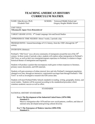
  • 1. TEACHING AMERICAN HISTORY CURRICULUM MATRIX NAME: Edna Kovacs, Ph.D. SCHOOL: Fernwood Middle School and Elizabeth Thiel Gregory Heights Middle School UNIT TITLE: Nihonmachi: Japan Town Remembered TARGET GRADE LEVEL: 8th Grade Language Arts and Social Studies APPROXIMATE TIME NEEDED: About 3 weeks, 2 periods a day PREREQUISITES: General knowledge of U.S. history, from the 1500’s through the 19th century OVERVIEW (Abstract): Portland’s “Old Town” was a diverse community of immigrants around the turn of the 20th century. In three weeks (2 periods a day), students will explore urban immigration to Portland’s Old Town, as well as their own immigrant/migrant experience to Portland, in relation to larger historical themes of immigration and migration. Students will produce a packet that encompasses multi genre written responses to literature, primary source documents, and GIS materials. Students will gain awareness of urban renewal, how and why Portland’s immigrant population changed over time, through an interactive, experiential scavenger hunt through Portland’s “Old Town” as well as investigative research into GIS census data. Students will meet Portland Public Schools standards in reading, writing, geography, history, and social studies. Students will be assessed according to the standardized procedure which examines academic success as well as effort. STANDARDS NATIONAL HISTORY STANDARDS: Era 6: The Development of the Industrial United States (1870-1900) Standard 2: Massive immigration after 1870 and how new social patterns, conflicts, and ideas of national unity developed amid growing cultural diversity Era 7: The Emergence of Modern America (1890-1930) Standard 1:
  • 2. How Progressives and others addressed problems of industrial capitalism, urbanization, and political corruption Standard 2: The changing role of the United States in world affairs through World War I PORTLAND SOCIAL STUDIES STANDARDS History 3. Students will know and understand the factors, experiences and impacts of historical and contemporary movements and settlements of people. 6. Students will know and understand the concept of culture and its relationships to region and place, and influences on cooperation and conflict. Citizenship 1. Students will examine and debate the concept of citizenship, specifically the roles, rights (individual and group) and responsibilities of the citizens of the United States. Fulfill Civic Responsibility 8. Students will participate in formal and informal activities to promote the well being of society Maps and Other Geographic Representations 1. Students will demonstrate their ability to use maps and other geographic representations to locate, organize and interpret information about people, places and environments. Global Economics 3. Students will understand, analyze and study the dynamics and impact of global economic relationships. LESSONS Lesson 1: Personal Immigration Stories Lesson 2: Understanding Key Terms Lesson 3: A Brief History of Portland to 1900 Lesson 4: Old Town Field Trip and Scavenger Hunt Lesson 5: Old Town Through the Eyes of Rose and Cherry Lesson 6: Primary Sources – Photographs Lesson 7: Primary Sources – U.S. Census Lesson 8: Primary Sources – Quotations about Japanese Experience Lesson 9: Crime in Old Town 1917 Lesson 10: Japanese Internment in Portland Lesson 11: Internment – Only What They Could Carry Activity Lesson 12: Portland – Then and Now Lesson 13: Tales of Old Town
  • 3. LESSON PLANS: Lesson 1: Personal Immigration Stories Objective: To introduce students to the idea of immigration through their own families’ history; to begin thinking about immigration as a factor in the development of our country and our culture. Materials: World map, finger paint, ArcView GIS software Procedure: Introduction: Ask students how they got to Oregon. Take several responses. For students who were born here, ask how their parents got here. For students whose parents were born here, ask how their grandparents got here. Extend the discussion to how students’ relatives first arrived in the United States. Tell students that when someone moves from one country to another, this is called immigration. Tell them that we will be discussing immigration for the next few weeks. Pair: Have students get with a partner. Have each student tell the other how his/her family came to the United States. Think of every country that your relatives immigrated from. Tell students to be ready to share this information with the class, and to find each country on a map or atlas. Share: Have each student come up and share with the class their family’s roots. Encourage students to tell a little about each relative, and why they came to the U.S. Each student can put a dot on the map with finger paint on the countries that their relatives immigrated from. Synthesis: Ask students to look at the completed map with all its dots, and look for any patterns. What other information would be interesting to know about these immigration stories? Extension: For students who are already ArcView savvy, have them code the class map into ArcView (see instructions). Modification: For students who aren’t sure where their relatives came from, give them an extra evening to go home and find out.
  • 4. ArcView 3.3 GIS Instructions: How to START ArcView Personal Immigration Story Project Click on the “Start” menu at the bottom left corner. Click on “Programs” then click on “ESRI.” Click on the “ArcView GIS 3.3” folder. Finally, click on the “ArcView GIS 3.3” program. A box that says “Welcome to ArcView GIS” should appear once the program launches. Click on the button for “Open an existing project.” Then click on OK.
  • 5. Navigate to the C: drive (double-click on the c: in the middle box). Navigate to the folder where a project called “personal immigration stories.apr” is located (ask your teacher). Double-click on the APR file (you should see it in the left box). What you should see is an outline map of the world and the United States. You can use this map view to place dots on the countries or states where your ancestors immigrated from.
  • 6. ArcView 3.3 GIS Instructions: How to IDENTIFY Countries and U.S. States This is the MAP. This is the LEGEND. Notice that there are two layers (also called THEMES) in the LEGEND (Countries of the World and United States). Both have checkmarks in the box to the left. This means that the layer is ON (it is drawing in the MAP area). If you click on the checkmark it will turn off and not draw in the map area. One theme looks a little different – it seems raised or popped out (Countries of the World). This means it is ACTIVE. If you want to find out the name of a country then the COUNTRIES OF THE WORLD layer must be ACTIVE. If you want to find out the name of a state then the UNITED STATES layer must be ACTIVE. All you need to do to make a theme ACTIVE is to click on the name of the theme.
  • 7. USING THE ID TOOL: This is the ID TOOL. Click on the ID Icon then click on a country (or State if the United States theme is active). Another window will pop up showing you all the available information about that country including its name. Hint: Use the ID TOOL to locate a country or state if you are not sure where it is on the map. Or, you can also use an Atlas.
  • 8. ArcView 3.3 GIS Instructions: How to Place a Dot on the Map Step 1: Choose your dot’s Style, Color and Size. Click on the word “Window” on the menu bar. Then click on “Show Symbol Window” in the middle. This will open another window where you can choose your dot style, color and size. Click on this icon to open up the POINT marker selections. In this area you can select the STYLE of your point. Scroll down using the bar on the right to see more choices. Use this drop-down box to select the SIZE of your point. A value of 10 is good for this exercise. Click on this icon to get into the color area. Here is where you can choose the COLOR of your point. Scroll down (the bar on the right) to see more color choices. Hint: You can close this Palette Window by clicking on the “X” in the far upper right corner.
  • 9. STEP 2: Place your Point on the Map These are the GRAPHICS Tools. Click and hold to get the drop down list. Click on the POINT. This makes your POINT the ACTIVE tool. Click on the map where you want your point to be placed. Notice the 4 black squares around your point (these are called handles). This means that this point is SELECTED. When a point is selected you can move it around using the mouse or delete it (using the DELETE key on the keyboard). If you want to move or delete a point that is not currently selected (it doesn’t have handles around it), click on the POINTER TOOL, then click on the point to select it. Hint: When a point is SELECTED you can also change its size and color. Look back in these instructions to see how to access the SYMBOL WINDOW. You may want to make increasingly bigger points to show where your ancestors journeyed on their way to Oregon. Or, you may want to have different color points to show countries or states where you have relatives.
  • 10. ArcView 3.3 GIS Instructions: How to LABEL your POINTS These are the TEXT TOOLS. Click and hold on the big “T” to get the dropdown list. Then click on the third option. This one will allow you to type a LABEL with a line attached to your point. STEP 1: Start at the point you STEP 2: Let go of the mouse want to label. CLICK, HOLD and and a TEXT BOX will appear. DRAG your mouse to draw a line Type in the LABEL (you can from the point to an empty space use the ENTER key to add on the map. lines). Then click on OK.
  • 11. Hint: You can select other kinds of label tools as well. Use the BANNER label to create a title for your map. Use the regular “T” or TEXT tool to type your name and the date on your map. Also, you can SELECT and delete labels if you want to change them. Use the POINTER TOOL to SELECT the label (when selected it will have the handles). Then you can use the DELETE key to erase the label.
  • 12. ArcView 3.3 GIS Instructions: How to SAVE and PRINT your Map SAVING YOUR MAP: Click on FILE on the menu bar. Click on SAVE PROJECT AS. In the next box (SAVE PROJECT AS) you will need to “navigate” to a place on the computer you can save files (ask your teacher). Then, in the FILE NAME area you should type your name or a name for your map.
  • 13. PRINTING YOUR MAP: Click on FILE on the menu bar. Click on PRINT. The PRINT box will appear. You will need to click on the SETUP button and choose an accessible printer (ask your teacher). Click on OK when finished. Choose an available printer here. Make sure that this is set to LANDSCAPE so your map prints out correctly.
  • 14. Lesson 2: Understanding Key Terms Objective: To introduce students to the terms that they will be using to think about immigration in Portland. Materials: Concept maps, Concept Map overhead, Creating America Procedure: Introduction: On the chalkboard, write the following terms: • Immigration • Urbanization • Migration Patterns • Support Society • Urban Renewal • Industrialization Tell students that they will be using these terms to learn about immigration in Portland, so it is important that everyone have a good understanding of what these terms mean. Concept mapping: Hand out enough concept maps for each student to have one for each term. Use the Concept Map overhead to guide students as they make a concept map of the first word. Ask students to help fill in the map. Map each word together as a class, having students come up to share their work on the overhead. Historical Background: Ask students to read Creating America Chapter 21.1, which discusses immigration in the late 19th century. Have students answer the Section Review Questions. Discuss these questions as a class. Synthesis: To close, discuss with students the similarities and differences between what they read and thought about today, and the stories about their families that they shared yesterday.
  • 15.
  • 16. Lesson 3: A Brief History of Portland to 1900 Objective: To give students the background needed to understand how profoundly immigration affected Portland around the turn of the century. To share with students the history of their city. Materials: Powerpoint Presentation—derived from “Portland Project” CD; Creating America Procedure: Introduction: Tell students that to understand the impact that immigration had on Portland, they need to know a little about Portland before the great immigration waves of the turn of the century, Presentation: Power Point using historic images of Portland. Discuss with students the history of Portland, from its inception in the 1830’s until the 1900’s. Point out existing landmarks, buildings, streets. Silent Reading: Read Creating America 21.2 (industrialization). Have students answer section review questions. Synthesis: Have students compare what they read in their text book with what they learned and know about Portland. How does Portland compare with other industrializing cities? Lesson 4: Old Town Field Trip Objective: To give students a first-hand knowledge of Portland history, and to see how Portland’s history is still alive today. Materials: Scavenger Hunt Packets, Field Trip Itinerary Procedure: Take bus/MAX downtown Walking Tour or historical Old Town/ Urban Renewal (see scavenger hunt packets) Visit Jewish Museum—presentation by director Lunch Visit Nikkei Legacy Center/ Japanese Memorial—presentation by staff Tour of Old Japan Town (Echoes, echoes, echoes!) Return to School
  • 17. Old Town Chinatown PPS Student Field Trip Itinerary Background Portland Public Schools teachers Edna Kovacs and Elizabeth Thiel, as a component of their Teaching American History curriculum units, are developing a field trip template for middle school teachers in the Portland area. The field trip encompasses what is known as Chinatown, Old Town, and a portion of the Pearl District. The emphasis of the day’s activities is to provide the students with understanding and appreciation of the region’s rich cultural and architectural heritage. With time constraints, it will only be possible to visit and tour select sites within the region, but the sites selected broadly represent the multicultural and multiuse nature of the area. As a tactic to maintain student engagement throughout the day, as well as serving as a learning tool and producing student work, the students will be given a “guide” for the day’s activities. This guide will provide a brief history of the region, information about significant sites, field trip tour route, and a historical “scavenger hunt” component. The students will be required to turn in their completed handout to PPS teachers following the field trip. Dates: May 17 (Monday), May 19 (Wednesday), May 20 (Thursday) Itinerary (same daily) 10:10 – 10:30 Zimmerman Community Center Students will learn about the tremendous revitalization of the area, and preview the day’s activities. Starbucks refreshments. 10:30 – 11:30 Walking Tour, Part One Urban Change, Renewal in the Pearl and Old Town 11:30 – Noon Oregon Jewish Museum Judy Margles or representative will discuss the Jewish presence in the neighborhood and Portland in general. 12:15 – 1:10 Old Town Pizza Company The Old Town Pizza Company is housed in a former brothel and gambling parlor. 1:15 – 1:35 Oregon Nikkei Legacy Center Presentation by an ONLC representative relating to the Japanese community in Old Town and the subsequent internment. Students will view exhibit as well. 1:45 – 2:00 Japanese Internment Memorial at Waterfront Park An ONLC representative will lead the students from ONLC to the memorial and discuss the significance and meaning of the memorial. 2:10 – 2:45 Japantown Walking Tour, Part Two Guided walk through significant sites to the Japanese community. 3:00 Walking Tour, completion (segment two) Enroute to the MAX station, students will complete the Old Town Walking Tour.
  • 18. PORTLAND STUDENT WALKING TOUR Historical Scavenger Hunt Activity Worksheet STARTING POINT: Zimmerman Community Center or Park Blocks Part One, Segment One: 1. NW 10th Avenue & Glisan (looking north) • How has the area around this intersection changed since c.1920 photograph? • Do any of the same buildings remain? • What is this process of city development called? 2. NW Glisan & Park. Note the cobble streets and trolley tracks, now covered over by asphalt. This layer of street can still be seen in certain parts of town where asphalt is coming loose. 3. Broadway & Everett Golden West Hotel • What is the significance of this hotel to early Portland history? • Who ran the barber shop? • Who was the hotel proprietor? 4. Broadway & Everett (looking south) • What building is this? • Why did the river flood downtown as shown in the photograph? 5. NW Couch & 6th Avenue. Former brothel (top story) and grocery (bottom story) ran by an “oriental couple” who ran both from 1920-1940. 6. Burnside at 5th Avenue (looking west) • How is it different today? • Do you recognize any of the same buildings? If so, which ones? 7. 69 N. 4th Avenue. Bow Yen Grocery & Dry Goods was also a gambling hall. It was turned into a city parking lot in order to provide tourist parking and clean up of “blighted” buildings. • This type of city development would be called what?
  • 19. PORTLAND STUDENT WALKING TOUR Historical Scavenger Hunt Activity Worksheet 8. 4th Avenue & Davis. Hop Sing Tong Headquarters. Fong Chong now at the site. • Why were tong associations important within the Chinese-American community? 9. 310 NW Flanders. Hotel American in back and Royal Palms Hotel in front. Provided rooming houses for the railroad and logging workers. • What is the Hotel American site presently? 10. Union Station (train station) • What is the architectural style of the station? • When was the station constructed? Part One, Segment Two: 11. Erickson’s Saloon, 5 NW 2nd Avenue. Important social spot for Portland laboring class and immigrants. • Why did Erickson’s give “free meals” to its patrons? • How was it that the bar became world famous? 12. Ballis Dock Building, 1st & Burnside. Moved during the widening of Burnside Street. • What is the building now used as? 13. New Market Theater, 50 SW 2nd Avenue. C.1873. “There was no ‘amusement palace’ so elegant north of San Francisco” at the time. • Why was cast iron prefab facades used for early Portland buildings? • In 1869 the Ankeny Block held a record for what?
  • 20. PORTLAND STUDENT WALKING TOUR Historical Scavenger Hunt Activity Worksheet Part Two: Japantown A. Mikado Bath, 306 NW Everett. The entrance to the community bath, now closed, leads to the basement of what used to be the Mikado Hotel. The bathhouse has a large communal bath for men and a separate smaller one for women. Men’s bath was 7x15 feel across, like a small pool. B. Mary’s Café, NW 3rd & Davis. Ran by two Issei men serving western-style food, pancakes, steaks and potatoes. C. Foster Hotel, 216 NW 3rd Avenue. It was significant to Japantown in that many of the tenants were Japanese workers. D. Mr. Daiichi Takeoka’s Law Office, 208 NW 3rd Avenue. Mr. Takeoka graduated from the University of Oregon law school, but could not practice law legally as an Issei. He was used by the community for legal consult. He also led the community in an effort to repeal the Oregon Alien Land Laws of 1924 and 1946, laws which prohibited Issei from owning land and working on farms. E. Judo Obukan, 219 NW Davis. This served as a citywide Obukan Judo club. This club often held tournaments with clubs from Salem, Seattle, Hood River, etc. F. Oshu Nippo, 131 NW 2nd Avenue. This was the Japanese Daily Newspaper. It has 8-10 employees who ran the paper on an old printing press. This newspaper was the only communication link for Japanese Issei and the outside world at the time. G. Merchants Hotel, 123 NW 2nd Avenue. The Merchants Hotel covered an entire ½ block. It was the heart of Japantown. H. Matsubu Laundry, 121 NW 2nd Avenue. The laundry served two purposes – clean soiled laundry and provide bath services for workers. Typically workers would take a weekly bath and get their clothes laundered at the same time, in preparation for weekly leisure time with their friends. I. Oregon Nikkei Legacy Center, 117 NW 2nd Avenue. Center for Japanese Cultural and Heritage in Portland. Exhibits, educational programs, and collections for community posterity.
  • 21. OREGON JEWISH MUSEUM Scavenger Hunt Worksheet 1. What year was the first Jewish wedding between two native Oregonians? 2. What Oregon woman fought to win the right to vote? 3. Which Rabbi got caught with golf clothes under his robes? 4. What happened to the second Congregation Beth Israel building? 5. Who worked extensively with Braille in the Beth Israel Sisterhood and met Pat Nixon and Julie Eisenhower?
  • 22. OREGON NIKKEI LEGACY CENTER Scavenger Hunt Worksheet 1. Find the name of a Japanese business in Nihonmachi before the War. 2. Find the Notice that required Japanese Americans to go to the Portland Assembly Center. What date were they required to be at the Assembly Center? 3. What is contraband? Find the display case where contraband is located and find one contraband item. 4. List the names of two people that helped Japanese Americans during relocation to the Assembly Center. 5. List items people were allowed to bring to the Assembly Center. 6. Name three jobs that people had at the Assembly Center. 7. Name recreational activities at the Assembly Center. 8. Identify the name of the Japanese American newspaper at the Assembly Center. 9. Where did some people go after the Assembly Center?
  • 23.
  • 24.
  • 25.
  • 26.
  • 27.
  • 28.
  • 29.
  • 30.
  • 31.
  • 32.
  • 33.
  • 34.
  • 35.
  • 36.
  • 37.
  • 38.
  • 39.
  • 40.
  • 41.
  • 42.
  • 43.
  • 44.
  • 45.
  • 46.
  • 47.
  • 48. Lesson 5: Old Town through the Eyes of Rose and Cherry Objective: For students to relate their experiences on yesterday’s field trip to literature, history, and geography through mapmaking. Materials: “Flower Girls” Reading (see resources for citation); Old Japan Town through the Eyes of Rose and Cherry Handout Procedure: Introduction: Tell students that today we will be reading a story that takes place on the very streets where they walked yesterday. Read Aloud: Have the class play “readers tag” as you read “Flower Girls” by Lawson Inada. Ask students to take out a highlighter and highlight the names of places as they are read in class. Mapping: See “Old Town through the Eyes of Rose and Cherry” handout. Have student follow the directions on the handout. Use an overhead map of Nihonmachi to assist students in locating the streets and avenues. Synthesis: When students have had time to work on their maps, ask volunteers to point out features on the map that they saw yesterday. Discuss the “reality” of the story, and how we know what we do know about how Old Japan town used to look.
  • 49. Name ________________________________________________________________________ Japan Town through the Eyes of Rose and Cherry Directions: Label the following streets on the map of Japan Town: NW Couch St. NW 1st Ave. NW Davis St. NW 2nd Ave. NW Everett St. NW 3rd Ave. NW Flanders St. NW 4th Ave. NW Glisan St. NW 5th Ave. NW Irving St. NW 6th Ave. Burnside St. NW 9th Ave. NW 10th Ave. NW 11th Ave. Shade in the area that was considered Japan Town (between 2nd and 6th Avenues, and between Burnside and Glisan Streets). Draw a symbol for each of the following places. Put this symbol on the map in the correct place and on your map key. Union Station – Irving Street between 6th and Broadway Atkinson School – 11th and Davis Mikado Baths – 306 NW Everett St. Oshu Nippo Newspaper Office – 131 NW 2nd Ave. Blitz Weinhard Brewery – 10th and Flanders Japanese Dance Studio – 322 NW 3rd Ave. Pick 5 more places that Rose and Cherry visited in Old Japan Town and place them on the map where they might have been. Draw a symbol for those places on the map and on the map key. Draw the kappa, as you imagine him in or near the Willamette River. Draw the route of Rose and Cherry doing “the regular things.” Color your map and make sure everything is labeled and listed in the map key.
  • 50.
  • 51. Lesson 6: Primary Sources - Photographs Objective: Students will glean historical information and make inferences from photographs; to begin the brainstorming process for fiction writing. Materials: Photographs from Old Japan town—at least 1 per student (OHS or Nikkei Center are good sources for photographs). Procedure: Introduction: Ask students to think of ways that we can know about what Old Town Portland was like in the past. Discuss several ways (first hand accounts, photographs, history books). Tell students that this week, they will begin working on a short story that takes place in Old Town Portland, and they will be using various primary sources to inform their stories. Review what a primary source is. Tell students that today, we are going to be looking at one kind of primary source -Photographs. Model: On the overhead, put a high interest historical photograph of Old Town Portland. Ask students what they see. Discuss how we can learn about the past through photographs. Ask students to list things they can know about the past from this photograph. Have a student list these things on the board. Then have students think of things they can infer from this image. Discuss the difference between knowing and inferring. Tell students that they will be doing the same thing on their own. Individual Work: On students’ tables, lay out photocopies of photographs of Old Town Portland, enough for each student to have one. Direct students to each pick one photograph. Students should study their photograph, and use it to try to understand an aspect of life in Old Town Portland. On a separate sheet of paper, each student should list 5 things they can know from the photo, and 5 things that they can infer from the photograph. When they have done this, they should write a 1-2 page character sketch of a person in their photo. They should include physical characteristics, relationships, activities, personality, etc. Remind students that of course, they can’t get all this information from the photo; they will have to use their imaginations. Synthesis: For the last 10 minutes of class, have students share the character sketches they are working on. Have them finish these at home, if necessary. Tell students that they will be using these character sketches in a short story that they will be writing.
  • 52. Lesson 7: Primary Sources – U.S. Census Objective: To introduce students to GIS, and how we can use it to learn about history, and in particular, about Old Town Portland. Materials: 1930 Old Town Census ArcView Project; Infocus projector; GIS teacher instructions and student instructions/worksheet Procedure: Introduction: Remind students of yesterday’s discussion of “primary sources.” Yesterday, we looked at photographs. Tell students that today, they will begin looking at another primary source—the 1930 U.S. census data for Old Town. Explain what a census is, how often they are taken, and why they are taken. Explain that this data has only recently been formatted to look at using a special software called GIS. Presentation: Using a projector, show student the 1930 census data for Old Town, prepared in an ArcView GIS project. Demonstrate how to use the software to learn about the people of Old Town. Tell students that they will have a chance to explore this data themselves. Writing Assignment: Tell students that they will be using the information from the 1930 census, as well as their photographs from yesterday, and other primary source information, to write a fictional story that takes place in Old Town. Hand out Old Town Story rubric, go over it with the class, and assign due dates for the 1st, 2nd, and 3rd drafts. Tell students to use their character sketches (Lesson 6) as a basis for their story, and use the census information to give specific information about people and places that their character may have encountered. Individual Work: Have students get in pairs/triads to complete the “GIS” worksheet. If there are not enough computers for everyone to work, tell students that they will all have a chance throughout the week. Students who are not able to get on a computer today should continue working on their short story.
  • 53. OLD TOWN AND JAPANTOWN: EXPLORING THE 1930 CENSUS DATA USING GIS TEACHER GUIDE FOR U.S. CENSUS ARCVIEW DEMONSTRATION To Launch ArcView and Open the US Census Project: 1. Click on the “Start” menu at the bottom left corner. Click on “Programs” then click on “ESRI.” Click on the “ArcView GIS 3.3” folder. Finally, click on the “ArcView GIS 3.3” program. 2. A box that says “Welcome to ArcView GIS” should appear once the program launches. Click on the button for “Open an existing project.” Navigate to the C: drive (double-click on the c: in the middle box). Navigate to the folder where the project called “oldtown1930census.apr” is located. Double-click on the APR file (you should see it in the left box). What you should see are sections of old fire insurance maps (Sanborn maps) hand-drawn in 1932. You should also see blue dots which represent people living in this area according to the 1930 U.S. Census. The area that shows on the screen is Old Town in downtown Portland. Learning about GIS and Spatial Data: The Map View 1. Explain that GIS means Geographic Information Systems. It is a way to use a computer to visualize information about the places that we live (our geography). Looking at these kinds of “maps” should be familiar – remind students of the World Map exercise, the field trip and their Japantown map activities. 2. Explain that the “layers” on the left (in the Legend) are called THEMES in GIS. Themes represent different kinds of geographic data. Different themes could be streets, rivers, parks, schools, etc. Ask students if they can think of other kinds of “themes” that they might have seen on a map (i.e. physical features such as soil types, etc.). 3. Turn the themes ON/OFF (using the checkmark to the left of the theme) to show how the computer draws the themes and also explain ACTIVE/INACTIVE (clicking on the theme name makes the theme “pop out” a bit – this means that it is ACTIVE). A theme needs to be ACTIVE in order for the computer to know which theme that you want to find out information or ask a question about. The Data Behind the Map: 1. Explain to students that there is lots of information “behind” the picture that they see in the Map View. Open the Theme Table for the 1930 Oldtown Census Data (make sure that this layer is ACTIVE).
  • 54. 2. Scroll across the table to show students the kind of information that the Census collected in 1930 (these are the Columns). Refer to 1930 Census Metadata Sheet (found in the Nihonmachi folder) for what the column headings mean (e.g. Hv_cmr = Value of Home or Monthly Rent). You can find an unusual piece of information (e.g. Radio) and ask students why they might think that the U.S. Census would be interested in such information. What would they do with that information? Do the students think that this same information is still collected today? Tidbit: The government is interested in finding out how many people have access to technology. In 1930 it was the radio. More recently, census questions ask about telephones, televisions and computers. 3. Scroll down the table to show students how many RECORDS (or rows) there are in the table. Each record translates to a point on the map and represents each person living in Old Town in 1930. You can find the total number of records in the upper right corner (there are 2188 records in this dataset). Asking Questions using GIS: Zooming in to an Area of Interest 1. Use the MANUAL ZOOM IN Tool to take a closer look at the block from Davis & Couch and 2nd Avenue (see graphic below). This is the heart of Japantown that the students visited on their fieldtrip. Click on the MANUAL ZOOM IN tool to make it active. Starting from the upper right corner of the block, click-hold-drag the mouse to draw a rectangle around the area you want to zoom in to. When you let go the computer will zoom in to the area you defined. THE OOPS KEY! If you make a mistake and want to return to where you were before, click on this tool and it will take you backward one step (you can click on this tool several times to go backwards even more). 2nd Ave.
  • 55. 2. Ask the students if they recognize any of the sites that they visited on their Japantown Walking Tour. Hint: The Oshu Nippo Print shop is on the SW corner of Davis & 2nd and the Merchants Hotel is on the SE corner of Davis & 2nd. The Matsubu Laundry & Bath is on the NW corner of Couch & 2nd. Other general information about the Sanborns if students ask (a more detailed Sanborn key is located in the Nihonmachi folder): • Color codes refer to the building type (red=tile or brick; yellow=wood frame; blue=concrete) • Letter codes (S=storefront; A=outbuilding) • Floors – the number of floors can be identified by a number in the corner of the building section. 3. Ask students if they notice a pattern in the points. Hint: Most of the points are CLUSTERED in certain areas on the map. This is where you can explain how to determine the number of floors in the building (they range from 3-8 floors). The points are clustered because most of the buildings had storefronts, restaurants and other facilities on the lower levels and lodging/rooms on the upper floors. The clusters of points are the people that lived in the upper level rooms (with data this old, it was impossible to locate the points exactly where the people lived in the building, there were no apartment numbers for reference). Asking Questions using GIS: Using the ID Tool to Look at Specific Information 1. Click on the ID TOOL to make it active. With this tool you can look at the actual data for each of the people (points) shown on the map. Use the cursor to click on one of these dots (Hint: it will be more effective to choose an isolated point, rather than one located in a large cluster of points). 2. Use this “Identify Results” window to look at the various pieces of information available for this individual. You can look at age, marital status, occupation, etc. Refer to the US Census Metadata for what each piece of information means or have the students look at the metadata as you identify an attribute from the ID window. (e.g. “It says here that this person’s RACE was FIL. Look at your Metadata Sheets and tell me what that means.)
  • 56. Asking Questions using GIS: How to QUERY the US Census Dataset: We know that this was an immigrant neighborhood (in the heart of Japantown). We want to find out how many of the people living in these few blocks could speak English. This question will serve as an illustration of the query process. In the student instructions, the students will use this same tool to isolate the Japanese residents. 1. Close the “Identify Results” window by clicking on the “X” in the upper right hand corner. 2. Click on the QUERY TOOL to make it active. The QUERY window will open. You will use this window to construct your question. 3. In the box marked “FIELDS,” double-click on “ENG.” Then single-click on the “=” sign in the middle. In the box marked “VALUES,” double-click on “Y” which says English=Yes (according to the US Census Metadata, this means that this person could speak English). IMPORTANT: The box at the bottom should now say exactly the following: ([Eng] = “Y”). If it does not then you will need to close the window (“X”) and start over. 4. Click on NEW SET. All the points (persons) that can speak English (ENG=Y) are now in yellow (that means they are selected). 5. Open the THEME TABLE to show how the records in the table have turned yellow (selected) as well. Scroll around the table to see how many of those persons born in Japan (BIRTH column) could speak English. Are there lots of English-speaking Japanese?
  • 57. A Few Navigation Tools: Conclude the demonstration with a few navigation tools. 1. Close the Theme Table (“X”). Click on the ZOOM TO ACTIVE Tool (the middle tool on the navigation bar). This will zoom the map to the spatial extent of the ACTIVE theme (1930 Oldtown Census). 2. Show the students the PAN Tool . Click the Pan Tool then click-hold-drag the map. Close the ArcView project by clicking on the “X” in the far upper right corner of the Program’s window. Do not save (so that the project will open properly next time).
  • 58. OLD TOWN AND JAPANTOWN: EXPLORING THE 1930 CENSUS DATA USING GIS STUDENT INSTRUCTIONS AND WORKSHEET To Launch ArcView and Open the US Census Project: 1. Click on the “Start” menu at the bottom left corner. Click on “Programs” then click on “ESRI.” Click on the “ArcView GIS 3.3” folder. Finally, click on the “ArcView GIS 3.3” program. 2. A box that says “Welcome to ArcView GIS” should appear once the program launches. Click on the button for “Open an existing project.” Navigate to the C: drive (double-click on the c: in the middle box). Navigate to the folder where the project called “oldtown1930census.apr” is located (ask your teacher). Double-click on the APR file (you should see it in the left box). What you should see are sections of old fire insurance maps (Sanborn maps) hand-drawn in 1932. You should also see blue dots which represent people living in this area according to the 1930 U.S. Census. The area that shows on the screen is Old Town in downtown Portland. Zoom in to this block.
  • 59. Using ArcView Tools to Explore the U.S. Census Data: 1. Look at the map and zoom in to the block with Couch to the north, Burnside to the south and in between 2nd and 3rd Streets. You can also choose another block that looks interesting to you. Here’s how you zoom…Use the ZOOM IN Tool to take a closer look at this block. Click on the tool to make it active. Starting from the upper right corner of the block, click-hold-drag the mouse to draw a rectangle around the area you want to zoom in to. When you let go the computer will zoom in to the area you defined. You can see that these maps were drawn in great detail. THE OOPS KEY! If you make a mistake and want to return to where you were before, click on this tool and it will take you backward one step (you can click on this tool several times to go backwards even more). Here’s the ID Tool. 2. Click on the ID TOOL to make it active. With this tool you can look at the actual data for each of the people (points) shown on the map. Use the cursor to click on one of these points. On the “People in Japan Town” worksheet, write down the name and address of the person you clicked on (this will be Person 1). The census data tells us a lot about the people who were living in Old Town in the 1930s. Besides names and addresses, the data tell us about the race, occupation, language spoken as well as their birthplace, the birthplace of their mother and father and even whether or not they could read.
  • 60. 3. Use the data table you opened with the ID TOOL to find out three more facts about the person whose name you just wrote down. Use the US Census Metadata sheet to figure out what each piece of information means. Write these facts in Section A on your worksheet. 4. Close the current “Identify Results” table (click on the “X” in the upper right hand corner). 5. Repeat Steps 2-3 to learn about 2 more people living in Japantown in 1930. Fill in the remaining information in Section A on your worksheet. Asking Questions using GIS: How to QUERY the US Census Dataset: 1. We know that this was an immigrant neighborhood. You may have discovered that people came from many different countries. We want to find those persons of Japanese ancestry. You can use the QUERY TOOL to ask this question and locate the Japanese in Old Town. 2. Click on the QUERY TOOL to make it active. The QUERY window will open. You will use this window to construct your question. 3. In the box marked “FIELDS,” double-click on “RACE.” Then single-click on the “=” sign in the middle. In the box marked “VALUES,” double-click on “JP” (according to the US Census Metadata, this means “Japanese”). IMPORTANT: The box at the bottom should now say exactly the following: ([Race] = “JP”). If it does not say this then close the query window (“X”) and start over. 4. Click on NEW SET. All the points (persons) that are Japanese (RACE=JP) are now in yellow (that means they are selected).
  • 61. 5. Use the ID TOOL to learn about some of these people of Japanese ancestry. Write down the name, age, and occupation of 3 of these people in Section B on your worksheet. 6. Use the Navigation, ID and Query Tools to answer the questions in Section C and D on your worksheet. The Quick Reference Guide below will help you to locate the tools.
  • 62. Name ________________________________________________________________________ PEOPLE IN JAPAN TOWN – 1930 Follow the instructions for using ArcView to learn about Japan Town in the 1930s. Fill in the information below. A. Using the ID TOOL: People Living In Japan Town Person 1 Person 2 Person 3 Name: Name: Name: Address: Address: Address: 3 Facts: 3 Facts: 3 Facts: 1. 1. 1. 2. 2. 2. 3. 3. 3. B. Using the QUERY BUILDER: People of Japanese Ancestry in Japan Town in 1930. Name: Name: Name: Age: Age: Age: Occupation: Occupation: Occupation: C. Exploring the Data Tables. There were people living in Japan Town from all over the world. Find people living in Japan Town who were born in 5 different countries and list them below: Name Country of Birth 1. 2. 3.
  • 63. 4. 5. D. Look carefully at the Sanborn Maps. Zoom in to get a closer look, and use the PAN hand to navigate around the page. Find the names and addresses of at least 5 businesses in Japan Town. Business Address 1. 2. 3. 4. 5. E. Go back to your seat and summarize what you have learned from exploring this data. How could you use some of this information in the story you are writing? ______________________________________________________________________________ ______________________________________________________________________________ ______________________________________________________________________________ ______________________________________________________________________________ ______________________________________________________________________________ ______________________________________________________________________________ ______________________________________________________________________________ ______________________________________________________________________________
  • 64. Lesson 8: Primary Sources - Quotations about Japanese Experience Objective: For students to glean historical information and make inferences from people’s first hand experiences with history; To make connections between various sources of information. Materials: Quotations about Japan Town and Internment, cut into strips of paper. Procedure: Introduction: Tell students that today, we will be focusing on another primary source of historical information—people’s first hand accounts of history. On the overhead, write the following directions: 1) Pick a Quote that speaks to you. 2) Rewrite it neatly and large on a clean sheet of paper. 3) Illustrate your quote, using images and symbols to capture the meaning. Tell students that the quote they pick will also work its way into their story. Individual Work: On each table or cluster, place more that enough quote-strips for each student to have one. Instruct students to read several quotes prior to choosing one. As students follow the directions, provide white paper, rulers, and colored pencils. Writer’s Workshop: Allow students time to continue working on their short stories. Remind them that the quote they chose today should become a part of their story. Discuss ways to do this. Students may work on their self-evaluation or their second draft if they are ready. Synthesis: Have a few students share their illustrations and quote with the class. Have a few students articulate how the quotes added to what they know about Old Town, and how it will work into their story. *** As students work on this assignment, others may be on the computer completing the GIS assignment. Extension: Explore writing Japanese forms of poetry – haiku, renga, waka – while listening to Japanese shakuhachi music.
  • 65. QUOTATIONS FROM ISSEI AND OTHERS* The following quotations from Issei, U.S. Government officials and government documents can be used as resources for examining predictions in the Issei inquiry activity. These statements can also be used independently as prompts for stories, role plays and individual investigations. A. Immigrant and Settlement Related topics: immigration, alien, discrimination, picture bride, citizenship, Issei, Nisei “I hope that you summon your wife and make a peaceful home in this great land of freedom.” (Masuo Yasui) “According to what people said, in America money was hanging from the trees and one could rake up treasure like fallen leaves.” (Kunitaro Tanabe) “I saw that all the people has white skin and hair of different colors! I thought I had landed here by mistake! And I was troubled when I could not understand them. I truly wondered, ‘For what purpose did I come here?’” (Hisa Wakamatsu, The Hood River Issei) “We worked ten hours a day and made $1.15, out of which 10 cents was withheld as employment commission. White workers got $1.45 per day…The section life at that time was very crude. Between six and ten people were living together per section…” (Inota Tawa) “Sweat of pioneers turned these wide wilderness fields into fertile land. All the while deep injuries and insults were endured.” (Katsuko Hirata) “The Alien Land Law is now strangling us with its devilish hands…Japanese farmers might disappear from Oregon within the next twenty years, unless the Nisei can successfully take over.” (Kohei Oana, May 14, 1923). “There was a room where we met our prospective husbands. Men wore regular suits and all the women wore kimono. Fuji-san [Mr. Fuji], who had lived in our neighborhood in Hiroshima, introduced me to Papa [husband]…He asked me, ‘Are you satisfied that this man matches your picture?’ I said, ‘Yes.’ I guess Papa also said, ‘All right.’ Papa wore a white summer suit with black stripes. He was much thinner than his pictures, but I supposed this was due to hard work.” (Asayo Noji, The Hood River Issei) “Women’s work never ended. During the week, I labored in the fields. I drove the Ford tractor when we sprayed. Sometimes I even sprayed. Same as the men, I worked until 6:00pm. But when I came home, I had to cook too. After dinner during harvest, we boxed the fruit. Then when everyone went to bed, I cleaned the house. I heard of others who rose so early, they slept with their shoes on! Even on Sundays, I had laundry and housecleaning chores.” (Hatsumi Nishimoro, The Hood River Issei)
  • 66. “[In 1891] there were seven Japanese-owned restaurants in Portland…These restaurants served meals at 15 cents…I asked [Issei businessmen] ‘why did they choose the restaurant business?’ They answered, ‘It requires only a small capital to start with, about $400 to $500, and it brings back a quick profit.’ Lacking capital, the proprietors usually formed a partnership to start their restaurants.” (Japanese diplomat) “Children in English, parents in Japanese. It’s all Greek to both of us.” (Shizan Matsumoto) “The education of our children was our foremost goal. We tried to do a lot of the work ourselves to save for our children’s higher education. Hakujin [Caucasians] may have felt that we spent our lifetimes working and denying ourselves conveniences. But we felt education was so important that nothing else mattered. It was most satisfying to be able to send our children to school and know today that they are doing well.” (Tei Endow, The Hood River Issei) B. World War II Internment Related topics: incarceration, assembly center, internment, prejudice, due process, Constitution “We were all terror-striken at the news. War between America, where we would live until death, and Japan, where I came from! I am a Japanese subject, but my children are Nisei and American citizens.” (Hitoshi Nakamura) “The Japanese race is an enemy race…the racial strains are undiluted…The very fact that no sabotage has taken place to date is a disturbing and confirming indication that such action will be taken.” (Lt. Gen. John L. DeWitt, Commander General of the Western Defense Command) “About three days after Pearl Harbor, four FBI men came to our farm and spent three hours searching for contraband. We had been required to take to the courthouse our dynamite, guns, bullets—anything considered dangerous. While we thought we had turned in everything, the authorities found one small bullet in the woodshed. This caused them to take my husband even though he had been pruning [trees] outside and was still wearing his boots.” (Hatsumi Nishimoto, The Hood River Issei) “I cannot speak for others, but I myself felt resigned to do whatever we were told. I think the Japanese left in a very quiet mood, for we were powerless. We had to do what the government ordered. In my own mind, I though, ‘Surely we will be unable to return.’ I was so worried about what the future held for my children! We had struggled for many years, but we could lose everything. I was so frightened I actually did not think we would come home alive.” (Misuyo Nakamura, The Hood River Issei) “I remember seeing a large cactus when our train stopped at a field near Pinedale, so I guessed that we had arrived at a hot place. We were completely fenced in, and there were watchtowers with soldiers bearing rifles. We felt like prisoners!” (Itsu Akiyama, The Hood River Issei)
  • 67. “The odor was so bad! One-foot by six-foot planks had been laid over the stable floor, but there were plenty of smells left and lots of flies. After all, this [Portland Assembly Center] was where the horses had lived!” (Masaji Kusachi, The Hood River Issei) “Rounded up In the sweltering yard Unable to endure any longer. Standing in line Some collapse.” (Shizue Iwatsuki) “Black smoke rolls Across the blue sky. Winter chills our bones. This is Minidoka.” (Shizue Iwatsuki/Lawson Inada) “I do not recall any pleasant experiences in camp—not even one. What bothered me most was that there was virtually no family dining. Young people ate with their friends, men dined together, and women ate in their own groups. Perhaps one positive thing about camp was that life was scheduled—without questions, everything occurred on time. But then, if you did not go to the bathroom early, all the hot water would be gone. And early in the morning, there were many people. ‘All the time run out of hot water!’ On the other hand, life in camp could be described as happy, because we had time on our hands and could attend classes for free.” (Hatsumi Nishimoto, The Hood River Issei) “The biggest difference in camp was that we lost our freedom—we were not free to do what we wanted. It was kind of a lonesome feeling when we had to leave home for camp…Shikata-ganai [It is beyond control; it cannot be helped; so accept it as it is]. We had the feeling that we all had to work together.” (Hama Yamaki, The Hood River Issei) “Will you swear unqualified allegiance to the United States of America and faithfully defend the United States from any or all attack by foreign or domestic forces, and forswear any form of allegiance or obedience to the Japanese emperor, or to any other foreign government, power or organization?” (U.S. Government loyalty questionnaire, Question 28, February and March, 1943) “You fought not only the enemy, but you fought prejudice—and you won. Keep up with that fight, and we will continue to win—to make this great republic stand for what the Constitution says it stands for: ‘The Welfare of all the people all the time.’” (President Harry S. Truman, saluting the Nisei soldiers, July 15, 1946)
  • 68. C. Post-War Resettlement Related topics: discrimination, citizenship, civil liberties, Constitution “My hope is that Nisei and Sansei live an honest life in harmony with Caucasian neighbors and make a significant contribution to American life.” (Asayo Noji, The Hood River Issei) “Through the car window A glimpse of pines, Oregon mountains. My heart beats faster, Returning home.” (Shizue Iwatsuki) “When I returned, I found my home had been ravaged. All that was left of our furnishing was the kitchen stove. We had also left many belongings in a locked room, but the locks had been broken. Everything was stolen! And the condition of our orchard was deplorable! Limbs were hanging down so low that you could pick the fruit sitting down—you could! It was bad enough to discover that our home and orchard were in terrible condition. But when our caretaker presented us with a bill for $1,700, that was a terrible blow!” (Masaji Kusachi, The Hood River Issei) “We rose early in the morning to cut asparagus and devoted the rest of the day toward recovery of our orchard. In the evening after dinner, we packed our asparagus for shipment. I do not ever recall going to bed any earlier than midnight in those days. What I remember most was that, although we were faced with hard work, we found inspiration in our efforts to restore our orchard. I am still amazed that we had such ambition. Our children became so involved that they did not even complain about the hard work.” (Itsu Akiyama, The Hood River Issei) “My son George was still in his army uniform when he entered a barbershop downtown. He was refused a haircut. He heard that the barber commented, ‘I should have cut that Jap’s throat.’ Another patron, Captain Sheldon Laurence, paid us a visit later and apologized for George’s treatment.” (Itsu Akiyama, The Hood River Issei) “We asked Mr. or Mrs. Moore to make purchased for us, and we waited for them in their store. The Moores were most friendly toward the Japanese, and we had great feelings for them.” (Hatsumi Nishimoto, The Hood River Issei) “When I lived in Japan, I was still a young person and could not vote. So when I attained citizenship in this country and voted for the first time, I felt GREAT! Afterward I realized that with citizenship and voting privileges also came certain responsibilities, like paying taxes…Now, though, as a citizen I could finally own land!” (Masaji Kusachi, The Hood River Issei)
  • 69. “The several hundred alien Japanese to whom the Alien Land Law is applicable came to our state lawfully under laws enacted by Congress. They are here lawfully and are entitled to remain. Many of them are parents of United States citizens. And some of them are mothers and fathers of American soldiers who gave a good account of themselves in the recent war.” (Oregon Supreme Court, 1949) “The evacuation and incarceration of Japanese were ‘carried out without adequate security reasons and without acts of espionage or sabotage…and were motivated largely by racial prejudice, wartime hysteria, and a failure of political leadership.’” (U.S. Civil Liberties Act of 1988) “With new hope, We build new lives. Why complain when it rains? This is what it means to be free.” (Lawson Inada) *Quotations are from the exhibit, In This Great Land of Freedom: The Japanese Pioneers of Oregon, and from Linda Tamura, The Hood River Issei: An Oral History of Japanese Settlers in Oregon’s Hood River Valley, Champaign, IL: University of Illinois Press, 1993.
  • 70. Lesson 9: Crime in Old Town, 1917 Objective: To show students how historical information, such as arrest warrants, can add to our understanding of a time in history; to form generalizations from data. Materials: 1917 Vice ArcView Project with Teacher Instructions, InFocus Projector Procedure: Introduction: Tell students that some primary source information is not as straightforward as the census data. Explain what an arrest docket is. Today we are going to look at arrest dockets from 1917, and as a class, try to figure out what we can learn from this information. Presentation/ Discussion: With the projector, show students the 1917 Vice data on ArcView. Show students what information was recorded, and describe for them how it was transcribed into ArcView. Show them how to look at the data in different ways to find patterns. Have students form generalizations (Women were usually arrested for “vagrancy”; certain intersections have more crime than others; certain officers keep arresting the same people, etc.) Ask students to describe the picture that this information presents of Old Town. Tell student that they may want to use this information to flavor their stories. Writers’ Workshop: For the rest of class, students may continue working on the first draft of their story. Revisit the Rubric, reminding students of all the elements that should be present in their story. *** As students work on this assignment, others may be completing the GIS assignment. Synthesis: Have a few students share short story ideas and writing with the class. Ask students to share ways in which they are incorporating primary sources into their stories.
  • 71. OLD TOWN AND JAPANTOWN: EXPLORING THE 1917 VICE ARREST DATA USING GIS TEACHER GUIDE FOR 1917 VICE ARREST DATA ARCVIEW DEMONSTRATION To Launch ArcView and Open the 1917 Vice Project: 1. Click on the “Start” menu at the bottom left corner. Click on “Programs” then click on “ESRI.” Click on the “ArcView GIS 3.3” folder. Finally, click on the “ArcView GIS 3.3” program. 2. A box that says “Welcome to ArcView GIS” should appear once the program launches. Click on the button for “Open an existing project.” Navigate to the C: drive (double-click on the c: in the middle box). Navigate to the folder where the project called “oldtown1917vice.apr” is located. Double-click on the APR file (you should see it in the left box). What you should see are sections of old fire insurance maps (Sanborn maps) hand-drawn in 1926. You should also see purple dots which represent all arrests for a period from November 1- 7, 1917, transcribed from the Portland Vice Arrest Dockets (located at the Stanley Parr Archives). The area that shows on the screen is Old Town/Japan Town in downtown Portland. NOTE: Instructions for the Vice ArcView Project assume that the students have already been exposed to GIS through the U.S. Census Project (Lesson 7) and have a general understanding of what GIS is and how to interpret maps. The Vice Report: 1. Make sure that the View is zoomed in to an area encompassing Burnside to Davis and 1st to 4th Avenues (this is the main heart of Japan town). NOTE: The data set encompasses a wider spatial extent, but zooming in allows you to more clearly see the Sanborn maps underneath the data. Use the MANUAL ZOOM IN Tool to draw a box around this area if the project does not open to this area already. The <1917 Vice Arrests (All)> layer should be turned ON and be ACTIVE and the other arrest layers should be OFF (they will be turned on in sequence as the demonstration continues). 2. Explain what VICE means, what data is available in this GIS theme, and how it was transcribed into GIS (it all had to be manually typed into a spreadsheet then “geocoded” using street addresses). Students can be given a copy of the Vice Metadata sheet (1917_1924_ViceArrests.pdf) that explains this. You can also click on the Open Theme Table icon to look at the data table.
  • 72. Information about the Vice Commission can be found in the Report of the Portland Vice Commission to the Mayor and City Council, City of Portland, January 1913 (located in your TAH 2004 Summer Institute Handbook). “The Vice Commission was established by ordinance of the City Council in September, 1911, to ‘inquire into the conditions within the limits of the City of Portland with reference to vice of various forms, including all practices which are debasing and degrading and which affect the moral and physical welfare of the inhabitants of the city, and shall from time to time transmit to the Mayor and Council a written report of existing conditions, as it may find them, respecting vice, with such recommendations as it shall deem advisable for the suppression thereof.’” (p. ii) 3. Engage students in a discussion about how this Vice Arrest data can provide a picture of the less “public” aspects of life in Japan town in this time period – what was going on in the streets, gambling houses and, yes, the brothels – and the reaction of the police (vice squad) and city government. Who decides what a “vice” is? How might a crackdown on “vice” disproportionately affect the immigrant neighborhoods? Classifying the Vice Data: Arrest Category 1. Explain to students that we can use this Vice Data to look at different categories to see if there are any PATTERNS. Turn OFF the <1917 Vice Arrests (All)> layer and turn ON the <1917 Arrests (Category)> theme. This theme shows the arrests by the type of charge. 2. Ask students if they can detect any patterns in the data. Which category seems to be the biggest? Students should identify “Vagrancy” as the most frequent arrest category. Explain that vagrancy was often used as a pseudonym for other crimes (loitering, assembly – as in gathering of union protestors – and most often prostitution). 3. Remind students that these are the arrests for only a one week period (in early November 1917). Do they think that this is a lot of arrests for one week or not a lot? Classifying the Vice Data: Gender 1. Turn ON the <1917 Arrests (Women)> theme. The students should immediately notice that the “Women” classification covers almost all of the yellow “Vagrancy” points which also are the most prevalent arrest category. Ask students to reflect on what this means. In this particular area, are women arrested more often than men? Why might this be? NOTE: The subject of prostitution and brothels is a sensitive one. Middle school teachers may wish to skip the gender classification section or talk about Vagrancy in more general terms. Classifying the Vice Data: Nativity (Place of Birth) 1. Turn OFF the <1917 Arrests (all)> and the <1917 Arrests (Women)> themes and turn ON the <1917 Arrests (Nativity)> theme. Explain to the students that Nativity means Place of Birth.
  • 73. 2. Ask students to try to identify any patterns in this classification. Prompting questions could include “Is there more variety in this classification than in the arrest category or gender classification?” “Do you see one nativity group that is more prevalent than another?” “This is a part of Old Town/Japan Town – do you see any Japanese arrests here?” 3. Students should still be in the process of completing their 1930 Old Town Census GIS worksheet – looking at the Japanese population in this block. This arrest data is about 13 years earlier but still in the period of Japanese settlement in Portland. This data shows that this area was a gathering place for a wide variety of ethnic groups (at least groups with a propensity for getting into trouble!). How might this data enrich the students “stories?” Would their characters feel afraid of the Vice Squads? Or would they feel protected? If you lived in a room above the Merchant Hotel, would the street below be noisy or quiet? Extension: Using the ID Tool to Look at Specific Information 1. You can ZOOM IN to a corner of interest and use the ID TOOL to look at individual nd records. Couch and 2 Avenue is a good choice as each point represents several individual arrests and arrest categories. Click on the ID TOOL to make it active. Use the cursor to click on one of the points on this corner. 2. Use this “Identify Results” window to look at the various pieces of information available for this individual. Refer to the 1917_1924_ViceArrest Metadata for what each piece of information means or have the students look at the metadata as you identify an attribute from the ID window. NOTE: One point can represent many arrests at that address. Click on the record in the left- hand box to scroll through each individual record. Close the ArcView project by clicking on the “X” in the far upper right corner of the Program’s window. Do not save (so that the project will open properly next time).
  • 74. Lesson 10: Japanese Internment in Portland Objective: To broaden student’s perspective on immigration in Portland, to include discrimination; to use a primary source document to imagine life in a previous time. Materials: Internment Notice—poster or overhead; Internment Notice text--handout Procedure: Introduction: With the overhead projector, show students an image of a Japanese Internment Notice. Have students explain what they see and understand from this image. Read/Discuss: Tell students that posters just like these were put all over Portland in 1941. Hand out the text of the poster. As a class, read this text out loud, stopping to reflect on every paragraph. Talk about what this would be like. Do students think that something like this could happen today? Reflect: Ask students what they would bring with them if they were in the position of the Japanese Americans in Portland in 1941. What things are most important to them? What things would they have to leave behind? Have students take out a piece of scratch paper and list on it all the things that they would want to bring with them if they had to go away for a long time, and they didn’t know where or for how long (this is preparation for the next lesson). Closure: Have students offer examples of things they would definitely bring. Today, students should not limit their lists to what they can carry; they should think of everything they would like to have with them. Students should continue working on these lists for homework. Writer’s Workshop: Allow students time to continue working on their short stories. *** As students work on this assignment, others may be completing the GIS assignment.
  • 75.
  • 76. WESTERN DEFENSE COMMAND AND FOURTH ARMY WARTIME CIVIL CONTROL ADMINISTRATION Presidio of San Fransisco, California April 1, 1942 INSTRUCTIONS TO ALL PERSONS OF JAPANESE ANCESTRY Living in the Following Area: All of that portion of the City of Los Angeles, State of California, within that boundary beginning at the point at which North Figuerosa Street meets a line following the middle of the Los Angeles River; thence southerly and following the said line to East First Street; thence westerly on East First Street to Alameda Street; thence southerly on Alameda Street to East Third Street; thence northwesterly East Third Street to Main Street; thence northerly on Main Street to First Street; thence northwesterly on First Street to Figuerosa Street; thence northeasterly on Figuerosa Street to the point of beginning. Pursuant to the provisions of Civilian Exclusion Order No. 33, this Headquarters, dated May 3,1942, all persons of Japanese ancestry, both alien and non-alien, will be evacuated from the above area by 12 o clock noon, P.W.T., Saturday, May 9,1942. No Japanese person living in the above area will be permitted to change residence after 12 o clock noon, P.W.T., Sunday, May 3, 1942, without obtaining special permission from the representative of the Commanding General, Southern California Sector, at the Civil Control Station located at: Japanese Union Church 120 North San Pedro Street, Los Angeles, California. Such permits will only be granted for the purpose of uniting members of a family, or in cases of grave emergency. The Civil Control Station is equipped to assist the Japanese population affected by this evacuation in the following ways: 1. Give advice and instructions on the evacuation. 2. Provide services with respect to the management, leaving, sale, storage or other disposition of most kinds of property, such as real estate, business and professional equipment, household goods, boats, automobiles and livestock. 3. Provide temporary residence elsewhere for all Japanese in family groups. 4. Transport persons and a limited amount of clothing and equipment to their new residence.
  • 77. The Following Instructions Must Be Observed: 1. A responsible member of each family, preferably the head of the family, or the person in whose name most of the property is held, and each individual living alone, will report to the Civil Control Station to receive further instructions. This must be done at 8:00 A.M. and 5:00 P.M. on Monday, May 4, 1942, or between 8:00 A.M. and 5:00 P.M. on Tuesday, May 5,1942. 2. Evacuees must carry with them on departure for the Assembly Center, the following property: (a) Bedding and linens (no mattress) for each member of the family; (b) Toilet articles for each member of the family; (c) Extra clothing for each member of the family; (d) Sufficient knives, forks, spoons, plates, bowls and cups for each member of the family; (e) Essential personal effects for each member of the family. All items carried will be securely packaged, tied and plainly marked with the name of the owner and numbered in accordance with instructions obtained at the Civil Control Station. The size and number of packages is limited to that which can be carried by the individual or family group. 3. No pets of any kind will be permitted. 4. No personal items and no household goods will be shipped to the Assembly Center. 5. The United States Government through its agencies will provide for the storage, at the sole risk of the owner, of the more substantial household items, such as iceboxes, washing machines, pianos and other heavy furniture. Cooking utensils and other small items will be accepted for storage if crated, packed and plainly marked with the name and address of the owner. Only one name and address will be used by a given family. 6. Each family, and individual living alone, will be furnished transportation to the Assembly Center or will be authorized to travel by private automobile in a supervised group. All instructions pertaining to the movement will be obtained at the Civil Control Station. Go to the Civil Control Station between the hours of 8:00 A.M. and 5:00 P.M., Monday, May 4, 1942, or between the hours of 8:00 A.M. and 5:00 P.M., Tuesday, May 5,1942, to receive further instructions. J.L. DeWITT Lieutenant General, U.S. Army Commanding SEE CIVILIAN EXCLUSION ORDER NO. 33.
  • 78. Lesson 11: Internment – Only What They Could Carry Objective: To think deeply about the experiences Japanese Americans in the West in 1942. Materials: “Pack Your Suitcase”-- handout Procedure: Introduction: Ask students to take out their lists of things they would like to bring, which they completed yesterday. Tell them that today they will be taking this list, figuring out what they actually could bring, and packing their own suitcases. Remind students of their experiences at the Nikkei Legacy Center, and what they learned people could and could not bring with them to internment camps. Independent work: Pass out the “Pack Your Suitcase” handout. Have students follow directions. Provided colored pencils if necessary Synthesis: Have students share the contents of their suitcases. Ask them what they wished they could bring and didn’t have room for. Ask them what they couldn’t bring because it was considered contraband. Writer’s Workshop: Allow students time to continue working on their short stories. *** As students work on this assignment, others may be completing the GIS assignment
  • 79. Japanese Internment: Packing Your Bags Name ________________________________________________________________________ 1. Take out your list of everything you would want to bring with you if you had to pack up and go into an internment camp. Add any last things to your list that you would like to bring. 2. Categorize the items on your list. Use highlighters or colored pencils to put each of your items in the right category. a. Clothing – yellow b. Electronic Devices – red c. Family Heirlooms/Memorabilia – blue d. Bedding – purple e. Cooking and Eating Implements – orange f. Other – green 3. Get rid of contraband. Before you go any further, cross off your list any cameras, radios, cell phones, or recording devices. 4. Prioritize and Pick. You can only bring as much with you as you can carry. Limit the number of items from each category as listed below. Cross out the things you can’t bring. a. Clothing – yellow 12 items (all underthings can count as 1) b. Electronic Devices – red 4 items c. Family Heirlooms/Memorabilia – blue 4 items d. Bedding – purple only what is necessary e. Cooking and Eating Implements – orange 6 items f. Other – green 8 items 5. Pack your suitcase. One the back of this page, draw the items you chose in the suitcase. Try to draw to scale. If any items won’t fit in your suitcase, draw them around your suitcase. 6. List the items you could not bring in the space below.
  • 80.
  • 81. Lesson 12: Portland Then and Now Objective: To compare how the demographics of Portland’s Old Town have changed since World War II; to consider the movement of Portland’s immigrant populations over time. Materials: ArcView Foreign-Born Project, Infocus Projector Procedure: Introduction: Tell students that although we have been learning about the concentration of immigrants in Old Town in the first part of the 20th century. Portland is still a city full of immigrants. Today, Old Town is not the place where most immigrants settle. Discuss with students why this may be—why did immigrants choose to live in Old Town in 1900? What has changed since then? Where would immigrant groups want to live today? Presentation/ Discussion: Tell students that we can try to find answers to these questions using historical information and GIS. Use ArcView, projected for the class to see, to show Portland census data for 1940. Show students how to look at percentages of foreign-born residents. In 1940, where did most immigrants live in the city? (downtown, as well as a few other areas). Go through each decade, having students compare the concentrations of foreign-born residents. Have students describe what they see happening, and hypothesize why this may be. Use the most recent census data to show students Portland today. Point out the neighborhoods where they live. Ask students what they know about areas with high immigrant populations. Ask students what they think the effect might be of immigrant groups moving outward towards the edges of the city. Synthesis: Discuss the effects of having immigrant groups in different parts of Portland. How can this be an advantage? How would some people find immigrant populations to be a disadvantage to their neighborhood? Have students work with a partner to write a “letter to the editor” (short persuasive piece) about an issue involving immigrants in their neighborhood. Brainstorm some issues (bilingual schools, culture, language, etc) and have students share with the class. Writer’s Workshop: Allow students time to continue working on their short stories. Students should be working on their 2nd draft by now. Story is due tomorrow. *** As students work on this assignment, others may be completing the GIS assignment
  • 82. PORTLAND’S IMMIGRANTS: EXPLORING THE 1940-2000 FOREIGN-BORN DATA USING GIS TEACHER GUIDE FOR 1940-2000 FOREIGN-BORN DATA ARCVIEW DEMONSTRATION To Launch ArcView and Open the Portland Foreign Born Project: 1. Click on the “Start” menu at the bottom left corner. Click on “Programs” then click on “ESRI.” Click on the “ArcView GIS 3.3” folder. Finally, click on the “ArcView GIS 3.3” program. 2. A box that says “Welcome to ArcView GIS” should appear once the program launches. Click on the button for “Open an existing project.” Navigate to the C: drive (double-click on the c: in the middle box). Navigate to the folder where the project called “portlandforeignborn.apr” is located. Double-click on the APR file (you should see it in the left box). NOTE: Instructions for the Portland Foreign Born ArcView Project assume that the students have already been exposed to GIS through the U.S. Census Project (Lesson 7) and/or the Vice Project (Lesson 9) and have a general understanding of what GIS is and how to interpret maps. The US Census Data: What you should see is a “choropleth” map – a map that uses shades of a single color to represent numeric ranked data (low=light and high=dark) that encompasses the Portland area as it was defined in 1940. Census data for 1940-1950 show only this extent for the Portland Area. 1960 data and beyond include the wider Portland Metropolitan Area. Themes are classified using the “Graduated Color” scheme and the “Total Foreign Born” attribute category (Value). Classes are in Quantiles (an equal number of records in each of 7 classes). This classification system will spread the foreign born population over the area showing where the most (and least) numbers of foreign born people live in each successive decade. Classification Codes for Each Year (from the US Census Metadata): 1940_CNTY uses T_ACS (total foreign born, both male and female, from all countries) 1950_CNTY uses ACS (foreign born, all) 1960_CNTY uses T_ACS (foreign born, all countries) 1970_CNTY uses FB_TOT (foreign born, total) 1980_CNTY uses NN_FB (not native, foreign born) 1990_CNTY uses FB (foreign born) 2000_CNTY uses FB_TOT (foreign born, total)
  • 83. Discussion: 1. Turn the Census layers on in succession starting from the bottom (1940) and scrolling up (2000). As each layer is turned on, have students compare the concentration of foreign-born residents. Where are they living? Has this changed over the decades? Can students identify certain neighborhoods or areas? NOTE: Students should recognize a distinct outward pattern through the decades. By 1970 the immigrant population is mainly concentrated in the outlying areas and this pattern continues through 2000. 2. Once the 2000 Theme has been turned on and discussed. Turn on the Neighborhood Theme. Ask students to locate the neighborhoods where they live. Are there lots of immigrants/foreign born persons living there? Refer to Lesson 12 instructions in the Curriculum Matrix for more detailed presentation, discussion and synthesis guidelines. Close the ArcView project by clicking on the “X” in the far upper right corner of the Program’s window. Do not save (so that the project will open properly next time).
  • 84. Lesson 13: Tales of Old Town Objective: To celebrate the end of the Unit, and share student’s stories. Materials: Student’s completed short stories; refreshments, if you want. Procedure: Have students share their stories in groups of four. Have each group of four select one story to share with the class. Have students turn in their story, along with a packet of the rest of their work from the unit, stapled together with a cover and a table of contents. Closure: Congratulate the class on their hard work during this unit. Have each student fill out an “Exit Slip” on which he/she should write 3 things that they learned during this unit and Portland and immigration. ASSESSMENT: Assessment will be based on the CIM Scoring of 1-6 with the terms “EXCEEDS,” “MEETS,” or “DIDN’T.” The Portland Public Schools is undergoing a transition from a grades-based report card, to a standards-based evaluation. This change will incorporate a student’s ability to achieve credit for both academic effort as well as being present, on time, with proper materials, on task, and fulfilling his or her best capabilities. At the time of this writing, assessment will be based on a CIM benchmark scoring guide of 1-6 with the words “EXCEEDS” being equivalent to a score of 5 or 6 (80-100% proficiency); “MEETS” being equivalent to a score of 4 (70-79% proficiency); and “DIDN’T” being equivalent to a score of 3 or below (less than 69% proficiency).
  • 85. RESOURCES: Boyle Heights: The Power of Place. 2002. Los Angeles, CA: Japanese American National Museum. Inada, Lawson. “ The Flower Girls.” Short Story. ______. 2000. Only What We Could Carry: The Japanese Internment Experience. Berkeley, CA: Heydey Books. Kovacs, Edna. 1994. Writing Across Cultures. Portland, OR: Blue Heron Publishing. _____. 2001. Writing With Multiple Intelligences. Portland, OR: Blue Heron Publishing. National Archives and Records Administration (NARA). Photographic and other graphics. Nihonmachi: Portland’s Japan Town Remembered. 2002. Portland, OR: Oregon Nikkei Legacy Center. On Japan Town. 2003. Selections from the Oregon Nikkei Legacy Center’s Oral History Project. Oregon Nikkei Legacy Center in Portland. www.oregonnikkei.org. Portland Development Commission. www.pdc.us. Urban renewal designs for Old Town. “Music for Zen Meditation.” Cassette. New York: Polygram Records, 1965. “Shakuhachi Zen.” CD-Rom. Empty Bell Music, 1989. Tamura, Linda and Katagiri, George. Curriculum Packet From 2003 TAH Workshop. “In This Great Land of Freedom: The Japanese Pioneers of Oregon.” Los Angeles, CA: 1994. The Oregon History Project. www.ohs.org. The Portland Project. CD-Rom. Oregon Historical Society. GIS DATA: TAH 1940-2000 US Census (1940-2000 CNTY) TAH Vice Data (1917 Arrests - All) TAH 1930 Manuscript Census Data TAH Sanborn Maps – Old Town (1908c32 and 1926) RLIS Base Layers (Rivers, Streets, Neighborhood Boundaries) ESRI World Dataset and US Dataset (Country and State Outlines)