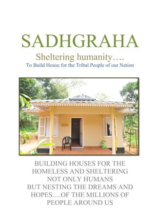
1. SADHGRAHA
Sheltering humanity….
To Build House for the Tribal People of our Nation
BUILDING HOUSES FOR THE
HOMELESS AND SHELTERING
NOT ONLY HUMANS
BUT NESTING THE DREAMS AND
HOPES….OF THE MILLIONS OF
PEOPLE AROUND US
2. PROJECT PROPOSAL ON
THE DEVELOPMENT OF
INDIVIDUAL HOUSES FOR
TRIBAL PEOPLE IN
VARIOUS STATES OF
INDIA
3. PROJECT PROPOSAL ON
THE DEVELOPMENT OF INDIVIDUAL HOUSES FOR
TRIBAL PEOPLE IN VARIOUS STATES OF INDIA
Submitted by
HRDS INDIA
( THE HIGHRANGE RURAL DEVELOPMENT SOCIETY )
Door No: XIV/273, Near Post Office, Chandranagar, Palakkad-District, Kerala, India
PIN - 678007.
4. Organization Profile
Project Title Project Proposal on the Development of
Individual Houses for Tribal People in
Various States of India.
Implementing Organisation HRDS INDIA (The Highrange Rural
Development Society)
Address for Correspondence HRDS INDIA, Door No: XIV/273,
Near Post Office, Chandranagar, Palakkad-
District, Kerala, India - 678007.
Legal Status of Implementing
Organisation
Registered under TCLS&CSR Act 1955
Registration act 1955, No: 1-170/97 Dated on
13/08/1997.
12AA of IT Act CIT/CHN/12A/Tech75/2001-02
Dated on: 14/01/2004.
80G (5) VI of 7/2010[F.NO.197/21/2010-ITA-I]
Dated on: 27/10/2010.
FCRA NO: 052940065 Dated on 15/05/2002
Name of Principal Investigator Liz Joseph Ann PGD in Structural
Engineering (Manchester, UK)
Project Director
HRDS INDIA
Chief Functionary AJI KRISHNAN,
Founder-Secretary, HRDS INDIA
Phone No: +919446488457
Target Area Various States of India
Target Group Tribal People
Project Duration 9 Years
Total Budget of the Project Rs.127224600000/-
Bank Details Yes Bank
RS Puram Branch, Coimbatore,
Tamilnadu, India.
Current Account-069288700000013
IFS Code: YESB0000692
Swift Code: YESBINBB
5. Abbreviations and Acronym
HRDS INDIA : The Highrange Rural Development Society
FGD : Focus Group Discussion
NGO : Non Governmental Organisation
CBO : Community Based Organisation
RCC : Reinforced Cement Concrete
IEC : Information Education and Communication
SHD : Self Help Group Discussions
Govt : Government
ITDP : Integrated Tribal Development Project
6. PROJECT PROPOSAL ON
THE DEVELOPMENT OF
INDIVIDUAL HOUSES FOR
TRIBAL PEOPLE IN
VARIOUS STATES OF
INDIA
FOREWORD
7. Dr. S. Krishnakumar IAS (Retd)
(Former Union Minister),
President
HRDS INDIA
(The Highrange Rural Development Society)
FOREWORD
HRDS INDIA (The Highrange Rural Development Society) is dedicated to the development and
up gradation of Tribes through various grassroots actions. We look forward to upgrade the living
status of Tribal Community in all aspects. Since poor and marginalized people lack the resources
needed to reduce the negative effects of the society which will hit the most vulnerable groups of
society the hardest. In this light, HRDS INDIA has compiled a proposal for “The Development
of Individual Houses for Tribal People in various States of India”. The project will have a two-
sided effect: it will improve the basic needs of Tribes in the proposed location and the same time
it will give a sense of security and protection.
Dr. S. Krishnakumar IAS (Retd)
(Former Union Minister),
President
HRDS INDIA (The Highrange Rural Development Society)
8. CHAPTER 1
PROFILE OF THE IMPLEMENTING ORGANISATION (HRDS INDIA)
1.1 Introduction:
HRDS INDIA (The Highrange Rural Development Society) is a non profit community based
organization working for the up gradation of Tribal community, women empowerment,
education and livelihood promotion. HRDS INDIA aspires to improve the living conditions of
the poor and marginalized people by adopting strategies
through community initiative, participation and sensitization. Founded in 1997, the organization
has worked among backward communities in the interior unreached pockets of Tribes in Kerala.
Women self help groups have been taken as the base for all interventions and livelihood
activities, enabling them to contribute towards the mainstream of the developmental activities.
1.2 Vision
HRDS INDIA envisions a society where Tribes have the guaranteed fundamental amenities like
houses, opportunities of development through education, health, livelihood and social security.
1.3 Mission
HRDS INDIA is dedicated to uplifting the status of the Tribal community through various
developmental initiatives.
1.4 Legal status:
Registered under : TCLS&CS Registration Act 1955
Registration No : 1-170/97 date 13/08/1997.
FCRA NO : 052940065/02
FCRA Account No. :10415743929 with State Bank of India, Kattappana Branch
Bank Account No. : Current Account - 069288700000013, Yes Bank
RS Puram Branch, Coimbatore, Tamilnadu, India.
12AA of IT Act No. : CIT/CHN/12A/Tech75/2001-02 Dated on: 14/01/2004.
80G (5) VI of IT Act No. : 7/2010[F.NO.197/21/2010-ITA-I] Dated on: 27/10/2010.
9. 1.5 Objectives
• To provide Houses for the Tribes those who are living in an extremely backward situation.
• To promote Community Based Organizations on the grassroots level of
sustainable development of Tribes.
• To provide livelihood promotion and social inclusion services to the poor and low
income clients in the rural and semi urban areas with innovative solutions.
• To promote value based education among children, women and youth for Holistic
Development.
• To provide capacity building to various stakeholders and undertake evidence
based research on various development themes.
• To work on various issues like HIV/AIDS prevention, Environment and Climate
change.
• To network with Government, NGOs, and CBOs for advocacy and policy level changes.
1.6 Strategy
• HRDS INDIA strives to improve the quality of life of the Rural poor, especially Tribes
by strengthening their existing livelihood programmes, initiate new activities to diversify
and increase their income.
• To develop community owned and managed institutions to sustain the livelihood
activities.
• To develop well trained and highly capable local service providers to provide timely
support to the members.
• To develop community based models for natural resource management in order to
protect and use the resources for sustainable development.
• To work in collaboration with the Government and the industry.
10. CHAPTER 2
BACKGROUND OF THE PROJECT
2.1 BACKGROUND
2.1.1 Introduction
HRDS INDIA introduces Fibre Panels which is a new strategy for constructing homes to
maintain environmental sustainability. Fibre Cement Panels are mainly cement bonded particle
boards and cement fibre. Cement bonded particle boards have treated wood flakes as
reinforcement, whereas in cement fibre boards have cellulose fibre, which is a plant extract as
reinforcement. Cement acts as binder in both the cases. The fire resistance properties of cement
bonded blue particle boards and cement fibre boards are the same. In terms of load-bearing
capacity, cement-bonded particle boards have higher capacity than cement fibre boards. Cement
particle boards can be manufactured from 6 mm to 40 mm thickness, making it ideally suitable
for high load bearing applications. These boards are made of a homogeneous mixture and hence
are formed as single layer for any thickness. Cement fibre boards are more used in decorative
applications and can be manufactured from 3 mm to 20 mm thickness. HRDS INDIA is
proposing to build houses by using the Fibre Cement Panels by considering the excellent quality
these materials as explained above.
2.1.2 Objectives
➢ The basic objective of the project is the Individual House Development for the Tribes
with a healthy and natural environment by providing adequate shelter and basic
infrastructure facilities in the various States of India.
The ultimate objective of the project is to:
• To take up construction of houses by using Fibre Cement Panels in scattered plots owned
by the individual Tribes (Those who have minimum 3 scent own plots) rather than going
for cluster approach.
• To provide basic services to the Tribal people who inhabit in unhealthy situations.
• To introduce a new concept for making homes by using an aero cone panel instead of
traditional style.
11. 2.1.3 Scope of work
• To review the present housing and infrastructure status of the Tribal areas in various
States of India.
• To assess the requirement of housing and infrastructure through a consultative process.
• To assess the living status of the Tribes to make available the deserved facilities.
• To reforms to be undertaken to upgrade their present status.
• To the requirements of capacity building to the public representatives or officials of the
project sites/local administration.
2.1.4 Approach and Methodology
Detailed socio-economic or environmental survey is most required to update the living status of
the people those who are residing in the proposed site. This detailed survey report will be
incorporated in the detailed report. The proposed project is targeted to provide houses for the
Tribes those who have at least 3 or 4 cents of own plots. Survey data will analyze more precisely
to make available the facilities to the deserved people in the targeted sites. Also, it will be
exactly proof to explain the environmental as well as the socio-economic status of the people
residing over there.
The detailed methodology given in Table 1 below:
Table 2.1: Methodology
Methodology Explanation
Categorization of
sites in various States
of India
Sites has to categorize as primary and secondary to fill up the
needs according to the preliminary field survey
Provider Assessment Role, responsibility, accountability mapping, governance
parameters.
Detailed Survey
(Socio Economic and
Environmental
concern)
Detailed survey on all aspects is most required to analyze the
existing situation.
Stakeholder Analysis Inventorization of stakeholders, identification of key stakeholders,
map perceptions, concerns, incentives and disincentives.
Stakeholder
Workshops Conduct stakeholder workshops to validate the draft/final reports.
12. IEC Training programmes to be conducted for the upgradation of
Tribes before and after finalizing the proposed projects. Also
requires research studies in the site to avoid impacts during project
implementation or further developmental activities. Also these
kind studies can provide suitable mitigation measures to tackle the
issues while implementing the project.
Initiative for
implementing the
project in the selected
locations
Development of individual houses in the specified locations.
2.2 PRELIMINARY STAGE
2.2.1 Key Informants Interview
A number of Key Informants like Elected representatives, Officials and Subject Experts will be
interviewed to establish the necessity of the proposed project.
2.2.2 Site Studies
The present situation of the proposed site has to be done elaborately based on the preliminary
surveys or studies. It will give a vague picture about the proposed site.
2.2.3 Expert Visit includes field study
The team of experts will visit selected sites, attend a meeting with the concerned officials, meet
different stakeholders, conduct field visits to have 1st hand information regarding the project.
Additionally, the team assesses the willingness of the citizens either directly or through elected
members which can be done through Stakeholder Analysis, Technology Assessment, Investment
requirement Assessment, Analysis of Regulatory Framework, Institutional Analysis
Environmental Impact, Sustainability Evaluation etc.
2.2.4 Stakeholder Consultation Workshop
A Stakeholder Consultation Workshop will be conducted involving officials, NGOs, experts,
regulators, and related institutions. The feedback of study team regarding the status and
compliance and what they captured from the key informant interview will be presented in the
workshop, followed by detailed consultations.
2.2.5 Secondary Data Collection and Desk Review
Secondary data will be collected from different related institutions and various websites will be
reviewed.
13. 2.3 SECONDARY STAGE
2.3.1 Constitution of Survey Team
A team of researchers will be constituted for the primary survey, including environmental
experts and social assessment experts. The team will be trained thoroughly before the survey
commenced.
2.3.2 Categorization of Sites in various States Based on Survey Report
Based on the primary analysis the cities/areas have to be categorized into different types. This
classification can be given based on the people those who are living in the house types as 1)
Pucca with RCC roof, 2) Pucca with CGI roof, 3) Semi Pucca and 4) Kutcha. This classification
will help to make available the project benefits to the most deserved one in priority basis.
2.3.3 Stake Holder Discussions (SHD) /Focus Group Discussions (FGD)
In order to capture qualitative information FGDs of concern staff, elected representatives,
Institutions or NGOs those who are working for the upgradation of Tribes. SHD/FGD will be
conducted in selected locations in each District as part of the provider assessment. Important
points generating in these discussions will be useful for finalizing the detailed project report.
2.3.4 Information Education and Communication (IEC)
Training programs are an unavoidable part of the project and which has to be done by the
experienced trainers to upgrade the Tribal People. These training programs have to be conducted
frequently before and after implementation of the proposed project to make them aware about
the consequences and to utilize the benefits of the project.
2.3.5 Approval of the final document
The final report has to validate by the authority concerned.
2.3.6 Implementation of the Project in Field
HRDS India will organize a project implementation unit with experienced professionals and
field staffs to implement the project successfully. Well organized action plan will be formed to
do the work accordingly.
2.4 NEW CONCEPT FOR IMPLEMENTING HOUSING PROJECT
2.4.1 Introduction about Fibre Cement Boards
HRDS INDIA is introducing Fiber Cement Panels which is an innovation in building material
for individual houses in the proposed project site. Fibre Cement Panels are certified green
products which are helping to conserve the environment in many aspects. Fibre Cement Board is
composed of a composite matrix containing special grade cellulose fibres, ordinary Portland
cement, fine silica, quartz, and some mineral additives.
2.4.2 FibreCement Panels - Certified Green Product
Fibre Cement Panels are strong, durable and efficient. Fibre cement boards are highly resistant
to moisture, fire and termite and used for commercial, industrial or residential purposes. Cement
Boards are a strong choice for dry wall constructions, installation, replacing, removal, quick and
14. easy. These boards can be finished with paints and they are asbestos free and perform well in
high moisture and wet areas.
Also attaching the green certificate copy and some photos;
2.4.3 Composition
Fibre Cement Panels are mainly Cement Bonded particle boards and cement fibre. Cement
bonded particle boards have treated wood flakes as reinforcement, whereas in cement fibre
boards have cellulose fibre, which is a plant extract as reinforcement. Cement acts as binder in
both the cases. The fire resistance properties of cement bonded blue particle boards and cement
fibre boards are the same. In terms of load-bearing capacity, cement-bonded particle boards have
higher capacity than cement fibre boards. Cement particle boards can be manufactured from
6 mm to 40 mm thickness, making it ideally suitable for high load bearing applications. These
boards are made of a homogeneous mixture and hence are formed as a single layer for any
thickness. Cement Fibre Boards are more used in decorative applications and can be
manufactured from 3 mm to 20 mm thickness. Many manufacturers use additives like mica,
aluminium sitrate and cenospheres in order to achieve certain board qualities. The typical
cement fibre board is made of approximately 40-60% of cement, 20-30% of fillers, 8-10% of
cellulose, 10-15% of mica. Other additives like above mentioned aluminium stearate and PVA
are normally used in quantities less than 1%. Cenospheres are used only in low density boards
with quantities between 10-15%. The actual recipe depends on available raw materials and other
local factors.
2.4.4 Advantages
As a tile backing board, fibre cement panels have better long-term performance than paper-faced
gypsum core products because it will not mildew or physically break down in the continued
presence of moisture or leaks. Fibre Cement Panel is not actually waterproof, but it is highly
15. resistant to absorbing moisture and has excellent drying properties. In areas continually exposed
to water spray (i.e. showers) a waterproofing barrier is usually recommended behind the boards
or as a trowel-applied product to the face of the boards behind the finish system.
2.4.5 Disadvantages
One major disadvantage of cement board is the weight per square foot. It is approximately twice
that of gypsum board, making handling by one person difficult. Cutting of cement board must
also be done with carbide-tipped tools and saw blades. Due to its hardness, pre-drilling of
fasteners is often recommended. Finally, cement board is initially more expensive than water
resistant gypsum board, but may provide better long term value.
2.4.6 Installation
Fibre Cement Panel is hung with corrosion resistant screws or ring-shank nails. Cement board
has very little movement under thermal stress, but the boards are usually installed with a slight
gap at the joints in shower pans, bathtubs, and each other. These joints are then filled with
silicone sealant or the manufacturer's taping compounds before applying a finish. The filled
joints are taped like a conventional gypsum board, but with fibreglass tapes that provide
additional water resistance. Combined with a water impermeable finish, cement board is a
stable, durable backing board.
2.4.7 Water resistance
The category of construction material known as fibre cement board includes both water resistant
and waterproof board. Each has its own best use. Typically, water resistant cement board is
composed of a treated gypsum core with a non organic fibre reinforced covering, either on one
or both faces. This type of board requires fastidious sealing of all cut edges and penetrations to
maintain the manufacturer's warranty for wet area installations. Gypsum core "cement" board
panels are ideal for moist but not truly wet installations of tile and/or stone walls.
There is a class of cement board strictly constructed of a Portland cement based core with glass
fibre mat reinforcing at both faces. This type board is truly waterproof. These panels can be
immersed in water without any degradation (excluding freeze thaw cycles). These panels do not
require the sealing of edges and penetrations to maintain their structural integrity These Portland
cement based products are smaller in size compared with the gypsum core based products.
Typically they range in size from 30" x 48" to 36" x 60". They are, as one would expect,
considerably heavier than the gypsum core type panels. Portland cement based panels are ideal
for truly wet locations like shower surrounds and for locations where a Portland cement based
16. thin-set material is used for bonding tile and stone surfaces to a substrate. They are also ideal for
floor tile and stone installations over a structural subfloor.
Cement boards may be classified as water resistant as in not affected by water exposure;
however, they do allow penetration and passage of water and water vapour. To waterproof
cement boards, a liquid or membrane waterproofing material is applied over its surface.
2.4.8 Energy Conservation and Eco-friendly
Fibre Cement Panels are assuring energy conservation, which is the most required aspect for
sustainable development. Fibre Cement Panels are one of the major contributions to the society
to reduce global warming. Since it is prefabricated panels, house construction will finish soon. It
can have adaptable designs for varying climatic conditions. They have 1/3rd
wait of clay bricks.
These are ideal for high rise buildings. Thus, it will save money, which has to be spent for
cement and steel. Fibre Cement Boards have perfect finished structures, alignment, smooth
walls, etc. They have perfect sound and thermal insulation capacity. They are microbes and
germs free, high thermal insulators, high light reflectance and eco-friendly made with recycled
materials.
Fibre Cement Panels
23. Budget for the Proposed House.
Uneven ground levelling, excavation for footings and block work, compaction with machinery,
50mm pcc below block work and footing, Rcc works for footing and above solid block, solid
block work (size 400mm x 200mm x200mm), backfilling and compaction, curing etc.
(Drawing attached for ref.) Rs 48475.00
1. Cement fibre Board for wall 9 ft x 4 ft x 18mm Total no.
of board 25 Nos Say25 nos@2166/Board
(Fibre Cement Board is composed of a composite matrix
containing special grade cellulose fibres, ordinary Portland
cement, fine silica, quartz, and some mineral additives.) Rs.54,150.00
2. Channel (HR Section) 2 (PC) 12GU x 20 x 40mm (575 Kg)
Say 575 kg@ 74 /kg Rs. 42550.00
3. Supplying and fixing steel door frames with wooden shutters
Say 4 No’s @6000/E Rs. 24000.00
4. Supplying and fixing steel window frames with wooden shutters
Say 5Nos@5500/E Rs.27,500.00
5. Roofing with GI Roofing sheet 0.45GU, including frame work
Say 48m2@1300/m2 Rs. 62400.00
6. Flooring with 1 : 5 : 10 PCC
Say 28m2@985/m2 Rs.27,580.00
7. Floor tiles (size ceramic 9 x 9)
Say 370 @75/ sq.ft Rs.27750.00
8. Furniture (details attached) Rs.28,000.00
9. White washing , Painting, etc. Rs.15,000.00
10. Toilet, Tank. Waste water tank Rs.10,000.00
(size 5 feet x 4 feet dia)(2 feet x 2 feet dia)
11. Door and window fittings Rs. 2,500.00
12. Board fixing and channel Rs. 14875.00
13. Supplying and providing solar light Rs. 5,000.00
14. Planting trees Rs. 800.00
15. Toilet door Rs. 2000.00
TOTAL RS.3,92,580/-
24. 2.5 Relevance of the project to the work already going on in the Organization
HRDS INDIA has already completed a number of studies and projects in the area. The Unit has
completed a number of projects sponsored by various National and Local agencies. At present
the Unit has been engaged in various housing projects as well as dedicated works to upgrade the
living status of Tribes in many locations in India. Apart from this, the centre has recently done
Tribal upgradation projects for strengthening the present system. The centre has the necessary
facilities and expertise to carry out studies on various development sectors.
26. CHAPTER 3
NEED OF THE PROJECT
3.1. BACKGROUND OF THE PROJECT AREA
Tribal population is very high in various States of our Country. Most of the Tribes are situating
in very poor living conditions. More than half of the Tribal population resides in six states:
Madhya Pradesh, Chhattisgarh, Maharashtra, Orissa, Jharkhand and Gujarat. The Northeast of
India has a particularly heavy Tribal element. These ancient aboriginal peoples tend to live in
isolated communities in hills and forestlands, far from urban centers. There are 4614 landless
Tribal families in the State of Kerala. In this circumstance of Kerala more than 55 percent live in
dilapidated houses. In all, 39,850 houses do not have kitchen and 49 percent does not have
toilets. Half of the population deprived of pure drinking water and 1252 Tribal hamlets are not
electrified. More than 1300 Tribal settlements face threat from wild animals. Many of the
families do not have any access to medical care. Among them, 4,036 are differently disabled and
2386 are mentally-challenged. The community has 40,323 chronic patients. The literacy rate
among the scheduled Tribes is 72.77.
Most of them used to drop out of schools at the primary level itself. Poverty and lack of access to
educational institutions are the major reasons. The dress pattern of the Tribes is Kerang Saree
reaching half way of the knee, great rings on their neck, rings on their fingers, brass bell on their
toes, heavy brass bangles on hand and various necklaces in their neck. Tribes used to build a
shed for domestic animals outside their residence with homogeneous pattern. The walls are made
of mud or stone with a number of pillars supporting the roof, which is thatched with forest grass
or paddy straws. Typically, most of the houses don’t have windows. In some places the houses
built with loosely layered stone walls for the boundary and plastic sheets as roof. The soil of the
project sites is mostly red, mixed red, alluvial, red and black. Texture in most of the locations is
sandy and clay loam. PH level is most suitable for cultivation and its fertility status is very high.
3. 2. SITUATION ANALYSIS
The project area is backward in all aspects, mostly inhabited by Tribal indigenous groups. Most
of them are living under below the poverty line. More than 95% of the Tribes depended on forest
and agricultural products, daily labourers and allied activities. Animal husbandry is one of the
sources of livelihood for these people. Health status of the people is very poor. Children’s death
rate is very high due to malnutrition, severe anaemia apart from this; most of the delivery is
carried out at home by untrained persons. The system of education is not up to the mark in these
areas. This depends on many factors like unorganised education system, inadequate
infrastructure, irregularity of teachers in the classrooms, non-involvement of the parents etc.
Ultimately it
27. leads the younger generation to the utter frustration and disappointment as a result, they take the
shelter of alcoholism and other bad habits. Although people are politically aware of, but they are
still under the clutches of village touts who mislead and misguide the target community. The
elected members try to keep people in the darkness without informing them about various
government schemes, plans, and programmes available for them. Though the community has a
rich cultural background, it is degraded, looked down and discouraged by the upper caste people.
It is really in a deplorable situation. The status of the women in the community is very low.
About 80% of the women are unskilled and agricultural labourers. They are illiterate,
unorganized and unhealthy. The women torture is more in the society. The women are
discriminated in getting wages. They are treated as second citizens. Their manpower and
potentials are not given due importance. The marketing system is fully controlled by the
middlemen. Because of the poor marketing system exploitive nature middle men, lack of pro-
poor policy, lack of communication and above all the people have no bargaining power; they got
no profit for the crops which are produced by the Tribes. The land holding pattern of the
community ranges from 3 to 5 acres. The yielding capacity is very low because of the lack of
awareness in modern technology in agriculture. There are various factors influencing directly
and indirectly for the development process of Tribes in various States of India.
3.3 POLITICAL FACTORS
The government has launched numerous developmental activities to alleviate and eradicate
poverty, illiteracy and health hazard from the rural area, these programmes have not in any way
changed and affected the present situation of the people of this area. The majority of the people
is not getting a single meal per day, cannot get treatment when they are sick. It is all due to the
inertia and all kinds of corruption by the governance system. People are dominated and exploited
by the politicians because of the lack of awareness about the political system. Most of the
political parties are getting benefits by utilizing the simplicity of the Tribes.
3.4 ECONOMIC FACTORS
The people of this area, though eligible for greater assistance in terms of development
programmers remain exploited and deprived of their basic human rights like food, shelter,
education, medicine, etc. Agriculture, physical labour and collection of minor forest products are
the main sources of their income. The land suffers from low productivity due to traditional
methods of cultivation and lack of irrigation facilities. The land needs reclamation measures
since it is covered with big trees and bushes. Since hills and forests surround it, proper
precautions have to be taken even if they are cultivating anything in their land area. The per
capita income of the people is very low. The low yield causes object poverty and starvation even
for farmer holding land up to 3-5 acres. The marginal, landless and agricultural labourers are
paid meagre wages of Rs. 50/-or Rs 60 because of the ignorance, illiteracy and lack of skills.
This compels them to substitute their income forest products. However, due to the rigid
28. restriction of the Government against exploitation of forests, their life has become more difficult.
Most of the houses made up of mud; wood thatched with straw, hemp and other forest leaves.
Thus, people are living in terrible socio- economic condition.
3.5 SOCIAL FACTORS
Illiteracy, ignorance, insufficient awareness and lack of organized effort appear to be the root
cause of the major problems of socio-economic, educational, health and backwardness of these
people. The female literacy rate is very hopeless. govt. has provision to look after to the
educational aspect of the people by establishing schools and collages, but it is not implemented
and functioning well. According to the govt. role and system in each village, the establishment
of primary schools is necessary. Already existing schools suffer from poor infrastructure and
absence of teachers. Even if the villagers complain this matter to the authority, but their efforts
turn up into a fiasco. This kind of recharged problem is contained in the educational department.
This scenario presently exists in the area. People are thus greatly frustrated and variously
deprived of educational facilities. The area is inaccessible and isolated from the main road. Due
to financial problem many do not go to hospital, they are treated in the village by the quacks or
herbal medicines, which is not sure of healing. Many children suffer from malnutrition, polio,
and chronic diseases. Vaccination is very rare. As a result, infant and maternal mortality rate is
high. There are govt. health workers, but they are unable to visit these villages due to forest,
distance, no communication facilities. Malaria is the very common and dangerous fever in this
area. Many people die of malaria. During the raining season, it is extremely difficult for the
people to come down to the hospital. It is noted that most of the people depend upon stream and
rivulets for drinking water. The govt. health worker rarely visits these villages. Thus, health and
sanitation is much neglected. The major diseases are related to protein and caloric deficiency and
contamination of water viz. Anemia, scabies, diarrhea; deice try, polio, small fox and
tuberculosis.
In this remote, interior area, there are no bus services, electricity and Telephone services too.
There are no proper road facilities. Since there is no marketing facility, nearby, they are
compelled to sell the goods at low prices. The villages are not connected with metal roads only
footpath or muddy roads and villages are not supplied with electricity for generation people are
living in the same situation. Ignorance of the people, negligence of Government authorities and
interference of middlemen are causing the miserable life of the people.
3.6 ECOLOGICAL FACTORS
The area, fully occupied with a green environments and people believing forests theory goddess.
Along with purified water from rivers and hill areas also available to produce organic method of
cultivation of paddy and other vegetables. They are depending upon the forest products. The
Tribal People directly and indirectly protecting their ecological system as well as the green
environment.
29. 3.7 TECHNICAL FACTORS
Here the Tribal People are not using any technology in agriculture and other non form
cultivation. They are unable to access any technology intervention. They are practicing a
traditional style in their day to day livelihood and food security.
3.8 LEGAL FACTORS
In this area, a few registered NGOs are working in various educational, health and other
livelihood sectors. At community level, any registered cooperatives and other community based
organizations not available for sustainable development of the people.
3.9 PROBLEM IDENTIFICATION
The committee staff members of the organization identified various problems in association with
community based organization by using various participatory tools, survey mentioned below:
90% of the people are homeless.
80% of the people are under below the poverty line.
98% of them belong to Tribal (Adivasi) communities.
The area is located in the Hilly track with a high density of the forest.
Livelihood insecurity and alternative livelihood opportunities
Majority of Tribal is a landless and daily labourer.
More than 80 percent of the population lives below the poverty line.
Low levels of literacy in Tribal communities.
Proposed project aimed to improve the living conditions of the poor by directly involving the
appropriate target groups. Still livelihood is the major problem for Tribal.
30. CHAPTER 4
TRIBES AND THEIR HABITAT INCLUDES GEOLOGICAL AND PHYSICAL
CHARACTERISTICS OF THE SAMPLE PROJECT LOCATION
(WAYANAD AND PALAKKAD)
4.1 INTRODUCTION
The HRDS INDIA (The Highrange Rural Development Society) sample project site is located in
Wayanad and Palakkad Districts of Kerala. The sample project successfully works in progress to
these locations. And also we try to implement the project in other States of India. In this chapter,
have explained our completed project location details in Wayanad, and Palakkad. Both these
areas were chosen for various reasons. Uncontrolled deforestation, over-grazing, inappropriate
methods of agricultural practice, etc., have all contributed to the indiscriminate removal of dense
forest cover of this area since the second quarter of this century. Unplanned human settlement in
a forested area has made a red desert in the proposed site. Apart from this, the variety of
agricultural practices (shifting cultivation to modern farming) have made a lot of difficulties in
the area. Deforestation and unsuitable agricultural practices have left scars both on the land and
the people. Rains evade the area, rivers run dry most part of the year, the fertility of the soil is
lost, and thus, agricultural production, the mainstay of the majority of the population is
jeopardized. Deforestation as a consequence of inappropriate forest management and unhealthy
human interactions has produced a semi-desert within a few kilometers of the lush evergreen
forests of Muthikulam and Silent Valley ranges. The region is included in the echoes zone of the
Nilgiri Biosphere Reserve and represents an absolute microcosm of forest splendor. The
situation leads to large scale erosion and low productivity in the occupied land of this area.
Considering all these things, the Government took the decision to provide scientifically well
planned human settlement for the people those who are in trouble.
There are forty eight Tribal Communities throughout the State; out of which thirty eight was
Scheduled Tribes and the rest are identified Tribal Communities. Among the Tribal
Communities in Kerala, the most numerically dominant are Paniyas, Maratis, Malayarayans,
Kuravans, Kurichians and Erulas. The Tribal Communities of Kerala don’t only differ from the
non-Tribal but also from one another. But they have some uniform characteristics. An attempt to
classify the Tribes of Kerala on the basis of their economy reveals that they are food gatherers,
hunters, shifting cultivators, farm labourers and agriculturists. The general name for Tribes in
Travancore-Cochin area is 'Kattujathi' and in Malabar 'Kattukuruman'. Both these names mean
people of the forest. According to the 1991 Census, the population of the Kanikkaran constituted
11,876 and the Muthuvan of Travancore and Mudugas of Attappady together numbered 7,932.
31. The Adiyas constituted 7,073. The population of Kattunayakan, Mannan, Velladen and Malayan
ranged between 3,000 and 5,000 each, while the Tribes like Oorali, Hill Pulayas and Malai
Arayan numbered between 2,000 and 3,000. The Cholanaikan found in the Nilambur forests of
Malappuram District, is the most primitive Tribal community of Kerala. They live in caves.
Every District in Kerala has some Tribal population. They are found significantly in the Districts
of Wayanad, Kannur, Kozhikode, Palakkad and Idukki. These Districts are having 80% of the
Tribal population in Kerala. However, the main Tribal Communities are in the Taluks with
North Wayanad, South Wayanad, Mannerghat, Devikulam and Thodupuzha.
The Tribes have their own special lifestyles, culture, customs, traditions and religious practices.
They do not have a written script. Their history can be traced only through their oral tradition
and religious practices. As a result of the changes taking place, even their practices are becoming
extinct. Now-a-days many Tribal people blindly follow the modern culture. As a result, they are
losing their unique culture, land, language, etc. They have become a minority community
exploited by others.
Tribal hamlets of Attappady are found in all the three Panchayaths, namely, Agali, Pudhur, and
Sholayoor. lrula hamlets dominate in all the three Panchayaths. Kurumbas reside only in Pudhur
and Sholayoor is an exclusively zilla Panchayath. Numerically, lrulas from the largest Tribal
community (82.25%) followed by Mudugas (l2.53%), and Kurumbas (5.22%). The annual
compound growth rate of Kurumbas during the period 1961 to 1981 was 2.44% as against 1.61%
in the case of Mudugas, and 2.41% in the case of lrulas.
4.1.1 Tribes in Attappady
Irulas: The Irulas (Imlans or lrulars), the numerically dominant Tribe of Attappady, derive their
name from their pitch-black complexion. Irulars are of Tamil origin and formerly inhabitants of
Coimbatore District. It is probable that the people in Attappady are the descendants of persons
who had migrated from Coimbatore during a period when Coimbatore and neighbouring places
to experience severe water scarcity. The history of their mass immigration to Attappady dates
back to the end of the 16th century or the beginning of the 17th century. There are at present 104
lrula hamlets in Attappady. Irulas are of medium height, long armed and have curly hair,
prominent cheekbones and narrow noses. They speak a mixture of Malayalam, Kannada and
Tamil.
Originally they practiced shifting cultivation. As a consequence of the widespread encroachment
of Attappady by mainland settlers Irulas have taken to settle-agriculture and plough cultivation.
They used to cultivate millets such as makkacholam, ragi or French millet and chana, pulses
(like thuvara or red gram) and oilseeds (like groundnut and castor seed). As of now, they have
added to their cropping pattern almost all the crops cultivated by Tamil and Malayali settlers.
The traditional Irula houses are made up of bamboo, mud, and grass and are built in a row in
close proximity to one another. In recent years, the Integrated Tribal Development Project
32. (ITDP) in certain lrula hamlets constructed a number of tiled and concrete houses. Irulas fight
for these Government-sponsored houses in spite of the fact that they’re sleeping under these
asbestos or tile roofed houses is for them like lying below amber bead. As sleeping within the
house is intolerable during summer, Irulas in hamlet sleep at night outside these concrete or
asbestos or tile roof.
Mudugas: Mudugas are the second largest Tribal community in Attappady. It is believed that
the Mudugas were the original inhabitants of Coimbatore and later moved westward due to
persecution and exploitation by more dominant communities. The name Mudugas is said to have
originated from the primitive custom of carrying children on their Muthuku (back) which is not
the practice of other Tribes in the valley. Mudugas live in remote forest settlements of the
Attappady Tribal area. They always prefer to remain as far removed as possible from the
‘civilized’ people from the plain. Mudugas have no knowledge about their origin and early
history, though they are believed to be Tamilians from Coimbatore District, who are lured by the
possibility of agricultural activities in the fertile soils of Attappady. They have legends
connected with their origin in common with those of the Kurumbas. There is a belief that they
had once been Kurumbas and that they broke away from that Tribal group to form a separate
community. Their principal agricultural products are Chama, ragi, rice, red gram, black gram,
horse gram, cotton, groundnut, ginger, sweet potato, and tapioca. Mudugas lost most of their
land by downright encroachment or other devious mechanization by Malayali settlers. The
growing contact between Mudugas and Malayali settlers has led to acculturation of these Tribes,
which often ends up in marital alliances with the latter and erosion of Tribal practices and
culture.
Kurumbas: The Kurumbas are considered to be the earliest Tribal inhabitants of Attappady.
When the Badagas started colonizing the Nilgiris, these people moved down to Attappady
valley. They are the smallest among the three Tribal groups of Attappady. Kurumbas also claim
that they are the descendants of people who had fled from Mysore during a period of war and
hid in the forests. Most of the Kurumba families are residing in the reserved forests and in the
vested forests located which is the valley of river Bhavani and its tributary. Kurumbas are short,
snub nosed people. However, all these people have their settlements inside the forest, and until
recently they had hardly any contact with the outside world, not even with the Irulas and
Mudugas. The language spoken by them is a mixture of Kannada, Malayalam and Tamil. They
maintain a community life by sharing labour and food with others in the hamlet as and when
required. Moopan is the man who decides about the common issues affecting the hamlet. He is
the connecting link between the outside world and the families, especially between the
Government and Tribal community. Their houses are built, in general, in rows, with grass,
bamboo and mud.
33. 4.1.2 Tribes in Wayanad
Mullakurumar: Mullakurumars are considered as the followers of the royal family of Vedar.
Mullakurumar believe in god Shiva. There are four sections among them. They consider
marriage from their own particular section as taboo. Mullakurumar have a feeling that they are
superior to other Tribal Groups. They speak a mixed language of Tamil and Malayalam. Their
language does not have scripts. They live in Wayanad and Gudallur Taluks in Tamil Nadu.
Mullakurumar have better education than others and some of them have Government jobs as
well. They have some land of their own. They are experts in hunting.
Uralikurumar: Uralikurumars have special skills to make items from bamboo and cane.
Uralikurumars also make items of iron, like a sword, knife, arrow guns, etc. They speak a
mixture of Kannada, Malayalam, Tamil and Tulu. This Tribal Group to do not have a script.
They are found in southern Wayanad and Vythiri Taluk. They are very backward in education.
Kattunaikan: Kattunaikans are also known as Thenkurumer and they are experts in collecting
honey and prefer to live in the forest. Kattunaikan speak a Dravidian language mixed with
Kannada. Their language also has no scripts. They have no education and do not possess any
land. They are found in Wayanad, Nilgiris and Karnataka.
Paniyas: Paniyas outnumber the other Tribal found in Wayanad. They have some similarity to
the Negroes. These sections of people are seen in Nilgiris, Wayanad, Kozhikode, Kannur,
Kudagu areas. Paniyas speak primitive Malayalam without any script. Most of them were slaves
of the non-Tribal landlords in the early periods. The majority of them do not have education and
land. At the present majority of Paniyas are causal agricultural labourers.
Adiyas: Adiyas live in Wayanad and Kudugu. They are divided into many clans and speak a
mixture of Kannada and Malayalam. There is no script for their language. Adiyas too, do not
have the education or land. The majority of them are agricultural work.
Kurichiyar: Kurichiyar were actively involved in the wars. They are found in Southern and
Northern Wayanad and in Kannur District. Like Mullakurumer, they too consider themselves as
superior to other Tribal groups.
Apart from the above mentioned groups there are also smaller groups like Kadar, Kalanadi,
Karimpalan, Kunduvadiyar, Thechanandom, Pathiyar and Mada.
34. 4.2 PHYSICAL AND GEOLOGICAL CHARACTERISTICS OF ATTAPPADY
4.2.1 Project Location
Fig. 4: Project Location Attapady
Attappady is an extensive mountain valley, located between l0055’l0’ and ll0l4’19’ North
latitude and between 76027’ll’ and 76048’8’ East longitude, stretching from Mukkaly to
Anakkatty and Thazemully to Muthikkulam covering an area of 745 sq.km in Mannarkad Taluk
of Palakkad District, Kerala State, South India. Attappady is essentially a plateau rising from the
undulating midlands beyond the east of Mannarkad Taluk to a height of 750-1000 metres. This
area is flanked by mountain ranges, the Nilgiris in the north, and extensions of the Western
Ghats in the south and the east.
4.2.2 Geology and soil
Attappady lies in the Attappady-Mettupalayam shear zone. The rocks are of pre-Cambrian
origin. The rocks belong to Hornblende, Gneiss, Biotite gneiss, Quartz feldspar, Biotite schist
and Charnokite. There are veins of pegmatite and Quartz introduced into various rock types.
There are nine soil associations identified in the Attappady area. They are (1) Arali-Bhavani (2)
Chittoor-Attayampathy (3) Gilsi'7’ Thekkuppana, (4) Mamana-Thavalam, (5) Rock outcrops-
vattakkallumala, (6) Rock-out crops-elathodu, (7) Thekurissi-Ponnani, (8) Vattakkallumala-
Sethumada, (9) Vattakkallumala-Rock-out-crops.
35. 4.2.3 Climate
Attappady region falls in the “High Altitude Zone”. The altitude varies from 750 to 1000 MSL.
Attappady range enjoys a cool, humid climate during rainy season. The slope facing west
receives rainfall of about 3000 mm annually, whereas area closer to the Tamil Nadu boundary,
that is, beyond Mukkali receives only 1000 mm annually. The rain shadow effect in the eastern
side is due to the high and steep hills in the Western region. Deforestation has brought about
dramatic changes in the Attappady ecosystem affecting cultivation. Here the changes in seasonal
variations show that South-west monsoon is received by people in Attappady between June-
September. The months from October-November are the season for North-East monsoon. Winter
occurs during the months December to February and the hot weather is between March to May.
4.2.4 Rivers
The main rivers in Attappady are Bhavani, Siruvani, Varagar, Kodangarapallam, Kunthipuzha.
Siruvani, Varagar and Kodangarappallam are the tributaries of river Bhavani. Attappady lies to
the east of the main Western Ghats watershed line and drains to the east to the river Cauvery
through Bhavani and her tributaries, Siruvani and Kodungarapallam. River Kundha joins
Bhavani in Tamilnadu at a place called Athikadavu. Attappady is essentially a plateau at an
approximate elevation of 500m above sea level, which is dissected by Bhavani, Siruvani and
Kodungarapallam into a series of valleys.
River Bhavani originates in the southwest corner of the Nilgiris in the Kundha hills of
Tamilnadu and after flowing for a few kilometres southward it enters Kerala through a deep
gorge and continues to south for another 20 km, between two high forested ridges till Mukkali.
At Mukkali, Bhavani takes an abrupt 120° turn towards the northeast and flows for another 25
km to Attappady in Kerala till it reaches Koodapetti in the Kerala-Tamilnadu border. The initial
course of the river steeply descending; thereafter it flows gently without descending much till it
exits from the State. At the Koodapetti, Siruvani and Kodungarapallam, flowing from the south
and south east respectively, join Bhavani. The Kundha River comes from north, draining an
extensive extent of the Nilgiris form the boundary between Kerala and Tamilnadu for 5 km
along the north eastern side of the Attappady. It then joins Bhavani on its left flank in
Tamilnadu. Thereafter Bhavani flows east along the base of Nilgiris. Siruvani, originating in the
southwestern corner of the Attappady plateau in the high rain drenched and heavily forested
Muthikulam hills, descends rapidly to the Attappady plateau and flows north-east tangentially
across Attappady towards its confluence with Kodungarapallam. During its 35 km course
through Attappady it receives a number of tributaries of which 5 important ones are from the
Varadimala slopes joining it on the right flank. There is only one important tributary joining it
on the left flank and it comes from the north-western slopes of the Muthikulam hills.
36. Kodungarapallam, from near its origin in the Penlmalmudi in the southeast corner of the
Attappady, flows north along the inter-State boundary for its entire length of 35 km. It joins
Siruvani and together they empty into Bhavani at Koodapetty.
4.2.5 Land use pattern
One of the most important assets, which determine the livelihood of inhabitants in an agrarian
society, island. Land degradation results in shifts or diversification in livelihood options. The
land use pattern in Attappady has undergone spectacular changes since the first quarter of the
past century degrading 74 the quality of its land to irreversibly unsustainable levels. The
dominant features of the most fragile mountain regions in developing countries are visible in the
Attappady mountain ranges also. Persistent negative changes are taking place in crop yields, in
the economic well-being of the people and in the environment and natural resources (Blaikie and
Brookfield, 1987). For instance, in Attappady compared to the situation five decades back, the
extent and severity of landslides is higher, water flow in rivers and streamlets is lower, yields of
major crops are lower, forest produce has dwindled as forest area sharply declined, over-grazing
converted many parts into deserts, and finally the extent of poverty and unemployment and out-
migration of persons who have little resources left with them has increased.
Fall in productivity and decline in the resilience of the traditional farming systems has led
Tribe’s folk to increasing dependence on the Government for assistance. The dangers, in most
cases, are irreversible or reversible only over a long period. The negative changes plainly visible
in the area relate to (l) land degradation affecting the resource base, (2) persistent decline in crop
yield, which affect the livelihood of the inhabitants and (3) increased unfeasibility of a specific
cropping pattern as a result of which resource management has become a tedious task. Table 3.3
provides the details about the land division in Attappady.
About 1129.14 ha of land is used for the purposes other than agriculture, 4957 ha is uncultivated
and other cattle grazing land, 500 ha is a permanent land with other cattle grazing land, 1100 ha
is with other tree cultivating area, 298 ha is with cultivable waste land, an area of 539 ha are
divided for area sowing more than once and the total cropping area is 8253.14 ha. The total
number of households in Attappady is 16,724. The operational land holdings are 11,405 in
numbers, of which 6,685 are below one hectare and 2,715 are between one and two hectares.
The Tribal communities live rather close to each other in 189 hamlets whereas the inhabitation
of the settlers is much more dispersed. One third of the total population is associated with
agricultural activities and there are 11,003 agricultural labourers.
4.2.6 Forest
The 444 sq.km of forestland in Attappady, which falls under the administrative jurisdiction of
the Mannarkkad Forest Division, holds four different forest types - West coast tropical forests,
Southern tropical dry deciduous Forests, Southern mountain wet temperate Forests and Southern
euphorbia Scrub. While some of these forest types are intact in Western Attappady, the forest
37. types and species in the eastern region have become shattered due to biotic interferences such as
uncontrolled illicit cuttings of trees and open grazing over the years. On account of such
widespread deterioration of the forests, the Attappady tract has been included in the restoration
zone of the Nilagiri Biosphere Reserve.
The thick forests in the Western region greet a person who enters Attappady from Mannarkkad.
But as one moves from West to East towards Anakkatty, the village bordering Tamilnadu,
gradually thinning of vegetation becomes more and more visible. In general, the hillocks on the
eastern side of Attappady have all become open with isolated trees standing covered with
vegetation, although the type of vegetation is distinctively like that of drier land. The stretches of
forests vary in density and composition. The forest was the Tribe’s folk’s home and not just their
house. It was their religion, culture, values, lifestyle, ethos, special norms, knowledge and
associated science, technology, and skills. The Tribe’s folk were integral to the forest eco-
system. But the British created havoc on their livelihood 78 by passing a law in 1865 vesting
forest under Government control. With this legislation the Tribe’s folk, the original owner of
forest, became trespassers in their own home, the forest, and began to be victimized by
externally motivated systems of forest management that directly violated various facets of their
economic and cultural survival.
4.2.7 Agriculture
Agriculture was the main source of livelihood for most of the people in Attappady. With the
large-scale influx of settlers the Tribal’s dependence on forest began to disappear tremendously.
Agriculture used to be supplemented by collection of forest produce and hunting. However the
share of forest produce and hunting as the source of livelihood started dwindling due to massive
destruction of the forest and unsustainable extraction of forest produce.
The Western and South Eastern slopes with copious rainfall can all types of vegetation common
in other parts of Western Ghats viz, paddy, coconut, areca nut, tapioca, banana, ginger, turmeric,
vegetables, plantation crops like coffee, tea, cardamom, clove etc. The eastern slopes are
predominantly under agricultural crops, which include Chama, sorghum, ragi, red gram,
groundnut cotton etc. But sugarcane, banana and coconut are generally cultivated at riverbeds of
eastern Attappady.
4.2.8 Irrigation
The total irrigated area in Attappady is 6600 ha. Till now no major irrigation projects are
implemented by the Government. There are no minor irrigation projects as Well. There are
thirty-seven lift irrigation projects. In addition to these there are 310 ponds and 578-wells. Major
problems in Attappady emanate from lack of water facilities. As a result, agricultural operations
cannot be utilized in full swing. Lack of water makes agricultural operation difficult.
38. 4.3 PHYSICAL AND GEOLOGICAL CHARACTERISTICS OF WAYANAD
4.3.1 Project Location -Wayanad
Wayanad is not far from Calicut, the city of Zamarins. It is a quiet place where scenic beauty,
wildlife and tradition matters. This land has a history and mystery, culture and social
epistemology yet to be discovered. It is located at a distance of about 76 km. from the sea shores
of Calicut in the Western Ghats. This hill station is full of plantations, forest and wildlife.
Wayanad has a history of bloody wars between Vedar Kings and Kottayam Rajas.
Fig 5: Project Locations in various Districts of Kerala
39. Fig 6: Satellite Image of Sample Project Location
4.3.2. Geology and Economic minerals
The formation of the present physical features of Wayanad plateau is due to sub-aerial
denudation and the principal agent in bringing about its wonderfully varied scenery had
undoubted been water with the possible exception of 'Edakkal Mala'. There is no indication of
the hills have been extruded. However, ample ground exists for regarding them as metamorphic
rocks of which containing the components are extremely hard. In respect of economic minerals,
quartz reef containing minute quantities of gold occurs in the District.
4.3.3 Soils
The soils of Wayanad belong to the red ferrous series with a sprinkling of regular soils in the
north of the District. The red ferrous soil is of various shades of red and brown due to the
40. presence of iron in the original rock. There are different degrees of fertility mostly good, varying
with the quantity of humans derived from the de-composition of organic substances. Tea and
Coffee can thrive in this soil provided there are enough rainfall and drainage possibilities. In the
western pan of Mananthavady and Vythiri Taluks, the soils are of thin layers that cultivation of
perennial crops is not profitable due to soil erosion.
4.3.4 Climate
The climate of Wayanad plateau is fairly cool due to the higher altitude. During the cold season
temperature falls below 15' Celsius, but in the summer season a temperature of 29' Celsius and
more is often recorded. From October to the end of February the atmosphere becomes dry, cool
and Salubrious. It rises to 90 percent in the month of June, July and August while in the
monsoon prevails and sinks to 72 percent in January; the average rainfall is less than 10
millimetres. In the last week of May or in early June, the South-west monsoon, locally known as
'Edavappathi' or Kaalavarsham, breaks over the District with fierce squalls and floods of rain
and it lasts till September. The maximum rainfall is received during this season. The northeast
monsoon known as Thulavarsham also gives good afternoon showers followed by thunder and
lightning. However, the amount of rainfall is comparatively low during this period. On an
average of 3000 millimetres of rainfall in receiving in Wayanad annually and its major portion is
distributed in three to four months and the rest is almost in every month. Therefore, seasonal
crops that require heavy rainfall and perennial crops that require prolonged rainfall can have a
healthy grown-in Wayanad.
4.3.5 Mountains
Placed on the Southern tip of Deccan plateau, its prime glory is the majestic Western Ghats with
lofty ridges. Then the Vavual Mala is the highest peak (2339 meters) in the District. Some of the
other major peaks, which deserve special mention, are Vellari Mala (2245 meters) Banasura
Mala (2061 meters) Elampeleriniala (2245 meters) Bralimagiri (1000 meters) Kunelippandi
Mala (1839 meters) Tariyode Mala (1553 meters) and Mothu Mala (L374 meters).
4.3.6 River Systems
Kabani River, one of the three east flowing, rivers of Kerala is an important tributary of river
Kavery. Kabani and its tributaries constitute a powerful river system in the landscape of
Wayanad. Panamaram rivulet takes its origin from the perennial lake called 'Pookkodu Lake'. It
flows swiftly through mountain gorges and joined by other streams, tumbles down into
Panamaram valley. Six kilometers further from Panamaram, this river joins with Mananthavady
rivulet, originating from the lower regions of the peak 'Thondarmudi'. From this confluence
onwards, the river is known as 'Kabani, a mighty perennial river which after entering Karnataka
State, joins with river Cauvery. Almost entire Wayanad is drained by the Kabani River and its
tributaries namely Panamaram River, Mananthavady River and Thirunelly River.
41. 5.1 INTRODUCTION
CHAPTER 5
PROPOSED PLAN OF ACTION
The outcome of the project is to provide shelter by providing individual houses with
fundamental facilities for the Tribes in the project locations. The action plan prepared for this
purpose for implementing the proposed project with outstanding results. During filed visits and
community meetings, it is understood that the Tribes in project location are living in very poor
living conditions. Most of them are living in unhygienic situations in mud shelters sealed with
plastic sheet as a roof. Preliminary discussions with the concerned people and the community
surveys are strongly recommending implementing individual houses for the Tribes. Hence
HRDS INDIA (The Highrange Rural Development Society) has taken this initiative to provide
individual houses for the Tribal community in all Districts of Kerala. The project mainly focuses
to uplift the living conditions of Tribes through various activities to empower the living status of
the Tribal people.
5.1.1 Outline of Housing Action Plan
5.1.2. Action Plan
Activity 1 -Conducting local level assessment, including a baseline survey to collect detailed
demographic information of project locations.
Activity 2 -Desktop review and existing data assessment.
Activity 3 -Stakeholder workshops.
Activity 4 -Overall reviews and assessment
Activity 5 - Formation professional team.
Activity 6 -Development of Detailed Project Report and finalization.
Activity 7 -Draft Plan of action and finalization.
Activity 8 -Implementation of the proposed project as explained.
Action Plan
for Housing
Project
Desktop
Review
Situation
Analysis
Stakeholder
Workshops
Consultation
Report
Gaps
Identification
42. 5.1.3 Inputs (Resources) Requirements for the Project:
Material resources: The project will require a computer system for documentation and smooth
flow of field operations. A computer with printer & modem and digital camera will also be
required for communication and official documentation purposes.
Human resources: Experienced and talented professional team is required to conduct and
implement the project. They will also be responsible for implementation of the project and
reporting to the donor in all project related matters. The project staff in the team will develop
project work plans and review project progress on a regular basis. They will be responsible for
project accounting and reporting till the end of the project. In addition, the project will require
eight full time paid staff for implementation of the project. The deputy team leader will manage
day to day project operations and report to the team leader.
5.2. Budget:
Cost for implementing 1 House: Rs. 392580/-
Cost for implementing 300000 Houses: 117774000000/-
Estimated Project Cost : Rs. 127,22,46,00,000/-
(Twelve Thousand Seven Hundred Twenty Two Thousand Crore and Forty Six Lakh only)
Table 5.1: Estimated project cost
Component Cost (Rs)
Salary 1650600000
Survey and interviews 90000000
Travel 60000000
Communications 30000000
Documentation 30000000
Workshop and seminars 90000000
Cost for implementing 300000 x 392580 houses 117774000000
Cost for fundamental facilities 4500000000
Miscellaneous 3000000000
Total 127224600000
43. Table 5.2: Details of estimated project cost
Component Description of the Expenses
Salary Number @ Rs Total Months Total( Rs)
Project Director 3 60000 12 2160000
Asst.Pro.Directors 30 50000 12 18000000
Technical Staff 60 45000 12 32400000
Account staffs 15 25000 12 4500000
Field staffs 90 15000 12 16200000
Environment
Specialists
12 45000 12
64800000
Social Experts 15 40000 12 7200000
IT officers 3 45000 12 16200000
Data Entry staffs 15 20000 12 3600000
Travel 60000000
Communications
30000000
Documentation and
Reporting 30000000
Workshop and seminars 90000000
Survey and Interviewing
stakeholders
90000000
Implementation cost for
300000 Houses
392580X300000 117774000000
Cost for infrastructure
facilities
15000X300000 4500000000
Miscellaneous 3000000000
Total 127224600000