TERN Ecosystem Surveillance Plots Kakadu National Park
•
1 j'aime•151 vues

A summary of TERN ecosystem observing plots in Kakadu National Park. The report also contains a list of the data and soil and plant samples openly available via TERN.

Recommandé
Recommandé
Contenu connexe
Similaire à TERN Ecosystem Surveillance Plots Kakadu National Park
Similaire à TERN Ecosystem Surveillance Plots Kakadu National Park (20)
Plus de TERN Australia
Plus de TERN Australia (20)
Dernier
Dernier (20)
TERN Ecosystem Surveillance Plots Kakadu National Park
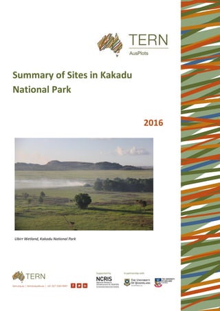
- 1. Ubirr Wetland, Kakadu National Park Summary of Sites in Kakadu National Park 2016
- 2. Acknowledgments AusPlots gratefully acknowledges the staff from Kakadu National Park, in particular Kasia Gabrys, for their help and support of the Project. AusPlots also acknowledges and thanks the traditional owners of Kakadu for allowing access to their land. Thanks are also due the the volunteers who helped out with the field work and the curation and processing of the data and samples and to the staff at the NT Herbarium for undertaking the plant identfications
- 3. Contents Introduction......................................................................................................................................................... 1 Accessing the Data............................................................................................................................................... 3 Point intercept data .................................................................................................................................... 3 Plant collections.......................................................................................................................................... 3 Leaf tissue samples...................................................................................................................................... 3 Site description information........................................................................................................................ 3 Structural summary..................................................................................................................................... 3 Leaf Area Index ........................................................................................................................................... 3 Basal area.................................................................................................................................................... 3 Soil classification ......................................................................................................................................... 4 Soil meta barcoding samples....................................................................................................................... 4 Soil bulk density .......................................................................................................................................... 4 3D Photo Panorama .................................................................................................................................... 4 Regional Context.................................................................................................................................................. 7 Potential Uses for AusPlots Data from Kakadu National Park.............................................................................. 10 For more information ........................................................................................................................................ 10 Appendices........................................................................................................................................................ 11 Appendix 1. Summary of AusPlots data and samples from within Kakadu National Park ........................................ 11 Appendix 2. Co-location with existing plots............................................................................................................ 12 Appendix 3. Plot locations ..................................................................................................................................... 13 Appendix 4. Point intercept data ........................................................................................................................... 14 Appendix 5. Substrate and growth form ................................................................................................................ 16 Appendix 6. Structural Summary............................................................................................................................ 18 Appendix 7. Soil Classification................................................................................................................................ 19 Appendix 8. Bulk density........................................................................................................................................ 20 Appendix 9. Plant collection................................................................................................................................... 21
- 4. 1 Introduction In 2016, AusPlots, part of the Terrestrial Ecosystems Research Network (TERN), undertook surveys in Kakadu National Park. The surveys involved vegetation and soils work following the AusPlots Rangelands methodology, with 6 plots completed. The plots are part of over 580 plots completed nationally. Figure 1 shows the national AusPlots plot network, and Figure 2 shows the locations of the plots in Kakadu National Park. This report provides a snapshot of some of the data which was collected during the survey work. A more detailed description of the methods used can be found online in our AusPlots Rangelands Survey Protocols Manual (White et al. 2012), available from our website www.ausplots.org. Figure 1. AusPlots plot network LandSat Image used courtesy of the Commonwealth Department of the Environment
- 5. 2 Figure 2. AusPlots Rangelands plot locations in Kakadu National Park Topographic data copyright Geoscience Australia
- 6. 3 Accessing the Data All of the data the AusPlots collects is freely available online through the AEKOS data portal at www.aekos.org.au. It can also be viewed on the Soils to Satellites website which contains a range of useful visualisations sourced from the Atlas of Living Australia. At http://www.soils2satellites.org.au/. Point intercept data The point intercept method is a straightforward method that is readily repeatable and requires little instruction to produce reliable plot information. It provides accurate benchmark data at each plot including substrate type and cover; as well as species structural information such as growth form, height, cover and abundance and population vertical structure. The demographic information produced at each plot can be compared spatially to indicate plot differences, and temporally to indicate change over time. Additionally, the cover data collected at each plot can be used to validate cover data extrapolated through remote sensing techniques. Plant collections Each species thatis found withinthe plot has a herbarium grade sample taken. These have all beenformally identified by the NT herbarium. Much of the material is then lodged at the NT herbarium or at the Ausplots facility in Adelaide. Leaf tissue samples All of the above samples also have leaf tissue samples taken. This involves placing leaf samples from each species into a cloth bag and drying them on silica desiccant. All of the dominant species have an extra 4 samples collected. These samples are available for use on application to Ausplots facility in Adelaide. They are able to be used for genetic analysis, Isotopic composition and range of other uses. Site description information Contextual information is also collected at each site. This includes measures of slope an aspect, surface strew and lithology, and information on the grazing and fire history of the site. The sites location is also recorded with a differential GPS and the plot corners and centres (with landholder permission) marked with a star picket. Structural summary Detailed structural summary information is also collected at each site. When combined with the height and cover information from the point intercept data it enables the creation of structural description compatible with and NVIS level 5 description. Leaf Area Index In plots where a mid and/or upper canopy is present a measure of Leaf Area is recorded. The tool used is an LAI- 2200 and it captures LAI measurements in a range of canopies using one or two sensors attached to a single data logger (LI-COR 1990). The LAI data has a range of potential application such as studies of canopy growth, canopy productivity, woodland vigour, canopy fuel load, air pollution deposition, modelling insect defoliation, remote sensing, and the global carbon cycle. Basal area Basal area measurements are collected across plots where woody biomass is taller than 2m. Basal area measurements provide information useful for calculating biomass and carbon levels and for structural studies. The wedge aperture, the length of string – 50 cm (and hence the distance from the eye and subsequent angle from the eye to the edges of the wedge aperture) and species count are all important in calculations. Algorithms developed for use with the basal wedge include the above data to calculate plant basal area on a per hectare basis even though species are counted outside the one hectare plot area. The method is plotless but used because it is based on the
- 7. 4 concept of circles (trunks/basal area) within circles (circular plots) – the area of one varies proportionally to the change in the area of the other. Use of the basal wedge may be superseded by further improvement of the 3D photo point method and development of algorithms to provide information on vegetation community structure. Soil classification Soils descriptions i.e. information recorded, number of recordings and coverage of locations, are generally poor across the rangelands region of Australia. The plot descriptions and soil characterisations collected will substantially alleviate this paucity of information. The data collected can also be used to increase the reliability of the rangelands component of the Soil and Landscape Grid of Australia, produced by the TERN facility consistent with the Global Soil Map specifications. Analyses of the collected samples will greatly enhance the level of knowledge (e.g. nutrient and carbon levels) and hence understanding of rangelands soils and how they will respond to climate change and management options. It is hoped to eventually be able to analyse all 9 of the soil pits from within the plot using a number of different methods e.g. wet chemistry, MIR or NIR (mid infrared spectrometry or near infrared spectroscopy) either individually to provide a measure of variation of the parameter being measured across a plot or bulked together and a sub-sample extracted and analysed to provide a mean value for that parameter across a plot. Soil meta barcoding samples Metagenomics is the study of genetic material recovered directly from environmental samples. Soil metagenomics provides the opportunity to understand what organisms are present at survey plots and provides an indication on their abundance. The collection techniques result in a bias towards higher order organisms. All of the Ausplots within Kakadu National Park have soil meta barcoding samples collected. Soil bulk density The soil bulk density (BD), also known as dry bulk density, is the weight of dry soil divided by the total soil volume. The total soil volume is the combined volume of solids and pores which may contain air or water, or both. The average values of air, water and solid in soil are easily measured and are a useful indication of a soils physical condition. Soil test results are most often presented either as a percentage of soil (e.g. % organic carbon) or as a weight per unit of soil (e.g. nitrogen, mg/kg). As bulk density is a measure of soil weight in a given volume, it provides a useful conversion from these units to an area basis unit (e.g. t/ha). The resulting number gives an easily understandable idea of the carbon storage or nutritional status of the soil on an area basis. 3D Photo Panorama AusPlots uses a three dimensional method for photographing the site. This involves taking three 360 degree panoramas in a triangular pattern. This allows the creation of a 3D model of the vegetation within the site which can be used to monitor change over time, track plot condition as well as providing a unique, fast measurement of basal area and biomass. Photo panoramas for each of the plots are shown below.
- 10. 7 Regional Context Figure 3. Modelled 9s elevation Data from: Xu and Hutchinson, 2011. ANUCLIM Version 6.1. Fenner School of Environment and Society, Australian National University, Australia.
- 11. 8 Figure 4. Mean annual temperature Data from: Xu and Hutchinson, 2011. ANUCLIM Version 6.1. Fenner School of Environment and Society, Australian National University, Australia.
- 12. 9 Figure 5. Mean annual Precipitation Climate Data from: Xu and Hutchinson, 2011. ANUCLIM Version 6.1. Fenner School of Environment and Society, Australian National University, Australia.
- 13. 10 Potential Uses for AusPlots Data from Kakadu National Park The AusPlots survey method was developed out of a dire need for consistent, national scale ecological data and surveillance monitoring. As such, the data can be used in a range of ways both in Kakadu National Park but also to allow comparisons across the continent. Currently, a range of researchers and land managers make use of the data and samples. Some example applications that may be applicable within the region are listed below. • Assessing vegetation change using the AusPlots methodology as both a baseline and a continued surveillance monitoring tool. • Detecting the impact of invasive species based on soil and vegetation data. • Ground-truthing satellite derived vegetation and soil data • Soil carbon analysis using the soil bulk density samples • Mapping soil phosphorus, nitrogen and other nutrients using soil pit and subsite samples • Assessing fuel loading using the basal area and leaf area data. • Use of the leaf tissue samples for genetic and isotopic analysis. For more information More information on the AusPlots facility can be found on our website www.AusPlots.org For more information regarding the survey work in Kakadu National Park and assistance downloading and utilising the data from AEKOS and Soils2Satellites contact Emrys Leitch, AusPlots Field Survey Officer, emrys.leitch@adelaide.edu.au For more information regarding the AusPlots facility, contact Ben Sparrow, AusPlots Director, ben.sparrow@adelaide.edu.au
- 14. 11 Appendices Appendix 1. Summary of AusPlots data and samples from within Kakadu National Park AusPlots Data and Samples Count Total Collections 381 Total Species 216 Total Leaf Tissue Samples 415 Total number of soil samples 143 Total weight of soil (kg) 143 Number of sites with Bulk Density data 5 Number of Sites with LAI 5 Number of Sites with Basal wedge 3 Total metagenomic samples 54 Total metagenomic weight (kg) 27
- 15. 12 Appendix 2. Co-location with existing plots AusPlots works on a mix of both new plots (where this is little existing monitoring infrastructure) and co-location with existing plots. The plots in Kakadu National Park, are co-located with sites from TERN’s Australian Transect Networks NATT transect. The table below provides the name of the AusPlots site and the corresponding site AusPlots name Plot name Organisation Contact NTAARP0001 KS1 TERN Australian transect Network Alan Anderson NTAARP0002 KS2 TERN Australian transect Network Alan Anderson NTAARP0003 KS3 TERN Australian transect Network Alan Anderson NTADAC0002 KN1 TERN Australian transect Network Alan Anderson NTAGFU0041 MA1 TERN Australian transect Network Alan Anderson NTAMGD0003 NW1 TERN Australian transect Network Alan Anderson NTAMGD0004 NW3 TERN Australian transect Network Alan Anderson NTAMGD0005 NW2 TERN Australian transect Network Alan Anderson NTAPCK0001 KN2 TERN Australian transect Network Alan Anderson NTAPCK0002 KN3 TERN Australian transect Network Alan Anderson NTASTU0001 MD3 TERN Australian transect Network Alan Anderson NTASTU0002 MD2 TERN Australian transect Network Alan Anderson NTASTU0003 MD1 TERN Australian transect Network Alan Anderson NTASTU0004 MA2 TERN Australian transect Network Alan Anderson NTASTU0005 MA3 TERN Australian transect Network Alan Anderson
- 16. 13 Appendix 3. Plot locations Plot Name Date Location latitude longitude NTAARP0001 02-Jun-16 Kakadu National Park, 37km west of Gimbat homestead. 56.5km north east of Pine Creek 132.27008 -13.55728 NTAARP0002 02-Jun-16 Kakadu National Park, 34.5km west of Gimbat homestead. 58.5km north east of Pine Creek 132.29434 -13.54561 NTAARP0003 03-Jun-16 Kakadu National park. 18km west north west of Gimbat homestead. 75km north east of pine Creek. 132.45706 -13.51698 NTADAC0002 06-May-16 Kakadu National Park, 20km south of Kapalga homestead. 53.8km west south west of Jabiru. 132.34034 -12.73922 NTAPCK0001 04-May-16 Kakadu National Park, 338m south east of Bowali visitors centre. 1.4km west of Jabiru 132.8181 -12.67578 NTAPCK0002 05-May-16 Kakadu National Park, 2.9km west of Baroalba homestead. 16.5km south south east of Jabiru 132.79345 -12.82043
- 17. 14 Appendix 4. Point intercept data Plot name Herbarium ID Common name Approx. % cover NT cons. code NTAARP0001 Eucalyptus tetrodonta Darwin Stringybark 33.17 NTAARP0001 Heteropogon triticeus Giant Speargrass 11.49 NTAARP0001 Triodia sp. 'Spinifex' 8.51 NTAARP0001 Sorghum sp. 7.03 NTAARP0001 Erythrophleum chlorostachys Camel Poison 6.63 NTAARP0001 Acacia mimula 5.45 NTAARP0001 Buchanania obovata Green Plum 2.18 NTAARP0001 Thaumastochloa sp. 2.08 NTAARP0001 Terminalia carpentariae 1.68 NTAARP0001 Owenia vernicosa Emu Apple 1.58 NTAARP0001 Terminalia ferdinandiana Green Plum 1.49 NTAARP0001 Grevillea goodii 1.19 NTAARP0001 Brochychiton megaphyllus 1.19 NTAARP0001 Persoonia falcata Booral 1.19 NTAARP0001 Samadera sp. Mary River 0.40 Near Threatened NTAARP0001 Aristida longicollis Bull Wiregrass 0.40 Near Threatened NTAARP0002 Eucalyptus tetrodonta Darwin Stringybark 20.30 NTAARP0002 Sorghum sp. Sorghum 16.14 NTAARP0002 Triodia sp. 'Spinifex' 4.16 NTAARP0002 Eriachne sp. 3.56 NTAARP0002 Acacia mimula 3.27 NTAARP0002 Arthrostylis aphylla 2.87 NTAARP0002 Sauropus stenocladus subsp. pinifolius 1.19 NTAARP0002 Petalostigma quadriloculare Bitter Crab 1.19 NTAARP0002 Erythrophleum chlorostachys Camel Poison 1.09 NTAARP0003 Eucalyptus tetrodonta Darwin Stringybark 7.13 NTAARP0003 Sorghum sp. Sorghum 4.75 NTAARP0003 Eucalyptus miniata Bogong Gum 3.07 NTAARP0003 Eucalyptus tintinnans Hills salmon gum 2.87 NTAARP0003 Corymbia dichromophloia Small-fruited bloodwood 2.48 NTAARP0003 Xanthostemon paradoxus Northern Penda 1.98 NTAARP0003 Gardenia megasperma Wild Gardenia 1.88 NTAARP0003 Terminalia ferdinandiana Green Plum 1.39 NTAARP0003 Corymbia ferruginea 1.09 NTADAC0002 Heteropogon triticeus Giant Speargrass 22.28 NTADAC0002 Eucalyptus tetrodonta Darwin Stringybark 14.65 NTADAC0002 Eucalyptus miniata Bogong Gum 14.16 NTADAC0002 Sorghum intrans 12.38 NTADAC0002 Livistona humilis 11.19
- 18. 15 Plot name Herbarium ID Common name Approx. % cover NT cons. code NTADAC0002 Erythrophleum chlorostachys Camel Poison 6.14 NTADAC0002 Acacia mimula 2.77 NTADAC0002 Digitaria gibbosa 1.98 NTADAC0002 Clerodendrum tatei 1.09 NTADAC0002 Hibbertia juncea 1.09 NTAPCK0001 Sorghum 32.87 NTAPCK0001 Petalostigma quadriloculare Bitter Crab 22.28 NTAPCK0001 Eucalyptus miniata Bogong Gum 14.16 NTAPCK0001 Eucalyptus tetrodonta Darwin Stringybark 6.93 NTAPCK0001 Erythrophleum chlorostachys Camel Poison 6.24 NTAPCK0001 Heteropogon triticeus Giant Speargrass 3.07 NTAPCK0001 Corymbia porrecta Grey bloodwood 3.07 NTAPCK0001 Eucalyptus tetrodonta 2.08 NTAPCK0001 Dodonaea hispidula var. hispidula 1.98 NTAPCK0001 Corymbia bleeseri Glossy-leaved bloodwood 1.49 NTAPCK0001 Spermacoce aequabilis 1.09 NTAPCK0002 Heteropogon triticeus Giant Speargrass 11.88 NTAPCK0002 Eucalyptus tetrodonta Darwin Stringybark 9.70 NTAPCK0002 Chrysopogon latifolius Broadleaf Ribbon grass 8.22 NTAPCK0002 Corymbia sp. Bloodwoods 6.34 NTAPCK0002 Eucalyptus miniata Bogong Gum 5.15 NTAPCK0002 Terminalia sp. Pagoda Trees 4.55 NTAPCK0002 Petalostigma quadriloculare Bitter Crab 4.46 NTAPCK0002 Panicum mindanaense 4.36 NTAPCK0002 Chrysopogon fallax & Eulalia mackinlayi 4.16 NTAPCK0002 Desmodium pullenii 4.06 NTAPCK0002 Annual Grass 3.76 NTAPCK0002 Flemingia parviflora 2.97 NTAPCK0002 Galactia tenuiflora? 2.77 NTAPCK0002 Pseudopogonatherum contortum 1.19
- 19. 16 Appendix 5. Substrate and growth form Plot name Substrate Approx. % substrate Plot name Growth form Approx. % cover by growth form NTAARP0001 Leaf litter 93.56 NTAARP0001 Tree/Palm 52.28 NTAARP0001 Bare ground 5.45 NTAARP0001 Tussock grass 23.76 NTAARP0001 Coarse woody debris 0.89 NTAARP0001 Hummock grass 8.51 NTAARP0001 Not collected 0.10 NTAARP0001 Shrub 7.33 NTAARP0001 Forb 4.85 NTAARP0001 Sedge 0.40 Plot name Substrate Approx. % substrate Plot name Growth form Approx. % cover by growth form NTAARP0002 Leaf litter 87.13 NTAARP0002 Tree/Palm 24.16 NTAARP0002 Bare ground 12.18 NTAARP0002 Tussock grass 20.50 NTAARP0002 Coarse woody debris 0.69 NTAARP0002 Shrub 6.44 NTAARP0002 Forb 4.65 NTAARP0002 Hummock grass 4.26 NTAARP0002 Sedge 3.56 NTAARP0002 Rush 0.50 NTAARP0002 Vine 0.20 Plot name Substrate Approx. % substrate Plot name Growth form Approx. % cover by growth form NTAARP0003 Leaf litter 64.75 NTAARP0003 Tree/Palm 20.50 NTAARP0003 Bare ground 17.23 NTAARP0003 Shrub 11.88 NTAARP0003 Gravel 16.93 NTAARP0003 Tussock grass 6.93 NTAARP0003 Cryptogam 0.50 NTAARP0003 Hummock grass 0.89 NTAARP0003 Coarse woody debris 0.30 NTAARP0003 Forb 0.59 NTAARP0003 Rock 0.20 NTAARP0003 Vine 0.30 NTAARP0003 Outcrop 0.10 NTAARP0003 Heath-shrub 0.10 NTAARP0003 Epiphyte 0.10 Plot name Substrate Approx. % substrate Plot name Growth form Approx. % cover by growth form NTADAC0002 Leaf litter 78.32 NTADAC0002 Tree/Palm 28.32 NTADAC0002 Bare ground 13.96 NTADAC0002 Shrub 25.45 NTADAC0002 Cryptogam 4.85 NTADAC0002 Tussock grass 24.65 NTADAC0002 Gravel 2.38 NTADAC0002 Forb 15.94 NTADAC0002 Unknown 0.30 NTADAC0002 Sedge 0.10 NTADAC0002 Coarse woody debris 0.20 NTADAC0002 Tree Mallee 0.10
- 20. 17 Plot name Substrate Approx. % substrate Plot name Growth form Approx. % cover by growth form NTAPCK0001 Leaf litter 93.37 NTAPCK0001 Shrub 37.03 NTAPCK0001 Gravel 5.35 NTAPCK0001 Tussock grass 36.63 NTAPCK0001 Coarse woody debris 0.79 NTAPCK0001 Tree/Palm 27.82 NTAPCK0001 Bare ground 0.20 NTAPCK0001 Forb 4.95 NTAPCK0001 Outcrop 0.20 NTAPCK0001 Vine 0.20 NTAPCK0001 Rock 0.10 Plot name Substrate Approx. % substrate Plot name Growth form Approx. % cover by growth form NTAPCK0002 Leaf litter 79.70 NTAPCK0002 Tussock grass 34.85 NTAPCK0002 Gravel 12.97 NTAPCK0002 Tree/Palm 26.44 NTAPCK0002 Bare ground 6.34 NTAPCK0002 Shrub 12.38 NTAPCK0002 Cryptogam 0.59 NTAPCK0002 Forb 11.58 NTAPCK0002 Coarse woody debris 0.40
- 21. 18 Appendix 6. Structural Summary Plot name Structural description NTAARP0001 Eucalyptus tetrodonta woodland with Erythrophleum chlorostachys and Acacia mimula. A sparse mid story Acacia mimula, juvenile Eucalyptus tetrodonta, Buchanania obovata and Terminalia ferdinandiana. Ground stratum dominated by Sorghum sp., Heteropogon triticeus with some Triodia sp. NTAARP0002 Eucalyptus tetrodonta woodland with a mixed mid story dominated by Acacia mimula with some scattered Livistona humilis. Ground stratum dominated by Sorghum sp. (probably S. brachypodum) and Arthrostylis aphylla. NTAARP0003 Eucalyptus tetrodonta, Eucalyptus miniata, Corymbia dichromophloia and Eucalyptus tintinnans mixed woodland. A mid stratum dominated by Acacia oncinocarpa with some Petalostigma pubescens. Ground stratum mostly burnt out in low intensity fire but some regeneration and dominated by Sorghum sp. (probably S. brachypodum) with Aristida and Triodia. NTADAC0002 Eucalyptus miniata and Eucalyptus tetrodonta mixed woodland. A mid story dominated by Erythrophleum chlorostachys, Livistona humilis and Acacia mimula. Ground layer dominated by Heteropogon triticeus and Sorghum intrans. NTAPCK0001 Eucalyptus miniata/ Eucalyptus tetrodonta mixed woodland with a mid-story of juvenile Eucalyptus and Corymbia. Lower mid story dominated by Petalostigma quadriloculare and Erythrophleum chlorostachys Ground layer dominated by Tussock grasses- Sorghum sp., Heteropogon triticeus and Thaumastochloa major. NTAPCK0002 Eucalyptus miniata/Eucalyptus tetrodonta, Corymbia sp. mixed woodland with a sparse mid layer and a dense ground layer dominated by Chrysopogon latifolius and Petalostigma quadriloculare.
- 22. 19 Appendix 7. Soil Classification Plot name Upper depth Lower depth Horizon Texture Colour when moist ph. Ec. effervescence NTADAC0002 0.15 0.75 A3 Clayey Sand 7.5YR56 5.8 0.1 Non-calcareous NTAARP0003 0.45 1 Clayey Sand 5YR46 5.6 0.07 Non-calcareous NTAARP001 0.25 1 A32 Clayey Sand 2.5YR46 6.2 0 Non-calcareous NTADAC0002 0.15 0.75 A3 Clayey Sand 5.8 0.1 Non-calcareous NTAARP0003 0 0.16 Loamy Sand 5YR33 5.8 0.08 Non-calcareous NTAARP002 0 0.08 A11 Loamy Sand 5YR33 4.7 0.25 Non-calcareous NTAARP002 0.08 0.75 A12 Loamy Sand 10TY46 5.5 0 Non-calcareous NTAARP002 0.75 1 A13 Loamy Sand 2.5YR2.54 5.2 0 Non-calcareous NTAARP001 0.15 0.25 A31 Loamy Sand 2.5YR36 5.7 0 Non-calcareous NTAPCK00001 0 0.09 A1 Loamy Sand 7.5YR31 6.2 0 Non-calcareous NTADAC0002 0 0.15 A1 Sand 7.5YR31 4.9 0 Non-calcareous NTAARP0003 0.16 0.45 Sand 5YR56 5.3 0.09 Non-calcareous NTAARP001 0 0.03 A11 Sand 5YR34 6.1 0 Non-calcareous NTAARP001 0.03 0.15 A12 Sand 5YR44 5.9 0 Non-calcareous NTADAC0002 0 0.15 A1 Sand 4.9 0 Non-calcareous NTAPCK00001 0.09 0.55 B11 Sandy Loam 5YR46 6.1 0 Non-calcareous NTAPCK00001 0.55 1 B12 Sandy Loam 2.5YR48 6 0 Non-calcareous
- 23. 20 Appendix 8. Bulk density Plot name Sample depth Fine earth weight Fine earth bulk density NTAARP0001 0 to 10cms 309.24 1.48 NTAARP0001 10-20cms 313.05 1.50 NTAARP0001 20-30cms 331.03 1.58 NTAARP0002 0 to 10cms 293.99 1.40 NTAARP0002 10-20cms 311.11 1.49 NTAARP0002 20-30cms 308.05 1.47
- 24. 21 Appendix 9. Plant collection Plot name Herbarium determination Common name NT Cons. Code NTAARP0001 Acacia alleniana NTAARP0001 Acacia dimidiata NTAARP0001 Acacia lamprocarpa Western Salwood NTAARP0001 Acacia mimula NTAARP0001 Alphitonia excelsa Coopers Wood NTAARP0001 Apocynaceae NTAARP0001 Aristida longicollis Bull Wiregrass Near Threatened NTAARP0001 Arthrostylis aphylla NTAARP0001 Bonamia brevifolia NTAARP0001 Boronia decumbens NTAARP0001 Breynia cernua NTAARP0001 Brochychiton megaphyllus NTAARP0001 Buchanania obovata Green Plum NTAARP0001 Cartonema spicatum NTAARP0001 Clerodendrum floribundum Lolly Bush NTAARP0001 Cochlospermum fraseri subsp. fraseri NTAARP0001 Cyperus sporobolus NTAARP0001 Denhamia ferdinandi NTAARP0001 Denhamia obscura Weeping Denhamia NTAARP0001 Desmodium brownii NTAARP0001 Desmodium pycnotrichum NTAARP0001 Dodonaea hispidula NTAARP0001 Dodonaea hispidula var. hispidula NTAARP0001 Eriachne basedowii NTAARP0001 Eriachne ciliata? NTAARP0001 Eriachne triseta NTAARP0001 Erythrophleum chlorostachys Camel Poison NTAARP0001 Eucalyptus tetrodonta Darwin Stringybark NTAARP0001 Eulalia mackinlayi NTAARP0001 Euphorbia muelleri NTAARP0001 Euphorbia schultzii var schultzii NTAARP0001 Exocarpos latifolius Broad Leaved Native Cherry NTAARP0001 Flemingia parviflora NTAARP0001 Gardenia megasperma Wild Gardenia NTAARP0001 Gonocarpus leptothecus NTAARP0001 Goodenia armstrongiana NTAARP0001 Goodenia holtzeana NTAARP0001 Grevillea goodii NTAARP0001 Heteropogon triticeus Giant Speargrass NTAARP0001 Hibbertia dealbata NTAARP0001 Hibbertia echiifolia subsp. Oligantha
- 25. 22 Plot name Herbarium determination Common name NT Cons. Code NTAARP0001 Hibbertia juncea NTAARP0001 Hibbertia sphenandra NTAARP0001 Livistona humilis Sand Palm NTAARP0001 Mardenia viridiflora NTAARP0001 Marsdenia connivens NTAARP0001 Marsdenia viridiflora Native Pear NTAARP0001 Murdannia graminea Grass Lily NTAARP0001 Opilia amentacea NTAARP0001 Owenia vernicosa Emu Apple NTAARP0001 Persoonia falcata Booral NTAARP0001 Petalostigma pubescens Bitter Bark NTAARP0001 Planchonia careya Billygoat Plum NTAARP0001 Polycarpaea corymbosa NTAARP0001 Samadera sp. Mary River Near Threatened NTAARP0001 Sauropus brunonis NTAARP0001 Schizachyrium pseudeulalia NTAARP0001 Sorghum plumosum Plume Sorghum NTAARP0001 Spermacoce leptoloba NTAARP0001 Sporobolus pulchellus Pretty Sporobolus NTAARP0001 Stylidium semipartitum NTAARP0001 Tephrosia porrecta NTAARP0001 Tephrosia remotiflora NTAARP0001 Terminalia carpentariae NTAARP0001 Terminalia ferdinandiana Green Plum NTAARP0001 Trachymene rotundifolia NTAARP0001 Urochloa holosericea subsp. Holosericea NTAARP0001 Yakirra nulla NTAARP0002 Acacia alleniana NTAARP0002 Acacia latescens Ball Wattle NTAARP0002 Acacia mimula NTAARP0002 Acacia oncinocarpa NTAARP0002 Acacia torulosa Torulosa Wattle NTAARP0002 Aristida holathera Erect Kerosene Grass NTAARP0002 Arthrostylis aphylla NTAARP0002 Blepharocarya depauperata North Queensland Bollygum NTAARP0002 Boronia decumbens NTAARP0002 Calytrix exstipulata Kimberley Heath NTAARP0002 Capparis umbonata Native Promegranate NTAARP0002 Cartonema spicatum NTAARP0002 Cassytha capillaris Dodder Laurel NTAARP0002 Denhamia ferdinandi NTAARP0002 Ehretia saligna Coonta
- 26. 23 Plot name Herbarium determination Common name NT Cons. Code NTAARP0002 Eriachne basedowii NTAARP0002 Eriachne nodosa NTAARP0002 Erythrophleum chlorostachys Camel Poison NTAARP0002 Eucalyptus tetrodonta Darwin Stringybark NTAARP0002 Euphorbia muelleri NTAARP0002 Fimbristylis squarrulosa NTAARP0002 Gardenia megasperma Wild Gardenia NTAARP0002 Gardenia resinosa subsp. resinosa NTAARP0002 Gomphrena canescens subsp. Canescens NTAARP0002 Goodenia holtzeana NTAARP0002 Grevillea goodii NTAARP0002 Grevillea pteridifolia Darwin Silky Oak NTAARP0002 Heliotropium foliatum NTAARP0002 Hibbertia juncea NTAARP0002 Hibbertia lepidota NTAARP0002 Jacksonia dilatata NTAARP0002 Livistona humilis Sand Palm NTAARP0002 Lomandra tropica NTAARP0002 Lomandra tropica subsp. Tropica NTAARP0002 Marsdenia trinervis NTAARP0002 Marsdenia viridiflora Native Pear NTAARP0002 Owenia vernicosa Emu Apple NTAARP0002 Pandanus spiralis Common Screwpine NTAARP0002 Persoonia falcata Booral NTAARP0002 Petalostigma quadriloculare Bitter Crab NTAARP0002 Planchonella arnhemica Gulf Coondoo NTAARP0002 Planchonia careya Billygoat Plum NTAARP0002 Polycarpaea staminodina NTAARP0002 Portulaca bicolor Heart-plant NTAARP0002 Ptilotus corymbosus NTAARP0002 Ptilotus distans NTAARP0002 Sauropus stenocladus ssp. Pinifolius NTAARP0002 Schizachyrium fragile Firegrass NTAARP0002 Senna sp. Pine creek NTAARP0002 Sorghum plumosum Plume Sorghum NTAARP0002 Tephrosia porrecta NTAARP0002 Terminalia carpentariae NTAARP0002 Thaumastochloa striata NTAARP0002 Yakirra nulla NTAARP0003 Acacia oncinocarpa NTAARP0003 Buchanania obovata Green Plum NTAARP0003 Buchnera linearis Blackrod
- 27. 24 Plot name Herbarium determination Common name NT Cons. Code NTAARP0003 Calytrix achaeta NTAARP0003 Cartonema spicatum NTAARP0003 Corymbia dichromophloia Small-fruited bloodwood NTAARP0003 Corymbia ferruginea NTAARP0003 Eriachne avenacea NTAARP0003 Eriachne schultziana NTAARP0003 Erythrophleum chlorostachys Camel Poison NTAARP0003 Eucalyptus miniata Bogong Gum NTAARP0003 Eucalyptus tetrodonta Darwin Stringybark NTAARP0003 Eucalyptus tintinnans Hills salmon gum NTAARP0003 Euphorbia schultzii var. schultzii NTAARP0003 Gardenia megasperma Wild Gardenia NTAARP0003 Goodenia holtzeana NTAARP0003 Goodenia janamba NTAARP0003 Grevillea decurrens NTAARP0003 Indigofera pratensis Forest Indigo NTAARP0003 Livistona inermis NTAARP0003 Persoonia falcata Booral NTAARP0003 Petalostigma pubescens Bitter Bark NTAARP0003 Sauropus dunlopii NTAARP0003 Spermacoce? calliantha NTAARP0003 Stackhousia intermedia NTAARP0003 Stemodia lythrifolia Bunu Bunu NTAARP0003 Stylidium multiscapum NTAARP0003 Stylidium semipartitum NTAARP0003 Terminalia ferdinandiana Green Plum NTAARP0003 Xanthostemon paradoxus Northern Penda NTADAC0002 Acacia difficilis NTADAC0002 Acacia mimula NTADAC0002 Alphitonia excelsa Coopers Wood NTADAC0002 Arthrostylis aphylla NTADAC0002 Brachychiton diversifolius subsp diversifolius NTADAC0002 Brachychiton megaphyllus NTADAC0002 Buchanania obovata Green Plum NTADAC0002 Bulbostylis barbata NTADAC0002 Cartonema spicatum NTADAC0002 Clerodendrum floribundum Lolly Bush NTADAC0002 Clerodendrum tatei NTADAC0002 Corymbia ptychocarpa Red Bloodwood NTADAC0002 Crotalaria medicaginea Trefoil Rattlepod NTADAC0002 Crotalaria montana NTADAC0002 Crotalaria montara
- 28. 25 Plot name Herbarium determination Common name NT Cons. Code NTADAC0002 Dendrophthoe glabrescens Orange Mistletoe NTADAC0002 Digitaria gibbosa NTADAC0002 Ectrosia agrostoides NTADAC0002 Eragrostis fallax NTADAC0002 Eriachne triseta NTADAC0002 Erythrophleum chlorostachys Camel Poison NTADAC0002 Eucalyptus miniata Bogong Gum NTADAC0002 Eucalyptus tetrodonta Darwin Stringybark NTADAC0002 Grevillea decurrens NTADAC0002 Helicteres flagellaris NTADAC0002 Heteropogon triticeus Giant Speargrass NTADAC0002 Hibbertia cistifolia NTADAC0002 Hibbertia juncea NTADAC0002 Livistonia humilis NTADAC0002 Lophostemon grandiflorus NTADAC0002 Pandanus spiralis Common Screwpine NTADAC0002 Persoonia falcata Booral NTADAC0002 Petalostigma quadriloculare Bitter Crab NTADAC0002 Planchonella arnhemica Gulf Coondoo NTADAC0002 Planchonia careya Billygoat Plum NTADAC0002 Polygala coralliformis or barbata NTADAC0002 Pseudopogonatherum irritans NTADAC0002 Sauropus brunonis NTADAC0002 Sauropus stenocladus subsp. stenocladus NTADAC0002 Setaria surgens Pearl Millet NTADAC0002 Sorghum intrans NTADAC0002 Sorghum plumosum Plume Sorghum NTADAC0002 Spermacoce discreta NTADAC0002 Sporobolus australasicus Australian Dropseed NTADAC0002 Stylidium semipartitum NTADAC0002 Terminalia ferdinandiana Green Plum NTADAC0002 Thecanthes punicea NTADAC0002 Xanthostemon paradoxus NTAPCK0001 Acacia lamprocarpa Western Salwood NTAPCK0001 Acacia mimula NTAPCK0001 Alloteropsis semialata Cockatoo grass NTAPCK0001 Ampelocissus frutescens NTAPCK0001 Brachychiton megathyllus NTAPCK0001 Buchanania obovata Green Plum NTAPCK0001 Buchnera linearis Blackrod NTAPCK0001 Bulbostylis barbata NTAPCK0001 Calytrix brownii Fringe-myrtle
- 29. 26 Plot name Herbarium determination Common name NT Cons. Code NTAPCK0001 Cassytha filiformis Dodder Laurel NTAPCK0001 Cochlospermum fraseri subsp. fraseri NTAPCK0001 Coelospermum reticulatum Medicine Bush NTAPCK0001 Corymbia bleeseri Glossy-leaved bloodwood NTAPCK0001 Corymbia porrecta Grey bloodwood NTAPCK0001 Crotalaria montana NTAPCK0001 Denhamia obscura Weeping Denhamia NTAPCK0001 Desmodium pullenii NTAPCK0001 Digitaria gibbosa NTAPCK0001 Dodonoea hispidula var. hispidula NTAPCK0001 Dolichandrone filiformis NTAPCK0001 Eriachne agrostidea NTAPCK0001 Eriachne avenacea NTAPCK0001 Eriachne ciliata Slender Wanderrie Grass NTAPCK0001 Erythrophleum chlorostachys Camel Poison NTAPCK0001 Eucalyptus miniata Bogong Gum NTAPCK0001 Eucalyptus tetrodonta Darwin Stringybark NTAPCK0001 Euphorbia schultzii NTAPCK0001 Eurybiopsis macrorhiza NTAPCK0001 Galactia tenuiflora NTAPCK0001 Gomphrena canescens sub species erythrina NTAPCK0001 Goodenia holtzeana NTAPCK0001 Grevillea mimosoides Caustic Bush NTAPCK0001 Heteropogon triticeus Giant Speargrass NTAPCK0001 Ipomoea diversifolia NTAPCK0001 Jasminum molle NTAPCK0001 Livistona humilis Sand Palm NTAPCK0001 Marsdenia connivens NTAPCK0001 Marsdenia trinerve NTAPCK0001 Mitrasacme connata NTAPCK0001 Mnesithea formosa NTAPCK0001 Petalostigma quadriloculare Bitter Crab NTAPCK0001 Polycarpaea holtzei NTAPCK0001 Polygala coralliformis NTAPCK0001 Polygala parviloba NTAPCK0001 Portulaca bicolor Heart-plant NTAPCK0001 Premna acuminata Firestick Tree NTAPCK0001 Ptilotus corymbosus NTAPCK0001 Sorghum NTAPCK0001 Spermacoce aequabilis NTAPCK0001 Spermaeoce stenophylla NTAPCK0001 Stenocarpus acaciodes
- 30. 27 Plot name Herbarium determination Common name NT Cons. Code NTAPCK0001 Tephrosia remotiflora NTAPCK0001 Terminalia ferdinandiana Green Plum NTAPCK0001 Terminalia volucris Rosewood NTAPCK0001 Terminalis ferdinandiana NTAPCK0001 Thaumastochloa major NTAPCK0001 Tribulopis angustifolia NTAPCK0001 Tribulopis pentandra NTAPCK0001 Waltheria indica NTAPCK0001 Wrightia saligrina NTAPCK0001 Xanthostemon paradoxus NTAPCK0001 Xanthostermon paradoxus NTAPCK0002 Alphitonia excelsa Coopers Wood NTAPCK0002 Anisomeles leucotricha NTAPCK0002 Antidesma ghesaembilla NTAPCK0002 Brachychiton megaphyllus NTAPCK0002 Buchnera linearis Blackrod NTAPCK0002 Chrysopogon latifolius Broadleaf Ribbon grass NTAPCK0002 Clerodendrum floribundum Lolly Bush NTAPCK0002 Cochlospermum fraseri subsp. fraseri NTAPCK0002 Crotalaria medicaginea Trefoil Rattlepod NTAPCK0002 Denhamia obscura Weeping Denhamia NTAPCK0002 Desmodium pullenii NTAPCK0002 Digitaria gibbosa NTAPCK0002 Eucalyptus miniata Bogong Gum NTAPCK0002 Eucalyptus tetrodonta Darwin Stringybark NTAPCK0002 Euphorbia schultzii var. schultzii NTAPCK0002 Flemingia parviflora NTAPCK0002 Goodenia armstrongiana NTAPCK0002 Haemodorum coccineum Scarlet-flowered Blood-root NTAPCK0002 Helicteres cana subsp. Latifolia NTAPCK0002 Heteropogon triticeus Giant Speargrass NTAPCK0002 Hybanthus enneaspermus Spade Flower NTAPCK0002 Jasminum molle NTAPCK0002 Livistona humilis Sand Palm NTAPCK0002 Owenia vernicosa Emu Apple NTAPCK0002 Panicum mindanaense NTAPCK0002 Petalostigma quadriloculare Bitter Crab NTAPCK0002 Phyllanthus flagellaris NTAPCK0002 Polygala coralliformis NTAPCK0002 Polygala parviloba NTAPCK0002 Pseudopogonatherum contortum NTAPCK0002 Pseudopogonatherum irritans
- 31. 28 Plot name Herbarium determination Common name NT Cons. Code NTAPCK0002 Scleria brownii NTAPCK0002 Sporobolus pulchellus Pretty Sporobolus NTAPCK0002 Tacca leontopetaloides NTAPCK0002 Tephrosia remotiflora NTAPCK0002 Uraria lagopodioides NTAPCK0002 Xenostegia tridentata NTAPCK0002 Yakirra nulla