SlideShare a Scribd company logo
1 of 1
Calibration and deployment of a 3D P-cable to collect evidence of climate change
Tyler Hackett, MATE intern (summer 2015)
Advisor: Dr.Gregory Mountain, Robert Steinhaus
The objective of this project was to obtain acoustic images of
the geologic record of climate change from the continental
shelf 30km to 80km off the coastline of New Jersey. The
research was conducted over a period of six weeks during the
summer of 2015. Two seismic acquisition systems were used
to collect the data, a three-kilometer hydrophone streamer
which was used to accurately measure sound velocities to
calibrate the P-Cable, which was the main acquisition system.
• 235 Ft (71 m)
• 55 personnel
DEPLOYMENT / RECOVERY
OBJECTIVE OPERATION
RV Langseth SIESMIC SOURCE
• 4 Bolt air guns
• 700 in3 Total @ 2000 PSI
P-CABLE SYSTEM
• 24 streamers
• 96 Hydrophones per
streamer
• 12.5 meters apart
SET-UP
Navigation of the entire seismic survey was completed using
NCS Subsea technologies. Attached to each of the GPS
buoys, paravanes, and seismic source was a GPS that
communicated with the navigation software. This software
gave a visual representation of the orientation of the seismic
equipment and the area of the prospect where data was
obtained as seen by the green on the map below.
While obtaining data each individual on duty had a specific job.
My main responsibility consisted of starting, monitoring, and
shutting off the single steamer data collection. Another
responsibility of mine was to observe the seismic source string
to make sure there were not any issues. While monitoring I
had to log any events along the line including start and end of
line, any animal power-downs, or technical difficulties.
The deployments of the seismic systems were unique. The
single 3-km long off-set streamer was the first to be deployed.
This included the streamer levelers also known as birds being
attached to control the depth of the streamer as it was towed.
To deploy the full P-Cable system, the single streamer had to
be pulled to the port side. Then the starboard paravane and
GPS buoy were deployed and the P-Cable quickly followed.
After each short streamer was attached to the P-Cable, tests
were performed to make sure the communication was
operating properly. This continued until all 24 streamers were
deployed. The port paravane and port GPS buoy were then
deployed and spooled out to the final position. This process
took every technician on shift to safely and efficiently deploy
the entire system.
My duties consisted of aiding the technicians in safely
deploying the paravanes and GPS buoys. Later on in the
cruise my duties shifted to the more responsible position of
controlling the spare reel that held all of the P-Cable
streamers. I was also able to get hands-on experience
deploying and recovering the seismic source. All of these jobs
required above average communication and focus.
NAVIGATION
P-CABLE SOFTWARE
The P-Cable software that was developed by Geometrics was
used to obtain the data only from the P-Cable system. This
software gives an image of sound reflected off layered
sediments below the sea floor. The real time data is used to
observe if there are any other sounds being picked up that are
not of our interest. These noises include ship noise, issues
with the air source and other interferences. Below is an
example of the software.
The MATE Internship Program is funded by the REU program of the National Science
Foundation’s Division of Ocean Sciences. Since 1999, the MATE internship program has
placed over 300 students in at-sea internships lasting from two weeks to six months. More
information about the program can be obtained at: http://www.marinetech.org/internships/

More Related Content

What's hot

TU4.L10 - FROM A REAL PENCIL TO A SYNTHETIC BROOM: THE PAST, PRESENT AND FUTU...
TU4.L10 - FROM A REAL PENCIL TO A SYNTHETIC BROOM: THE PAST, PRESENT AND FUTU...TU4.L10 - FROM A REAL PENCIL TO A SYNTHETIC BROOM: THE PAST, PRESENT AND FUTU...
TU4.L10 - FROM A REAL PENCIL TO A SYNTHETIC BROOM: THE PAST, PRESENT AND FUTU...grssieee
 
Autonomous Wireless Sensor Networks: from development to long term implementa...
Autonomous Wireless Sensor Networks: from development to long term implementa...Autonomous Wireless Sensor Networks: from development to long term implementa...
Autonomous Wireless Sensor Networks: from development to long term implementa...Integrated Carbon Observation System (ICOS)
 
IGARSS2011_radarvolcanology.pptx
IGARSS2011_radarvolcanology.pptxIGARSS2011_radarvolcanology.pptx
IGARSS2011_radarvolcanology.pptxgrssieee
 
TU2.T10.1.pptx
TU2.T10.1.pptxTU2.T10.1.pptx
TU2.T10.1.pptxgrssieee
 
TH2.L10.5: OVERVIEW ON CALIBRATION AND VALIDATION ACTIVITIES FOR ESA’S SOIL M...
TH2.L10.5: OVERVIEW ON CALIBRATION AND VALIDATION ACTIVITIES FOR ESA’S SOIL M...TH2.L10.5: OVERVIEW ON CALIBRATION AND VALIDATION ACTIVITIES FOR ESA’S SOIL M...
TH2.L10.5: OVERVIEW ON CALIBRATION AND VALIDATION ACTIVITIES FOR ESA’S SOIL M...grssieee
 
IGARSS 2011 - TU4.T05 Clement ALBINET.ppt
IGARSS 2011 - TU4.T05 Clement ALBINET.pptIGARSS 2011 - TU4.T05 Clement ALBINET.ppt
IGARSS 2011 - TU4.T05 Clement ALBINET.pptgrssieee
 
ionospheric scintillation
ionospheric scintillationionospheric scintillation
ionospheric scintillationMohammed Ayalew
 
PR4 IGARSS_2011_BEZY_final.ppt
PR4 IGARSS_2011_BEZY_final.pptPR4 IGARSS_2011_BEZY_final.ppt
PR4 IGARSS_2011_BEZY_final.pptgrssieee
 
CAMS General Assembly EUMETSAT
CAMS General Assembly EUMETSATCAMS General Assembly EUMETSAT
CAMS General Assembly EUMETSATCopernicus ECMWF
 
FR1.L09.2 - ONBOARD RADAR PROCESSING CONCEPTS FOR THE DESDYNI MISSION
FR1.L09.2 - ONBOARD RADAR PROCESSING CONCEPTS FOR THE DESDYNI MISSIONFR1.L09.2 - ONBOARD RADAR PROCESSING CONCEPTS FOR THE DESDYNI MISSION
FR1.L09.2 - ONBOARD RADAR PROCESSING CONCEPTS FOR THE DESDYNI MISSIONgrssieee
 
LAICE Overview - NGC Presentation 12-02-15
LAICE Overview - NGC Presentation 12-02-15LAICE Overview - NGC Presentation 12-02-15
LAICE Overview - NGC Presentation 12-02-15Stephen Noel
 
Remote Sensing Application in Wind Energy
Remote Sensing Application in Wind EnergyRemote Sensing Application in Wind Energy
Remote Sensing Application in Wind EnergySiraj Ahmed
 
20160614 CAMS GA Acquisition by Suttie
20160614 CAMS GA Acquisition by Suttie20160614 CAMS GA Acquisition by Suttie
20160614 CAMS GA Acquisition by SuttieCopernicus ECMWF
 
2005-10-31 Satellite Aerosol Climatology
2005-10-31 Satellite Aerosol Climatology2005-10-31 Satellite Aerosol Climatology
2005-10-31 Satellite Aerosol ClimatologyRudolf Husar
 

What's hot (20)

TU4.L10 - FROM A REAL PENCIL TO A SYNTHETIC BROOM: THE PAST, PRESENT AND FUTU...
TU4.L10 - FROM A REAL PENCIL TO A SYNTHETIC BROOM: THE PAST, PRESENT AND FUTU...TU4.L10 - FROM A REAL PENCIL TO A SYNTHETIC BROOM: THE PAST, PRESENT AND FUTU...
TU4.L10 - FROM A REAL PENCIL TO A SYNTHETIC BROOM: THE PAST, PRESENT AND FUTU...
 
Autonomous Wireless Sensor Networks: from development to long term implementa...
Autonomous Wireless Sensor Networks: from development to long term implementa...Autonomous Wireless Sensor Networks: from development to long term implementa...
Autonomous Wireless Sensor Networks: from development to long term implementa...
 
Maniaci
ManiaciManiaci
Maniaci
 
IGARSS2011_radarvolcanology.pptx
IGARSS2011_radarvolcanology.pptxIGARSS2011_radarvolcanology.pptx
IGARSS2011_radarvolcanology.pptx
 
Calipso
CalipsoCalipso
Calipso
 
CAMS GS Global Analyses
CAMS GS Global Analyses  CAMS GS Global Analyses
CAMS GS Global Analyses
 
TU2.T10.1.pptx
TU2.T10.1.pptxTU2.T10.1.pptx
TU2.T10.1.pptx
 
RoccoPancieraMesiano sept25 2013
RoccoPancieraMesiano sept25 2013RoccoPancieraMesiano sept25 2013
RoccoPancieraMesiano sept25 2013
 
Activities at Wallops Flight Facility
Activities at Wallops Flight FacilityActivities at Wallops Flight Facility
Activities at Wallops Flight Facility
 
TH2.L10.5: OVERVIEW ON CALIBRATION AND VALIDATION ACTIVITIES FOR ESA’S SOIL M...
TH2.L10.5: OVERVIEW ON CALIBRATION AND VALIDATION ACTIVITIES FOR ESA’S SOIL M...TH2.L10.5: OVERVIEW ON CALIBRATION AND VALIDATION ACTIVITIES FOR ESA’S SOIL M...
TH2.L10.5: OVERVIEW ON CALIBRATION AND VALIDATION ACTIVITIES FOR ESA’S SOIL M...
 
IGARSS 2011 - TU4.T05 Clement ALBINET.ppt
IGARSS 2011 - TU4.T05 Clement ALBINET.pptIGARSS 2011 - TU4.T05 Clement ALBINET.ppt
IGARSS 2011 - TU4.T05 Clement ALBINET.ppt
 
ionospheric scintillation
ionospheric scintillationionospheric scintillation
ionospheric scintillation
 
PR4 IGARSS_2011_BEZY_final.ppt
PR4 IGARSS_2011_BEZY_final.pptPR4 IGARSS_2011_BEZY_final.ppt
PR4 IGARSS_2011_BEZY_final.ppt
 
CAMS General Assembly EUMETSAT
CAMS General Assembly EUMETSATCAMS General Assembly EUMETSAT
CAMS General Assembly EUMETSAT
 
Sorce
SorceSorce
Sorce
 
FR1.L09.2 - ONBOARD RADAR PROCESSING CONCEPTS FOR THE DESDYNI MISSION
FR1.L09.2 - ONBOARD RADAR PROCESSING CONCEPTS FOR THE DESDYNI MISSIONFR1.L09.2 - ONBOARD RADAR PROCESSING CONCEPTS FOR THE DESDYNI MISSION
FR1.L09.2 - ONBOARD RADAR PROCESSING CONCEPTS FOR THE DESDYNI MISSION
 
LAICE Overview - NGC Presentation 12-02-15
LAICE Overview - NGC Presentation 12-02-15LAICE Overview - NGC Presentation 12-02-15
LAICE Overview - NGC Presentation 12-02-15
 
Remote Sensing Application in Wind Energy
Remote Sensing Application in Wind EnergyRemote Sensing Application in Wind Energy
Remote Sensing Application in Wind Energy
 
20160614 CAMS GA Acquisition by Suttie
20160614 CAMS GA Acquisition by Suttie20160614 CAMS GA Acquisition by Suttie
20160614 CAMS GA Acquisition by Suttie
 
2005-10-31 Satellite Aerosol Climatology
2005-10-31 Satellite Aerosol Climatology2005-10-31 Satellite Aerosol Climatology
2005-10-31 Satellite Aerosol Climatology
 

Viewers also liked

Viewers also liked (16)

Hou Maolin — Influence of climate change on bionomics of the brown planthoppe...
Hou Maolin — Influence of climate change on bionomics of the brown planthoppe...Hou Maolin — Influence of climate change on bionomics of the brown planthoppe...
Hou Maolin — Influence of climate change on bionomics of the brown planthoppe...
 
Insect pest of rice
Insect pest of riceInsect pest of rice
Insect pest of rice
 
Agility vas dissertation (autosaved) (1)
Agility vas dissertation (autosaved) (1)Agility vas dissertation (autosaved) (1)
Agility vas dissertation (autosaved) (1)
 
Dlfjikgfh
DlfjikgfhDlfjikgfh
Dlfjikgfh
 
Ільтьо І.М.
Ільтьо І.М.Ільтьо І.М.
Ільтьо І.М.
 
Pics of hilary duff
Pics of hilary duffPics of hilary duff
Pics of hilary duff
 
Jodoh adalah perkara yang sudah ditetapkan oleh allah yang maha esa
Jodoh adalah perkara yang sudah ditetapkan oleh allah yang maha esaJodoh adalah perkara yang sudah ditetapkan oleh allah yang maha esa
Jodoh adalah perkara yang sudah ditetapkan oleh allah yang maha esa
 
BHU LS 600 Chapter 4
BHU LS 600 Chapter 4BHU LS 600 Chapter 4
BHU LS 600 Chapter 4
 
WB FRONT
WB FRONTWB FRONT
WB FRONT
 
Tork Elevation Intuition Dispensing System English
Tork Elevation Intuition Dispensing System EnglishTork Elevation Intuition Dispensing System English
Tork Elevation Intuition Dispensing System English
 
Cap2 a03bthp0126
Cap2 a03bthp0126Cap2 a03bthp0126
Cap2 a03bthp0126
 
Red2 a03bthp0226
Red2 a03bthp0226Red2 a03bthp0226
Red2 a03bthp0226
 
WB LOBBY
WB LOBBYWB LOBBY
WB LOBBY
 
Teori sifat
Teori sifatTeori sifat
Teori sifat
 
WB CURTAIN WALL DETAIL
WB CURTAIN WALL DETAILWB CURTAIN WALL DETAIL
WB CURTAIN WALL DETAIL
 
Portfolio
PortfolioPortfolio
Portfolio
 

Similar to Deploying 3D P-Cable for Climate Evidence

Monitoring Oceans - Chris Atherton - SRD23
Monitoring Oceans - Chris Atherton - SRD23Monitoring Oceans - Chris Atherton - SRD23
Monitoring Oceans - Chris Atherton - SRD23SURFevents
 
About the paper USC CINAPS Builds Bridges Observing and Monitoring the Southe...
About the paper USC CINAPS Builds Bridges Observing and Monitoring the Southe...About the paper USC CINAPS Builds Bridges Observing and Monitoring the Southe...
About the paper USC CINAPS Builds Bridges Observing and Monitoring the Southe...Giovanni Murru
 
MeasurementsandWidebandChannel.pdf
MeasurementsandWidebandChannel.pdfMeasurementsandWidebandChannel.pdf
MeasurementsandWidebandChannel.pdfmacario17
 
Aerial Vehicles, Machine Learning, Remote Sensing, and Optimized System Design
Aerial Vehicles, Machine Learning, Remote Sensing, and Optimized System DesignAerial Vehicles, Machine Learning, Remote Sensing, and Optimized System Design
Aerial Vehicles, Machine Learning, Remote Sensing, and Optimized System DesignDavid Lary
 
Underwater acoustic sensor network
Underwater acoustic sensor networkUnderwater acoustic sensor network
Underwater acoustic sensor networkSrija Kumar
 
1_Buck - Wavemil Steps IGARSS-11.ppt
1_Buck - Wavemil Steps IGARSS-11.ppt1_Buck - Wavemil Steps IGARSS-11.ppt
1_Buck - Wavemil Steps IGARSS-11.pptgrssieee
 
1_Buck - Wavemil Steps IGARSS-11.ppt
1_Buck - Wavemil Steps IGARSS-11.ppt1_Buck - Wavemil Steps IGARSS-11.ppt
1_Buck - Wavemil Steps IGARSS-11.pptgrssieee
 
2013 ICEEFP 3D Tracking Error Analyses_Darin Etherington
2013 ICEEFP 3D Tracking Error Analyses_Darin Etherington2013 ICEEFP 3D Tracking Error Analyses_Darin Etherington
2013 ICEEFP 3D Tracking Error Analyses_Darin EtheringtonChrista Woodley
 
IRJET- A Survey of Underwater Communication
IRJET- A Survey of Underwater CommunicationIRJET- A Survey of Underwater Communication
IRJET- A Survey of Underwater CommunicationIRJET Journal
 
Nick - Benefits of Using Combined Bathymetry and Side Scan Sonar in Shallow W...
Nick - Benefits of Using Combined Bathymetry and Side Scan Sonar in Shallow W...Nick - Benefits of Using Combined Bathymetry and Side Scan Sonar in Shallow W...
Nick - Benefits of Using Combined Bathymetry and Side Scan Sonar in Shallow W...Codevintec Italiana srl
 
Webinar presentation ocean modelling and early-warning system for the gulf ...
Webinar presentation   ocean modelling and early-warning system for the gulf ...Webinar presentation   ocean modelling and early-warning system for the gulf ...
Webinar presentation ocean modelling and early-warning system for the gulf ...Deltares
 
SAGEEP_202 NSGL paper 202_final_(2)
SAGEEP_202 NSGL paper 202_final_(2)SAGEEP_202 NSGL paper 202_final_(2)
SAGEEP_202 NSGL paper 202_final_(2)William Godwin
 
C7.05: Ocean Observations Research Coordination Network - Hans-Peter Plag
C7.05: Ocean Observations Research Coordination Network - Hans-Peter PlagC7.05: Ocean Observations Research Coordination Network - Hans-Peter Plag
C7.05: Ocean Observations Research Coordination Network - Hans-Peter PlagBlue Planet Symposium
 
IGARSS-July-2011-final radarsat application in ocean wind measurements.ppt
IGARSS-July-2011-final radarsat application in ocean wind measurements.pptIGARSS-July-2011-final radarsat application in ocean wind measurements.ppt
IGARSS-July-2011-final radarsat application in ocean wind measurements.pptgrssieee
 
ACEAS_pheno_tumba
ACEAS_pheno_tumbaACEAS_pheno_tumba
ACEAS_pheno_tumbaaceas13tern
 

Similar to Deploying 3D P-Cable for Climate Evidence (20)

Monitoring Oceans - Chris Atherton - SRD23
Monitoring Oceans - Chris Atherton - SRD23Monitoring Oceans - Chris Atherton - SRD23
Monitoring Oceans - Chris Atherton - SRD23
 
About the paper USC CINAPS Builds Bridges Observing and Monitoring the Southe...
About the paper USC CINAPS Builds Bridges Observing and Monitoring the Southe...About the paper USC CINAPS Builds Bridges Observing and Monitoring the Southe...
About the paper USC CINAPS Builds Bridges Observing and Monitoring the Southe...
 
MeasurementsandWidebandChannel.pdf
MeasurementsandWidebandChannel.pdfMeasurementsandWidebandChannel.pdf
MeasurementsandWidebandChannel.pdf
 
Aerial Vehicles, Machine Learning, Remote Sensing, and Optimized System Design
Aerial Vehicles, Machine Learning, Remote Sensing, and Optimized System DesignAerial Vehicles, Machine Learning, Remote Sensing, and Optimized System Design
Aerial Vehicles, Machine Learning, Remote Sensing, and Optimized System Design
 
ADA527503
ADA527503ADA527503
ADA527503
 
Underwater acoustic sensor network
Underwater acoustic sensor networkUnderwater acoustic sensor network
Underwater acoustic sensor network
 
1_Buck - Wavemil Steps IGARSS-11.ppt
1_Buck - Wavemil Steps IGARSS-11.ppt1_Buck - Wavemil Steps IGARSS-11.ppt
1_Buck - Wavemil Steps IGARSS-11.ppt
 
1_Buck - Wavemil Steps IGARSS-11.ppt
1_Buck - Wavemil Steps IGARSS-11.ppt1_Buck - Wavemil Steps IGARSS-11.ppt
1_Buck - Wavemil Steps IGARSS-11.ppt
 
USS article
USS articleUSS article
USS article
 
2013 ICEEFP 3D Tracking Error Analyses_Darin Etherington
2013 ICEEFP 3D Tracking Error Analyses_Darin Etherington2013 ICEEFP 3D Tracking Error Analyses_Darin Etherington
2013 ICEEFP 3D Tracking Error Analyses_Darin Etherington
 
B04920920
B04920920B04920920
B04920920
 
IRJET- A Survey of Underwater Communication
IRJET- A Survey of Underwater CommunicationIRJET- A Survey of Underwater Communication
IRJET- A Survey of Underwater Communication
 
Nick - Benefits of Using Combined Bathymetry and Side Scan Sonar in Shallow W...
Nick - Benefits of Using Combined Bathymetry and Side Scan Sonar in Shallow W...Nick - Benefits of Using Combined Bathymetry and Side Scan Sonar in Shallow W...
Nick - Benefits of Using Combined Bathymetry and Side Scan Sonar in Shallow W...
 
DGcorreia
DGcorreiaDGcorreia
DGcorreia
 
Webinar presentation ocean modelling and early-warning system for the gulf ...
Webinar presentation   ocean modelling and early-warning system for the gulf ...Webinar presentation   ocean modelling and early-warning system for the gulf ...
Webinar presentation ocean modelling and early-warning system for the gulf ...
 
SAGEEP_202 NSGL paper 202_final_(2)
SAGEEP_202 NSGL paper 202_final_(2)SAGEEP_202 NSGL paper 202_final_(2)
SAGEEP_202 NSGL paper 202_final_(2)
 
C7.05: Ocean Observations Research Coordination Network - Hans-Peter Plag
C7.05: Ocean Observations Research Coordination Network - Hans-Peter PlagC7.05: Ocean Observations Research Coordination Network - Hans-Peter Plag
C7.05: Ocean Observations Research Coordination Network - Hans-Peter Plag
 
IGARSS-July-2011-final radarsat application in ocean wind measurements.ppt
IGARSS-July-2011-final radarsat application in ocean wind measurements.pptIGARSS-July-2011-final radarsat application in ocean wind measurements.ppt
IGARSS-July-2011-final radarsat application in ocean wind measurements.ppt
 
ACEAS_pheno_tumba
ACEAS_pheno_tumbaACEAS_pheno_tumba
ACEAS_pheno_tumba
 
Amelia Island
Amelia IslandAmelia Island
Amelia Island
 

Deploying 3D P-Cable for Climate Evidence

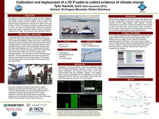
  • 1. Calibration and deployment of a 3D P-cable to collect evidence of climate change Tyler Hackett, MATE intern (summer 2015) Advisor: Dr.Gregory Mountain, Robert Steinhaus The objective of this project was to obtain acoustic images of the geologic record of climate change from the continental shelf 30km to 80km off the coastline of New Jersey. The research was conducted over a period of six weeks during the summer of 2015. Two seismic acquisition systems were used to collect the data, a three-kilometer hydrophone streamer which was used to accurately measure sound velocities to calibrate the P-Cable, which was the main acquisition system. • 235 Ft (71 m) • 55 personnel DEPLOYMENT / RECOVERY OBJECTIVE OPERATION RV Langseth SIESMIC SOURCE • 4 Bolt air guns • 700 in3 Total @ 2000 PSI P-CABLE SYSTEM • 24 streamers • 96 Hydrophones per streamer • 12.5 meters apart SET-UP Navigation of the entire seismic survey was completed using NCS Subsea technologies. Attached to each of the GPS buoys, paravanes, and seismic source was a GPS that communicated with the navigation software. This software gave a visual representation of the orientation of the seismic equipment and the area of the prospect where data was obtained as seen by the green on the map below. While obtaining data each individual on duty had a specific job. My main responsibility consisted of starting, monitoring, and shutting off the single steamer data collection. Another responsibility of mine was to observe the seismic source string to make sure there were not any issues. While monitoring I had to log any events along the line including start and end of line, any animal power-downs, or technical difficulties. The deployments of the seismic systems were unique. The single 3-km long off-set streamer was the first to be deployed. This included the streamer levelers also known as birds being attached to control the depth of the streamer as it was towed. To deploy the full P-Cable system, the single streamer had to be pulled to the port side. Then the starboard paravane and GPS buoy were deployed and the P-Cable quickly followed. After each short streamer was attached to the P-Cable, tests were performed to make sure the communication was operating properly. This continued until all 24 streamers were deployed. The port paravane and port GPS buoy were then deployed and spooled out to the final position. This process took every technician on shift to safely and efficiently deploy the entire system. My duties consisted of aiding the technicians in safely deploying the paravanes and GPS buoys. Later on in the cruise my duties shifted to the more responsible position of controlling the spare reel that held all of the P-Cable streamers. I was also able to get hands-on experience deploying and recovering the seismic source. All of these jobs required above average communication and focus. NAVIGATION P-CABLE SOFTWARE The P-Cable software that was developed by Geometrics was used to obtain the data only from the P-Cable system. This software gives an image of sound reflected off layered sediments below the sea floor. The real time data is used to observe if there are any other sounds being picked up that are not of our interest. These noises include ship noise, issues with the air source and other interferences. Below is an example of the software. The MATE Internship Program is funded by the REU program of the National Science Foundation’s Division of Ocean Sciences. Since 1999, the MATE internship program has placed over 300 students in at-sea internships lasting from two weeks to six months. More information about the program can be obtained at: http://www.marinetech.org/internships/