Power of Local Webinar: Kenya Flying Labs
•Télécharger en tant que PPTX, PDF•
1 j'aime•49 vues

Cleopa Otieno, Kenya Flying Labs Coordinator, presents his team members and shares some insights about their Flying Labs most recent projects such as Machakos County Mapping and their future activities. He also talks about Kenya’s government’s plan to adopt new drone regulations in the country which will facilitate the activities of Kenya Flying Labs. See the presentation: https://youtu.be/gPCxJDTc1Ok

Recommandé
Recommandé
Contenu connexe
Tendances
Tendances (20)
Similaire à Power of Local Webinar: Kenya Flying Labs
Similaire à Power of Local Webinar: Kenya Flying Labs (20)
Plus de WeRobotics
Plus de WeRobotics (20)
Dernier
Dernier (20)
Power of Local Webinar: Kenya Flying Labs
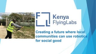
- 1. Creating a future where local communities can use robotics for social good
- 2. AidRobotics Address humanitarian needs for pre/post disaster response and management, policy and coordination with robotics solutions and data analytics HealthRobotics Identify low-cost ways that provide high- precision health care in remote area setting through cargo and mapping solutions that are locally managed and maintained EcoRobotics Support local commu- nities with sustainable farming practices, address nature conservation needs and plan for environ- mental impacts in areas affected by global warming using robotics solutions DevRobotics Address infrastructure issues with robotics solutions and data analytics and create local “Drones-as-a- Service” markets an ecosystems Sector-oriented Program Tracks
- 3. TEAM Drones for Humanity is registered in Kenya as a company with a mission of promoting use of civilian drones across sectors. KFL runs as a program under it. Cleopa Otieno Director/ Certified Pilot Harrison Juma Drone data Specialist (AI and ML) Anne Nderitu Aeronautical Engineer Sharon Telewa Telecommunicatio ns Engineer Sospeter Opondo Accountable Manager
- 4. Projects - FAO Kenya Drone Dialogue Joint workshop and demo session with FAO Kenya held in Machakos County to learn about use of drones in conservation and forest management.
- 7. Projects - Machakos County Mapping Mapping of Machakos Peoples Park, this was a demo to the county of Machakos on how they could use drones to create high resolution local maps.
- 8. Machakos County Governor, Dr. Alfred Mutua and FAO Kenya Director, Gabriel Rugalema
- 9. Projects - Machakos County Mapping 360 Panorama of the city and Machakos Peoples Park. (Web)
- 10. Projects - Jomo Kenyatta University of Agriculture and Technology (JKUAT) • MOU with the university • Capacity Support on drones • Support Masters and PHD students working with drones in their projects • Workshops and conferences on drones • AI and Machine Learning • Agriculture and Engineering
- 12. PROSPECTS Drone Data Management (AI & ML) – JKUAT 14th June Del Monte Kenya Limited - A Kenyan food processing company that operates in the cultivation, production, and canning of pineapple products. (13th June) UN-Habitat - initial meeting done on 6th June. Safaricom Ltd ICRC – Drones in Agriculture presentation on 26th June Drone Corridor – Partners UNICEF, WeRobotics, Machakos County.
- 13. Safaricom – Drones for Radio Applications; COW/Tethered Solution Deployment - Disasters - Vandalised Network Equipment - During crowded events
- 15. Drone Corridor
- 16. Drone Corridor
- 18. kenya@flyinglabs.org +254 720 950 220 Q & A
Notes de l'éditeur
- Examples: Social Good sector: Until today, only GIS-data available after disaster was satellite imagery. Satellite imagery is Untimely (very limited control on time-factor of data acquisition) Expensive Cannot be locally produced and controlled Private / industry sector: First clients of drone imagery were largely mining companies as they have an important need to calculate volume extractions in a timely matter (several measurements per year on very exact dates) and with high precision. Their alternative was using traditional civil-engineering/surveying methods (measurements using GPS information). Important time investment (for a quarry of approx. 600 hectares = 1 day of field work for 2 workers and 4 days of compiling data and create extraction volume) Expensive (expensive equipment for hard- and software / important human ressources) Dangerous/Hazardous: in many situation, the data acquisition in the field is in hazardous terrain, implicating important danger for the engineers Data acquisiton with drones will take approximately 2 hours Data processing & production of extraction volumes will take approximately 1 day Total of 1,5 days vs 5 days for traditional methods Cost of drone HW/SW (initial investment) is about half the price
- Examples: Social Good sector: Until today, only GIS-data available after disaster was satellite imagery. Satellite imagery is Untimely (very limited control on time-factor of data acquisition) Expensive Cannot be locally produced and controlled Private / industry sector: First clients of drone imagery were largely mining companies as they have an important need to calculate volume extractions in a timely matter (several measurements per year on very exact dates) and with high precision. Their alternative was using traditional civil-engineering/surveying methods (measurements using GPS information). Important time investment (for a quarry of approx. 600 hectares = 1 day of field work for 2 workers and 4 days of compiling data and create extraction volume) Expensive (expensive equipment for hard- and software / important human ressources) Dangerous/Hazardous: in many situation, the data acquisition in the field is in hazardous terrain, implicating important danger for the engineers Data acquisiton with drones will take approximately 2 hours Data processing & production of extraction volumes will take approximately 1 day Total of 1,5 days vs 5 days for traditional methods Cost of drone HW/SW (initial investment) is about half the price
- Examples: Social Good sector: Until today, only GIS-data available after disaster was satellite imagery. Satellite imagery is Untimely (very limited control on time-factor of data acquisition) Expensive Cannot be locally produced and controlled Private / industry sector: First clients of drone imagery were largely mining companies as they have an important need to calculate volume extractions in a timely matter (several measurements per year on very exact dates) and with high precision. Their alternative was using traditional civil-engineering/surveying methods (measurements using GPS information). Important time investment (for a quarry of approx. 600 hectares = 1 day of field work for 2 workers and 4 days of compiling data and create extraction volume) Expensive (expensive equipment for hard- and software / important human ressources) Dangerous/Hazardous: in many situation, the data acquisition in the field is in hazardous terrain, implicating important danger for the engineers Data acquisiton with drones will take approximately 2 hours Data processing & production of extraction volumes will take approximately 1 day Total of 1,5 days vs 5 days for traditional methods Cost of drone HW/SW (initial investment) is about half the price
- Examples: Social Good sector: Until today, only GIS-data available after disaster was satellite imagery. Satellite imagery is Untimely (very limited control on time-factor of data acquisition) Expensive Cannot be locally produced and controlled Private / industry sector: First clients of drone imagery were largely mining companies as they have an important need to calculate volume extractions in a timely matter (several measurements per year on very exact dates) and with high precision. Their alternative was using traditional civil-engineering/surveying methods (measurements using GPS information). Important time investment (for a quarry of approx. 600 hectares = 1 day of field work for 2 workers and 4 days of compiling data and create extraction volume) Expensive (expensive equipment for hard- and software / important human ressources) Dangerous/Hazardous: in many situation, the data acquisition in the field is in hazardous terrain, implicating important danger for the engineers Data acquisiton with drones will take approximately 2 hours Data processing & production of extraction volumes will take approximately 1 day Total of 1,5 days vs 5 days for traditional methods Cost of drone HW/SW (initial investment) is about half the price