SlideShare a Scribd company logo
1 of 36
Download to read offline
UNIT: 1
Hydrology is the study of water on and beneath the earth’s surface, with regards to its
occurrence, distribution, movement and properties as well as its relationship with the
environment within each phase of the water cycle.
This science has many important applications such as flood control, irrigation, domestic and
industrial water supply, and the generation of hydroelectric power.
Another similar term is hydrogeology, but don’t get confused between the two terms.
One major difference between hydrology and hydrogeology is that: While Hydrogeology
focuses only on the water flow and distribution below the earth’s surface, hydrology
studies water occurrence and movement on and beneath the earth’s surface.
Hydrology is the science that deals with all aspects of the water available on the earth. It
includes study of occurrence of water, its properties, its distribution and circulation and
also its effects on the living beings and their surroundings. It is not entirely a pure science
because it has many practical applications and it utilizes knowledge of other sciences
greatly.
The equation is: P = R + L or Precipitation = Runoff + Losses
In the above equation precipitation indicates total supply of water from all forms of falling
moisture and mainly includes rainfall and snowfall. The runoff represents surplus water
that flows over the surface to join some river or sea.
The term losses includes that portion of water which goes to atmosphere and underground
by the processes like evaporation and percolation respectively. For practical reasons
hydrology does not cover all studies- of oceans and medical uses of water.
After studying this equation with the background of hydrologic cycle it will be clear that the
term losses never implies that this water is lost and cannot be used again. It is the water
which temporarily disappears from view (e.g., evaporation, seepage, etc.) and given
favourable conditions, reappears to perform various duties. Hence, it is necessary to study
all the three terms of the equation, namely rainfall, runoff, and losses.
SCOPE OF HYDROLOGY
They are different aspects of hydrology. They include:
1. Study of water on and beneath the earth’s surface.
2. Study of water occurrence, distribution and movement.
3. Inspection of water properties.
4. Analyzing the interaction between water and the environment at different cycle
phases.
1. Study of water on and beneath the earth surface
• Water is central to most natural processes. It transports sediment and solutes to
lakes and oceans, thereby shaping the landscape.
• Hydrologic science has an important place in the field of water resources, especially
freshwater resources, which are the subject of intense concern and study.
• Water exists on the earth’s surface as surface water.
• This includes both the saltwater in the ocean and the freshwater in rivers, streams,
and lakes.
• Surface water is an important source of drinking water and is used for the irrigation
of farmland.
• Water exists below the earth’s surface as groundwater.
• Groundwater is the water present beneath Earth’s surface in soil pore spaces,
underground bedrocks and in the fractures of rock formations.
• Groundwater moves slowly through underground rock layers called aquifers and
accounts for approximately 30% of fresh water on earth.
• Surface water and groundwater are reservoirs that can feed into each other.
• Surface water can seep underground to become groundwater, groundwater can also
resurface on land to replenish surface water.
2. Study of water occurrence, distribution and movement
• Water circulates throughout the Earth through different pathways and at different
rates.
• Hydrology is concerned with the continuous circulation of water in the air-
atmosphere system, the hydrologic cycle.
• The hydrologic cycle describes how water evaporates from the surface of the earth,
rises to the atmosphere, cools and condenses into rain or snow in clouds, and falls
again to the surface as precipitation.
• Water takes on various forms in the environment in response to changes in
temperature and other influences.
• It also exists in various quantities and quality as it moves through the cycle.
• Water content trapped by trees and plants also returns back to the atmosphere
through transpiration or in a more general phase called evapotranspiration.
• Parts of hydrology involves developing methods for directly measuring these flows or
amounts of water available as well as modelling these processes either for scientific
knowledge or for making a prediction in practical applications.
3. Inspection of water properties
• Hydrology also deals with the physical and chemical properties of water in all its
phases.
• Different phase exhibits different water properties and this affects water usage.
• As a result of thermal content, the kinetic energy of water varies in different states
resulting in varying water properties.
• The temperature, turbidity, pH levels, taste, and many more properties are key
factors of a hydrologic datasheet.
4. Analyzing the interaction between water and the environment at different cycle
phases
• Apart from studying the natural distribution and movement of water, hydrology is
also concerned with the impact of human activities on water quality as well as water
management problems.
• A change in water quality or quantity can affect the local environment positively or
otherwise.
• These changes can be: man-made (e.g. a dam release); weather-related (flooding), or
a combination of both factors (i.e. rainfall-runoff caused by poor agricultural
practices).
• Regardless of the cause, hydrologic data assists in explaining water quality and
environmental changes.
Importance of water
Water is one of the most important resources on the planet. Without water, life cannot
exist. But what makes water so important? Water has several unique characteristics that
make it an extremely valuable resource. Some such properties of water are listed below.
Water is a very good solvent – it has the ability to dissolve many substances.
The boiling point and freezing point of water make it easily available in all three states
(solid, liquid, and gaseous).
The specific heat of water is quite high. This enables water to absorb and release heat
slowly, thereby regulating the temperature of its environment.
Owing to its transparency, water can allow light to reach the life forms that are submerged
in it. This is crucial for the survival of plant life in the oceans, lakes, and rivers.
Water is neither acidic nor basic in nature. It has a pH of 7, making it a neutral substance.
These unique qualities of water, along with its abundance on the planet (approximately
71% of the Earth’s surface is made up of water), make it a crucial resource for plants,
animals, and human beings.
Importance of Water in Living Organisms
• Water is the medium through which all essential vitamins and minerals are
transported in the bodies of living organisms (owing to its ability to dissolve a wide
range of substances).
• Water also plays a vital role in facilitating the work of enzymes in living organisms.
For example, the sodium bicarbonate secreted by the pancreas is broken down into
ions by water, making the medium sufficiently alkaline for the enzymes to work.
• Water helps maintain body temperatures in plants and animals. In order to decrease
the temperature in their bodies, animals lose water via perspiration (sweating) and
plants lose water via transpiration.
• Since water can rise in capillary tubes without any external help, it can be
transported from the roots of trees to every other part of the tree.
• Water is an integral part of photosynthesis. Without it, autotrophic plants would not
be able to produce their own food.
• Water serves as a habitat for more than 50% of all life on Earth.
Importance of Water in Human Beings
• Insufficient water content in the human body results in severe dehydration, which is
often accompanied by kidney failure, seizures, and swelling in the brain.
• Water helps improve the circulation of oxygen throughout the body.
• It also plays a crucial role in the digestion of food.
• Water is a very important component of saliva, which helps break down food.
• The excretion of waste in the human body requires water. Insufficient water levels in
the body may increase the strain on the kidneys, resulting in the formation of kidney
stones.
Other Important Uses of Water
• If not for the high specific heat of water, the temperature of the Earth’s surface
would be much lower. This would make it difficult for life to survive.
• The water in the Earth’s oceans absorb heat from the sun during the day and help
maintain the temperature during the night.
• Water is necessary for the irrigation of crops and is, therefore, an integral part of
agriculture.
• It is widely used in cooking activities since it boils at a temperature of 100o
• Humans make use of water for a wide range of domestic activities such as washing
and cleaning.
• Water also serves as a medium for the transportation of cargo. Many goods are
transported between the Earth’s continents via ships.
Industrial Uses of Water
• Many industries require large quantities of water for processing, cooling, and diluting
products. Examples of industries that consume large quantities of water include the
paper industry, the food industry, and the chemical industry.
• Water is also used as an industrial solvent for the production of several commercially
important products. Almost all power plants that generate electricity employ water
to spin turbines.
• Heavy water, an important form of water, is widely used in nuclear reactors as a
neutron moderator.
Hydrological Cycle:
• Hydrological cycle is also known as “water cycle” and there is a continuous exchange
of water between the atmosphere, the oceans and the continents through the
processes of evaporation, transpiration, condensation and precipitation. As the
moisture which is present in the atmosphere is taken from water bodies through a
process called evaporation and from plants through a process called transpiration
(evapotranspiration). Further this evaporation undergoes condensation for the
formation of clouds and once after the formation of clouds they fall down in the
form of raindrops through precipitation process.
• As the total amount of water vapour present in the atmosphere is constant, to
maintain this there should be a proper balance between evapotranspiration and
precipitation. And the cycle which maintains this stability is the Hydrological cycle.
• This cycle does not have any starting and ending point, as it leads to continuous
circulation of water present on the Earth which causes evolution of the Earth. The
factor that assists hydrological cycle or water cycle is the sun, air currents to name a
few.
Process of the Water Cycle
Water cycle is completed in various stages or process they are:
1. Stage I: Evaporation and Transpiration:
• In this process energy from the sun heats up the lakes, rivers, oceans, swamps and
other water bodies which subsequently increase the temperature of the water
present in them. This leads to evaporation of some water into air and the rising air
current takes the vapour up in the sky.
• Along with this process at the same time plants and trees also lose water to the
atmosphere in the form of vapour which rises up in the sky.
2. Stage II: Condensation
• In this process the vapour which rises up gets cooled because of cooler temperature
in the surrounding. Because of this water vapour turns back into liquid through the
condensation process.
3. Stage III: Precipitation
• In this process there occurs collisions in the cloud particles because of wind
movements. Because of this clouds become water laden and they develop into rain
bearing clouds and fall back onto the earth’s surface by the process known as
precipitation.
• They may fall on the Earth in the form of rain, hail, snow or sleet depending upon the
temperature conditions.
4. Stage IV: Runoff and Infiltration
• After the precipitation process, precipitated water runs off into oceans, rivers and
ground surface or is absorbed into the soil (infiltration).
• After going through all these steps water is again ready to go through evaporation
and resume earlier stages.
• By going through all these processes of hydrological cycle or water cycle water is
bringed back to people in the form of fresh water.
Water Storage
Water storage is a broad term referring to storage of both potable water for consumption,
and non potable water for use in agriculture. In both developing countries and some
developed countries found in tropical climates, there is a need to store potable drinking
water during the dry season. In agriculture water storage, water is stored for later use in
natural water sources, such as groundwater aquifers, soil water, natural wetlands, and
small artificial ponds, tanks and reservoirs behind major dams. Storing water invites a host
of potential issues regardless of that waters intended purpose, including contamination
through organic and inorganic means.
Types
1. Groundwater
• Groundwater is located beneath the ground surface in soil pore spaces and in the
fractures of rock formations. A unit of rock or an unconsolidated deposit is called an
aquifer when it can yield a usable quantity of water. The depth at which soil pore
spaces or fractures and voids in rock become completely saturated with water is
called the water table. There are two broad types of aquifers: An unconfined aquifer
is where the surface is not restricted by impervious rocks, so the water table is at
atmospheric pressure. In a confined aquifer, the upper surface of water is overlain by
a layer of impervious rock, so the groundwater is stored under pressure.
• Aquifers receive water through two ways, one from precipitation that that flows
through the unsaturated zone of the soil profile, and two from lakes and rivers.
When a water table reaches capacity, or all soil is completely saturated, the water
table meets the surface of the ground where water discharge in the forms of springs
or seeps.
• It is also possible to artificially recharge aquifers (using wells), for example through
the use of Aquifer storage and recovery (ASR).
2. Soil moisture
• Groundwater is stored in two zones, one being the saturated zone, or Aquifer, the
other is the pore space of unsaturated soil immediately below the ground surface.
Soil moisture is the water held between soil particles in the root zone (rhizosphere)
of plants, generally in the top 200 cm of soil. Water storage in the soil profile is
extremely important for agriculture, especially in locations that rely on rainfall for
cultivating plants. For example, in Africa rain-fed agriculture accounts for 95% of
farmed land.
3. Wetlands
• Wetlands span the surface/sub-surface interface, storing water at various times as
groundwater, soil moisture and surface water. They are vital ecosystems that
support wildlife and perform valuable ecosystem services, such as flood protection
and water cleansing. They also provide livelihoods for millions of people who live
within and around them. For example, the Inner Niger River Delta in the Western
Sahel zone supports more than a million people who make their living as fishermen,
cattle breeders or farmers, using the annual rise and fall of the river waters and its
floodplains.
• Wetlands are basically sponges that capture and slowly release large amounts of
rain, snowmelt, groundwater and floodwater. Trees and other wetlands vegetation
slow the speed of flood water and more evenly distribute it across the wetland. The
combination of increased water storage and flood water hindrances lower flood
heights and reduce erosion.
4. Ponds and tanks
• Detention basins and water tanks can be defined as community-built and household
water stores, filled by rainwater, groundwater infiltration or surface runoff. They are
usually open, and therefore exposed to high levels of evaporation. They can be a
great help to farmers in helping them overcome dry spells. However, they can
promote vector-borne diseases such as malaria or schistosomiasis.
• Detention basins are designed for temporary capture of flood waters and do not
allow for permanent pooling of water and therefore do not make viable or reliable
sources of water storage. Retention basins are similar to detention basins for flood
control management, but are built for permanent pooling to control sediment and
pollutants in the flood water.
5. Dams and reservoirs
• In the past, large dams have often been the focus of water storage efforts. Many
large dams and their reservoirs have brought significant social and economic
benefits. For example, Egypt's Aswan High Dam, built in the 1960s, has protected the
nation from drought and floods and supplies water used to irrigate some 15 million
hectares. However, dams can also have great negative impacts. Because sediment is
trapped by the Aswan High Dam, the Nile no longer delivers nutrients in large
quantities to the floodplain. This has reduced soil fertility and increased the need for
fertilizer.[9] Water stored in dams and reservoirs can be treated for drinking water,
but in the past due to poor taxing and high water prices in the US, water supply dams
are unable to reach their intended levels of operation.[10] Due to the increased
surface area of water that dams create, huge amounts of water is lost to
evaporation, much more so than what would have been lost from the river that
flowed in its place.
UNIT: 2
Surface water is water located on top of the Earth's surface, and may also be referred to as
blue water. In common usage, it is usually used specifically for terrestrial (inland)
waterbodies, the vast majority of which is produced by precipitation and runoff from
nearby higher areas.
• As the climate warms in the spring, snowmelt runs off towards nearby streams and
rivers contributing towards a large portion of human drinking water. Levels of
surface water lessen as a result of evaporation as well as water moving into the
ground becoming ground-water.
• Alongside being used for drinking water, surface water is also used for irrigation,
wastewater treatment, livestock, industrial uses, hydropower, and recreation. For
USGS water-use reports, surface water is considered freshwater when it contains less
than 1,000 milligrams per liter (mg/L) of dissolved solids.
• There are three major types of surface water. Permanent (perennial) surface waters
are present year round, and includes lakes, rivers and wetlands (marshes and
swamps). Semi-permanent (ephemeral) surface water refers to bodies of water that
are only present at certain times of the year including seasonally dry channels such
as creeks, lagoons and waterholes. Man-made surface water is water that can be
continued by infrastructures that humans have assembled. This would be dammed
artificial lakes, canals and artificial ponds (e.g. garden ponds) or swamps. The
surface water held by dams can be used for renewable energy in the form of
hydropower. Hydropower is the forcing of surface water sourced from rivers and
streams to produce energy.
FACTOR AFFECTING QUANTITY
• Land use
• Soil type
• Geology
• Vegetation
• Slope
• Climate
FACTOR AFFECTING QUALITY
• Sedimentation
• Runoff
• Erosion
• Dissolved oxygen
• pH
• Temperature
• Decayed organic materials
• Pesticides
• Toxic and hazardous substances
• Oils, grease, and other chemicals
• Detergents
• Litter and rubbish
Precipitation is any form of moisture which falls to the earth. This includes rain, snow, hail
and sleet.
• Precipitation occurs when water vapour cools. When the air reaches saturation point
(also known as condensation point and dew point) the water vapour condenses and
forms tiny droplets of water. These tiny droplets of water from clouds.
• Complex forces cause the water droplets to fall as rainfall.
• All rain is the same. It happens as the result of warm, moist air being cooled, leading
to condensation and in turn rain. The following examples show three different ways
air is cooled causing rainfall.
Forms of precipitation
1. Rain:
• Rain in the form of precipitation occurs in the form of water drops.
• These water drops are of a size larger than 0.5mm. The maximum size of the
raindrop is approximately 6mm.
• In case, the droplets are larger than 6mm, they break down into smaller droplets and
fall on the earth.
• Rainfall is an essential form of precipitation that contributes significantly to the water
resources of the earth as well as an important constituent of the ecological cycle.
• The magnitude of rainfall even indicates the high temporal and spatial variation.
Such variations are responsible for the occurrence of various extreme hydrological
conditions such as floods, famines and droughts.
2. Snow:
• Snow is the form of precipitation that consists of crystals of ice in a flaky form.
• It usually has an average density of 0.1gm/cc.
• Snow is also a chief contributor to the water resources of the earth.
3. Drizzle:
• It is the form of precipitation that is similar to rain.
• However, the drizzle consists of water droplets with a size of less than 0.5mm.
4. Sleet:
• Sleet is the form of precipitation that exists in the form of frozen droplets of rain.
• The freezing of the droplets mostly occurs when the droplets pass through the air at
freezing temperatures.
5. Glaze:
• The glaze is also commonly referred to as freezing rain.
• It is the form of precipitation that is formed when the rain or drizzle comes in contact
with the cold ground usually at 0 degrees Celsius.
6. Hail:
• Hail is the form of precipitation that exists in the form of lumps or pellets with a size
greater than 8mm.
Types of Precipitation
1. Cyclonic Precipitation
• Cyclonic precipitation generally refers to the precipitation that occurs by the cyclonic
movement or action of the moist mass of air.
• A cyclone is a phenomenon that occurs in the atmosphere consisting of low pressure
and circular wind motion. Thus, cyclonic precipitation is the type of precipitation that
occurs due to such cyclonic action with the aid of the pressure difference.
The cyclonic precipitation can be classified into the following:
• Frontal
It is the hot moist air mass boundary that occurs due to the expansion of air near the
frontal surface.
• Non-Frontal
It is a cold air mass boundary that occurs due to the movement of the cold mass of
moist air that results in precipitation.
2. Convective Precipitation
• Convective precipitation is the type of precipitation that results from the convective
movement of the air.
• In actuality, the air present above the surface of land gets heated and this warmer air
being lighter moves up, cools down and thus precipitates.
• The convective precipitation mostly occurs in varying intensities and in the form of
showers.
• The areal extent of such precipitation is relatively smaller and usually is in the range
of less than 10km in diameter.
3. Orographic Precipitation
• Orographic precipitation is the type of precipitation that occurs by the orographic
action i.e. the movement of the moist mass of air in the windward side of the
mountain.
• In other words, moving air masses have chances to strike barriers like mountains.
Once they strike, they rise which causes condensation and precipitation.
• The precipitation is greater on the windward side of the barrier compared to the
leeward side of the barrier.
Causes of Precipitation
1. Frontal Activity
• Frontal precipitation occurs as a consequence of slow ascent of air in synoptic
systems (on the order of cm/s), such as over surface cold fronts, and over and
ahead of warm fronts.
• A similar ascent is seen around tropical cyclones outside of the eyewall and in
comma-head precipitation patterns around mid-latitude cyclones.
• It is also called stratiform or dynamic precipitation.
2. Convection
• It is the most common cause of precipitation in tropical areas.
• Convectional clouds fall as showers with rapidly changing intensity.
• Convective precipitation falls over a certain area for a relatively short time, as
convective clouds have a limited horizontal extent.
• It is also called showery precipitation
3. Orographic Action
• Orographic precipitation occurs on the windward (upwind) side of mountains and
is caused by the rising air motion of a large-scale flow of moist air across the
mountain ridge, resulting in adiabatic cooling and condensation.
Factors of precipitation
1. Moisture supply: A rule of thumb is that when the relative humidity reaches or
exceeds 70% at 850 mb (around 1,500 meters or 5,000 ft. above sea level), overcast
conditions are usually observed, and when relative humidity reaches 90% or more,
then precipitation often occurs. We will define an intermediate value of relative
humidity, 80%, to be "favorable" for precipitation.
2. Frontal Position: To decide whether or not a front is close enough to be "favorable"
for precipitation at our forecast location, we define a circular region centered on our
forecast location with a radius of 140 miles (about 2° of latitude). (See a map
showing this frontal influence region used for scoring purposes.) If a front of any type
is reported within this area during the 24 hour period between 12Z and 12Z, we
define it to be a factor favoring precipitation. You can use the NWS forecast frontal
positions to help you with this.
3. Unstable Atmosphere: An unstable atmosphere is one that favors unassisted or
unforced, buoyant, upward air motion, which can lead to cumulonimbus clouds.
Interception refers to precipitation that does not reach the soil, but is instead intercepted
by the leaves, branches of plants and the forest floor. It occurs in the canopy (i.e. canopy
interception), and in the forest floor or litter layer (i.e. forest floor interception). Because of
evaporation, interception of liquid water generally leads to loss of that precipitation for the
drainage basin, except for cases such as fog interception, but increase flood protection
dramatically, Alila et al., (2009).
• Interception deals with the amount of water that is caught and stored on the
leaves and stems of vegetation. The term vegetation includes forest tree cover,
crops and low level vegetation like under-bush, grass etc. Part of the precipitation
which falls either as rainfall or snowfall is caught by vegetative cover before it
reaches ground.
• This is a matter of common experience when the people take shelter below a tree
during rainfall. The rain drops or snowflakes are retained by the leaves as droplets
or thin layers on their surface or in the depression of the leaves.Factors
Factors affecting interception
(i) Type of Vegetation:
• Interception varies with the species, its age and density of stands. About 10 to 20%
of precipitation occurring in the growing season is intercepted. It is lost substantially
by way of evaporation from leaves. In dense tall vegetation interception is quite
substantial.
• So interception by low-lying vegetation is usually negligible for hydrologic studies.
But if such vegetation cover exists below the forest canopy it affects runoff
substantially. Dense grasses and herbs approaching full growth intercept as much
precipitation as forest cover. However, since their season is short total amount
intercepted is considerably less than the forest cover.
(ii) Wind Velocity:
• If the wind accompanies the precipitation the leaves become incapable of holding
much water as compared with the still air condition. On the other hand due to
blowing of wind the evaporation rate also increases. It is thus seen that during short
storm interception decreases but during long storm interception is augmented due
to increased evaporation.
(iii) Duration of Storm:
• Interception storage is filled up in the first part of a rain storm. Therefore, if yearly
precipitation is made up of several small duration storms separated by dry spells
evaporation will be high and interception will be consequently more. However, if
storms of long duration occur and if weather remains cloudy, relatively interception
loss will be less.
(iv) Intensity of Storm:
• When precipitation occurs in still air conditions with low intensity interception will be
more. On the contrary if rain drops come with great speed their impact dislodges
intercepted drops and leaves cannot hold much water.
(v) Season of the Year:
• During summer or dry season the interception rate is quite high because of high
evaporation. Summer interception is 2 to 3 times more than the winter season
interception.
(vi) Climate of the Area:
• In arid and semiarid regions due to prevailing dry conditions the interception loss is
more than that occurring in humid regions.
Surface run-off
• Runoff, in hydrology, quantity of water discharged in surface streams. Runoff
includes not only the waters that travel over the land surface and through channels
to reach a stream but also interflow, the water that infiltrates the soil surface and
travels by means of gravity toward a stream channel (always above the main
groundwater level) and eventually empties into the channel.
• Runoff also includes groundwater that is discharged into a stream; streamflow that is
composed entirely of groundwater is termed base flow, or fair-weather runoff, and it
occurs where a stream channel intersects the water table.
• The total runoff is equal to the total precipitation less the losses caused by
evapotranspiration (loss to the atmosphere from soil surfaces and plant leaves),
storage (as in temporary ponds), and other such abstractions.
Sources of Surface run-off
• Excess rainwater
• Stormwater
• Meltwater
Factors affecting runoff
Meteorological factors affecting runoff:
• Type of precipitation (rain, snow, sleet, etc.)
• Rainfall intensity
• Rainfall amount
• Rainfall duration
• Distribution of rainfall over the drainage basin
• Direction of storm movement
• Precipitation that occurred earlier and resulting soil moisture
• Other meteorological and climatic conditions that affect evapotranspiration, such as
temperature, wind, relative humidity, and season
Physical characteristics affecting runoff:
• Land use
• Vegetation
• Soil type
• Drainage area
• Basin shape
• Elevation
• Topography, especially the slope of the land
• Drainage network patterns
• Ponds, lakes, reservoirs, sinks, etc. in the basin, which prevent or delay runoff from
continuing downstream
Evaporation is a process by which water is transformed from liquid to a gaseous state. Heat
is the main cause of evaporation. The temperature at which the water starts evaporating is
referred to as the latent heat of vapourisation.
An increase in temperature increases the water absorption and retention capacity of the
given parcel of air. Similarly, if the moisture content is low, the air has the potentiality of
absorbing and retain moisture. The movement of air replaces the saturated layer with the
unsaturated layer. Hence, the greater the movement of air, the greater is the evaporation.
Measurement of evaporation
• Theoretically speaking, evaporation can be measured on the basis of rate of
vaporization over any water level. This is possible only in laboratories. This function is
very difficult in open water area because nature cannot be controlled so minutely.
John Dalton discovered the ‘Rule of Partial Pressure’ in 1801. He tried to measure
evaporation indirectly by measuring air on water level and pressure of vapour by
using an equation which was later on revised by many researchers. His method is
called ‘Mass Transfer Method’ of measuring evapo­ration.
• As per one estimate, 4, 55,000 cubic kms water from the sea reach’s in the
atmosphere every year through evaporation. Similarly, 62,000 cubic kms reaches the
atmosphere through evaporation from water sources situated on the earth. As
against it, when 98,000 cubic kms water through evaporation enters into the
atmosphere, it is absorbed in it.
• Water vapour can be absorbed in atmosphere in a definite quantity. As soon as the
relative humidity becomes 100 per cent, air is called saturated. It has been seen that
hardly one per cent of the total water available on earth is used by the hydrological
cycle. It normally believed that nowhere is there equality between evaporation and
precipitation.
• As estimated by M. I. Budyoko (1971), evaporation from oceans is more than rain.
According to him, loss of 46,000 cubic kms water takes place from oceans every year.
On the other side, 62,000 cubic kms water evaporates every year from the land, but
It receives 1, 08,000 cubic kms water through rain. Hence, the land receives 46,000
cubic kms additional water every year. Such additional water again reaches oceans
through surface flow. Thus, more rain is received by continents as compared to
evaporation.
Evapotranspiration (or "ET") is the water lost through plant transpiration and soil and
plant evaporation. The images below help explain what ET is and how it occurs.
•
• Evapotranspiration (ET) is the combination of evaporation and transpiration.
Evaporation is water movement from wet soil and leaf surfaces. Transpiration is
water movement through the plant. This water movement helps move vital nutrients
through the plant.
• Evapotranspiration (ET) is an energy-driven process. ET increases with temperature,
solar radiation, and wind. ET decreases with increasing humidity.
Atmospheric factors affecting transpiration
The amount of water that plants transpire varies greatly geographically and over time.
There are a number of factors that determine transpiration rates:
• Temperature: Transpiration rates go up as the temperature goes up, especially
during the growing season, when the air is warmer due to stronger sunlight and
warmer air masses. Higher temperatures cause the plant cells which control the
openings (stoma) where water is released to the atmosphere to open, whereas
colder temperatures cause the openings to close.
• Relative humidity: As the relative humidity of the air surrounding the plant rises the
transpiration rate falls. It is easier for water to evaporate into dryer air than into
more saturated air.
• Wind and air movement: Increased movement of the air around a plant will result in
a higher transpiration rate. Wind will move the air around, with the result that the
more saturated air close to the leaf is replaced by drier air.
• Soil-moisture availability: When moisture is lacking, plants can begin to senesce
(premature aging, which can result in leaf loss) and transpire less water.
• Type of plant: Plants transpire water at different rates. Some plants which grow in
arid regions, such as cacti and succulents, conserve precious water by transpiring less
water than other plants.
Controlling factors
• Energy availability. The more energy available, the greater the rate of
evapotranspiration. It takes about 600 calories of heat energy to change 1 gram of
liquid water into a gas.
• The humidity gradient away from the surface. The rate and quantity of water vapor
entering into the atmosphere both become higher in drier air.
• The wind speed immediately above the surface. The process of evapotranspiration
moves water vapor from ground or water surfaces to an adjacent shallow layer that
is only a few centimeters thick. When this layer becomes saturated
evapotranspiration stops. However, wind can remove this layer replacing it with drier
air which increases the potential for evapotranspiration. Winds also affect
evapotranspiration by bringing heat energy into an area. A 5-mile-per-hour wind will
increase still-air evapotranspiration by 20 percent; a 15-mile-per-hour wind will
increase still-air evapotranspiration by 50 percent.
• Water availability. Evapotranspiration cannot occur if water is not available.
• Physical attributes of the vegetation. Such factors as vegetative cover,plant height,
leaf area index and leaf shape and the reflectivity of plant surfaces can affect rates of
evapotranspiration. For example coniferous forests and alfalfa fields reflect only
about 25 percent of solar energy, thus retaining substantial thermal energy to
promote transpiration; in contrast, deserts reflect as much as 50 percent of the solar
energy, depending on the density of vegetation.
• [Stomatal resistance]. Plants regulate transpiration through adjustment of small
openings in the leaves called stomata. As stomata close, the resistance of the leaf to
loss of water vapor increases, decreasing to the diffusion of water vapor from plant
to the atmosphere.
• Soil characteristics. Soil characteristics that can affect evapotranspiration include its
heat capacity, and soil chemistry and albedo.
Unit 3:
Groundwater
• Groundwater is used for drinking water by more than 50 percent of the people in the
United States, including almost everyone who lives in rural areas. The largest use for
groundwater is to irrigate crops.
• Aquifers are typically made up of gravel, sand, sandstone, or fractured rock, like
limestone. Water can move through these materials because they have large
connected spaces that make them permeable. The speed at which groundwater
flows depends on the size of the spaces in the soil or rock and how well the spaces
are connected.
• Groundwater can be found almost everywhere. The water table may be deep or
shallow; and may rise or fall depending on many factors. Heavy rains or melting snow
may cause the water table to rise, or heavy pumping of groundwater supplies may
cause the water table to fall.
• Groundwater supplies are replenished, or recharged, by rain and snow melt that
seeps down into the cracks and crevices beneath the land's surface. In some areas of
the world, people face serious water shortages because groundwater is used faster
than it is naturally replenished. In other areas groundwater is polluted by human
activities.
• Water in aquifers is brought to the surface naturally through a spring or can be
discharged into lakes and streams. Groundwater can also be extracted through a well
drilled into the aquifer. A well is a pipe in the ground that fills with groundwater. This
water can be brought to the surface by a pump. Shallow wells may go dry if the
water table falls below the bottom of the well. Some wells, called artesian wells, do
not need a pump because of natural pressures that force the water up and out of the
well.
• In areas where material above the aquifer is permeable, pollutants can readily sink
into groundwater supplies. Groundwater can be polluted by landfills, septic tanks,
leaky underground gas tanks, and from overuse of fertilizers and pesticides. If
groundwater becomes polluted, it will no longer be safe to drink.
Stream flow
Streamflow, or channel runoff, is the flow of water in streams, rivers, and other channels,
and is a major element of the water cycle. It is one component of the runoff of water from
the land to waterbodies, the other component being surface runoff. Water flowing in
channels comes from surface runoff from adjacent hillslopes, from groundwater flow out of
the ground, and from water discharged from pipes. The discharge of water flowing in a
channel is measured using stream gauges or can be estimated by the Manning equation.
The record of flow over time is called a hydrograph. Flooding occurs when the volume of
water exceeds the capacity of the channel.
Streamflow characteristics offer some of the most appropriate and useful indicators for
assessing watershed health. They are extremely sensitive to human activities and reflect
weather and climate conditions, vegetation and soil type, land characteristics, and
human use. Common human activities, such as increasing the number of roads and parking
lots, change the timing and strength of runoff events resulting in "flashy" systems. Such
hydrologic variation shapes the biotic diversity within stream ecosystems by controlling
critical habitat conditions.
Characteristic of stream flow
1. Rainfall characteristics
• Magnitude intensity
• Distribution according to time and's pace.
• Variability.
2. Catchment characteristics
• Soil
• Vegetation
• Slope, geology, shape
• Drainage basin
3. Climatic factor
Type of stream
• Perennial
o Always carry some flow (all over year)
o Groundwater flow throughout the year
o Flow above bed of stream (dry season)
• Intermittent
o Groundwater (limited contribution)
o No groundwater during dry season.
o Dependable flow 0
• Ephemeral
o No base flow contribution.
o Water available during rainy seasons.
o Dry in dry season
Darcy law’s
• In 1856, french hydraulic engineer Henry Darcy published a report on the water
supply of the city of Dijon in France. In that report, Darcy described the result of an
experiment designed to study the flow of water through a porous medium.
• Darcy’s experiment resulted in the formulation of mathematical law that describes
fluid motion in porous media.
• Darcy’s law states that the rate of fluid flow through porous medium is proportional
to the potential energy gradient within that fluid. The constant of proportionality is
the Darcy’s permeability of soil.
• Darcy’s permeability is a property of both porous medium and the fluid moving
through the porous medium. In fact, Darcy’s law is the empirical equivalent of the
Navier-Strokes equation.
• Darcy’s flow velocity for laminar flow is defined as the quantity of fluid flow along the
hydraulic gradient per unit cross sectional area. Velocity of flow through a porous
media is directly proportional to the hydraulic gradient responsible for flow.
Here,
• V = discharge velocity or superficial velocity
• k = coefficient of permeability or hydraulic conductivity
• i = hydraulic gradient
• = fall in total head
• L = length of soil specimen
Assumptions of Darcy’s Law
• Soil is fully saturated.
• Temperature during testing is 27°C.
• Flow through soil is laminar
• Entire cross-sectional area is available for flow
• Flow is continuous and steady.
Validity of Darcy’s Law
Darcy’s law is valid only for slow and viscous flow, fortunately most groundwater flow cases
fall in this category. Typically, any flow with a Reynolds number less than 1 is clearly
laminar and it would be valid to apply Darcy’s law. Experimental tests have shown that flow
regimes with values of Reynolds number upto 10 may still be Darcine.
Permeability
• The ability of soil to allow flow of water through it is called as permeability of soil. It
is very important factor for the structures which are in contact with water.
• Flow of water in soil takes place through void spaces, which are interconnected.
Water does not flow in a straight line, but in a winding path. However in soil
mechanics flow is considered to be in a straight line at an effective velocity.
• The velocity of flow depends on size of pores.
Importance of Permeability of Soil
• Permeability influences the rate of settlement of a saturated soil under load.
• The stability of slopes and retaining structures can be greatly affected by
the permeability involved.
• The design of earth dams is very much based upon the permeability of soil used.
• Filters made of soils are designed based upon their permeability.
Properties of Permeability of Soil
• Solving problems involving pumping seepage water from construction excavation.
• Estimating the quantity of underground seepage.
• Stability analysis of earth structures and earth retaining walls subjected to seepage
forces.
Factors Affecting Permeability of Soil
• Grain size or Particle size
The above equation is given by Alan Hazen. Permeability depends on shape and soil of soil
particles.Permeability varies with square of particle size diameter.
• Void Ratio
If the presence of voids is more then the permeability is also more.
• Composition
For gravels, sand and silts presence of mica can decrease the permeability of soil. For clay,
water attracted between clay particles reduces the permeability.
• Structural Arrangement
Remolding of natural soil reduces permeability. If soil contains more rounded particles, the
permeability is more.
• Stratification
When flow of water is parallel to strata, permeability will be more when compared with
flow perpendicular to strata.
• Presence of foreign particles and entrapped air
This affects the permeability as it reduces void space and it blocks the inter-connectivity
between the pores.
• Degree of saturation
If the soil is dry or partly saturated the permeability of soil is always less.
Permeability Range of Different Soil Mass
• Gravel – cm/s
• Sand – – cm/s
• Silt – – cm/s
• Clay – – cm/s
Infiltration
• Infiltration is the process by which water on the ground surface enters the soil. It is
commonly used in both hydrology and soil sciences. The infiltration capacity is
defined as the maximum rate of infiltration. It is most often measured in meters per
day but can also be measured in other units of distance over time if necessary.
• The infiltration capacity decreases as the soil moisture content of soils surface layers
increases. If the precipitation rate exceeds the infiltration rate, runoff will usually
occur unless there is some physical barrier.
• Infiltrometers, permeameters and rainfall simulators are all devices that can be used
to measure infiltration rates.
• Infiltration is caused by multiple factors including; gravity, capillary forces,
adsorption and osmosis. Many soil characteristics can also play a role in determining
the rate at which infiltration occurs.
Factors that affect infiltration
1. Precipitation
• Precipitation can impact infiltration in many ways. The amount, type and duration of
precipitation all have an impact. Rainfall leads to faster infiltration rates than any
other precipitation events, such as snow or sleet.
• In terms of amount, the more precipitation that occurs, the more infiltration will
occur until the ground reaches saturation, at which point the infiltration capacity is
reached. Duration of rainfall impacts the infiltration capacity as well.
• Initially when the precipitation event first starts the infiltration is occurring rapidly as
the soil is unsaturated, but as time continues the infiltration rate slows as the soil
becomes more saturated. This relationship between rainfall and infiltration capacity
also determines how much runoff will occur. If rainfall occurs at a rate faster than the
infiltration capacity runoff will occur.
2. Soil characteristics
• The porosity of soils is critical in determining the infiltration capacity. Soils that have
smaller pore sizes, such as clay, have lower infiltration capacity and slower
infiltration rates than soils that have large pore size, such as sands. One exception to
this rule is when clay is present in dry conditions. In this case, the soil can develop
large cracks which leads to higher infiltration capacity.
• Soil compaction also impacts infiltration capacity. Compaction of soils results in
decreased porosity within the soils, which decreases infiltration capacity.
• Hydrophobic soils can develop after wildfires have happened, which can greatly
diminish or completely prevent infiltration from occurring.
3. Soil moisture content
• Soil that is already saturated has no more capacity to hold more water, therefore
infiltration capacity has been reached and the rate cannot increase past this point.
This leads to much more surface runoff. When soil is partially saturated then
infiltration can occur at a moderate rate and fully unsaturated soils have the highest
infiltration capacity.
4. Organic materials in soils
• Organic materials in the soil (including plants and animals) all increase the infiltration
capacity. Vegetation contains roots that extend into the soil which create cracks and
fissures in the soil, allowing for more rapid infiltration and increased capacity.
• Vegetation can also reduce surface compaction of the soil which again allows for
increased infiltration. When no vegetation is present infiltration rates can be very
low, which can lead to excessive runoff and increased erosion levels.[3] Similarly to
vegetation, animals that burrow in the soil also create cracks in the soil structure.
5. Land cover
• If land is covered by impermeable surfaces, such as pavement, infiltration cannot
occur as the water cannot infiltrate through an impermeable surface This
relationship also leads to increased runoff. Areas that are impermeable often have
storm drains which drain directly into water bodies, which means no infiltration
occurs.
• Vegetative cover of the land also impacts the infiltration capacity. Vegetative cover
can lead to more interception of precipitation, which can decrease intensity leading
to less runoff, and more interception. Increased abundance of vegetation also leads
to higher levels of evapotranspiration which can decrease the amount of infiltration
rate. Debris from vegetation such as leaf cover can also increase infiltration rate by
protecting the soils from intense precipitation events.
• In semi-arid savannas and grasslands, the infiltration rate of a particular soil depends
on the percentage of the ground covered by litter, and the basal cover of perennial
grass tufts. On sandy loam soils the infiltration rate under a litter cover can be nine
times higher than on bare surfaces. The low rate of infiltration on bare areas is due
mostly to the presence of a soil crust or surface seal. Infiltration through the base of
a tuft is rapid and the tufts funnel water towards their own roots.
6. Slope
• When the slope of land is higher runoff occurs more readily which leads to lower
infiltration rates.
Groundwater storage
• Groundwater is the water that percolates the surface of the earth and passes
through the voids of rocks to meet the water table. Groundwater is formed when
water percolates the surface of the earth and passes through the voids of rocks to
meet the water table. These voids may either be interconnected, permitting the
movement of water or be isolated, keeping the water stagnant between the
interstices.
• It can be said that the presence of the groundwater depends largely on the geology
of a specific area and the variable porosity of the upper portion of the earth’s crust.
The water below the water table or the groundwater reservoir can be extracted by
natural phenomena like springs or artificially by constructing infiltration galleries,
wells, springs, etc. This process of exploitation is referred to as ‘drainage of
groundwater’.
Types of groundwater storage
1. Infiltration Galleries
• Infiltration galleries are also known as horizontal wells as they are horizontal or
nearly horizontal tunnels that are constructed through the water-bearing strata
along the banks of the river. The tunnel is often placed at a shallow depth of 3 to 5
meters.
2. Infiltration Wells
• Infiltration wells are a series of shallow wells constructed along the banks of a river.
The wells collect the river water that seeps through their bottom. They have open
joints and are made up of brick masonry. They are usually covered at the top and
manholes are provided for carrying out inspections.
3. Springs
• Spring is the natural outflow of groundwater to the surface of the earth, indicating
that the water table has outcropped. Generally, when a pervious layer is crammed
between two impervious layers, it eventually gives rise to springs. In certain springs,
discharge of hot water is seen due to the presence of sulphur.
o Gravity Springs
• A gravity spring is formed when the groundwater table rises and overflows beside a
natural valley or a depression.
o Surface Springs
• In surface springs, an impervious stratum or obstruction supporting the storage
becomes inclined. As the stratum is inclined, the water level rises and the water table
is exposed to the ground.
o Artesian Springs
• When water is flowing through a confined aquifer and the above layer is under
pressure, it leads to the formation of an artesian spring.
4. Wells
A well is a vertically excavated hole on the surface of the earth that facilitates access to
groundwater by bringing it up to the surface. Open wells and tube wells are the two types
of wells.
o Open Wells
• An open well is a masonry well having a large diameter. This type of well is excavated
only up to a limited depth and is suitable when the discharge is as low as 18 cubic
meters per hour. The water must have a critical velocity in order to be withdrawn as
higher velocities may disturb the soil grains and the well lining.
• Depending on the type of strata available, open wells can be classified as shallow and
deep wells.
o Tube Wells
• A tube well is a tube or long pipe that is bored or drilled deep into the ground. It
intercepts one or more strata bearing water and generally has a small diameter.
Ground water aquifer in different rock system
• Igneous and metamorphic-rock aquifers can be grouped into two categories:
crystalline-rock and volcanic-rock.
• Spaces in crystalline rocks are microscopically small, few, and generally unconnected.
However, because these aquifers extend over large areas, large volumes of water can
be withdrawn. Volcanic-rock aquifers have a wide range of chemical, mineralogic,
structural, and hydraulic properties due to variations in rock type, ejection, and
deposition.
• Volcanic rocks have a wide range of chemical, mineralogic, structural, and hydraulic
properties, due mostly to variations in rock type and the way the rock was ejected and
deposited. Unaltered pyroclastic rocks, for example, might have porosity and permeability
similar to poorly sorted sediments. Hot pyroclastic material, however, might become
welded as it settles, and, thus, be almost impermeable. Silicic lavas tend to be extruded as
thick, dense flows, and they have low permeability except where they are fractured. Basaltic
lavas tend to be fluid, and, they form thin flows that have considerable pore space at the
tops and bottoms of the flows. Numerous basalt flows commonly overlap, and the flows are
separated by soil zones or alluvial material that form permeable zones. Columnar joints that
develop in the central parts of basalt flows create passages that allow water to move
vertically through the basalt. Basaltic rocks are the most productive aquifers in volcanic
rocks.
Second answer
• Igneous rocks (i.e. rocks formed from the cooling of magma) are comprised of
tightly interlocking crystals - primarily crystals of silicate minerals such as quartz,
feldspar and amphibole - which tend to be relatively insoluble. In most cases the
spaces between crystals are very small. In intrusive igneous rocks these crystals can
be quite large (> 1 mm), whereas in volcanic igneous rocks they tend to be much
smaller. Some volcanic rocks have vesicular textures caused by the exsolution of
gases. Most intrusive igneous rocks (e.g. granitic rocks) are hard and strong, and are
less likely to become fractured than other types of rocks. On the other hand, many
volcanic rocks are quite well fractured because of their relatively rapid cooling or
violent formation.
• Sedimentary rocks are formed close to the surface of the earth at relatively low
temperatures and pressures. Clastic sedimentary rocks are comprised of weathered
and transported fragments of other rocks and minerals. Depending on the degree of
sorting and rounding of those fragments, and the extent to which they are cemented
together, clastic sedimentary rocks can be quite porous. Some clastic sedimentary
rocks are also relatively soft and weak, and are easily susceptible to fracturing. Most
sedimentary rocks also have some bedding features that can enhance porosity.
Groundwater movement
1. The water cycle moves water through the environment. As water falls to the ground
as rain or snow – it can run off into streams, lakes, rivers or bays. Water will
evaporate from surface water. Water that evaporates, can later condense (called
condensation), forming clouds that can cause rain or snow.
2. Groundwater and surface water are interconnected. When the water table rises
above the ground, the groundwater discharges to the surface and becomes surface
water. Also, when the water table drops, surface water can recharge the
groundwater.
3. An aquifer is an area of underground soil or rock that is filled with water. An aquifer
can supply water to a drinking water well. Throughout New England there are two
types of aquifers used to supply drinking water. These two types of aquifers are sand
and gravel aquifers and bedrock aquifers.
4. The water table is the top of the groundwater. It is the boundary between the
saturated zone below the water table and the unsaturated zone above the water
table. The water table rises and falls according to the time of year and how much rain
or snow we get.
5. Groundwater is recharged from precipitation – either rain or snow melt -that seeps
into the ground.
6. A drinking well is a circular hole that extends into the ground until it reaches the
groundwater. Wells pump groundwater into our homes. Three basic well types are
common throughout New England: dug, driven and drilled wells.
Groundwater discharge
• Groundwater discharge is the term used to describe the movement of groundwater
from the subsurface to the surface.
• There is natural discharge which occurs into lakes, streams and springs as well as
human discharge, which is generally referred to as pumping.
• The natural discharge is controlled by the topography and geology, with groundwater
discharging in topographically low areas (for example, valley floors) containing higher
permeability sandstone layers or gravels.
• When a sandstone unit of the Paskapoo formation is visible, it is called an outcrop
and can be associated with groundwater discharge in the form of springs.
Importance of Groundwater discharge
The term “baseflow” refers to the flow in streams during dry periods. This groundwater-
surface water interaction allows water to flow in the stream during the summer months.
Baseflow is critical for maintaining habitat and nutrients to the aquatic ecosystem. In
addition, some landowners rely on springs for household and/or agricultural uses.
Process of groundwater discharge
The groundwater discharges into the stream to provide baseflow during hot summer
months. This type of discharge is generally continuous along the length of the channel bed
as long as it is at the water table.
Groundwater also discharges through springs, whereby groundwater moves laterally
through permeable sandstone and emerges at an outcrop Paskapoo sandstone outcrops
occur when the overlying material, generally glacial till, has eroded away, exposing the
sandstone unit.
Generally, springs discharge from the upper sandstone unit of the Paskapoo; however,
groundwater within deeper sandstone units may also discharge as a spring. Spring
discharge can also occur through the overlying gravels before entering the stream.
Water is able to move through the gravels due to their high permeability, allowing water to
easily flow through. This discharge would not be visible on the surface, but would still be a
point source discharge instead of continuous along the bed of the stream channel.
In the City of Calgary, springs can be found discharging into the Bow River. A number of
springs in Bowmont Park discharge from gravels and then flow on the surface towards the
Bpw River. Therefore, the spring outlet appears more like the one illustrated in Figure 2a,
but without a visible sandstone unit.
Unit 4:
Environmental influence on water resources
1. Main climate change consequences
• Increases in temperature
• Shifts in precipitation patterns and snow cover
• Increase in the frequency of flooding and droughts.
2. Negative environmental impacts of water use
• Wildlife death
• Migration loss of habitat and species diversity
• salination
• Soil degradation
• groundwater contamination
Sectoral demand for water
1. Primary energy production
2. Power generation
3. Industry
4. Municipal
5. Agriculture
Urban water supply
Urban water supply infrastructure includes
• Surface water diversions
• Wells
• Pumps
• Transmission pipes and canals
• Treatment and storage facilities
• Distribution network elements.
Sources
• Rivers,
• Reservoirs
• Seawater
• Groundwater.
Water Harvesting (save) and Water management (wise utilization)
• Water scarcity is being driven by two converging phenomena: growing freshwater
use and depletion of usable freshwater resources. Water use has been growing
globally at more than twice the rate of population increase in the last century, and an
increasing number of regions are reaching the limit at which water services can be
sustainably delivered, especially in arid regions. Water scarcity will be exacerbated as
rapidly growing urban areas place heavy pressure on neighboring water resources.
• At the global level, 31 countries are already short of water and by 2025 there will be
48 countries facing serious water shortages. The UN has estimated that by the year
2050, 4 billion people will be seriously affected by water shortages. This will lead to
multiple conflicts between countries over the sharing of water. Around 20 major
cities in India face chronic or interrupted water shortages. There are 100 countries
that share the waters of 13 large rivers and lakes. International accords that will look
at a fair distribution of water in such areas will become critical to world peace. India
and Bangladesh already have a negotiated agreement on the water use of the
Ganges.
• Water management, therefore, is the need of time. It is the management of water
resources for the coming generations. It involves the activity of planning, developing,
distributing and managing the optimum use of water resources. There are different
methods through which water management preservation can be done, some of them
are explained below.
1. Rainwater harvesting
• Rainwater harvesting (RWH) is the collection and storage of rain, rather than
allowing it to run off. Rainwater is collected from a roof-like surface and redirected
to a tank, cistern, deep pit (well, shaft, or borehole), aquifer, or a reservoir with
percolation. Dew and fog can also be collected with nets or other tools. Rainwater
harvesting differs from stormwater harvesting as the runoff is collected from roofs,
rather than creeks, drains, roads, or any other land surfaces. Its uses include
watering gardens, livestock, irrigation, domestic use with proper treatment, and
domestic heating. The harvested water can also be committed to longer-term
storage or groundwater recharge.
2. Groundwater recharge
• Groundwater recharge is the enhancement of natural groundwater supplies using
man-made conveyances such as infiltration basins, trenches, dams, or injection wells.
Aquifer storage and recovery (ASR) is a specific type of groundwater recharge
practiced with the purpose of both augmenting groundwater resources and
recovering the water in the future for various uses.
• Groundwater is recharged naturally by rain and snowmelt and to a smaller extent by
surface water (rivers and lakes). Recharge may be impeded somewhat by human
activities including paving, development, or logging. These activities can result in loss
of topsoil resulting in reduced water
3. Artificial groundwater recharge
• Groundwater levels are declining across the country as our withdrawals exceed the
rate of aquifers to naturally replenish themselves, called recharge. One method of
controlling declining water levels is by using artificial groundwater recharge. Artificial
recharge is the practice of increasing the amount of water that enters an aquifer
through human-controlled means. For example, groundwater can be artificially
recharged by redirecting water across the land surface through canals, infiltration
basins, or ponds; adding irrigation furrows or sprinkler systems; or simply injecting
water directly into the subsurface through injection wells.
4. Drip irrigation
• Drip irrigation is a type of micro-irrigation system that has the potential to save
water and nutrients by allowing water to drip slowly to the roots of plants, either
from above the soil surface or buried below the surface. The goal is to place water
directly into the root zone and minimize evaporation. Drip irrigation systems
distribute water through a network of valves, pipes, tubing, and emitters. Depending
on how well designed, installed, maintained, and operated it is, a drip irrigation
system can be more efficient than other types of irrigation systems, such as surface
irrigation or sprinkler irrigation.
5. Grey Water
• Greywater is water from basins, baths and showers that is piped to a surge tank. The
greywater is held briefly in the tank before being discharged to an irrigation or
treatment system. The greywater can be diverted either by gravity or by using a
pump. The surge tank can be any type of container that is suitable for holding (but
not storing) the initial surge of water. The surge tank must be emptied completely
each time greywater is dispersed to the irrigation or treatment system – greywater
must not sit for extended periods of time in the tank. A gravity system can only be
used when there is sufficient fall from the laundry/bathroom drain to the surge tank.
6. Sewage water treatment
• Sewage treatment is the process of removing contaminants from municipal
wastewater, containing mainly household sewage plus some industrial wastewater.
Physical, chemical, and biological processes are used to remove contaminants and
produce treated wastewater (or treated effluent) that is safe enough for release into
the environment. A by-product of sewage treatment is a semi-solid waste or slurry,
called sewage sludge. The sludge has to undergo further treatment before being
suitable for disposal or application to land.
7. Conjunctive use
• Conjunctive use is a catch-phrase for coordinated use of surface water and
groundwater— literally going with the flow to maximize sufficient yield. Conjunctive
use of groundwater and surface water in an irrigation setting is the process of using
water from the two different sources for consumptive purposes. Conjunctive use can
refer to the practice at the farm level of sourcing water from both a well and from an
irrigation delivery canal, or can refer to a strategic approach at the irrigation
command level where surface water and groundwater inputs are centrally managed
as an input to irrigation systems.
8. Aquifer storage and recovery
• Aquifer storage and recovery (ASR) is the direct injection of surface water supplies
such as potable water, reclaimed water (i.e. rainwater), or river water into an aquifer
for later recovery and use. The injection and extraction is often done by means of a
well. In areas where the rainwater cannot percolate the soil or where it is not
capable of percolating it fast enough (i.e. urban areas) and where the rainwater is
thus diverted to rivers, rainwater ASR could help to keep the rainwater within an
area. ASR is used for municipal, industrial and agricultural purposes.
9. Desalination
• Desalination is a process that takes away mineral components from saline water.
More generally, desalination refers to the removal of salts and minerals from a target
substance, as in soil desalination, which is an issue for agriculture. Saltwater is
desalinated to produce water suitable for human consumption or irrigation. The by-
product of the desalination process is brine. Desalination is used on many seagoing
ships and submarines. Most of the modern interest in desalination is focused on the
cost-effective provision of freshwater for human use. Along with recycled
wastewater, it is one of the few rainfall-independent water sources.
Water pollution and control measures
• Two-thirds of our planet is made up of water which is as big as 1 octillion liters. 70
percent of the human body is made up of water. It is a universal solvent. It is the only
substance that exists in all 3 forms of matter on this planet. Today, the United
Nations have recognized water as a basic human right, besides considering it as an
economic commodity.
• Pollution is the introduction of contamination into the environment. Water pollution
is the presence of extreme levels of pollutants (hazards) in a water body, such that it
is no longer suitable for regular human usages such as bathing, cooking, or drinking.
• Polluting water is commonly seen with the involvement of human activities such as
throwing waste, industrial and agricultural effluents, chemical discharge, etc. This
leads to the degradation of water quality and affects aquatic life. When humans or
animals consume this water for thirst, the health effects caused are adverse to life.
Only less than 0.3% of the freshwater of the earth is suitable for normal drinking.
‘Pure’ water form is thought to be water with the minimum amount of gases,
minerals, and life. But for all practical purposes, it is generally thought to have the
least amount of solutes. High-quality water is essential for drinking purposes, but for
any other needs, water quality can be flexible.
• The article encompasses the discussion of the effects and preventive steps to control
water pollution.
Sources of Water Pollution
• Since we have developed an understanding of what is water pollution, let us look
into the sources of water pollution. There are many sources of water pollution. Most
of the freshwater is surface water. It can get contaminated by seepage of harmful
chemicals from the surface. There are two major sources when seen from the origin
of the contamination. One is the ‘point’ source pollution, which means that the
source of the pollution originates from a specific place. The other is ‘nonpoint’
source pollution as contamination from diffuse options. Transboundary
contamination means it will not be limited to a country but can affect other places as
well. Other common causatives for water pollution include Urbanization, high use of
Detergents, insecticides and fertilizers, Deforestation. Even many social and
religious ceremonies are key sources of water pollution.
Most causes of water pollution originate from human activities and their waste products.
The sources of water pollution are numerous, but some of the major pollutants in today’s
modern scenario are as follows :
1. Industrial Waste
Many regular industrial activities release enormous amounts of toxic chemicals such as lead
and mercury. They spread to other living species when humans use this contaminated
product for regular purposes. It also affects the biodiversity of the water body.
2. Sewage and Waste
Tonnes of sewage waste is dumped into water bodies. This not only causes pollution but
also releases dangerous disease-causing pathogens.
3. Mining
Mining in today’s generation is key to the major lake and river pollution. This process brings
out harmful chemicals that are buried deep under the earth’s surface. When this comes in
contact with water, the effects are dangerous to any living creature.
4. Marine Dumping
The garbage generated every day is dumped into the seas and oceans going as far as to give
rise to garbage islands. An easy step of throwing waste products only in the bin can reduce
more than half of the water pollution levels.
5. Agricultural Activities
The use of chemical fertilizers, pesticides, and other runoffs during irrigation flows into the
water bodies. These chemicals cause pollution to water bodies in a short span of time.
6. Radioactive Wastes
After usage of radioactive materials for nuclear wagons or as an energy source, they are
mostly dumped into water bodies or in glaciers that will immediately mix with water when
the temperature rises.
7. Urbanization and Population Growth
Cities are unable to meet the water demand of their growing population. This has caused
contamination and loss of water due to overuse.
Effects of Water Pollution
• The most diverse effects of water pollution on humans is when it affects the health
of people. Disruption of aquatic life is the primary effect of water pollution. Polluted
water contains many disease-causing elements such as bacteria and viruses which
trigger other harmful diseases, namely cholera, giardia, and typhoid. It can even lead
to chronic conditions, including hormonal imbalances, hepatitis, altered brain
function to cancer. A pregnant woman is especially prone to these water-borne
diseases. Also, swimming in polluted water is a high risk as it can cause skin and eye
allergies.
• The environment is also disturbed as it slowly kills animals and plants’ life that is
dependent on them for nourishment. It also supports the growth of harmful
organisms that destroy the biodiversity of the water body. Certain algae growth
reduces the level of oxygen in the water, killing everything in it. In some areas,
pollution is so severe that it causes “dead zones” where there is no life.
Pollution of The Ganges
• The 6th most polluted river in the world is India’s Ganges (Ganga). Cremating dead
bodies of humans along with other religious practices, quickly developed water
contaminated into the river. This river is also the major cause of cholera and typhoid.
• Even the fauna of this river has been adversely affected, and notable ones include
the Ganges River Dolphin and Ganges River Shark. Nearly 1000 children die each year
due to water pollution in India. Currently, there are a few steps taken to drive away
from this level and address these issues properly.
Control Measures of Water Pollution
• Since we have understood the concept of water pollution, let us look into some of
the actions taken to control water pollution. Prevention and control of water
pollution could be done in so many ways. To start off, it is to plant more trees around
water bodies as they naturally help to assimilate and recycle the pollutants. Some
important points are summarized below.
• There is a plant known as ‘Water Hyacinth’ that absorbs dissolved toxic substances
like cadmium and mercury from water bodies, thus actively removing pollutants from
water.
• It is important to dispose-off waste carefully and not to dump it directly into water
bodies, without proper waste treatment.
• Industries should treat their wastes carefully before disposing of chemicals and other
materials into water bodies directly. Sewage treatment plants and wastewater
treatment plants in industries are established to treat the water used so it can be
safely mixed into the river streams. It also enables water recycling.
• Using natural fertilizers and pesticides as substitutes for chemical ones is good for
plants and water.
• Chemical processes such as coagulation, ion exchange method, reverse osmosis, etc.
will greatly reduce the level of water pollution.
• Lastly, it is better to reduce the consumption of water in our daily activities and reuse
water whenever possible to reduce the overall level of pollution.

More Related Content

What's hot

Groundwater movement Hydraulics, Darcy's law
Groundwater movement Hydraulics, Darcy's lawGroundwater movement Hydraulics, Darcy's law
Groundwater movement Hydraulics, Darcy's lawNaresh Kumar
 
Chapter 4 groundwater hydrology
Chapter 4 groundwater hydrologyChapter 4 groundwater hydrology
Chapter 4 groundwater hydrologyMohammed Salahat
 
Hydrologyical cycle lesson 1
Hydrologyical cycle lesson 1Hydrologyical cycle lesson 1
Hydrologyical cycle lesson 1Ms Geoflake
 
Morphometric Analysis of Drainage Basin.pptx
Morphometric Analysis of Drainage Basin.pptxMorphometric Analysis of Drainage Basin.pptx
Morphometric Analysis of Drainage Basin.pptxpranjulagrawal4
 
1. Introduction Environmental Hydrology & Hydraulics.pdf
1. Introduction Environmental Hydrology & Hydraulics.pdf1. Introduction Environmental Hydrology & Hydraulics.pdf
1. Introduction Environmental Hydrology & Hydraulics.pdfmohamedabdo876288
 
Chapter 1 occurrence of groundwater
Chapter 1  occurrence of groundwaterChapter 1  occurrence of groundwater
Chapter 1 occurrence of groundwaterUsama Waly
 
Types Drainage pattern presentation
Types Drainage pattern presentationTypes Drainage pattern presentation
Types Drainage pattern presentationKamrul Islam Karim
 
The ocean's composition
The ocean's compositionThe ocean's composition
The ocean's compositionaalleyne
 
Soil geography notes.pdf
Soil geography notes.pdfSoil geography notes.pdf
Soil geography notes.pdfankit singh
 
River Channel Processes & Landforms
River Channel Processes & LandformsRiver Channel Processes & Landforms
River Channel Processes & LandformsMalia Damit
 
L8 unit hydrograph
L8 unit hydrographL8 unit hydrograph
L8 unit hydrographMEHEDIMASUM2
 

What's hot (20)

Groundwater movement Hydraulics, Darcy's law
Groundwater movement Hydraulics, Darcy's lawGroundwater movement Hydraulics, Darcy's law
Groundwater movement Hydraulics, Darcy's law
 
Chapter 4 groundwater hydrology
Chapter 4 groundwater hydrologyChapter 4 groundwater hydrology
Chapter 4 groundwater hydrology
 
Hydrologyical cycle lesson 1
Hydrologyical cycle lesson 1Hydrologyical cycle lesson 1
Hydrologyical cycle lesson 1
 
Morphometric Analysis of Drainage Basin.pptx
Morphometric Analysis of Drainage Basin.pptxMorphometric Analysis of Drainage Basin.pptx
Morphometric Analysis of Drainage Basin.pptx
 
Precipitation
PrecipitationPrecipitation
Precipitation
 
1. Introduction Environmental Hydrology & Hydraulics.pdf
1. Introduction Environmental Hydrology & Hydraulics.pdf1. Introduction Environmental Hydrology & Hydraulics.pdf
1. Introduction Environmental Hydrology & Hydraulics.pdf
 
Chapter 1 occurrence of groundwater
Chapter 1  occurrence of groundwaterChapter 1  occurrence of groundwater
Chapter 1 occurrence of groundwater
 
Types Drainage pattern presentation
Types Drainage pattern presentationTypes Drainage pattern presentation
Types Drainage pattern presentation
 
The ocean's composition
The ocean's compositionThe ocean's composition
The ocean's composition
 
Aquifer test and estimation
Aquifer test and estimationAquifer test and estimation
Aquifer test and estimation
 
Soil geography notes.pdf
Soil geography notes.pdfSoil geography notes.pdf
Soil geography notes.pdf
 
Ground water
 Ground water Ground water
Ground water
 
Ground water
Ground waterGround water
Ground water
 
River Channel Processes & Landforms
River Channel Processes & LandformsRiver Channel Processes & Landforms
River Channel Processes & Landforms
 
L8 unit hydrograph
L8 unit hydrographL8 unit hydrograph
L8 unit hydrograph
 
Hydrological modelling i5
Hydrological modelling i5Hydrological modelling i5
Hydrological modelling i5
 
Delta formation
Delta formationDelta formation
Delta formation
 
Ct 301 hydrology 5th
Ct 301 hydrology 5thCt 301 hydrology 5th
Ct 301 hydrology 5th
 
Principles of groundwater flow
Principles of groundwater flowPrinciples of groundwater flow
Principles of groundwater flow
 
Pumping test
Pumping testPumping test
Pumping test
 

Similar to Hydrology sem 6 notes for Ranchi university.pdf

Similar to Hydrology sem 6 notes for Ranchi university.pdf (20)

Earth Science: Water Resources
Earth Science: Water ResourcesEarth Science: Water Resources
Earth Science: Water Resources
 
hydrosphere
hydrospherehydrosphere
hydrosphere
 
Earth's hydrosphere SanDiego
Earth's hydrosphere SanDiegoEarth's hydrosphere SanDiego
Earth's hydrosphere SanDiego
 
The hydrosphere presentation
The hydrosphere presentationThe hydrosphere presentation
The hydrosphere presentation
 
Earth’s hydrosphere
Earth’s hydrosphereEarth’s hydrosphere
Earth’s hydrosphere
 
Earth’s hydrosphere
Earth’s hydrosphereEarth’s hydrosphere
Earth’s hydrosphere
 
Water
WaterWater
Water
 
Water in our life!
Water in our life!Water in our life!
Water in our life!
 
Water a precious resource
Water   a precious resourceWater   a precious resource
Water a precious resource
 
Water cycle
Water cycleWater cycle
Water cycle
 
THE WATER CYCLE
THE WATER CYCLETHE WATER CYCLE
THE WATER CYCLE
 
pollution of water and water source, water quality
pollution of water and water source, water qualitypollution of water and water source, water quality
pollution of water and water source, water quality
 
Hydrosphere and water pollution
Hydrosphere and water pollutionHydrosphere and water pollution
Hydrosphere and water pollution
 
Presentation
PresentationPresentation
Presentation
 
Bato
BatoBato
Bato
 
presentation
presentationpresentation
presentation
 
Bato
BatoBato
Bato
 
Introduction-to-Water: PPT for Primary Students
Introduction-to-Water: PPT for Primary StudentsIntroduction-to-Water: PPT for Primary Students
Introduction-to-Water: PPT for Primary Students
 
Water.
Water.Water.
Water.
 
Water resourse
Water resourseWater resourse
Water resourse
 

Recently uploaded

UGC NET Paper 1 Mathematical Reasoning & Aptitude.pdf
UGC NET Paper 1 Mathematical Reasoning & Aptitude.pdfUGC NET Paper 1 Mathematical Reasoning & Aptitude.pdf
UGC NET Paper 1 Mathematical Reasoning & Aptitude.pdfNirmal Dwivedi
 
Fostering Friendships - Enhancing Social Bonds in the Classroom
Fostering Friendships - Enhancing Social Bonds  in the ClassroomFostering Friendships - Enhancing Social Bonds  in the Classroom
Fostering Friendships - Enhancing Social Bonds in the ClassroomPooky Knightsmith
 
Sociology 101 Demonstration of Learning Exhibit
Sociology 101 Demonstration of Learning ExhibitSociology 101 Demonstration of Learning Exhibit
Sociology 101 Demonstration of Learning Exhibitjbellavia9
 
Wellbeing inclusion and digital dystopias.pptx
Wellbeing inclusion and digital dystopias.pptxWellbeing inclusion and digital dystopias.pptx
Wellbeing inclusion and digital dystopias.pptxJisc
 
How to setup Pycharm environment for Odoo 17.pptx
How to setup Pycharm environment for Odoo 17.pptxHow to setup Pycharm environment for Odoo 17.pptx
How to setup Pycharm environment for Odoo 17.pptxCeline George
 
Spellings Wk 3 English CAPS CARES Please Practise
Spellings Wk 3 English CAPS CARES Please PractiseSpellings Wk 3 English CAPS CARES Please Practise
Spellings Wk 3 English CAPS CARES Please PractiseAnaAcapella
 
How to Give a Domain for a Field in Odoo 17
How to Give a Domain for a Field in Odoo 17How to Give a Domain for a Field in Odoo 17
How to Give a Domain for a Field in Odoo 17Celine George
 
Key note speaker Neum_Admir Softic_ENG.pdf
Key note speaker Neum_Admir Softic_ENG.pdfKey note speaker Neum_Admir Softic_ENG.pdf
Key note speaker Neum_Admir Softic_ENG.pdfAdmir Softic
 
Single or Multiple melodic lines structure
Single or Multiple melodic lines structureSingle or Multiple melodic lines structure
Single or Multiple melodic lines structuredhanjurrannsibayan2
 
Unit 3 Emotional Intelligence and Spiritual Intelligence.pdf
Unit 3 Emotional Intelligence and Spiritual Intelligence.pdfUnit 3 Emotional Intelligence and Spiritual Intelligence.pdf
Unit 3 Emotional Intelligence and Spiritual Intelligence.pdfDr Vijay Vishwakarma
 
ICT Role in 21st Century Education & its Challenges.pptx
ICT Role in 21st Century Education & its Challenges.pptxICT Role in 21st Century Education & its Challenges.pptx
ICT Role in 21st Century Education & its Challenges.pptxAreebaZafar22
 
Unit-V; Pricing (Pharma Marketing Management).pptx
Unit-V; Pricing (Pharma Marketing Management).pptxUnit-V; Pricing (Pharma Marketing Management).pptx
Unit-V; Pricing (Pharma Marketing Management).pptxVishalSingh1417
 
REMIFENTANIL: An Ultra short acting opioid.pptx
REMIFENTANIL: An Ultra short acting opioid.pptxREMIFENTANIL: An Ultra short acting opioid.pptx
REMIFENTANIL: An Ultra short acting opioid.pptxDr. Ravikiran H M Gowda
 
Basic Civil Engineering first year Notes- Chapter 4 Building.pptx
Basic Civil Engineering first year Notes- Chapter 4 Building.pptxBasic Civil Engineering first year Notes- Chapter 4 Building.pptx
Basic Civil Engineering first year Notes- Chapter 4 Building.pptxDenish Jangid
 
FSB Advising Checklist - Orientation 2024
FSB Advising Checklist - Orientation 2024FSB Advising Checklist - Orientation 2024
FSB Advising Checklist - Orientation 2024Elizabeth Walsh
 
Graduate Outcomes Presentation Slides - English
Graduate Outcomes Presentation Slides - EnglishGraduate Outcomes Presentation Slides - English
Graduate Outcomes Presentation Slides - Englishneillewis46
 
The basics of sentences session 3pptx.pptx
The basics of sentences session 3pptx.pptxThe basics of sentences session 3pptx.pptx
The basics of sentences session 3pptx.pptxheathfieldcps1
 
General Principles of Intellectual Property: Concepts of Intellectual Proper...
General Principles of Intellectual Property: Concepts of Intellectual  Proper...General Principles of Intellectual Property: Concepts of Intellectual  Proper...
General Principles of Intellectual Property: Concepts of Intellectual Proper...Poonam Aher Patil
 
How to Create and Manage Wizard in Odoo 17
How to Create and Manage Wizard in Odoo 17How to Create and Manage Wizard in Odoo 17
How to Create and Manage Wizard in Odoo 17Celine George
 

Recently uploaded (20)

UGC NET Paper 1 Mathematical Reasoning & Aptitude.pdf
UGC NET Paper 1 Mathematical Reasoning & Aptitude.pdfUGC NET Paper 1 Mathematical Reasoning & Aptitude.pdf
UGC NET Paper 1 Mathematical Reasoning & Aptitude.pdf
 
Fostering Friendships - Enhancing Social Bonds in the Classroom
Fostering Friendships - Enhancing Social Bonds  in the ClassroomFostering Friendships - Enhancing Social Bonds  in the Classroom
Fostering Friendships - Enhancing Social Bonds in the Classroom
 
Sociology 101 Demonstration of Learning Exhibit
Sociology 101 Demonstration of Learning ExhibitSociology 101 Demonstration of Learning Exhibit
Sociology 101 Demonstration of Learning Exhibit
 
Wellbeing inclusion and digital dystopias.pptx
Wellbeing inclusion and digital dystopias.pptxWellbeing inclusion and digital dystopias.pptx
Wellbeing inclusion and digital dystopias.pptx
 
How to setup Pycharm environment for Odoo 17.pptx
How to setup Pycharm environment for Odoo 17.pptxHow to setup Pycharm environment for Odoo 17.pptx
How to setup Pycharm environment for Odoo 17.pptx
 
Spellings Wk 3 English CAPS CARES Please Practise
Spellings Wk 3 English CAPS CARES Please PractiseSpellings Wk 3 English CAPS CARES Please Practise
Spellings Wk 3 English CAPS CARES Please Practise
 
How to Give a Domain for a Field in Odoo 17
How to Give a Domain for a Field in Odoo 17How to Give a Domain for a Field in Odoo 17
How to Give a Domain for a Field in Odoo 17
 
Key note speaker Neum_Admir Softic_ENG.pdf
Key note speaker Neum_Admir Softic_ENG.pdfKey note speaker Neum_Admir Softic_ENG.pdf
Key note speaker Neum_Admir Softic_ENG.pdf
 
Single or Multiple melodic lines structure
Single or Multiple melodic lines structureSingle or Multiple melodic lines structure
Single or Multiple melodic lines structure
 
Spatium Project Simulation student brief
Spatium Project Simulation student briefSpatium Project Simulation student brief
Spatium Project Simulation student brief
 
Unit 3 Emotional Intelligence and Spiritual Intelligence.pdf
Unit 3 Emotional Intelligence and Spiritual Intelligence.pdfUnit 3 Emotional Intelligence and Spiritual Intelligence.pdf
Unit 3 Emotional Intelligence and Spiritual Intelligence.pdf
 
ICT Role in 21st Century Education & its Challenges.pptx
ICT Role in 21st Century Education & its Challenges.pptxICT Role in 21st Century Education & its Challenges.pptx
ICT Role in 21st Century Education & its Challenges.pptx
 
Unit-V; Pricing (Pharma Marketing Management).pptx
Unit-V; Pricing (Pharma Marketing Management).pptxUnit-V; Pricing (Pharma Marketing Management).pptx
Unit-V; Pricing (Pharma Marketing Management).pptx
 
REMIFENTANIL: An Ultra short acting opioid.pptx
REMIFENTANIL: An Ultra short acting opioid.pptxREMIFENTANIL: An Ultra short acting opioid.pptx
REMIFENTANIL: An Ultra short acting opioid.pptx
 
Basic Civil Engineering first year Notes- Chapter 4 Building.pptx
Basic Civil Engineering first year Notes- Chapter 4 Building.pptxBasic Civil Engineering first year Notes- Chapter 4 Building.pptx
Basic Civil Engineering first year Notes- Chapter 4 Building.pptx
 
FSB Advising Checklist - Orientation 2024
FSB Advising Checklist - Orientation 2024FSB Advising Checklist - Orientation 2024
FSB Advising Checklist - Orientation 2024
 
Graduate Outcomes Presentation Slides - English
Graduate Outcomes Presentation Slides - EnglishGraduate Outcomes Presentation Slides - English
Graduate Outcomes Presentation Slides - English
 
The basics of sentences session 3pptx.pptx
The basics of sentences session 3pptx.pptxThe basics of sentences session 3pptx.pptx
The basics of sentences session 3pptx.pptx
 
General Principles of Intellectual Property: Concepts of Intellectual Proper...
General Principles of Intellectual Property: Concepts of Intellectual  Proper...General Principles of Intellectual Property: Concepts of Intellectual  Proper...
General Principles of Intellectual Property: Concepts of Intellectual Proper...
 
How to Create and Manage Wizard in Odoo 17
How to Create and Manage Wizard in Odoo 17How to Create and Manage Wizard in Odoo 17
How to Create and Manage Wizard in Odoo 17
 

Hydrology sem 6 notes for Ranchi university.pdf

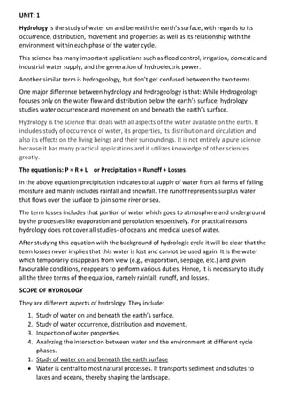
  • 1. UNIT: 1 Hydrology is the study of water on and beneath the earth’s surface, with regards to its occurrence, distribution, movement and properties as well as its relationship with the environment within each phase of the water cycle. This science has many important applications such as flood control, irrigation, domestic and industrial water supply, and the generation of hydroelectric power. Another similar term is hydrogeology, but don’t get confused between the two terms. One major difference between hydrology and hydrogeology is that: While Hydrogeology focuses only on the water flow and distribution below the earth’s surface, hydrology studies water occurrence and movement on and beneath the earth’s surface. Hydrology is the science that deals with all aspects of the water available on the earth. It includes study of occurrence of water, its properties, its distribution and circulation and also its effects on the living beings and their surroundings. It is not entirely a pure science because it has many practical applications and it utilizes knowledge of other sciences greatly. The equation is: P = R + L or Precipitation = Runoff + Losses In the above equation precipitation indicates total supply of water from all forms of falling moisture and mainly includes rainfall and snowfall. The runoff represents surplus water that flows over the surface to join some river or sea. The term losses includes that portion of water which goes to atmosphere and underground by the processes like evaporation and percolation respectively. For practical reasons hydrology does not cover all studies- of oceans and medical uses of water. After studying this equation with the background of hydrologic cycle it will be clear that the term losses never implies that this water is lost and cannot be used again. It is the water which temporarily disappears from view (e.g., evaporation, seepage, etc.) and given favourable conditions, reappears to perform various duties. Hence, it is necessary to study all the three terms of the equation, namely rainfall, runoff, and losses. SCOPE OF HYDROLOGY They are different aspects of hydrology. They include: 1. Study of water on and beneath the earth’s surface. 2. Study of water occurrence, distribution and movement. 3. Inspection of water properties. 4. Analyzing the interaction between water and the environment at different cycle phases. 1. Study of water on and beneath the earth surface • Water is central to most natural processes. It transports sediment and solutes to lakes and oceans, thereby shaping the landscape.
  • 2. • Hydrologic science has an important place in the field of water resources, especially freshwater resources, which are the subject of intense concern and study. • Water exists on the earth’s surface as surface water. • This includes both the saltwater in the ocean and the freshwater in rivers, streams, and lakes. • Surface water is an important source of drinking water and is used for the irrigation of farmland. • Water exists below the earth’s surface as groundwater. • Groundwater is the water present beneath Earth’s surface in soil pore spaces, underground bedrocks and in the fractures of rock formations. • Groundwater moves slowly through underground rock layers called aquifers and accounts for approximately 30% of fresh water on earth. • Surface water and groundwater are reservoirs that can feed into each other. • Surface water can seep underground to become groundwater, groundwater can also resurface on land to replenish surface water. 2. Study of water occurrence, distribution and movement • Water circulates throughout the Earth through different pathways and at different rates. • Hydrology is concerned with the continuous circulation of water in the air- atmosphere system, the hydrologic cycle. • The hydrologic cycle describes how water evaporates from the surface of the earth, rises to the atmosphere, cools and condenses into rain or snow in clouds, and falls again to the surface as precipitation. • Water takes on various forms in the environment in response to changes in temperature and other influences. • It also exists in various quantities and quality as it moves through the cycle. • Water content trapped by trees and plants also returns back to the atmosphere through transpiration or in a more general phase called evapotranspiration. • Parts of hydrology involves developing methods for directly measuring these flows or amounts of water available as well as modelling these processes either for scientific knowledge or for making a prediction in practical applications. 3. Inspection of water properties • Hydrology also deals with the physical and chemical properties of water in all its phases. • Different phase exhibits different water properties and this affects water usage. • As a result of thermal content, the kinetic energy of water varies in different states resulting in varying water properties. • The temperature, turbidity, pH levels, taste, and many more properties are key factors of a hydrologic datasheet.
  • 3. 4. Analyzing the interaction between water and the environment at different cycle phases • Apart from studying the natural distribution and movement of water, hydrology is also concerned with the impact of human activities on water quality as well as water management problems. • A change in water quality or quantity can affect the local environment positively or otherwise. • These changes can be: man-made (e.g. a dam release); weather-related (flooding), or a combination of both factors (i.e. rainfall-runoff caused by poor agricultural practices). • Regardless of the cause, hydrologic data assists in explaining water quality and environmental changes. Importance of water Water is one of the most important resources on the planet. Without water, life cannot exist. But what makes water so important? Water has several unique characteristics that make it an extremely valuable resource. Some such properties of water are listed below. Water is a very good solvent – it has the ability to dissolve many substances. The boiling point and freezing point of water make it easily available in all three states (solid, liquid, and gaseous). The specific heat of water is quite high. This enables water to absorb and release heat slowly, thereby regulating the temperature of its environment. Owing to its transparency, water can allow light to reach the life forms that are submerged in it. This is crucial for the survival of plant life in the oceans, lakes, and rivers. Water is neither acidic nor basic in nature. It has a pH of 7, making it a neutral substance. These unique qualities of water, along with its abundance on the planet (approximately 71% of the Earth’s surface is made up of water), make it a crucial resource for plants, animals, and human beings. Importance of Water in Living Organisms • Water is the medium through which all essential vitamins and minerals are transported in the bodies of living organisms (owing to its ability to dissolve a wide range of substances). • Water also plays a vital role in facilitating the work of enzymes in living organisms. For example, the sodium bicarbonate secreted by the pancreas is broken down into ions by water, making the medium sufficiently alkaline for the enzymes to work. • Water helps maintain body temperatures in plants and animals. In order to decrease the temperature in their bodies, animals lose water via perspiration (sweating) and plants lose water via transpiration.
  • 4. • Since water can rise in capillary tubes without any external help, it can be transported from the roots of trees to every other part of the tree. • Water is an integral part of photosynthesis. Without it, autotrophic plants would not be able to produce their own food. • Water serves as a habitat for more than 50% of all life on Earth. Importance of Water in Human Beings • Insufficient water content in the human body results in severe dehydration, which is often accompanied by kidney failure, seizures, and swelling in the brain. • Water helps improve the circulation of oxygen throughout the body. • It also plays a crucial role in the digestion of food. • Water is a very important component of saliva, which helps break down food. • The excretion of waste in the human body requires water. Insufficient water levels in the body may increase the strain on the kidneys, resulting in the formation of kidney stones. Other Important Uses of Water • If not for the high specific heat of water, the temperature of the Earth’s surface would be much lower. This would make it difficult for life to survive. • The water in the Earth’s oceans absorb heat from the sun during the day and help maintain the temperature during the night. • Water is necessary for the irrigation of crops and is, therefore, an integral part of agriculture. • It is widely used in cooking activities since it boils at a temperature of 100o • Humans make use of water for a wide range of domestic activities such as washing and cleaning. • Water also serves as a medium for the transportation of cargo. Many goods are transported between the Earth’s continents via ships. Industrial Uses of Water • Many industries require large quantities of water for processing, cooling, and diluting products. Examples of industries that consume large quantities of water include the paper industry, the food industry, and the chemical industry. • Water is also used as an industrial solvent for the production of several commercially important products. Almost all power plants that generate electricity employ water to spin turbines.
  • 5. • Heavy water, an important form of water, is widely used in nuclear reactors as a neutron moderator. Hydrological Cycle: • Hydrological cycle is also known as “water cycle” and there is a continuous exchange of water between the atmosphere, the oceans and the continents through the processes of evaporation, transpiration, condensation and precipitation. As the moisture which is present in the atmosphere is taken from water bodies through a process called evaporation and from plants through a process called transpiration (evapotranspiration). Further this evaporation undergoes condensation for the formation of clouds and once after the formation of clouds they fall down in the form of raindrops through precipitation process. • As the total amount of water vapour present in the atmosphere is constant, to maintain this there should be a proper balance between evapotranspiration and precipitation. And the cycle which maintains this stability is the Hydrological cycle. • This cycle does not have any starting and ending point, as it leads to continuous circulation of water present on the Earth which causes evolution of the Earth. The factor that assists hydrological cycle or water cycle is the sun, air currents to name a few. Process of the Water Cycle Water cycle is completed in various stages or process they are: 1. Stage I: Evaporation and Transpiration: • In this process energy from the sun heats up the lakes, rivers, oceans, swamps and other water bodies which subsequently increase the temperature of the water present in them. This leads to evaporation of some water into air and the rising air current takes the vapour up in the sky. • Along with this process at the same time plants and trees also lose water to the atmosphere in the form of vapour which rises up in the sky. 2. Stage II: Condensation • In this process the vapour which rises up gets cooled because of cooler temperature in the surrounding. Because of this water vapour turns back into liquid through the condensation process. 3. Stage III: Precipitation • In this process there occurs collisions in the cloud particles because of wind movements. Because of this clouds become water laden and they develop into rain bearing clouds and fall back onto the earth’s surface by the process known as precipitation. • They may fall on the Earth in the form of rain, hail, snow or sleet depending upon the temperature conditions.
  • 6. 4. Stage IV: Runoff and Infiltration • After the precipitation process, precipitated water runs off into oceans, rivers and ground surface or is absorbed into the soil (infiltration). • After going through all these steps water is again ready to go through evaporation and resume earlier stages. • By going through all these processes of hydrological cycle or water cycle water is bringed back to people in the form of fresh water. Water Storage Water storage is a broad term referring to storage of both potable water for consumption, and non potable water for use in agriculture. In both developing countries and some developed countries found in tropical climates, there is a need to store potable drinking water during the dry season. In agriculture water storage, water is stored for later use in natural water sources, such as groundwater aquifers, soil water, natural wetlands, and small artificial ponds, tanks and reservoirs behind major dams. Storing water invites a host of potential issues regardless of that waters intended purpose, including contamination through organic and inorganic means. Types 1. Groundwater • Groundwater is located beneath the ground surface in soil pore spaces and in the fractures of rock formations. A unit of rock or an unconsolidated deposit is called an aquifer when it can yield a usable quantity of water. The depth at which soil pore spaces or fractures and voids in rock become completely saturated with water is called the water table. There are two broad types of aquifers: An unconfined aquifer is where the surface is not restricted by impervious rocks, so the water table is at atmospheric pressure. In a confined aquifer, the upper surface of water is overlain by a layer of impervious rock, so the groundwater is stored under pressure. • Aquifers receive water through two ways, one from precipitation that that flows through the unsaturated zone of the soil profile, and two from lakes and rivers. When a water table reaches capacity, or all soil is completely saturated, the water table meets the surface of the ground where water discharge in the forms of springs or seeps. • It is also possible to artificially recharge aquifers (using wells), for example through the use of Aquifer storage and recovery (ASR). 2. Soil moisture • Groundwater is stored in two zones, one being the saturated zone, or Aquifer, the other is the pore space of unsaturated soil immediately below the ground surface. Soil moisture is the water held between soil particles in the root zone (rhizosphere) of plants, generally in the top 200 cm of soil. Water storage in the soil profile is extremely important for agriculture, especially in locations that rely on rainfall for
  • 7. cultivating plants. For example, in Africa rain-fed agriculture accounts for 95% of farmed land. 3. Wetlands • Wetlands span the surface/sub-surface interface, storing water at various times as groundwater, soil moisture and surface water. They are vital ecosystems that support wildlife and perform valuable ecosystem services, such as flood protection and water cleansing. They also provide livelihoods for millions of people who live within and around them. For example, the Inner Niger River Delta in the Western Sahel zone supports more than a million people who make their living as fishermen, cattle breeders or farmers, using the annual rise and fall of the river waters and its floodplains. • Wetlands are basically sponges that capture and slowly release large amounts of rain, snowmelt, groundwater and floodwater. Trees and other wetlands vegetation slow the speed of flood water and more evenly distribute it across the wetland. The combination of increased water storage and flood water hindrances lower flood heights and reduce erosion. 4. Ponds and tanks • Detention basins and water tanks can be defined as community-built and household water stores, filled by rainwater, groundwater infiltration or surface runoff. They are usually open, and therefore exposed to high levels of evaporation. They can be a great help to farmers in helping them overcome dry spells. However, they can promote vector-borne diseases such as malaria or schistosomiasis. • Detention basins are designed for temporary capture of flood waters and do not allow for permanent pooling of water and therefore do not make viable or reliable sources of water storage. Retention basins are similar to detention basins for flood control management, but are built for permanent pooling to control sediment and pollutants in the flood water. 5. Dams and reservoirs • In the past, large dams have often been the focus of water storage efforts. Many large dams and their reservoirs have brought significant social and economic benefits. For example, Egypt's Aswan High Dam, built in the 1960s, has protected the nation from drought and floods and supplies water used to irrigate some 15 million hectares. However, dams can also have great negative impacts. Because sediment is trapped by the Aswan High Dam, the Nile no longer delivers nutrients in large quantities to the floodplain. This has reduced soil fertility and increased the need for fertilizer.[9] Water stored in dams and reservoirs can be treated for drinking water, but in the past due to poor taxing and high water prices in the US, water supply dams are unable to reach their intended levels of operation.[10] Due to the increased surface area of water that dams create, huge amounts of water is lost to evaporation, much more so than what would have been lost from the river that flowed in its place.
  • 8. UNIT: 2 Surface water is water located on top of the Earth's surface, and may also be referred to as blue water. In common usage, it is usually used specifically for terrestrial (inland) waterbodies, the vast majority of which is produced by precipitation and runoff from nearby higher areas. • As the climate warms in the spring, snowmelt runs off towards nearby streams and rivers contributing towards a large portion of human drinking water. Levels of surface water lessen as a result of evaporation as well as water moving into the ground becoming ground-water. • Alongside being used for drinking water, surface water is also used for irrigation, wastewater treatment, livestock, industrial uses, hydropower, and recreation. For USGS water-use reports, surface water is considered freshwater when it contains less than 1,000 milligrams per liter (mg/L) of dissolved solids. • There are three major types of surface water. Permanent (perennial) surface waters are present year round, and includes lakes, rivers and wetlands (marshes and swamps). Semi-permanent (ephemeral) surface water refers to bodies of water that are only present at certain times of the year including seasonally dry channels such as creeks, lagoons and waterholes. Man-made surface water is water that can be continued by infrastructures that humans have assembled. This would be dammed artificial lakes, canals and artificial ponds (e.g. garden ponds) or swamps. The surface water held by dams can be used for renewable energy in the form of hydropower. Hydropower is the forcing of surface water sourced from rivers and streams to produce energy. FACTOR AFFECTING QUANTITY • Land use • Soil type • Geology • Vegetation • Slope • Climate FACTOR AFFECTING QUALITY • Sedimentation • Runoff • Erosion • Dissolved oxygen • pH • Temperature • Decayed organic materials • Pesticides
  • 9. • Toxic and hazardous substances • Oils, grease, and other chemicals • Detergents • Litter and rubbish Precipitation is any form of moisture which falls to the earth. This includes rain, snow, hail and sleet. • Precipitation occurs when water vapour cools. When the air reaches saturation point (also known as condensation point and dew point) the water vapour condenses and forms tiny droplets of water. These tiny droplets of water from clouds. • Complex forces cause the water droplets to fall as rainfall. • All rain is the same. It happens as the result of warm, moist air being cooled, leading to condensation and in turn rain. The following examples show three different ways air is cooled causing rainfall. Forms of precipitation 1. Rain: • Rain in the form of precipitation occurs in the form of water drops. • These water drops are of a size larger than 0.5mm. The maximum size of the raindrop is approximately 6mm. • In case, the droplets are larger than 6mm, they break down into smaller droplets and fall on the earth. • Rainfall is an essential form of precipitation that contributes significantly to the water resources of the earth as well as an important constituent of the ecological cycle. • The magnitude of rainfall even indicates the high temporal and spatial variation. Such variations are responsible for the occurrence of various extreme hydrological conditions such as floods, famines and droughts. 2. Snow: • Snow is the form of precipitation that consists of crystals of ice in a flaky form. • It usually has an average density of 0.1gm/cc. • Snow is also a chief contributor to the water resources of the earth. 3. Drizzle: • It is the form of precipitation that is similar to rain. • However, the drizzle consists of water droplets with a size of less than 0.5mm.
  • 10. 4. Sleet: • Sleet is the form of precipitation that exists in the form of frozen droplets of rain. • The freezing of the droplets mostly occurs when the droplets pass through the air at freezing temperatures. 5. Glaze: • The glaze is also commonly referred to as freezing rain. • It is the form of precipitation that is formed when the rain or drizzle comes in contact with the cold ground usually at 0 degrees Celsius. 6. Hail: • Hail is the form of precipitation that exists in the form of lumps or pellets with a size greater than 8mm. Types of Precipitation 1. Cyclonic Precipitation • Cyclonic precipitation generally refers to the precipitation that occurs by the cyclonic movement or action of the moist mass of air. • A cyclone is a phenomenon that occurs in the atmosphere consisting of low pressure and circular wind motion. Thus, cyclonic precipitation is the type of precipitation that occurs due to such cyclonic action with the aid of the pressure difference. The cyclonic precipitation can be classified into the following: • Frontal It is the hot moist air mass boundary that occurs due to the expansion of air near the frontal surface. • Non-Frontal It is a cold air mass boundary that occurs due to the movement of the cold mass of moist air that results in precipitation. 2. Convective Precipitation
  • 11. • Convective precipitation is the type of precipitation that results from the convective movement of the air. • In actuality, the air present above the surface of land gets heated and this warmer air being lighter moves up, cools down and thus precipitates. • The convective precipitation mostly occurs in varying intensities and in the form of showers. • The areal extent of such precipitation is relatively smaller and usually is in the range of less than 10km in diameter. 3. Orographic Precipitation • Orographic precipitation is the type of precipitation that occurs by the orographic action i.e. the movement of the moist mass of air in the windward side of the mountain. • In other words, moving air masses have chances to strike barriers like mountains. Once they strike, they rise which causes condensation and precipitation. • The precipitation is greater on the windward side of the barrier compared to the leeward side of the barrier. Causes of Precipitation
  • 12. 1. Frontal Activity • Frontal precipitation occurs as a consequence of slow ascent of air in synoptic systems (on the order of cm/s), such as over surface cold fronts, and over and ahead of warm fronts. • A similar ascent is seen around tropical cyclones outside of the eyewall and in comma-head precipitation patterns around mid-latitude cyclones. • It is also called stratiform or dynamic precipitation. 2. Convection • It is the most common cause of precipitation in tropical areas. • Convectional clouds fall as showers with rapidly changing intensity. • Convective precipitation falls over a certain area for a relatively short time, as convective clouds have a limited horizontal extent. • It is also called showery precipitation 3. Orographic Action • Orographic precipitation occurs on the windward (upwind) side of mountains and is caused by the rising air motion of a large-scale flow of moist air across the mountain ridge, resulting in adiabatic cooling and condensation. Factors of precipitation 1. Moisture supply: A rule of thumb is that when the relative humidity reaches or exceeds 70% at 850 mb (around 1,500 meters or 5,000 ft. above sea level), overcast conditions are usually observed, and when relative humidity reaches 90% or more, then precipitation often occurs. We will define an intermediate value of relative humidity, 80%, to be "favorable" for precipitation. 2. Frontal Position: To decide whether or not a front is close enough to be "favorable" for precipitation at our forecast location, we define a circular region centered on our forecast location with a radius of 140 miles (about 2° of latitude). (See a map showing this frontal influence region used for scoring purposes.) If a front of any type is reported within this area during the 24 hour period between 12Z and 12Z, we define it to be a factor favoring precipitation. You can use the NWS forecast frontal positions to help you with this. 3. Unstable Atmosphere: An unstable atmosphere is one that favors unassisted or unforced, buoyant, upward air motion, which can lead to cumulonimbus clouds. Interception refers to precipitation that does not reach the soil, but is instead intercepted by the leaves, branches of plants and the forest floor. It occurs in the canopy (i.e. canopy interception), and in the forest floor or litter layer (i.e. forest floor interception). Because of evaporation, interception of liquid water generally leads to loss of that precipitation for the drainage basin, except for cases such as fog interception, but increase flood protection dramatically, Alila et al., (2009).
  • 13. • Interception deals with the amount of water that is caught and stored on the leaves and stems of vegetation. The term vegetation includes forest tree cover, crops and low level vegetation like under-bush, grass etc. Part of the precipitation which falls either as rainfall or snowfall is caught by vegetative cover before it reaches ground. • This is a matter of common experience when the people take shelter below a tree during rainfall. The rain drops or snowflakes are retained by the leaves as droplets or thin layers on their surface or in the depression of the leaves.Factors Factors affecting interception (i) Type of Vegetation: • Interception varies with the species, its age and density of stands. About 10 to 20% of precipitation occurring in the growing season is intercepted. It is lost substantially by way of evaporation from leaves. In dense tall vegetation interception is quite substantial. • So interception by low-lying vegetation is usually negligible for hydrologic studies. But if such vegetation cover exists below the forest canopy it affects runoff substantially. Dense grasses and herbs approaching full growth intercept as much precipitation as forest cover. However, since their season is short total amount intercepted is considerably less than the forest cover. (ii) Wind Velocity: • If the wind accompanies the precipitation the leaves become incapable of holding much water as compared with the still air condition. On the other hand due to blowing of wind the evaporation rate also increases. It is thus seen that during short storm interception decreases but during long storm interception is augmented due to increased evaporation. (iii) Duration of Storm: • Interception storage is filled up in the first part of a rain storm. Therefore, if yearly precipitation is made up of several small duration storms separated by dry spells evaporation will be high and interception will be consequently more. However, if storms of long duration occur and if weather remains cloudy, relatively interception loss will be less. (iv) Intensity of Storm: • When precipitation occurs in still air conditions with low intensity interception will be more. On the contrary if rain drops come with great speed their impact dislodges intercepted drops and leaves cannot hold much water. (v) Season of the Year:
  • 14. • During summer or dry season the interception rate is quite high because of high evaporation. Summer interception is 2 to 3 times more than the winter season interception. (vi) Climate of the Area: • In arid and semiarid regions due to prevailing dry conditions the interception loss is more than that occurring in humid regions. Surface run-off • Runoff, in hydrology, quantity of water discharged in surface streams. Runoff includes not only the waters that travel over the land surface and through channels to reach a stream but also interflow, the water that infiltrates the soil surface and travels by means of gravity toward a stream channel (always above the main groundwater level) and eventually empties into the channel. • Runoff also includes groundwater that is discharged into a stream; streamflow that is composed entirely of groundwater is termed base flow, or fair-weather runoff, and it occurs where a stream channel intersects the water table. • The total runoff is equal to the total precipitation less the losses caused by evapotranspiration (loss to the atmosphere from soil surfaces and plant leaves), storage (as in temporary ponds), and other such abstractions. Sources of Surface run-off • Excess rainwater • Stormwater • Meltwater Factors affecting runoff Meteorological factors affecting runoff: • Type of precipitation (rain, snow, sleet, etc.) • Rainfall intensity • Rainfall amount • Rainfall duration • Distribution of rainfall over the drainage basin • Direction of storm movement • Precipitation that occurred earlier and resulting soil moisture • Other meteorological and climatic conditions that affect evapotranspiration, such as temperature, wind, relative humidity, and season Physical characteristics affecting runoff: • Land use • Vegetation • Soil type
  • 15. • Drainage area • Basin shape • Elevation • Topography, especially the slope of the land • Drainage network patterns • Ponds, lakes, reservoirs, sinks, etc. in the basin, which prevent or delay runoff from continuing downstream Evaporation is a process by which water is transformed from liquid to a gaseous state. Heat is the main cause of evaporation. The temperature at which the water starts evaporating is referred to as the latent heat of vapourisation. An increase in temperature increases the water absorption and retention capacity of the given parcel of air. Similarly, if the moisture content is low, the air has the potentiality of absorbing and retain moisture. The movement of air replaces the saturated layer with the unsaturated layer. Hence, the greater the movement of air, the greater is the evaporation. Measurement of evaporation • Theoretically speaking, evaporation can be measured on the basis of rate of vaporization over any water level. This is possible only in laboratories. This function is very difficult in open water area because nature cannot be controlled so minutely. John Dalton discovered the ‘Rule of Partial Pressure’ in 1801. He tried to measure evaporation indirectly by measuring air on water level and pressure of vapour by using an equation which was later on revised by many researchers. His method is called ‘Mass Transfer Method’ of measuring evapo­ration. • As per one estimate, 4, 55,000 cubic kms water from the sea reach’s in the atmosphere every year through evaporation. Similarly, 62,000 cubic kms reaches the atmosphere through evaporation from water sources situated on the earth. As against it, when 98,000 cubic kms water through evaporation enters into the atmosphere, it is absorbed in it. • Water vapour can be absorbed in atmosphere in a definite quantity. As soon as the relative humidity becomes 100 per cent, air is called saturated. It has been seen that hardly one per cent of the total water available on earth is used by the hydrological cycle. It normally believed that nowhere is there equality between evaporation and precipitation.
  • 16. • As estimated by M. I. Budyoko (1971), evaporation from oceans is more than rain. According to him, loss of 46,000 cubic kms water takes place from oceans every year. On the other side, 62,000 cubic kms water evaporates every year from the land, but It receives 1, 08,000 cubic kms water through rain. Hence, the land receives 46,000 cubic kms additional water every year. Such additional water again reaches oceans through surface flow. Thus, more rain is received by continents as compared to evaporation. Evapotranspiration (or "ET") is the water lost through plant transpiration and soil and plant evaporation. The images below help explain what ET is and how it occurs. •
  • 17. • Evapotranspiration (ET) is the combination of evaporation and transpiration. Evaporation is water movement from wet soil and leaf surfaces. Transpiration is water movement through the plant. This water movement helps move vital nutrients through the plant. • Evapotranspiration (ET) is an energy-driven process. ET increases with temperature, solar radiation, and wind. ET decreases with increasing humidity. Atmospheric factors affecting transpiration The amount of water that plants transpire varies greatly geographically and over time. There are a number of factors that determine transpiration rates: • Temperature: Transpiration rates go up as the temperature goes up, especially during the growing season, when the air is warmer due to stronger sunlight and warmer air masses. Higher temperatures cause the plant cells which control the openings (stoma) where water is released to the atmosphere to open, whereas colder temperatures cause the openings to close. • Relative humidity: As the relative humidity of the air surrounding the plant rises the transpiration rate falls. It is easier for water to evaporate into dryer air than into more saturated air. • Wind and air movement: Increased movement of the air around a plant will result in a higher transpiration rate. Wind will move the air around, with the result that the more saturated air close to the leaf is replaced by drier air. • Soil-moisture availability: When moisture is lacking, plants can begin to senesce (premature aging, which can result in leaf loss) and transpire less water. • Type of plant: Plants transpire water at different rates. Some plants which grow in arid regions, such as cacti and succulents, conserve precious water by transpiring less water than other plants. Controlling factors
  • 18. • Energy availability. The more energy available, the greater the rate of evapotranspiration. It takes about 600 calories of heat energy to change 1 gram of liquid water into a gas. • The humidity gradient away from the surface. The rate and quantity of water vapor entering into the atmosphere both become higher in drier air. • The wind speed immediately above the surface. The process of evapotranspiration moves water vapor from ground or water surfaces to an adjacent shallow layer that is only a few centimeters thick. When this layer becomes saturated evapotranspiration stops. However, wind can remove this layer replacing it with drier air which increases the potential for evapotranspiration. Winds also affect evapotranspiration by bringing heat energy into an area. A 5-mile-per-hour wind will increase still-air evapotranspiration by 20 percent; a 15-mile-per-hour wind will increase still-air evapotranspiration by 50 percent. • Water availability. Evapotranspiration cannot occur if water is not available. • Physical attributes of the vegetation. Such factors as vegetative cover,plant height, leaf area index and leaf shape and the reflectivity of plant surfaces can affect rates of evapotranspiration. For example coniferous forests and alfalfa fields reflect only about 25 percent of solar energy, thus retaining substantial thermal energy to promote transpiration; in contrast, deserts reflect as much as 50 percent of the solar energy, depending on the density of vegetation. • [Stomatal resistance]. Plants regulate transpiration through adjustment of small openings in the leaves called stomata. As stomata close, the resistance of the leaf to loss of water vapor increases, decreasing to the diffusion of water vapor from plant to the atmosphere. • Soil characteristics. Soil characteristics that can affect evapotranspiration include its heat capacity, and soil chemistry and albedo.
  • 19. Unit 3: Groundwater • Groundwater is used for drinking water by more than 50 percent of the people in the United States, including almost everyone who lives in rural areas. The largest use for groundwater is to irrigate crops. • Aquifers are typically made up of gravel, sand, sandstone, or fractured rock, like limestone. Water can move through these materials because they have large connected spaces that make them permeable. The speed at which groundwater flows depends on the size of the spaces in the soil or rock and how well the spaces are connected. • Groundwater can be found almost everywhere. The water table may be deep or shallow; and may rise or fall depending on many factors. Heavy rains or melting snow may cause the water table to rise, or heavy pumping of groundwater supplies may cause the water table to fall. • Groundwater supplies are replenished, or recharged, by rain and snow melt that seeps down into the cracks and crevices beneath the land's surface. In some areas of the world, people face serious water shortages because groundwater is used faster than it is naturally replenished. In other areas groundwater is polluted by human activities. • Water in aquifers is brought to the surface naturally through a spring or can be discharged into lakes and streams. Groundwater can also be extracted through a well drilled into the aquifer. A well is a pipe in the ground that fills with groundwater. This water can be brought to the surface by a pump. Shallow wells may go dry if the water table falls below the bottom of the well. Some wells, called artesian wells, do not need a pump because of natural pressures that force the water up and out of the well. • In areas where material above the aquifer is permeable, pollutants can readily sink into groundwater supplies. Groundwater can be polluted by landfills, septic tanks, leaky underground gas tanks, and from overuse of fertilizers and pesticides. If groundwater becomes polluted, it will no longer be safe to drink. Stream flow Streamflow, or channel runoff, is the flow of water in streams, rivers, and other channels, and is a major element of the water cycle. It is one component of the runoff of water from the land to waterbodies, the other component being surface runoff. Water flowing in channels comes from surface runoff from adjacent hillslopes, from groundwater flow out of the ground, and from water discharged from pipes. The discharge of water flowing in a channel is measured using stream gauges or can be estimated by the Manning equation.
  • 20. The record of flow over time is called a hydrograph. Flooding occurs when the volume of water exceeds the capacity of the channel. Streamflow characteristics offer some of the most appropriate and useful indicators for assessing watershed health. They are extremely sensitive to human activities and reflect weather and climate conditions, vegetation and soil type, land characteristics, and human use. Common human activities, such as increasing the number of roads and parking lots, change the timing and strength of runoff events resulting in "flashy" systems. Such hydrologic variation shapes the biotic diversity within stream ecosystems by controlling critical habitat conditions. Characteristic of stream flow 1. Rainfall characteristics • Magnitude intensity • Distribution according to time and's pace. • Variability. 2. Catchment characteristics • Soil • Vegetation • Slope, geology, shape • Drainage basin 3. Climatic factor Type of stream • Perennial o Always carry some flow (all over year) o Groundwater flow throughout the year o Flow above bed of stream (dry season) • Intermittent o Groundwater (limited contribution) o No groundwater during dry season. o Dependable flow 0 • Ephemeral o No base flow contribution. o Water available during rainy seasons. o Dry in dry season
  • 21. Darcy law’s • In 1856, french hydraulic engineer Henry Darcy published a report on the water supply of the city of Dijon in France. In that report, Darcy described the result of an experiment designed to study the flow of water through a porous medium. • Darcy’s experiment resulted in the formulation of mathematical law that describes fluid motion in porous media. • Darcy’s law states that the rate of fluid flow through porous medium is proportional to the potential energy gradient within that fluid. The constant of proportionality is the Darcy’s permeability of soil. • Darcy’s permeability is a property of both porous medium and the fluid moving through the porous medium. In fact, Darcy’s law is the empirical equivalent of the Navier-Strokes equation. • Darcy’s flow velocity for laminar flow is defined as the quantity of fluid flow along the hydraulic gradient per unit cross sectional area. Velocity of flow through a porous media is directly proportional to the hydraulic gradient responsible for flow. Here, • V = discharge velocity or superficial velocity • k = coefficient of permeability or hydraulic conductivity • i = hydraulic gradient • = fall in total head • L = length of soil specimen Assumptions of Darcy’s Law • Soil is fully saturated. • Temperature during testing is 27°C. • Flow through soil is laminar • Entire cross-sectional area is available for flow
  • 22. • Flow is continuous and steady. Validity of Darcy’s Law Darcy’s law is valid only for slow and viscous flow, fortunately most groundwater flow cases fall in this category. Typically, any flow with a Reynolds number less than 1 is clearly laminar and it would be valid to apply Darcy’s law. Experimental tests have shown that flow regimes with values of Reynolds number upto 10 may still be Darcine. Permeability • The ability of soil to allow flow of water through it is called as permeability of soil. It is very important factor for the structures which are in contact with water. • Flow of water in soil takes place through void spaces, which are interconnected. Water does not flow in a straight line, but in a winding path. However in soil mechanics flow is considered to be in a straight line at an effective velocity. • The velocity of flow depends on size of pores. Importance of Permeability of Soil • Permeability influences the rate of settlement of a saturated soil under load. • The stability of slopes and retaining structures can be greatly affected by the permeability involved. • The design of earth dams is very much based upon the permeability of soil used. • Filters made of soils are designed based upon their permeability. Properties of Permeability of Soil • Solving problems involving pumping seepage water from construction excavation. • Estimating the quantity of underground seepage. • Stability analysis of earth structures and earth retaining walls subjected to seepage forces. Factors Affecting Permeability of Soil • Grain size or Particle size The above equation is given by Alan Hazen. Permeability depends on shape and soil of soil particles.Permeability varies with square of particle size diameter. • Void Ratio If the presence of voids is more then the permeability is also more.
  • 23. • Composition For gravels, sand and silts presence of mica can decrease the permeability of soil. For clay, water attracted between clay particles reduces the permeability. • Structural Arrangement Remolding of natural soil reduces permeability. If soil contains more rounded particles, the permeability is more. • Stratification When flow of water is parallel to strata, permeability will be more when compared with flow perpendicular to strata. • Presence of foreign particles and entrapped air This affects the permeability as it reduces void space and it blocks the inter-connectivity between the pores. • Degree of saturation If the soil is dry or partly saturated the permeability of soil is always less. Permeability Range of Different Soil Mass • Gravel – cm/s • Sand – – cm/s • Silt – – cm/s • Clay – – cm/s Infiltration • Infiltration is the process by which water on the ground surface enters the soil. It is commonly used in both hydrology and soil sciences. The infiltration capacity is defined as the maximum rate of infiltration. It is most often measured in meters per day but can also be measured in other units of distance over time if necessary. • The infiltration capacity decreases as the soil moisture content of soils surface layers increases. If the precipitation rate exceeds the infiltration rate, runoff will usually occur unless there is some physical barrier. • Infiltrometers, permeameters and rainfall simulators are all devices that can be used to measure infiltration rates. • Infiltration is caused by multiple factors including; gravity, capillary forces, adsorption and osmosis. Many soil characteristics can also play a role in determining the rate at which infiltration occurs. Factors that affect infiltration
  • 24. 1. Precipitation • Precipitation can impact infiltration in many ways. The amount, type and duration of precipitation all have an impact. Rainfall leads to faster infiltration rates than any other precipitation events, such as snow or sleet. • In terms of amount, the more precipitation that occurs, the more infiltration will occur until the ground reaches saturation, at which point the infiltration capacity is reached. Duration of rainfall impacts the infiltration capacity as well. • Initially when the precipitation event first starts the infiltration is occurring rapidly as the soil is unsaturated, but as time continues the infiltration rate slows as the soil becomes more saturated. This relationship between rainfall and infiltration capacity also determines how much runoff will occur. If rainfall occurs at a rate faster than the infiltration capacity runoff will occur. 2. Soil characteristics • The porosity of soils is critical in determining the infiltration capacity. Soils that have smaller pore sizes, such as clay, have lower infiltration capacity and slower infiltration rates than soils that have large pore size, such as sands. One exception to this rule is when clay is present in dry conditions. In this case, the soil can develop large cracks which leads to higher infiltration capacity. • Soil compaction also impacts infiltration capacity. Compaction of soils results in decreased porosity within the soils, which decreases infiltration capacity. • Hydrophobic soils can develop after wildfires have happened, which can greatly diminish or completely prevent infiltration from occurring. 3. Soil moisture content • Soil that is already saturated has no more capacity to hold more water, therefore infiltration capacity has been reached and the rate cannot increase past this point. This leads to much more surface runoff. When soil is partially saturated then infiltration can occur at a moderate rate and fully unsaturated soils have the highest infiltration capacity. 4. Organic materials in soils • Organic materials in the soil (including plants and animals) all increase the infiltration capacity. Vegetation contains roots that extend into the soil which create cracks and fissures in the soil, allowing for more rapid infiltration and increased capacity. • Vegetation can also reduce surface compaction of the soil which again allows for increased infiltration. When no vegetation is present infiltration rates can be very low, which can lead to excessive runoff and increased erosion levels.[3] Similarly to vegetation, animals that burrow in the soil also create cracks in the soil structure. 5. Land cover
  • 25. • If land is covered by impermeable surfaces, such as pavement, infiltration cannot occur as the water cannot infiltrate through an impermeable surface This relationship also leads to increased runoff. Areas that are impermeable often have storm drains which drain directly into water bodies, which means no infiltration occurs. • Vegetative cover of the land also impacts the infiltration capacity. Vegetative cover can lead to more interception of precipitation, which can decrease intensity leading to less runoff, and more interception. Increased abundance of vegetation also leads to higher levels of evapotranspiration which can decrease the amount of infiltration rate. Debris from vegetation such as leaf cover can also increase infiltration rate by protecting the soils from intense precipitation events. • In semi-arid savannas and grasslands, the infiltration rate of a particular soil depends on the percentage of the ground covered by litter, and the basal cover of perennial grass tufts. On sandy loam soils the infiltration rate under a litter cover can be nine times higher than on bare surfaces. The low rate of infiltration on bare areas is due mostly to the presence of a soil crust or surface seal. Infiltration through the base of a tuft is rapid and the tufts funnel water towards their own roots. 6. Slope • When the slope of land is higher runoff occurs more readily which leads to lower infiltration rates. Groundwater storage • Groundwater is the water that percolates the surface of the earth and passes through the voids of rocks to meet the water table. Groundwater is formed when water percolates the surface of the earth and passes through the voids of rocks to meet the water table. These voids may either be interconnected, permitting the movement of water or be isolated, keeping the water stagnant between the interstices. • It can be said that the presence of the groundwater depends largely on the geology of a specific area and the variable porosity of the upper portion of the earth’s crust. The water below the water table or the groundwater reservoir can be extracted by natural phenomena like springs or artificially by constructing infiltration galleries, wells, springs, etc. This process of exploitation is referred to as ‘drainage of groundwater’. Types of groundwater storage 1. Infiltration Galleries • Infiltration galleries are also known as horizontal wells as they are horizontal or nearly horizontal tunnels that are constructed through the water-bearing strata along the banks of the river. The tunnel is often placed at a shallow depth of 3 to 5 meters.
  • 26. 2. Infiltration Wells • Infiltration wells are a series of shallow wells constructed along the banks of a river. The wells collect the river water that seeps through their bottom. They have open joints and are made up of brick masonry. They are usually covered at the top and manholes are provided for carrying out inspections. 3. Springs • Spring is the natural outflow of groundwater to the surface of the earth, indicating that the water table has outcropped. Generally, when a pervious layer is crammed between two impervious layers, it eventually gives rise to springs. In certain springs, discharge of hot water is seen due to the presence of sulphur. o Gravity Springs • A gravity spring is formed when the groundwater table rises and overflows beside a natural valley or a depression. o Surface Springs • In surface springs, an impervious stratum or obstruction supporting the storage becomes inclined. As the stratum is inclined, the water level rises and the water table is exposed to the ground. o Artesian Springs • When water is flowing through a confined aquifer and the above layer is under pressure, it leads to the formation of an artesian spring. 4. Wells A well is a vertically excavated hole on the surface of the earth that facilitates access to groundwater by bringing it up to the surface. Open wells and tube wells are the two types of wells. o Open Wells • An open well is a masonry well having a large diameter. This type of well is excavated only up to a limited depth and is suitable when the discharge is as low as 18 cubic meters per hour. The water must have a critical velocity in order to be withdrawn as higher velocities may disturb the soil grains and the well lining. • Depending on the type of strata available, open wells can be classified as shallow and deep wells. o Tube Wells • A tube well is a tube or long pipe that is bored or drilled deep into the ground. It intercepts one or more strata bearing water and generally has a small diameter.
  • 27. Ground water aquifer in different rock system • Igneous and metamorphic-rock aquifers can be grouped into two categories: crystalline-rock and volcanic-rock. • Spaces in crystalline rocks are microscopically small, few, and generally unconnected. However, because these aquifers extend over large areas, large volumes of water can be withdrawn. Volcanic-rock aquifers have a wide range of chemical, mineralogic, structural, and hydraulic properties due to variations in rock type, ejection, and deposition. • Volcanic rocks have a wide range of chemical, mineralogic, structural, and hydraulic properties, due mostly to variations in rock type and the way the rock was ejected and deposited. Unaltered pyroclastic rocks, for example, might have porosity and permeability similar to poorly sorted sediments. Hot pyroclastic material, however, might become welded as it settles, and, thus, be almost impermeable. Silicic lavas tend to be extruded as thick, dense flows, and they have low permeability except where they are fractured. Basaltic lavas tend to be fluid, and, they form thin flows that have considerable pore space at the tops and bottoms of the flows. Numerous basalt flows commonly overlap, and the flows are separated by soil zones or alluvial material that form permeable zones. Columnar joints that develop in the central parts of basalt flows create passages that allow water to move vertically through the basalt. Basaltic rocks are the most productive aquifers in volcanic rocks. Second answer • Igneous rocks (i.e. rocks formed from the cooling of magma) are comprised of tightly interlocking crystals - primarily crystals of silicate minerals such as quartz, feldspar and amphibole - which tend to be relatively insoluble. In most cases the spaces between crystals are very small. In intrusive igneous rocks these crystals can be quite large (> 1 mm), whereas in volcanic igneous rocks they tend to be much smaller. Some volcanic rocks have vesicular textures caused by the exsolution of gases. Most intrusive igneous rocks (e.g. granitic rocks) are hard and strong, and are less likely to become fractured than other types of rocks. On the other hand, many volcanic rocks are quite well fractured because of their relatively rapid cooling or violent formation. • Sedimentary rocks are formed close to the surface of the earth at relatively low temperatures and pressures. Clastic sedimentary rocks are comprised of weathered and transported fragments of other rocks and minerals. Depending on the degree of sorting and rounding of those fragments, and the extent to which they are cemented together, clastic sedimentary rocks can be quite porous. Some clastic sedimentary rocks are also relatively soft and weak, and are easily susceptible to fracturing. Most sedimentary rocks also have some bedding features that can enhance porosity. Groundwater movement 1. The water cycle moves water through the environment. As water falls to the ground as rain or snow – it can run off into streams, lakes, rivers or bays. Water will
  • 28. evaporate from surface water. Water that evaporates, can later condense (called condensation), forming clouds that can cause rain or snow. 2. Groundwater and surface water are interconnected. When the water table rises above the ground, the groundwater discharges to the surface and becomes surface water. Also, when the water table drops, surface water can recharge the groundwater. 3. An aquifer is an area of underground soil or rock that is filled with water. An aquifer can supply water to a drinking water well. Throughout New England there are two types of aquifers used to supply drinking water. These two types of aquifers are sand and gravel aquifers and bedrock aquifers. 4. The water table is the top of the groundwater. It is the boundary between the saturated zone below the water table and the unsaturated zone above the water table. The water table rises and falls according to the time of year and how much rain or snow we get. 5. Groundwater is recharged from precipitation – either rain or snow melt -that seeps into the ground. 6. A drinking well is a circular hole that extends into the ground until it reaches the groundwater. Wells pump groundwater into our homes. Three basic well types are common throughout New England: dug, driven and drilled wells. Groundwater discharge • Groundwater discharge is the term used to describe the movement of groundwater from the subsurface to the surface. • There is natural discharge which occurs into lakes, streams and springs as well as human discharge, which is generally referred to as pumping. • The natural discharge is controlled by the topography and geology, with groundwater discharging in topographically low areas (for example, valley floors) containing higher permeability sandstone layers or gravels. • When a sandstone unit of the Paskapoo formation is visible, it is called an outcrop and can be associated with groundwater discharge in the form of springs. Importance of Groundwater discharge The term “baseflow” refers to the flow in streams during dry periods. This groundwater- surface water interaction allows water to flow in the stream during the summer months. Baseflow is critical for maintaining habitat and nutrients to the aquatic ecosystem. In addition, some landowners rely on springs for household and/or agricultural uses. Process of groundwater discharge The groundwater discharges into the stream to provide baseflow during hot summer months. This type of discharge is generally continuous along the length of the channel bed as long as it is at the water table.
  • 29. Groundwater also discharges through springs, whereby groundwater moves laterally through permeable sandstone and emerges at an outcrop Paskapoo sandstone outcrops occur when the overlying material, generally glacial till, has eroded away, exposing the sandstone unit. Generally, springs discharge from the upper sandstone unit of the Paskapoo; however, groundwater within deeper sandstone units may also discharge as a spring. Spring discharge can also occur through the overlying gravels before entering the stream. Water is able to move through the gravels due to their high permeability, allowing water to easily flow through. This discharge would not be visible on the surface, but would still be a point source discharge instead of continuous along the bed of the stream channel. In the City of Calgary, springs can be found discharging into the Bow River. A number of springs in Bowmont Park discharge from gravels and then flow on the surface towards the Bpw River. Therefore, the spring outlet appears more like the one illustrated in Figure 2a, but without a visible sandstone unit.
  • 30. Unit 4: Environmental influence on water resources 1. Main climate change consequences • Increases in temperature • Shifts in precipitation patterns and snow cover • Increase in the frequency of flooding and droughts. 2. Negative environmental impacts of water use • Wildlife death • Migration loss of habitat and species diversity • salination • Soil degradation • groundwater contamination Sectoral demand for water 1. Primary energy production 2. Power generation 3. Industry 4. Municipal 5. Agriculture Urban water supply Urban water supply infrastructure includes • Surface water diversions • Wells • Pumps • Transmission pipes and canals • Treatment and storage facilities • Distribution network elements. Sources • Rivers, • Reservoirs • Seawater • Groundwater. Water Harvesting (save) and Water management (wise utilization) • Water scarcity is being driven by two converging phenomena: growing freshwater use and depletion of usable freshwater resources. Water use has been growing globally at more than twice the rate of population increase in the last century, and an
  • 31. increasing number of regions are reaching the limit at which water services can be sustainably delivered, especially in arid regions. Water scarcity will be exacerbated as rapidly growing urban areas place heavy pressure on neighboring water resources. • At the global level, 31 countries are already short of water and by 2025 there will be 48 countries facing serious water shortages. The UN has estimated that by the year 2050, 4 billion people will be seriously affected by water shortages. This will lead to multiple conflicts between countries over the sharing of water. Around 20 major cities in India face chronic or interrupted water shortages. There are 100 countries that share the waters of 13 large rivers and lakes. International accords that will look at a fair distribution of water in such areas will become critical to world peace. India and Bangladesh already have a negotiated agreement on the water use of the Ganges. • Water management, therefore, is the need of time. It is the management of water resources for the coming generations. It involves the activity of planning, developing, distributing and managing the optimum use of water resources. There are different methods through which water management preservation can be done, some of them are explained below. 1. Rainwater harvesting • Rainwater harvesting (RWH) is the collection and storage of rain, rather than allowing it to run off. Rainwater is collected from a roof-like surface and redirected to a tank, cistern, deep pit (well, shaft, or borehole), aquifer, or a reservoir with percolation. Dew and fog can also be collected with nets or other tools. Rainwater harvesting differs from stormwater harvesting as the runoff is collected from roofs, rather than creeks, drains, roads, or any other land surfaces. Its uses include watering gardens, livestock, irrigation, domestic use with proper treatment, and domestic heating. The harvested water can also be committed to longer-term storage or groundwater recharge. 2. Groundwater recharge • Groundwater recharge is the enhancement of natural groundwater supplies using man-made conveyances such as infiltration basins, trenches, dams, or injection wells. Aquifer storage and recovery (ASR) is a specific type of groundwater recharge practiced with the purpose of both augmenting groundwater resources and recovering the water in the future for various uses. • Groundwater is recharged naturally by rain and snowmelt and to a smaller extent by surface water (rivers and lakes). Recharge may be impeded somewhat by human activities including paving, development, or logging. These activities can result in loss of topsoil resulting in reduced water 3. Artificial groundwater recharge • Groundwater levels are declining across the country as our withdrawals exceed the rate of aquifers to naturally replenish themselves, called recharge. One method of controlling declining water levels is by using artificial groundwater recharge. Artificial
  • 32. recharge is the practice of increasing the amount of water that enters an aquifer through human-controlled means. For example, groundwater can be artificially recharged by redirecting water across the land surface through canals, infiltration basins, or ponds; adding irrigation furrows or sprinkler systems; or simply injecting water directly into the subsurface through injection wells. 4. Drip irrigation • Drip irrigation is a type of micro-irrigation system that has the potential to save water and nutrients by allowing water to drip slowly to the roots of plants, either from above the soil surface or buried below the surface. The goal is to place water directly into the root zone and minimize evaporation. Drip irrigation systems distribute water through a network of valves, pipes, tubing, and emitters. Depending on how well designed, installed, maintained, and operated it is, a drip irrigation system can be more efficient than other types of irrigation systems, such as surface irrigation or sprinkler irrigation. 5. Grey Water • Greywater is water from basins, baths and showers that is piped to a surge tank. The greywater is held briefly in the tank before being discharged to an irrigation or treatment system. The greywater can be diverted either by gravity or by using a pump. The surge tank can be any type of container that is suitable for holding (but not storing) the initial surge of water. The surge tank must be emptied completely each time greywater is dispersed to the irrigation or treatment system – greywater must not sit for extended periods of time in the tank. A gravity system can only be used when there is sufficient fall from the laundry/bathroom drain to the surge tank. 6. Sewage water treatment • Sewage treatment is the process of removing contaminants from municipal wastewater, containing mainly household sewage plus some industrial wastewater. Physical, chemical, and biological processes are used to remove contaminants and produce treated wastewater (or treated effluent) that is safe enough for release into the environment. A by-product of sewage treatment is a semi-solid waste or slurry, called sewage sludge. The sludge has to undergo further treatment before being suitable for disposal or application to land. 7. Conjunctive use • Conjunctive use is a catch-phrase for coordinated use of surface water and groundwater— literally going with the flow to maximize sufficient yield. Conjunctive use of groundwater and surface water in an irrigation setting is the process of using water from the two different sources for consumptive purposes. Conjunctive use can refer to the practice at the farm level of sourcing water from both a well and from an irrigation delivery canal, or can refer to a strategic approach at the irrigation
  • 33. command level where surface water and groundwater inputs are centrally managed as an input to irrigation systems. 8. Aquifer storage and recovery • Aquifer storage and recovery (ASR) is the direct injection of surface water supplies such as potable water, reclaimed water (i.e. rainwater), or river water into an aquifer for later recovery and use. The injection and extraction is often done by means of a well. In areas where the rainwater cannot percolate the soil or where it is not capable of percolating it fast enough (i.e. urban areas) and where the rainwater is thus diverted to rivers, rainwater ASR could help to keep the rainwater within an area. ASR is used for municipal, industrial and agricultural purposes. 9. Desalination • Desalination is a process that takes away mineral components from saline water. More generally, desalination refers to the removal of salts and minerals from a target substance, as in soil desalination, which is an issue for agriculture. Saltwater is desalinated to produce water suitable for human consumption or irrigation. The by- product of the desalination process is brine. Desalination is used on many seagoing ships and submarines. Most of the modern interest in desalination is focused on the cost-effective provision of freshwater for human use. Along with recycled wastewater, it is one of the few rainfall-independent water sources. Water pollution and control measures • Two-thirds of our planet is made up of water which is as big as 1 octillion liters. 70 percent of the human body is made up of water. It is a universal solvent. It is the only substance that exists in all 3 forms of matter on this planet. Today, the United Nations have recognized water as a basic human right, besides considering it as an economic commodity. • Pollution is the introduction of contamination into the environment. Water pollution is the presence of extreme levels of pollutants (hazards) in a water body, such that it is no longer suitable for regular human usages such as bathing, cooking, or drinking. • Polluting water is commonly seen with the involvement of human activities such as throwing waste, industrial and agricultural effluents, chemical discharge, etc. This leads to the degradation of water quality and affects aquatic life. When humans or animals consume this water for thirst, the health effects caused are adverse to life. Only less than 0.3% of the freshwater of the earth is suitable for normal drinking. ‘Pure’ water form is thought to be water with the minimum amount of gases, minerals, and life. But for all practical purposes, it is generally thought to have the least amount of solutes. High-quality water is essential for drinking purposes, but for any other needs, water quality can be flexible. • The article encompasses the discussion of the effects and preventive steps to control water pollution.
  • 34. Sources of Water Pollution • Since we have developed an understanding of what is water pollution, let us look into the sources of water pollution. There are many sources of water pollution. Most of the freshwater is surface water. It can get contaminated by seepage of harmful chemicals from the surface. There are two major sources when seen from the origin of the contamination. One is the ‘point’ source pollution, which means that the source of the pollution originates from a specific place. The other is ‘nonpoint’ source pollution as contamination from diffuse options. Transboundary contamination means it will not be limited to a country but can affect other places as well. Other common causatives for water pollution include Urbanization, high use of Detergents, insecticides and fertilizers, Deforestation. Even many social and religious ceremonies are key sources of water pollution. Most causes of water pollution originate from human activities and their waste products. The sources of water pollution are numerous, but some of the major pollutants in today’s modern scenario are as follows : 1. Industrial Waste Many regular industrial activities release enormous amounts of toxic chemicals such as lead and mercury. They spread to other living species when humans use this contaminated product for regular purposes. It also affects the biodiversity of the water body. 2. Sewage and Waste Tonnes of sewage waste is dumped into water bodies. This not only causes pollution but also releases dangerous disease-causing pathogens. 3. Mining Mining in today’s generation is key to the major lake and river pollution. This process brings out harmful chemicals that are buried deep under the earth’s surface. When this comes in contact with water, the effects are dangerous to any living creature. 4. Marine Dumping The garbage generated every day is dumped into the seas and oceans going as far as to give rise to garbage islands. An easy step of throwing waste products only in the bin can reduce more than half of the water pollution levels. 5. Agricultural Activities The use of chemical fertilizers, pesticides, and other runoffs during irrigation flows into the water bodies. These chemicals cause pollution to water bodies in a short span of time. 6. Radioactive Wastes
  • 35. After usage of radioactive materials for nuclear wagons or as an energy source, they are mostly dumped into water bodies or in glaciers that will immediately mix with water when the temperature rises. 7. Urbanization and Population Growth Cities are unable to meet the water demand of their growing population. This has caused contamination and loss of water due to overuse. Effects of Water Pollution • The most diverse effects of water pollution on humans is when it affects the health of people. Disruption of aquatic life is the primary effect of water pollution. Polluted water contains many disease-causing elements such as bacteria and viruses which trigger other harmful diseases, namely cholera, giardia, and typhoid. It can even lead to chronic conditions, including hormonal imbalances, hepatitis, altered brain function to cancer. A pregnant woman is especially prone to these water-borne diseases. Also, swimming in polluted water is a high risk as it can cause skin and eye allergies. • The environment is also disturbed as it slowly kills animals and plants’ life that is dependent on them for nourishment. It also supports the growth of harmful organisms that destroy the biodiversity of the water body. Certain algae growth reduces the level of oxygen in the water, killing everything in it. In some areas, pollution is so severe that it causes “dead zones” where there is no life. Pollution of The Ganges • The 6th most polluted river in the world is India’s Ganges (Ganga). Cremating dead bodies of humans along with other religious practices, quickly developed water contaminated into the river. This river is also the major cause of cholera and typhoid. • Even the fauna of this river has been adversely affected, and notable ones include the Ganges River Dolphin and Ganges River Shark. Nearly 1000 children die each year due to water pollution in India. Currently, there are a few steps taken to drive away from this level and address these issues properly. Control Measures of Water Pollution • Since we have understood the concept of water pollution, let us look into some of the actions taken to control water pollution. Prevention and control of water pollution could be done in so many ways. To start off, it is to plant more trees around water bodies as they naturally help to assimilate and recycle the pollutants. Some important points are summarized below. • There is a plant known as ‘Water Hyacinth’ that absorbs dissolved toxic substances like cadmium and mercury from water bodies, thus actively removing pollutants from water. • It is important to dispose-off waste carefully and not to dump it directly into water bodies, without proper waste treatment.
  • 36. • Industries should treat their wastes carefully before disposing of chemicals and other materials into water bodies directly. Sewage treatment plants and wastewater treatment plants in industries are established to treat the water used so it can be safely mixed into the river streams. It also enables water recycling. • Using natural fertilizers and pesticides as substitutes for chemical ones is good for plants and water. • Chemical processes such as coagulation, ion exchange method, reverse osmosis, etc. will greatly reduce the level of water pollution. • Lastly, it is better to reduce the consumption of water in our daily activities and reuse water whenever possible to reduce the overall level of pollution.