1. Ecosystems
An ecosystem is a place where an interrelationship exists between living beings and the environment. Of course, climate and
vegetation play a role in the development of ecosystems, as does human activities.
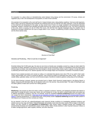
One example of an ecosystem is the coral reef found in tropical climate zones, along shallow coastlines. Coral are small organisms,
fixed in place, that eat by extending their tentacles and snatching food such as small fish and other organisms. Coral are dependent
on the small fish and temperature of the water, as they cannot move if food is no longer available or the temperature becomes
intolerable. However, scientists have identified that global warming has caused ocean temperatures to rise. The result is bleaching
of the coral, which is causing it to die off. When this occurs, the reef that had originally developed along the coastline due to
hardening of excreted material from the coral no longer exists. In turn, erosion, or weathering of Earth’s surface, becomes an issue
and the shore washes away.
Structure of Coral Reef
Glaciation and Weathering ... What is it and why is it important?
Scientists believe that 15,000 years ago, the area we now know as Canada was completely covered by a large ice sheet called the
Laurentide Ice Sheet. Glaciation is the study of ice and its impact on the environment. While it is impossible to know the exact cause
of these large ice sheets, most researchers think that changes in climate caused these sheets to grow. A glacier is simply defined as
a (relatively) permanent body of ice. Glaciers typically move and change shape over thousands or hundreds of thousands of years.
Glaciers have sculpted mountains and carved out valleys. It is estimated that glaciers store about 75% of our earth’s fresh water.
Today, approximately 10% of land is covered by glaciers. They continue to shape our landscape even today. Fjords – long, narrow,
coastal valleys, glaciated valleys, and horns are all erosional types of landforms created by glaciers cutting away at the landscape.
On the North American continent, glaciers are primarily found in Alaska. North America's longest glacier is the Bering Glacier in
Alaska, measuring 204 kilometers long. As the glaciers melt a bit in the summer, they provide water. The state of Washington gets
470 billion gallons of water each summer from melting glaciers!
Weathering
Weathering is the process by which the earth’s surface is exposed to physical, chemical, and biological processes that interact to
wear away or change the land in some way. Rocks, soil, and minerals at, or near, the earth’s surface breaks down and erodes due
to different atmospheric conditions. Acid rain, for example, would be considered chemical weathering because the acidity of the
rain causes the rock to decompose. (Click here for an interesting animation on acid rain from the U.S. Environmental Protection
Agency) Freezing temperatures, or a freeze-thaw cycle, is the primary cause of physical weathering because the water present in
rock expands as it freezes and then contracts as it thaws.
As you learned in the first unit, paleoclimatologists study historical climate conditions by investigating geological evidence and
remains such as tree rings and fossils. Paleoclimatologists will probably never know the exact cause of the ice ages in the Earth’s
history, but they continue to study glaciation and weathering to help monitor today’s changing climate and investigate how
environmental processes and characteristics impact human activity. Better climate prediction is also important because it allows us
to better manage agriculture, water supplies, fisheries, and other resources.
2. For example, scientists have spent a lot of time studying the history of the reversal of oceanic currents in the equatorial Pacific,
commonly referred to as El Niño, because the impact upon the climate has far-reaching effects on human health and safety,
farming, and increased natural disasters across countries in temperate latitudes. Although the effects of El Niño on the climate are
primarily felt in the winter months, the repercussions can be felt in other areas for a much longer period of time. By being able to
predict the El Niño cycle better, scientists hope to lessen the negative impact.
The Impact of Landforms, Bodies of Water and Climate on Human Settlement
Mountain ranges, large lakes and bays, the Atlantic and Pacific Oceans, and intricate river systems all impacted human settlement
throughout the history of North America and continue to do so today. As the European settlers arrived on the east coast of the
United States and began to push into the country, they were blocked by the presence of the large Appalachian Mountain range.
Because there were few passes through this range, these mountains served as a stopping point for most of these early settlers.
They were surrounded by deciduous forests containing a wide array of plants and animals, as well as fertile, well irrigated soil.
Although the work was not easy, these early people were able to harness the power of their surroundings to create successful
settlements.
Thirty-six percent of the North American continent is covered by forests. Forests play an incredibly important role in much of North
America. Forests can be found in a variety of regions and they perform a multitude of functions. Most places with deciduous
forests, (forests that stay green for only part of the year and lose their leaves in the fall), experience four distinct seasons. Forests
provide a habitat for many species of animals; they are a source for timber, and a place used by many for recreation. As you can
see in this image, in a forest, water is stored in tree roots, trunks, stems, and foliage, as well as the soil of the forest floor. This
enables forests to maintain an even flow of water in rivers and streams in times of heavy precipitation or drought – helping to
regulate supplies of drinking water in many parts of the country. When forests are eliminated,desertification can occur, topsoil can
be washed away, and ultimately entire ecosystems might disappear.
When the New World was initially settled by Europeans, the presence of vast forests and intricate river systems helped ensure their
survival.
The Impact of Landforms, Bodies of Water and Climate on Human Settlement
As you learned in the last section, an ecoregion is a large area of land or water that contains a geographically distinct grouping of
natural communities. The continent of North America is home to a variety of ecoregions that stretch between borders and cross
political boundaries. Each ecoregion experiences a slightly different climate. Monitoring soil temperatures are one way that
geologists study the climate of an area. Soil temperatures indicate the heat transfer process occurring at the Earth’s surface that is
causing atmospheric changes. Local topography, the surface features of the earth and sea surface temperatures contribute to
differences in climate between various localities.
Atlantic Canada, for instance, located on the eastern edge of North America, has a climate that is influenced by prevailing westerly
winds. The Prevailing Westerlies are winds found in the middle latitudes between 30 and 60 degrees latitude. Their main role is to
carry the warm waters and winds from the equator to the western coasts of the continents.
In the western portion of the United States, the Sierra Nevada Mountains experience a climate that varies from hot desert (similar
to the Sahara) at its eastern base to an arctic-alpine climateonly a few miles away on the highest peaks. The lakes of the Sierra
Nevadas are very sensitive to the changing climate, due to the fact that they have very extensive bedrock and very little soil.
Occasionally, due to nothing more than gravity, weakened rock on steep slopes suddenly gives way and falls down the mountain
side. The Sierra Nevada Mountains are extensively hiked and explored by people from all over North America and the world.