2. HANGZHOU BAY BRIDGE:
Year of conception : 1994
Construction begin : June 8, 2003
Construction end : June 14, 2007
Opened : May 1, 2008
Project type : Sea crossing bridge
Total length : 35.673km(22min)
Project cost : $16 billion
Project chief designer : Wang renguin
Location : Across the Hangzhou bay on the East China Sea, crossing the Qiantang river at
the Yangtze river delta. Starting in jiaxing to the north, the bridge ends at Ningbo in the south.
Bridge overview : 36km long, 6lane, two-direction highway with 100km/hr speed limit,
100 year guaranteed service design, cable stayed design. The bridge will have two main spans,
with a 448m northern span, and a 318m southern span.
Purpose of bridge :The bridge shortened the highway travel distance between Ningo and
Shanghai from 400km to 280km and reduced travel time from 4 to 2.5 hours
Location of bridge :
Link (1&2)
3. INTRODUCTION
It will not be a hyperbole to say that the rage of being a record holder in a respective field
is tremendously growing day by day and encouraging people to accept the innovative ideas,
techniques, and resources available in the market to fulfill their dreams.
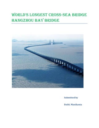
The Hangzhou Bay Bridge is the world’s 4th longest bridge 3rd longest over water bridge and the
worlds longest Trans-oceanic bridge at 22.17 miles long . Spanning across the Hangzhou Bay on the East
China Sea and crossing the Qiantang River at the Yangtze River Delta. It surpassed the Donghai Bridge,
the longest transoceanic bridge in the World, when it was opened in 2005.
The S-shaped Hangzhou Bay Bridge is an important connection in China’s East Coast
Superhighway. Starting in Jiaxing to the north, the bridge ends at Ningbo's Cixi county in the
South.
It shortens the ground transportation distance from Ningbo to Shanghai by 120km and
Travel time from four hours to two and half hours. It is a six-lane, two-direction highway with a
100km/h speed limit, and a 100-year, service guaranteed cable-stayed design.
The Hangzhou Bay Bridge was the main component of a 5.2km national highway between the
Provinces of Heilongjiang in the north and the Hainan in the south. Wang Yong, chief director of the
Hangzhou Bay Trans-Oceanic Bridge Construction Command Post, said the bridge would be one of the
most important, not only in China but in the world "for it is not only the longest one (over a sea) but also
will be built in the world’s most complicated sea environment, with one of the three biggest tides on
Earth, the effect of typhoons and the difficult content of the sea soil".
Link 2
4. Preparatory work started on the bridge as far back as 1994. Construction work began in June 2003
and was completed in June 2007 and an opening ceremony was held on 26 June. Several tests and
evaluations were conducted for about one year before official opening. The bridge was opened to the
public in May 2008 and carried about 50,000 vehicles per day in its first year of operation.
History
The bridge across the Hangzhou Bay was the subject of various feasibility studies for
over a decade before the final plans were approved in 2003. An earlier plan placed the bridge further east,
closer to the mouth of the bay, which provided an even shorter travel distance between Ningbo and
Shanghai. Under this plan, the bridge would begin in the north from, Jinshan a suburb of Shanghai. The
Government of Shanghai rejected the plan and focused on building the 32.5 km (20 mi)-long Donghai
Bridge from Shanghai to its off-shore port at Yangshan in the mouth of the bay. The Shanghai
Government sought to feature Yangshan as the chief port on China's east coast and refused to allow a
Cross-bay bridge to be built on its territory, which would improve access to the port of Ningbo at beilun.
The Zhejiang Provincial Government was forced to build the bridge further to the west on entirely
Zhejiang territory. The Hangzhou Bay Bridge connects Cixi, a local-level city that is part of Ningbo
Municipality, with Haivan, a county in Jiaxing Municipality. The Hangzhou Bay Bridge has significantly
Shortened driving distance between Ningbo and the Yangtze River Delta region and improved the
Competitiveness of the Beilun Port.
NATURAL CONDITIONS
Meteorological Conditions
The Project Area belongs to the typical subtropical zone characterized by a mild, humid,
Link 1
5. rainy climate, frequent monsoons and four different seasons. The annual average temperature is 16c with
the highest temperature of 28c in July and lowest temperature of 4℃ in January.
Landforms
The terrain on the north and south banks at the bridge location is level. The shore consists
of side foreland at river mouth and tidal flats. The south bank is 9 km inwidth while the north bank is 1.5
km in width. The terrain at the bay bottom is composed of scouring channels and tidal current ridges,
rising mildly from east to west with a reduction in water depth. The average and maximum water depths
are 10 m and 13.6 m respectively with a U-shaped trough deeper in the north and more shallow in the
south.
Hydrologic Features
Hangzhou Bay is an informal semidiurnal tidal sea area with flood and ebb tides twice
one day. The flood tide lasts longer than the ebb tide with a typical movement type of reciprocating flow.
The observed maximum tidal velocity is close to 5 m/s, the maximum tidal range is almost 8 m and the
tidal flow volume is about 1 × 10¹⁰ cubic meters. The content of sand and salt in the sea water is
1.25kg/m3 and 10.8 g/kg respectively. Hangzhou Bay is in a stable condition at the bridge location,
Characterized by scour in winter, silting in summer, scour in the north, and silting in the south.
Geological Conditions
The stratum at the bridge location is mainly composed of quaternary cover. It is wildly
covered by quaternary stratum in addition to some buttes and monadnocks on north bank. Thick loose
deposits of the quaternary stratum are mainly composed of clayey soil, sandy loam, muddy loam, silty
link 3
6. sand, fine sand, gravel and medium-fine sand on south bank, with an average thickness of 130 to 220 m.
The stratum belongs to coastal plain. The bedrock is ignimbrite on north bank and mudstone on south
bank.The poor geological conditions are mainly composed of soft soil layer and the methane in shallow
stratum. The soft soil layer is 8 ~ 45m in depth featured with high moisture, high compressibility,
thixotropy-prone, low shear strength, and low capacity. The shallow sandy layer is prone to liquefaction.
The methane in shallow stratum is distributed in lensoid-shaped 40-60 m deep sandy layer in the 10 km
tidal-flat area.
Hydrogeological Conditions
The groundwater is mainly quaternary unconsolidated rock pore water which can be
classified into phreatic water, micro-confined water and confined water at thebridge location. Phreatic
water is mainly distributed in the sandy loam layer at seabottom, of which the first layer phreatic water is
50 m in depth with the sandy loam and fine sand with moisture while the second layer is 80 m in depth
with the medium-fine sand with moisture. The groundwater and seawater are weakly erosive.
Construction challenges
Because of the many difficulties facing such a tremendous build, almost 600 experts
spent nearly a decade designing the bridge. Even after nearly a decade of design, studies, and planning,
many different challenges were encountered, the first being the challenge of offshore construction. As a
solution, several parts of the bridge had to be completed on land and then transported to the area for
which they were built. Some components that were constructed using this process were piers, box girders
(bridge panels), and even the bridge foundations.
Link (3&2)
7. Another construction challenge involved the weather in the region. Wang Yong, chief
director of the Hangzhou Bay Trans-Oceanic Bridge Construction Command Post, described the bridge as
being built in the world's most complicated sea environment, with one of the three biggest tides on Earth,
the effect of typhoons and the difficult content of the sea soil. Erosion of materials and cracking and
Bubbling of any concrete components became a large problem. To combat bubbling and eventual holes,
engineers used a cloth-covered template over the concrete. This would improve the color and density of
the pieces, making them both more aesthetically pleasing and sturdier. To reduce cracking, engineers used
low-strength early-stretching technology when constructing box girders. This technology involves
casting (molding) the girder, or bridge panel, letting it harder for no more than three days, and then
squeezing it before it reaches its full density. This gives the girder more room to stretch after the bridge is
constructed, preventing cracks in the concrete over time.
"severe marine conditions caused difficulties in anchoring barges and construction vessels."
Mostly, construction activity was performed on land and then the prefabricated components were
transported to the site for erection and final installation. For shipping and erecting the girders in sea, giant
floating cranes with accurate anchoring devices and launching gantries were used. Construction on
mudflats near the south shore, in an alternating wet and dry tidal area, presented serious technical
problems. A temporary 10km trestle was erected for pile driving and pier construction. Girders weighing
1,430t were erected from the top, starting from the land end and launching towards the sea. Each
previously erected span served as the deck for transportation and erection of the next girders as the
launching gantry moved forward.
Also, severe marine conditions caused difficulties in anchoring barges and construction
Link 2
8. vessels. Under turbulent tidal flow and typhoon influences, water flow currents were in the range of 2m/s
to 3.32m/s at the Hangzhou Bay Bridge sites. The floating cranes could safely transport the 2,000t girder
from the shore to the site and then anchor stably to erect and install the precast concrete box girder.
The third major challenge faced by designers and engineers was an area of toxic methane gas that
was discovered roughly 50 meters underground below the location of the bridge. No drilling could be
completed before the gas pressure was alleviated. To do this, steel pipes measuring 60 cm in diameter
were inserted into the ground, slowly releasing the methane six months prior to drilling.
MAJOR TECHNICAL CHARACTERISTICS
Large Scale
The bridge is 36 km in total length, of which 35.7 km is bridges over water. The large
scale of the project creates new difficulties for bridge construction, operation, and management.
Poor Natural Conditions
Effective work time is only 180 days per year due to the complicated hydrological and
meteorological conditions with high tide and torrential flow. The geological conditions is comparatively
poor. There are soft soil layers 50 m in thickness and methane in shallow strata within 10 km in the south
shoal, which may have adverse effects on the construction of bridge foundations.
Poor Construction Conditions and Constraints
Construction conditions may be constrained due to the 9 km long tidal-flat area on south
bank.
Link (2&3)
9. Tight Construction Period
The Project is proposed to be completed in 2008. The 70 m full-span prefabricated box girders of the 18
km long approachs have to be erected from water due to the constraints of vessels and equipment while
the 50 m full-span prefabricated box girders of 10 km long approach in the tidal flat section on south bank
must be transported and erected by trolley onto the bridge below. There is only one work face. The
construction plan and organization must focus on making sure the bridge project can be complete in time
even though the offshore operation distance is long and the work load is heavy.
Need for High Structure Durability and Aesthetics
The bridge is in a high erosive sea environment which will have substantial effects on the
durability of bridge. Furthermore, the bridge is located in the highly developed economical district in the
Yangtze delta, so a high standard of aesthetic design is required.
Architecture, design and structure
The Hangzhou Bay is a gulf in the East China Sea where one of China's natural
wonders, the Qiantang River Tide, creates fast water and large waves. The area is also a typhoon
prone zone. These factors made construction feasibility a major concern for the project and the plan was
only finalised after nine years of consultation and over 120 technical studies with the help of more than
700 experts from throughout the world.
The cable-stayed bridge design was selected for the project as it can withstand the
Link (2&3)
10. adverse conditions, multi-directional currents, high waves, and geologic conditions at the site. The bridge
structure has also been designed to seismic criteria and will retain integrity in earthquake conditions up to
seven on the Richter scale.
The 36km length has highway-class road with six, 3.75m lanes, three in each direction. The
overall width of the bridge is 33m. The roadway grade at cross-slope is 2% and a maximum 4% at
longitudinal slope.Designed for 100 years of service life, the bridge has speed limits of 100km/h for the
main spans and 120km/h for land approaches. The bridge has a height of 62m, enabling fourth and fifth
generation container ships to pass through in all conditions. The total length of cable used in the project is
32.2km.
Layout and structure
The Hangzhou Bay Sea-crossing Bridge is a component of the national trunk line in
thehighway network of China’s “Five and Seven arteries in south-north andeast-west directions”. It
provides the most convenient way across the Hangzhou Bay on the highway from Shenyang to Haikou.
The bridge is also an important component of highway network proposal of “2 transverse and longitudinal
trunk lines separately, 18 link roads, 3 loop highways and 3 road corridors” before 2010 in Zhejiang
province, and thus will effectively connect the southeast cities of Ningbo and ZhouShan of Zhejiang
province with Shanghai to reduce driving time to under two hours.
The Hangzhou Bay Bridge consists of nine sections. The first is the bank lead road to the north approach.
Link (2&3)
11. The north approach rests on low piers with post-tension concrete box-girder spans spanning pre-stressed
continuous concrete box-girders and drill-shaft pile. The north approach leads to the north navigable
bridge; a cable-stayed bridge with twin diamond-shaped towers, double cable and steel box-girders. The
main span of the north approach is 448m. Including side spans, the total length is 908m.
The north high piers have continuous, 70m, post-tensioned, concrete box-girder spans with a total length
of 1,470m.
The middle bridge approach is laid on low piers with 70m, post-tension, concrete box-girder spans with a
total length of 9,380m.
The south navigable bridge is a cable-stayed bridge with an A-shaped single tower, double-cable and steel
box-girders. The main span is 318m, and the total length including side spans is 578m.
The south high piers have continuous 70m, post-tension, concrete box-girder spans with a total length of
1,400m.
The eighth section measures to a total of 19,373m, and is composed of three sections:
6,020m in-water section with 70m girders and steel piles.
10,100m mud-flat section with 50m girders and drill-shafts.
3,253m land section with 30m to 80m girders and drill shaft foundations
The ninth section is Bank Lead Road at the south approach.
Protecting the Hangzhou Bay Bridge
Link 2
12. The Hangzhou Bay Bridge, which spans the East China Sea, is constructed of concrete
and steel. Silicone water repellents were selected to protect this important landmark from salt water
corrosion, which could damage the structure and deteriorate its appearance. Silicone water repellents
penetrate the pores of concrete and make the surface more resistant to water penetration.
Global positioning system
Trimble provided Global Positioning Systems for the monitoring of the construction. The
project required precise positioning for the bridge span off the coast. By using the Trimble 5700 RTK
GPS systems with a reference station for differential corrections, accuracy was improved at longer
distances enhancing the productivity.
A total of 50 5700 RTK GPS systems were set up where the bridge crosses the Bay of
Hangzhou and additional systems were located on barges in order to provide millimeter accuracy for the
Real-time positioning of piles and pre-fabricated sections of the bridge.
Auxiliary facilities and structures
At the middle of the bridge, a 10,000m² service island is planned for drivers to rest and
enjoy a full range of services, including hotels, restaurants, petrol stations and a viewing tower. It is also
expected the service island will become a tourist destination for watching the Qiantang River Tide. The
service island will be built entirely on piers to avoid disrupting the tide. Two public parks are also
planned on each side of the bridge.
Link (2&4)
13. The bridge required the installation of traffic safety devices, monitoring systems,
communications equipment, toll plazas, power supply, lighting and maintenance and office buildings.
The service centre was slightly damaged in a fire on the March 23, 2010 but opened to tourists
on December 19, 2010.
Investment partners
"Construction of the sea-crossing bridge is an indication of China’s increasing
economic power, and it is expected to boost economic development in the Yangtze River Delta."
Of the total project cost of CNY11.8bn ($1.42bn), approximately CNY149m ($18m) was
contributed by 17 non-governmental enterprises in the province. Around 35% of this amount was raised
from private companies in Ningbo; 59% was provided as loans from China’s central and regional banks.
Link 2
14. The Songcheng Group is the biggest non-governmental shareholder in the project with its investment
accounting for 17.3% of the basic capital. Construction of the sea-crossing bridge is an indication of
China’s increasing economic power, and it is expected to boost economic development in the Yangtze
River Delta, also called the Golden Industrial Triangle. The officials expect to recover the capital costs of
the project in 15 years.
Lv Zushan, Governor of Zhejiang, China’s fourth-largest provincial economy said: "The
bridge will help form a more convenient and efficient traffic network in the Yangtze River Delta,
enabling each part to develop much closer relations with one another… We believe the bridge will open
many more opportunities for the region’s overall development and greatly enhance its economic strength
and competitive power."
Contractors
China Railway Bridge Bureau Group Co. Ltd. was the main contractor for the project.
The contract for consulting and engineering services was awarded to Hardesty & Hanover, LLP. ICE
participated in the project by the use of three ICE V360 tandem vibratory pile drivers to produce the
foundations for the bridge in the middle of Hangzhou Bay. Ty Lin International was the designer of the
bridge. Ben C Gerwick provided ship impact protection systems for the bridge.
CONCLUDING REMARKS
The economic benefits brought by the Hangzhou Bay Bridge is enormous," said Huang
Link (2&5)
15. Renwei, vice president of the Shanghai Academy of Social Sciences. It is estimated that savings in
transportation cost and time in southern Zhejiang will amount to Rmb40 billion to Rmb50 billion and
Rmb10 billion respectively within 10 years of the opening of the bridge
The Hangzhou Bay Bridge is a large-scale project with complex construction conditions.
The primary material quantities are given in Table 1. The exploration and design work was carried out by
a joint venture of CCCC Highway Consultant (HPDI) Co., Ltd (General design, north channel bridge,
south channel bridge, approaches in the high pier region, and offshore platform design) and China
ZhongTie Major Bridge Reconnaissance and Design Institute Co., Ltd (approaches in the low pier region
and link road design).
Reference :
Link1 : Wikipedia
Link2 : http://www.roadtraffic-technology.com/projects/hangzhou/
Link 3 : paper(pdf) Wang RENGUI Civil Engineer CCCC Highwang Consultants CO. Ltd. 85,
Deshengmenwai Street,Xicheng District,(100088) Beijing CHINAwrengui@263.net
Link 4: http://www.dowcorning.com/content/discover/success-hangzhou-bridge.aspx
Link 5: http://www.hktdc.com/info/mi/a/bacn/en/1X002EZV/1/Business-Alert-%E2%80%93-
China/Hangzhou-Bay-Bridge-Spurs-World-s-Sixth-Largest-City-Cluster.htm
Link (2&5)