Digimap Essentials
•Download as PPT, PDF•
2 likes•1,507 views

Slides used in Digimap Collections training courses in April 2013. Digimap Collections provides mapping data of GB to licensed UK educational institutions. Slides given an introduction to the Collections, then cover Digimap Roam mapping service plus the Data Download service.

Recommended
Recommended
More Related Content
What's hot
What's hot (20)
Viewers also liked
Viewers also liked (20)
Similar to Digimap Essentials
Similar to Digimap Essentials (20)
More from EDINA, University of Edinburgh
More from EDINA, University of Edinburgh (20)
Recently uploaded
Recently uploaded (20)
Digimap Essentials
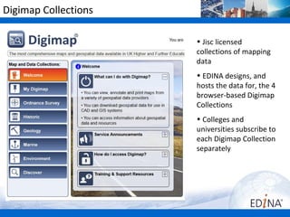
- 1. Digimap Collections • Jisc licensed collections of mapping data •Colleges and universities subscribe to each Digimap Collection separately http://www.jisc-collections.a • EDINA designs, and hosts the map data for, the browser-based Digimap Collections: http://edina.ac.uk/
- 2. Copyright and Terms of Use In summary: • maps produced from Digimap Collections are for Teaching, Educational Research or Academic Research by registered users. • there are some restrictions on the size and form of publication of maps from Digimap. • copies may be made of maps printed from Digimap providing they are required for Teaching, Educational Research or Academic Research purposes. All copies must continue to show the copyright acknowledgement. • all maps must carry an appropriate copyright acknowledgement, for example: "© Crown Copyright/database right 20(yy). An Ordnance Survey/EDINA supplied service."
- 3. Copyright and Terms of Use • Guidance on the licence agreements: http:// digimap.edina.ac.uk/webhelp/digimapsupport/access/licence_agree
- 4. OS licence • Variation agreement to original sub-licence expired 2011 • JISC Collections has made progress with negotiation and the OS has agreed to cap the liabilities they seek from subscribing institutions • There will be an End User Licence Agreement - work is on- going to make this as simple for the user as possible
- 5. OS Open Data ‘Create and support innovative, exciting ideas and applications using our mapping. With OS OpenData you can freely access a selection of the most detailed mapping datasets available for Great Britain.’ http://www.ordnancesurvey.co.uk/oswebsite/products/os-opendata.ht •Digimap OS Collection provides some of the OS Open Data sets – different terms and conditions apply to this data (can be used commercially). •When users download OS data from Digimap, a conditions document is included, which specifies if data is: – covered by Digimap licence – Covered by Open Data licence
- 6. Digimap’s Ordnance Survey Collection View and print PDF maps Download map data Query tools
- 7. Digimap’s Ordnance Survey Collection •Roam – fixed scale mapping. • 14 zoom levels, or views. • Each view uses an OS map data product, appropriate for that scale. • Print A4 to A0 PDF. • User can select print scale. •Carto – user selects scale of map. Print A4 to A0 PDF. To be withdrawn July 2013.
- 8. Roam
- 9. Historic Digimap Ancient Roam – timeline allows you to view maps from different decades Access to land use maps from 1930s. Historic Download tool – download 3 different map series
- 10. Ancient Roam
- 11. Historic Download Pre-National Grid maps •Town Plan maps at 1:500, 1:528 and 1:1056 scales published from 1848 and 1939, for towns with a population in excess of 4000 at the time of survey, •County Series maps at 1:2500 and 1:10560 scales published between 1846 and 1969, National Grid maps •National Grid maps at 1:1250, 1:2500 and 1:10560/10,000 scales, published from 1948 – 1996 •All maps in TIFF image format.
- 12. Map revisions • A map series covers a time period, for example the County Series 1:10560 series ran from the 1840s to the 1960s. • Within that time period, areas were resurveyed periodically and maps were revised. • Not all areas were resurveyed, only those with significant change. •2nd revision 1900 – 1949 •Maps available in blue areas (note this map availability tool is in Historic Download)
- 13. Geology Digimap Geology Roam – view British Geological Survey with OS maps as background Download geological map data – 4 map products available
- 14. Geology Roam
- 15. Geology Digimap Download •4 data sets available, in 2 formats •Can select to download layers of interest only
- 16. Marine Digimap 2 mapping facilities – 2 different map data sets. Both based on Admiralty Charts 2 data download facilities
- 17. Hydrospatial Data • Vector data product from SeaZone, designed for use in a GIS: http://www.seazone.com/dataHydroSpatial.php • Used to create online maps in Marine Roam, within Marine Digimap. • 7 Topic Layers – each layer has themes. • Data is collected at various scales, the best available for each source. • Projected in WGS84 not British National Grid. • Available in 2 formats - Shapefile (for ArcGIS), MapInfo Tab. • Last updated in Marine Digimap in 2011.
- 18. Marine Roam
- 19. Marine Digimap Hydrospatial Download
- 20. Charted Raster Data • Raster data product, used to create online maps in Marine Maps within Marine Digimap. • Scanned Admiralty Charts covering the UK and the surrounding seas from 1:3.5million to 1:2,500. • Data supplied as GeoTiff images, ready for use in a GIS. • Each map has its own projection, referenced to the Horizontal WGS84 Datum. • These data make ideal backdrop maps, but must NOT be used for navigation. • Last update to data in Marine Digimap in 2005.
- 21. Marine Maps
- 22. Marine Digimap Charted Raster Download
- 23. Environment Digimap In development. Info. about subscription and access to the service will be published when available.
- 24. Environment Digimap • Land cover data from Centre for Ecology and Hydrology, NERC centre http://www.ceh.ac.uk/LandCoverMap2007.html • Land Cover maps for 1990, 2000 and 2007 will be displayed in Environment Roam • Environment Roam available initially • Data download service will follow
- 25. Environment Roam
- 26. Fieldtrip GB Open data mashup http://fieldtripgb.blogs.edina.ac.uk Coming Soon…..
- 27. Authentication • No separate login page • Users can choose to login via UK federation, or to Explore Resources
- 28. User registration • Individual registration required for Digimap OS, Geology Digimap and Marine Digimap • Can register for more than one collection on same form • Approval process takes between 24 hours and 2 working days • User email must be correct and current (does not have to be institutional email)
- 29. User details • Users can change details in My Digimap area • Essential to keep email address updated, to receive data download links and info. on downtime, service updates etc
- 30. Content • View, annotate and print maps – Scale – Roam
- 31. Scale • The ratio between distance measured on the map and the true distance on the ground • Scale may be expressed in several ways: – as a Representative Fraction • e.g. 1:1,250; 1:250,000; 1:63,360 • “One unit on the map represents 1,250 units on the ground” – in words • e.g. “one inch to one mile” • “One inch on the map represents one mile on the ground” – by scale lines 0 50 100m
- 32. Scale • Large scale or small scale? – Relative terms
- 33. 1:625000 scale • Very small scale • 1cm on map = 6.25 km on ground • 1” = 10miles • Paper equivalent – Great Britain Route Map Source: http://www.ordnancesurvey.co. uk/oswebsite/gi/chooserightma p/scale625000.html
- 34. 1:250000 scale • Small scale • 1cm on map = 2.5km on ground • 1” = 4 miles • Paper equivalent – road maps • Source: http://www.ordnancesurvey.co .uk/oswebsite/gi/chooserightm ap/scale250000.html
- 35. 1:50000 scale • Small scale • 1cm = 500m on ground • 11/4” = 1mile • Paper equivalent – OS Landranger map Source: http://www.ordnancesurvey.c o.uk/oswebsite/gi/chooseright map/scale50000.html
- 36. 1:25000 scale • Medium scale • 1cm = 250m on ground • 21/2” = 1mile • Paper equivalent – OS Explorer maps • Source: http://www.ordnancesurvey.c o.uk/oswebsite/gi/chooseright map/scale25000.html
- 37. 1:10000 scale • Mid-scale • 1cm = 100m on ground • 61/4” = 1mile • Digital map products – – Streetview – OS VectorMapLocal – 1:10000 raster • Source: http://www.ordnancesurvey.co. uk/oswebsite/gi/chooserightmap /scale10000.html
- 38. 1:1250 scale • Large-scale • 1cm = 12.5m on ground • 50” = 1 mile • Digital map products – OS MasterMap • Source: http://www.ordnancesurvey. co.uk/oswebsite/gi/chooseri ghtmap/scale1250.html
- 39. Roam Map tools: hill shading, measure, annotate, print Hints & Tips Task menu: Map panel Search, Map Content, Map Info, My Maps
- 40. Roam - Local view
- 41. Street View
- 42. Plan View
- 43. Roam • Some views customisable, can select which features to display • Search options: full postcode, place name, grid reference • Slippy maps – click and drag • Print in PDF format - A4-A0, landscape or portrait • Select print scale, within sensible limits (depend on map being displayed) • Copyright statement included on PDF file
- 44. Search – Place name Local view map returned
- 45. 1:50000 Scale Gazetteer • Place name search uses the OS 1: 50000 Scale Gazetteer • Same database that is used on OS Landranger Map • No street name searching possible
- 46. Search - postcode Street view map returned
- 47. Search – 100 x 100 km OS tile Regional view SE
- 48. Search – 4 figure grid reference Metropolitan view SE4182
- 49. Search – 6 figure grid reference Local view SE416820
- 50. Learn more on Grid Referencing… • Ordnance Survey resource: http://www.ordnancesurvey.co.uk/oswebsite/education-and- research/teaching-resources/using-the-national- grid/index.html • Digimap eLearning module
- 53. Navigation • Zoom in/out – Fishbone – Double click to zoom in – Scroll wheel on mouse • Pan – Click and drag the map – Compass • Full extent / Previous / Next views
- 54. Map Content Control • Allows the user to customise the features they see on the map, e.g. remove water features, or road features • Available in 8 views: • Metropolitan View • City View • District View • Neighbourhood View • Street View • Detailed View • Plan View • Building View
- 55. Map Content Control List of layers
- 56. Map Content Control Uncheck boxes to remove layers
- 57. Map Content Control • OS maps used in Roam are Vector or Raster map data. • Not possible to select individual features in raster maps.
- 58. Themes • Themes / alternatives styles available in 5 most detailed views: Neighbourhood, Street, Detailed, Plan, Building • Found within Map Content Control - Theme
- 59. Alternative map styles • In Map Content Control, user can select a theme • Used a map data product from OS OpenData to create these themes – OS VectorMap Local • http://www.youtube.com/user/EDINADigimap#p/a/u/1/wad gUWe3jNA
- 60. Map Information Map product, coordinates, print scale
- 61. My Maps • Click Save current map, enter a Map title, Click Ok • Available whenever you login
- 62. Measurement tools • Click the distance tool to activate • Click at each point on the map – a pink line is added • Double click at last point • Distance given in tools box
- 63. Measurement tools • Click the area tool to activate • Click at each point of your area – a pink shaded area is added • Double click at last point • Area given in tools box
- 64. Annotation tools • Tools to add lines, shapes, text and labels to your maps
- 65. Annotation tools • Toolbar appears at the top of the screen – can be moved around • Main options to add annotations in the Draw & Create area – add symbols, text, lines, polygons, pre-defined shapes • Annotations remain on your map at the same scale as you zoom in and out
- 67. Annotations options • Save annotations within Digimap (can retrieve and display annotations in any Roam service e.g. Ancient Roam) • Make visible on PDF print • Export formats: Shapefile, KML, GeoJSON • Import formats: Shapefile, KML, GPX, CVS, GeoJSON
- 68. Annotation import • Import Shapefiles, KML, GPX, CSV and GeoJSON datasets. • In this example we uploaded a Shapefile • Location of operational wind farms in GB
- 69. Hillshading • Off by default – click Hill icon to switch on
- 70. Hillshading • Uses Ordnance Survey Digital Terrain Modelling map to shade elevated areas
- 71. Print • opens in new window, move map around in preview • add gridlines, annotations, title, hillshading • select print scale • print A4 to A0 landscape or portrait • PDF, PNG or JPG
- 72. PDF print
- 73. Roam practise • Login to Digimap: http://digimap.edina.ac.uk/ • Select EDINA as your institution • Use username and password on your training guide Create and save these maps: 1. Plan view of Newcastle University campus, NE1 7RU. Select a Line Drawing theme. 2. Metropolitan view of London, with City of London at the centre. Remove all roads except motorways and A roads. 3. Local Plus view map with Snowdon (Gwynedd) at the centre, with Hillshading on.
- 74. Annotations practise - recreate this map
- 75. Annotations practise 1 • Map of the site for a proposed new hotel and retail development in central Edinburgh – Search with a postcode, EH1 1JF – Zoom in to Plan View – Centre the map where Cowgate meets South Bridge TIP: very slightly north of Museum and Univ building – Select Line Drawing Theme – Add a polygon that covers the empty site – Add labels for Hotel entrance and Retail Development
- 76. Content • Download map data from Digimap – What data is available? – OS Data Download service
- 77. Data Download services • Users can download a wide range of OS map data products in Data Download • MasterMap Download is for OS MasterMap data in GML (vector) format • Boundary Download provides OS postcode and boundary lines From 5th Feb, all available in Data Download – all 3 services will continue to be available until end of May 2013.
- 78. Updated data • Used to be one annual update - now update data more regularly • Select preferred version in Data Download
- 79. Available datasets and dates http://digimap.edina.ac.uk/webhelp/os/data_information/os_data_issues/os_update _dates.htm#
- 80. Data Download service, 3 step process 1. Select area 2. Select maps 3. Add to basket (options) 4. Download several map products in one order
- 81. Basket options • Click Change to select format, map date and layers • Options available depend on the map product
- 82. Vector data formats Format Compatibility SHP Shape file, ArcGIS format MIF/MID MapInfo format NTF National Transfer format, non-proprietary GML Geography Markup Language DXF Drawing Exchange Format, AutoCAD
- 83. Issues for Digimap users • Compatibility - some vector map data formats available from Digimap may not be compatible with your GIS/CAD software • Styling of data – vector map data downloaded from Digimap will not have a cartographic style, when viewed in GIS/CAD
- 84. Formats and conversion guidance http://digimap.edina.ac.uk/webhelp/os/data_information/data_formats/new_data_tran slators.htm
- 85. Data Download • Data Download has 5 categories of data • Click + or on Category name to open
- 86. 1. OS MasterMap • Most detailed mapping available of GB • Ordnance Survey have 4 layers of MasterMap data (Topography, Imagery, ITN and Address Layer) • Digimap offers two of these layers: • Topography layer • Integrated Transport Network (ITN) layer • Change Only updates available
- 88. OS MasterMap Topography data http://www.ordnanc esurvey.co.uk/osweb site/products/os- mastermap/index.ht ml
- 89. Using OS MasterMap in ArcGIS • OS MasterMap supplied in GML format (within a Gzip file) • Can import this directly to ArcMap…but In our experience it is trickier to isolate features, analyse the data, change the style when using this method. We recommend that you convert the data if possible. • Conversion options?
- 90. OS MasterMap conversion Possibilities: 1. Convert to ESRI Geodatabase format using Productivity Suite (ArcGIS V9.2 or later) or Map Manager (ArcGIS V9.1 or earlier) 2. Convert to Shapefile format using InterpOse
- 91. OS MasterMap Convertor • Available through Eduserv CHEST: • ESRI Productivity Suite (ArcGIS V9.2 or later) • Map Manager (ArcGIS V9.1 or earlier) • Converts OS MasterMap data to ESRI Personal Geodatabase format • Accepts GZip files for conversion
- 92. InterpOse Digimap edition http://www.dottedeyes.co.uk/spatial_data_loading/interpose/digimap.php • Free download, which converts MasterMap GML data to SHP file format (and various other formats) • InterpOse accepts GZip files for conversion
- 93. 2. Backdrop mapping •Largest scale at top •Raster data all supplied in TIFF image format, with a TFW file •TIFF World Files contains location, scale and rotation of TIFF map. Keep in same folder as TIFF •All compatible with ArcGIS, no conversion requirements
- 94. 2. Backdrop mapping • Information boxes indicate: – Scale – Format availability – Version – Data Allowance – Terms of use • Version and format can be changed in order Basket, under options
- 95. 3. Land and Height data •PROFILE 1:10000, created 2009. Contours at 5m intervals with spot heights. •PANORAMA 1:50000, created 1996. Contours at 10m intervals with spot heights. •DTM – Digital terrain model – 3D representation of terrain surface.
- 96. 3. Land and Height data • Contours, Panorama available in DXF, NTF formats • DTMs available in DXF, NTF, ASC, TIFF • DXF AutoCAD format, can import to ArcGIS but… • NTF can be converted to ESRI Geodatabase, with Productivity Suite
- 97. Productivity Suite, NTF Convertor • Converts NTF data to ESRI Personal Geodatabase
- 98. 4. Vector Data • Formats available for products not consistent, e.g.: – VectorMapLocal – GML – Strategi – SHP, DXF, TAB, NTF, MIFMID • SHP available for all vector maps, except VectorMapLocal and Meridian 2 Tiles (NTF, DXF)
- 99. Vector data formats Format Compatibility SHP Shape file, ArcGIS format MIF/MID MapInfo format NTF National Transfer format, non-proprietary GML Geography Markup Language DXF Drawing Exchange Format, AutoCAD
- 100. Shape files • Shape files do not require any conversion prior to use in ArcGIS. • Remember to keep all constituent parts together - SHP, DBF, SHX:
- 101. OS VectorMapLocal • Free convertor – GML to SHP – from Rolta • http://www.rolta- europe.com/osvecto r.html • Digimap will start to supply VML in SHP in near future
- 102. 5. Boundary and Location Data • Boundary-Line - administrative boundaries e.g. counties, unitary authorities, electoral areas • Code-Point – coordinates for postcodes, boundaries for postcodes • OS Locator – gazetteer of road names • Entire 1:50000 Scale Gazetteer, 260,000 entries • National Grid square outlines, 1km, 5km, 10km, 20km, 100km options • GB National outlines
- 103. OS Boundary-Line • SHP, MIFMID formats available
- 104. Code-Point • Code-Point data, on 1:10000 Scale Raster background •Available in CSV or NTF format. Simplest to import to ArcGIS using CSV.
- 105. Code-Point with Polygons • Code-Point polygons are digital post-code boundaries • Image shows Code-Point data and Code-Point Polygons, on 1:10000 Scale Raster background •Available in SHP or MIF/MID format
- 106. 1:50000 Scale Gazetteer • Place name searches in Digimap use the OS 1: 50000 Scale Gazetteer • Same database that is used on OS Landranger Map • Download entire Gazetteer from Data Download, CSV format
- 107. Gazetteer Plus • Or download selected records using Gazetteer Plus – CSV, TAB or XML formats
- 108. Gazetteer data • Delivered in CSV file • In order to import to ArcGIS, saved as DBF IV, using Excel 2003 • N.B. DBF IV option not available in Office 2010 – try Open Office spreadsheet
- 109. Content • Download map data from Digimap – What data is available? – OS Data Download service
- 110. Data Download • Step 1 – Select area • Step 2 – Select data • Step 3 – Add to Basket
- 111. Data Download
- 112. Options • Some map data products have more than Format option or Version, or a selection of Layers • Change the default selections within your Basket:
- 113. Data Download • Sample options
- 114. Preview Area • Receive all intersecting National Grid tiles covering the selected area • Likely to receive data for a larger area than the one selected • National Grid tile sizes: – 1 x 1 km, 5 x 5 km, 10 x 10 km, 20 x 20 km, 100 x 100 km
- 115. Link to collect data
- 116. Collect data
- 117. Data Download • Order data for the area around Newcastle University (NE1 7RU) or an area of your choice: 1. OS MasterMap Topography, December 2011 version 2. 1:10000 raster, June 2011 3. Profile DTM, TIFF format 4. VectorMap District 5. Boundary-Line – SHP format, County boundaries only
- 118. Unzipping standard Digimap zip files • Standard Windows unzip facility will extract the data from the zip file:
- 119. Unzip standard Digimap zip files • Sub-folder for each map product • Citations and contents text documents at top level
- 120. Sub-folder contents • This example is a raster map data product. Note TIFF file and TFW files. • Conditions of use text file. Data from Digimap OS is covered by the Digimap licence OR the OS OpenData licence. So each data folder has a conditions document that specifies which conditions apply.
- 121. Unzip MasterMap zip files • Data is delivered in GZip file - GML data within the GZip • Can extract the GML file from the GZip file…not always necessary to do this. Use WinZip, 7Zip, GZip to extract from GZip
- 122. Styling vector data • Vector data (e.g. OS MasterMap, OS VectorMap Local) will not have the same appearance as it does in Digimap, when initially added to ArcMap
- 123. Styling options • Options for cartographic styling in Symbology tab of map layer properties 1. Generate your own style using layer attributes 2. Apply a layer file that contains styling information 3. Match to symbols in a pre-installed style
- 124. OS MasterMap symbology • Productivity Suite, Map Manager – symbology files available with the evaluation software: – http://www.esriuk.com/software/arcgis/productivitysuite/download#
- 125. Digimap help pages
- 126. OS MasterMap symbology • InterpOse – provide a style file for ArcGIS, which you select to install.
- 127. EDINA Symbology, or style, files • OS vector data: – Strategi, Land-form Panorama, Meridian, Land-Line – in OS help: – http://digimap.edina.ac.uk/webhelp/os/using_data_with_arcgis/using _ntf_data/symbology_in_arcgis_9.htm • Geology Digimap – bundled with data download file. 1 avl file for each Shape file. • Marine Digimap – download Fonts files and Style file from Marine Digimap Help pages and copy into relevant folders in C:/Program Files.
Editor's Notes
- Topography Layer is a detailed, intelligent, geographic database. It contains almost half a billion features from the built and natural landscape of Britain. Detailed and surveyed to a high degree of accuracy, the Topography Layer is continually revised to incorporate changes to the urban and rural environment. It consists of nine themes: land area classifications; buildings; roads, tracks and paths; rail; water; terrain and height; heritage and antiquities; structures; and administrative boundaries. The ITN Layer is a detailed, accurate and up-to-date digital dataset consisting of a Roads Network theme and a Road Routing Information (RRI) theme for Great Britain. The Roads Network contains road categories, from motorways and primary routes to named and unnamed minor roads and local streets. RRI contains features such as height, weight and width restrictions; traffic calming; turn restrictions; and one-way roads as well as vehicular access and time restrictions. Other OS Layers – not available within Digimap Address Layer The most complete national address dataset for the whole of Great Britain. Imagery Layer The OS MasterMap Imagery Layer is a maintained dataset of high-quality aerial photography and provides a detailed aerial map of Great Britain.