SlideShare a Scribd company logo
1 of 9
Download to read offline
Convert AutoCAD .dwg files to .shp files:
Making a CAD .dwg file readable in GIS, georeferencing it to
the existing .shp files and converting it to a .shp file.
Part 1: Opening and Georeferencing a .dwg file in ArcMap
1. Start with ArcMap and a shapefile of the area you are trying to match to
your .dwg drawing.
You will need to know the exact coordinates of two points on this existing
.shp file so you can “stretch” or adjust the CAD drawing to match these two
points.
2. You will likely need the full version of ArcGIS (ArcMap) and not the
educational trial version as you will need to utilize the Georeferencing tool.
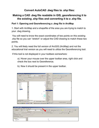
If this tool is not displayed in your toolbars somewhere:
a). Hover your mouse over the upper toolbar area, right click and
check the box next to Georeference.
b). Now it should be present in the upper toolbar.
3. Add the .dwg file just as you would add any other .shp file.
You will get a message box that tells you that you can add the drawing, but
it is not projected. Click OK.
4. Go to the Layer tool (of the Georeferencing toolbar) and select the
polyline, point or polygon option in the drop down menu. (This selection
depends on what you are georeferencing. In this tutorial we are working
with polygons.)
5. In the ArcMap Layers display, select your .dwg file. Make sure your map
is zoomed to about the area where you want to fit your .dwg file.
In the Georeferencing toolbar, select Fit to Display.
This will bring the .dwg immediately over the existing .shp file, though they
will not match up yet…but at least you can see it's in the neighborhood.
Now you are ready to georeference the .dwg file.
6. Click on the icon in the Georeferencing toolbar that has two little x’s, one
green and one red…connected by a small line.
You will use this tool to match two points on the .dwg with two points on the
.shp file.
7. In this tutorial there is a shapefile with two points that correspond with
two corner points of polygons on the .dwg file.
Once you select the tool, your mouse will be a crosshair:
a).Click on the first point to line up on the .dwg layer.
b).Click on the point that matches on the shapefile.
(Zoom in and pan as needed to get more accurate with selecting
these points.)
c). Repeat this with the other points. Ideally, you would do this for two
or more points at opposite corners of the drawing. Less than two can
warp or distort the CAD drawing and reduce the accuracy.
8. Once you have all your points selected with the crosshair tool, select
“Update Display” from the Georeferencing dropdown list.
9. You may want to zoom in on the points you used to align the CAD file
and insure they are lined up. Repeat steps 6-8 until you are satisfied with
the alignment of your .dwg with the rest of your .shp files.
Note: You will notice on the example that
ArcMap imported all the layer types that existed
on the .dwg file. If there are layers you do not
want, click on the box with a plus sign next to the
.dwg listing in the ArcMap Layer display.
Uncheck the CAD layers you do not want. In this
case, the Annotation layer includes the text from
CAD. Uncheck to turn off the text.
Part 2: Convert a .dwg file to a .shp file.
1.Right click on the layer within the .dwg file you want to convert.
Select “Data”. Select “Export Data”.
2. In the “Export Data” window, the default to Export is “All Features”. You
should not have to change any of the other settings except for a place to
save the new file.
Select the folder icon.
Browse to where you want to save the new shapefile.
Name the shapefile. Select Save.
Select OK in the “Export Data” window.
3. A window will open to ask if you would like to add the exported data to
the map as a layer. Select Yes.
Your new shapefile will open onto the map. Now you may remove the .dwg
file from the Layer display.

More Related Content

What's hot

Koreksi Geometrik, Digitasi Peta dan Pengisian Tabel Atribute
Koreksi Geometrik, Digitasi Peta dan Pengisian Tabel AtributeKoreksi Geometrik, Digitasi Peta dan Pengisian Tabel Atribute
Koreksi Geometrik, Digitasi Peta dan Pengisian Tabel AtributeAzmi Rahman
 
Makalah kuljar (amrullah m) PERBANYAKAN JERUK SECARA IN VITRO
Makalah kuljar (amrullah m) PERBANYAKAN JERUK SECARA IN VITROMakalah kuljar (amrullah m) PERBANYAKAN JERUK SECARA IN VITRO
Makalah kuljar (amrullah m) PERBANYAKAN JERUK SECARA IN VITROSMPN 4 Kerinci
 
Analisa Usaha Tani Budidaya Kacang Panjang
Analisa Usaha Tani Budidaya Kacang PanjangAnalisa Usaha Tani Budidaya Kacang Panjang
Analisa Usaha Tani Budidaya Kacang PanjangMuliadin Forester
 
tembang macapat materi kelas 11 - clarisa cecilia
tembang macapat materi kelas 11 - clarisa ceciliatembang macapat materi kelas 11 - clarisa cecilia
tembang macapat materi kelas 11 - clarisa ceciliaclarisacecilia
 
Perkawinan dihibrid
Perkawinan dihibridPerkawinan dihibrid
Perkawinan dihibridJeneng Omega
 
Pengukuran dan Pemetaan Hutan
Pengukuran dan Pemetaan HutanPengukuran dan Pemetaan Hutan
Pengukuran dan Pemetaan HutanlombkTBK
 
Hasil Hutan Bukan Kayu
Hasil Hutan Bukan KayuHasil Hutan Bukan Kayu
Hasil Hutan Bukan Kayuzuhryharyono1
 
Kumpulan Teks Anekdot
Kumpulan Teks AnekdotKumpulan Teks Anekdot
Kumpulan Teks AnekdotFirdika Arini
 
10.monitoring dan evaluasi penggunaan lahan dan kelembagaan p das
10.monitoring dan evaluasi penggunaan lahan dan kelembagaan p das10.monitoring dan evaluasi penggunaan lahan dan kelembagaan p das
10.monitoring dan evaluasi penggunaan lahan dan kelembagaan p dasZaidil Firza
 
Undang-undang No. 18 Tahun 2008 tentang Pengelolaan-Sampah
Undang-undang No. 18 Tahun 2008 tentang Pengelolaan-SampahUndang-undang No. 18 Tahun 2008 tentang Pengelolaan-Sampah
Undang-undang No. 18 Tahun 2008 tentang Pengelolaan-SampahJoy Irman
 
Operasi dan pemeliharaan
Operasi dan pemeliharaanOperasi dan pemeliharaan
Operasi dan pemeliharaanIsti Ana
 
Laporan Praktikum Sosiologi Pertanian
Laporan Praktikum Sosiologi PertanianLaporan Praktikum Sosiologi Pertanian
Laporan Praktikum Sosiologi PertanianAgus Wahyuda
 
Penataan lahan
Penataan lahan Penataan lahan
Penataan lahan Noveriady
 

What's hot (20)

Naskah drama
Naskah dramaNaskah drama
Naskah drama
 
Faktor erosi topgrafi
Faktor erosi topgrafiFaktor erosi topgrafi
Faktor erosi topgrafi
 
Koreksi Geometrik, Digitasi Peta dan Pengisian Tabel Atribute
Koreksi Geometrik, Digitasi Peta dan Pengisian Tabel AtributeKoreksi Geometrik, Digitasi Peta dan Pengisian Tabel Atribute
Koreksi Geometrik, Digitasi Peta dan Pengisian Tabel Atribute
 
Makalah kuljar (amrullah m) PERBANYAKAN JERUK SECARA IN VITRO
Makalah kuljar (amrullah m) PERBANYAKAN JERUK SECARA IN VITROMakalah kuljar (amrullah m) PERBANYAKAN JERUK SECARA IN VITRO
Makalah kuljar (amrullah m) PERBANYAKAN JERUK SECARA IN VITRO
 
Analisa Usaha Tani Budidaya Kacang Panjang
Analisa Usaha Tani Budidaya Kacang PanjangAnalisa Usaha Tani Budidaya Kacang Panjang
Analisa Usaha Tani Budidaya Kacang Panjang
 
Naskah drama Tom & Jeki
Naskah drama  Tom & JekiNaskah drama  Tom & Jeki
Naskah drama Tom & Jeki
 
Panduan Pengajuan Perhutanan Sosial
Panduan Pengajuan Perhutanan SosialPanduan Pengajuan Perhutanan Sosial
Panduan Pengajuan Perhutanan Sosial
 
tembang macapat materi kelas 11 - clarisa cecilia
tembang macapat materi kelas 11 - clarisa ceciliatembang macapat materi kelas 11 - clarisa cecilia
tembang macapat materi kelas 11 - clarisa cecilia
 
Perkawinan dihibrid
Perkawinan dihibridPerkawinan dihibrid
Perkawinan dihibrid
 
Pengukuran dan Pemetaan Hutan
Pengukuran dan Pemetaan HutanPengukuran dan Pemetaan Hutan
Pengukuran dan Pemetaan Hutan
 
Pabrik Gula Mini
Pabrik Gula MiniPabrik Gula Mini
Pabrik Gula Mini
 
Hasil Hutan Bukan Kayu
Hasil Hutan Bukan KayuHasil Hutan Bukan Kayu
Hasil Hutan Bukan Kayu
 
Kumpulan Teks Anekdot
Kumpulan Teks AnekdotKumpulan Teks Anekdot
Kumpulan Teks Anekdot
 
Kawasan perbatasan final
Kawasan perbatasan finalKawasan perbatasan final
Kawasan perbatasan final
 
10.monitoring dan evaluasi penggunaan lahan dan kelembagaan p das
10.monitoring dan evaluasi penggunaan lahan dan kelembagaan p das10.monitoring dan evaluasi penggunaan lahan dan kelembagaan p das
10.monitoring dan evaluasi penggunaan lahan dan kelembagaan p das
 
Undang-undang No. 18 Tahun 2008 tentang Pengelolaan-Sampah
Undang-undang No. 18 Tahun 2008 tentang Pengelolaan-SampahUndang-undang No. 18 Tahun 2008 tentang Pengelolaan-Sampah
Undang-undang No. 18 Tahun 2008 tentang Pengelolaan-Sampah
 
Watershed management
Watershed managementWatershed management
Watershed management
 
Operasi dan pemeliharaan
Operasi dan pemeliharaanOperasi dan pemeliharaan
Operasi dan pemeliharaan
 
Laporan Praktikum Sosiologi Pertanian
Laporan Praktikum Sosiologi PertanianLaporan Praktikum Sosiologi Pertanian
Laporan Praktikum Sosiologi Pertanian
 
Penataan lahan
Penataan lahan Penataan lahan
Penataan lahan
 

Viewers also liked

Koreksi geometrik peta (arc gis) registrasi
Koreksi geometrik peta (arc gis) registrasiKoreksi geometrik peta (arc gis) registrasi
Koreksi geometrik peta (arc gis) registrasifikrul islamy
 
Prospectus FPIK Brawijaya university (concept 2012)
Prospectus FPIK Brawijaya university  (concept 2012)Prospectus FPIK Brawijaya university  (concept 2012)
Prospectus FPIK Brawijaya university (concept 2012)fikrul islamy
 
Secrets of supercomputing
Secrets of supercomputingSecrets of supercomputing
Secrets of supercomputingfikrul islamy
 
Akar persamaan2 metnum
Akar persamaan2 metnumAkar persamaan2 metnum
Akar persamaan2 metnumfikrul islamy
 
Bab 3 bangun_datar_dan_bangun_ruang
Bab 3 bangun_datar_dan_bangun_ruangBab 3 bangun_datar_dan_bangun_ruang
Bab 3 bangun_datar_dan_bangun_ruangEka Nuryani
 
KELILING DAN LUAS LINGKARAN (Neni Susanti)
KELILING DAN LUAS LINGKARAN (Neni Susanti)KELILING DAN LUAS LINGKARAN (Neni Susanti)
KELILING DAN LUAS LINGKARAN (Neni Susanti)Neni Susanti
 

Viewers also liked (9)

Koreksi geometrik peta (arc gis) registrasi
Koreksi geometrik peta (arc gis) registrasiKoreksi geometrik peta (arc gis) registrasi
Koreksi geometrik peta (arc gis) registrasi
 
Module net cdf4
Module net cdf4 Module net cdf4
Module net cdf4
 
SIM
SIMSIM
SIM
 
Prospectus FPIK Brawijaya university (concept 2012)
Prospectus FPIK Brawijaya university  (concept 2012)Prospectus FPIK Brawijaya university  (concept 2012)
Prospectus FPIK Brawijaya university (concept 2012)
 
Secrets of supercomputing
Secrets of supercomputingSecrets of supercomputing
Secrets of supercomputing
 
Akar persamaan2 metnum
Akar persamaan2 metnumAkar persamaan2 metnum
Akar persamaan2 metnum
 
Python arch wiki
Python   arch wikiPython   arch wiki
Python arch wiki
 
Bab 3 bangun_datar_dan_bangun_ruang
Bab 3 bangun_datar_dan_bangun_ruangBab 3 bangun_datar_dan_bangun_ruang
Bab 3 bangun_datar_dan_bangun_ruang
 
KELILING DAN LUAS LINGKARAN (Neni Susanti)
KELILING DAN LUAS LINGKARAN (Neni Susanti)KELILING DAN LUAS LINGKARAN (Neni Susanti)
KELILING DAN LUAS LINGKARAN (Neni Susanti)
 

Similar to Convert an auto cad file to a shapefile and georeferencing

Introduction to ArcGIS 10.1
Introduction to ArcGIS 10.1Introduction to ArcGIS 10.1
Introduction to ArcGIS 10.1Claudio Montoni
 
Publishing geoprocessing-services-tutorial
Publishing geoprocessing-services-tutorialPublishing geoprocessing-services-tutorial
Publishing geoprocessing-services-tutorialSebastian Correa Gimenez
 
Soil and Water Assessment Tool Procedure
Soil and Water Assessment Tool ProcedureSoil and Water Assessment Tool Procedure
Soil and Water Assessment Tool ProcedureKEFA FEYE
 
Arc Gis Traininng.pptx
Arc Gis Traininng.pptxArc Gis Traininng.pptx
Arc Gis Traininng.pptxImran khan
 
Cgc Make Your Own Gis
Cgc Make Your Own GisCgc Make Your Own Gis
Cgc Make Your Own GistprattHWDSB
 
RS and GIS TW- 1&2.pdf
RS and GIS TW- 1&2.pdfRS and GIS TW- 1&2.pdf
RS and GIS TW- 1&2.pdfSatishKhadse3
 
Global mapper
Global mapperGlobal mapper
Global mapperupn
 
map design by ArcGIS program
map design by ArcGIS programmap design by ArcGIS program
map design by ArcGIS programAlmoutaz Alsaeed
 
Basic commands of ArcGIS
Basic commands of ArcGISBasic commands of ArcGIS
Basic commands of ArcGISKU Leuven
 
Setting up your DUSP ArcGIS Environment
Setting up your DUSP ArcGIS EnvironmentSetting up your DUSP ArcGIS Environment
Setting up your DUSP ArcGIS EnvironmentDUSPviz
 
Intro to ArcGIS ModelBuilder
Intro to ArcGIS ModelBuilderIntro to ArcGIS ModelBuilder
Intro to ArcGIS ModelBuilderDUSPviz
 
Gis arc map& georeferencing-arcgis
Gis arc map& georeferencing-arcgisGis arc map& georeferencing-arcgis
Gis arc map& georeferencing-arcgisAshok Peddi
 
Cgc Introduction Gis
Cgc Introduction GisCgc Introduction Gis
Cgc Introduction GistprattHWDSB
 
Introduction to-arc map
Introduction to-arc mapIntroduction to-arc map
Introduction to-arc mapAshok Peddi
 
Auto cad 2007-tutorial
Auto cad 2007-tutorialAuto cad 2007-tutorial
Auto cad 2007-tutorialSyed Javeed
 
Nycct GIS_primer tutorial
Nycct  GIS_primer tutorialNycct  GIS_primer tutorial
Nycct GIS_primer tutorialNYCCTfab
 

Similar to Convert an auto cad file to a shapefile and georeferencing (20)

Introduction to ArcGIS 10.1
Introduction to ArcGIS 10.1Introduction to ArcGIS 10.1
Introduction to ArcGIS 10.1
 
Publishing geoprocessing-services-tutorial
Publishing geoprocessing-services-tutorialPublishing geoprocessing-services-tutorial
Publishing geoprocessing-services-tutorial
 
GIS practicals
GIS  practicals GIS  practicals
GIS practicals
 
Soil and Water Assessment Tool Procedure
Soil and Water Assessment Tool ProcedureSoil and Water Assessment Tool Procedure
Soil and Water Assessment Tool Procedure
 
Arc Gis Traininng.pptx
Arc Gis Traininng.pptxArc Gis Traininng.pptx
Arc Gis Traininng.pptx
 
Cgc Make Your Own Gis
Cgc Make Your Own GisCgc Make Your Own Gis
Cgc Make Your Own Gis
 
RS and GIS TW- 1&2.pdf
RS and GIS TW- 1&2.pdfRS and GIS TW- 1&2.pdf
RS and GIS TW- 1&2.pdf
 
Global mapper
Global mapperGlobal mapper
Global mapper
 
map design by ArcGIS program
map design by ArcGIS programmap design by ArcGIS program
map design by ArcGIS program
 
Ex32018.pdf
Ex32018.pdfEx32018.pdf
Ex32018.pdf
 
Get the Sheet out of here! Plan production for jobs due yesterday
Get the Sheet out of here! Plan production for jobs due yesterdayGet the Sheet out of here! Plan production for jobs due yesterday
Get the Sheet out of here! Plan production for jobs due yesterday
 
Basic commands of ArcGIS
Basic commands of ArcGISBasic commands of ArcGIS
Basic commands of ArcGIS
 
Setting up your DUSP ArcGIS Environment
Setting up your DUSP ArcGIS EnvironmentSetting up your DUSP ArcGIS Environment
Setting up your DUSP ArcGIS Environment
 
Intro to ArcGIS ModelBuilder
Intro to ArcGIS ModelBuilderIntro to ArcGIS ModelBuilder
Intro to ArcGIS ModelBuilder
 
Gis arc map& georeferencing-arcgis
Gis arc map& georeferencing-arcgisGis arc map& georeferencing-arcgis
Gis arc map& georeferencing-arcgis
 
Cgc Introduction Gis
Cgc Introduction GisCgc Introduction Gis
Cgc Introduction Gis
 
Introduction to-arc map
Introduction to-arc mapIntroduction to-arc map
Introduction to-arc map
 
High res cartographic modeling lab
High res cartographic modeling labHigh res cartographic modeling lab
High res cartographic modeling lab
 
Auto cad 2007-tutorial
Auto cad 2007-tutorialAuto cad 2007-tutorial
Auto cad 2007-tutorial
 
Nycct GIS_primer tutorial
Nycct  GIS_primer tutorialNycct  GIS_primer tutorial
Nycct GIS_primer tutorial
 

More from fikrul islamy

Kemas & eclogite #GEOLOGI
Kemas & eclogite #GEOLOGI Kemas & eclogite #GEOLOGI
Kemas & eclogite #GEOLOGI fikrul islamy
 
PERMODELAN TSUNAMI UNTUK PENENTUAN ZONA MITIGASI DAN ANALISIS DAMPAK TERHADAP...
PERMODELAN TSUNAMI UNTUK PENENTUAN ZONA MITIGASI DAN ANALISIS DAMPAK TERHADAP...PERMODELAN TSUNAMI UNTUK PENENTUAN ZONA MITIGASI DAN ANALISIS DAMPAK TERHADAP...
PERMODELAN TSUNAMI UNTUK PENENTUAN ZONA MITIGASI DAN ANALISIS DAMPAK TERHADAP...fikrul islamy
 
Lirik & chord lagu mix 1
Lirik & chord lagu mix 1Lirik & chord lagu mix 1
Lirik & chord lagu mix 1fikrul islamy
 
Lirik & chord lagu mix 3
Lirik & chord lagu mix  3Lirik & chord lagu mix  3
Lirik & chord lagu mix 3fikrul islamy
 
Teknologi gis dan analisis spasial di zona pesisir manajemen
Teknologi gis dan analisis spasial di zona pesisir manajemenTeknologi gis dan analisis spasial di zona pesisir manajemen
Teknologi gis dan analisis spasial di zona pesisir manajemenfikrul islamy
 
Pendekatan unt-membangun-sistem
Pendekatan unt-membangun-sistemPendekatan unt-membangun-sistem
Pendekatan unt-membangun-sistemfikrul islamy
 
Koreksi geometrik peta (arc gis) registrasi
Koreksi geometrik peta (arc gis) registrasiKoreksi geometrik peta (arc gis) registrasi
Koreksi geometrik peta (arc gis) registrasifikrul islamy
 
Bangun datar dan bangun datar
Bangun datar dan bangun datarBangun datar dan bangun datar
Bangun datar dan bangun datarfikrul islamy
 
Pengolahan sst satelit modis
Pengolahan sst satelit modisPengolahan sst satelit modis
Pengolahan sst satelit modisfikrul islamy
 
Coastal zone management ruang pesisir
Coastal zone management ruang pesisirCoastal zone management ruang pesisir
Coastal zone management ruang pesisirfikrul islamy
 
Peta dan-penggunaanya
Peta dan-penggunaanyaPeta dan-penggunaanya
Peta dan-penggunaanyafikrul islamy
 
Algoritma dan flowchart
Algoritma dan flowchartAlgoritma dan flowchart
Algoritma dan flowchartfikrul islamy
 
Teknologi gis dan analisis spasial di zona pesisir manajemen
Teknologi gis dan analisis spasial di zona pesisir manajemenTeknologi gis dan analisis spasial di zona pesisir manajemen
Teknologi gis dan analisis spasial di zona pesisir manajemenfikrul islamy
 
Secrets of supercomputing
Secrets of supercomputingSecrets of supercomputing
Secrets of supercomputingfikrul islamy
 

More from fikrul islamy (20)

sedimen transport
sedimen transportsedimen transport
sedimen transport
 
Marine mammals
Marine mammalsMarine mammals
Marine mammals
 
Kemas & eclogite #GEOLOGI
Kemas & eclogite #GEOLOGI Kemas & eclogite #GEOLOGI
Kemas & eclogite #GEOLOGI
 
PERMODELAN TSUNAMI UNTUK PENENTUAN ZONA MITIGASI DAN ANALISIS DAMPAK TERHADAP...
PERMODELAN TSUNAMI UNTUK PENENTUAN ZONA MITIGASI DAN ANALISIS DAMPAK TERHADAP...PERMODELAN TSUNAMI UNTUK PENENTUAN ZONA MITIGASI DAN ANALISIS DAMPAK TERHADAP...
PERMODELAN TSUNAMI UNTUK PENENTUAN ZONA MITIGASI DAN ANALISIS DAMPAK TERHADAP...
 
Lirik & chord lagu mix 1
Lirik & chord lagu mix 1Lirik & chord lagu mix 1
Lirik & chord lagu mix 1
 
Lirik & chord lagu mix 3
Lirik & chord lagu mix  3Lirik & chord lagu mix  3
Lirik & chord lagu mix 3
 
Teknologi gis dan analisis spasial di zona pesisir manajemen
Teknologi gis dan analisis spasial di zona pesisir manajemenTeknologi gis dan analisis spasial di zona pesisir manajemen
Teknologi gis dan analisis spasial di zona pesisir manajemen
 
Quali tas movie
Quali tas movieQuali tas movie
Quali tas movie
 
Pendekatan unt-membangun-sistem
Pendekatan unt-membangun-sistemPendekatan unt-membangun-sistem
Pendekatan unt-membangun-sistem
 
Koreksi geometrik peta (arc gis) registrasi
Koreksi geometrik peta (arc gis) registrasiKoreksi geometrik peta (arc gis) registrasi
Koreksi geometrik peta (arc gis) registrasi
 
Bangun datar dan bangun datar
Bangun datar dan bangun datarBangun datar dan bangun datar
Bangun datar dan bangun datar
 
Pengolahan sst satelit modis
Pengolahan sst satelit modisPengolahan sst satelit modis
Pengolahan sst satelit modis
 
Coastal zone management ruang pesisir
Coastal zone management ruang pesisirCoastal zone management ruang pesisir
Coastal zone management ruang pesisir
 
Peta dan-penggunaanya
Peta dan-penggunaanyaPeta dan-penggunaanya
Peta dan-penggunaanya
 
Peta dan-demografi
Peta dan-demografiPeta dan-demografi
Peta dan-demografi
 
Pergerakan lempeng
Pergerakan lempengPergerakan lempeng
Pergerakan lempeng
 
Algoritma dan flowchart
Algoritma dan flowchartAlgoritma dan flowchart
Algoritma dan flowchart
 
Handout kartografi
Handout kartografiHandout kartografi
Handout kartografi
 
Teknologi gis dan analisis spasial di zona pesisir manajemen
Teknologi gis dan analisis spasial di zona pesisir manajemenTeknologi gis dan analisis spasial di zona pesisir manajemen
Teknologi gis dan analisis spasial di zona pesisir manajemen
 
Secrets of supercomputing
Secrets of supercomputingSecrets of supercomputing
Secrets of supercomputing
 

Recently uploaded

Sensory_Experience_and_Emotional_Resonance_in_Gabriel_Okaras_The_Piano_and_Th...
Sensory_Experience_and_Emotional_Resonance_in_Gabriel_Okaras_The_Piano_and_Th...Sensory_Experience_and_Emotional_Resonance_in_Gabriel_Okaras_The_Piano_and_Th...
Sensory_Experience_and_Emotional_Resonance_in_Gabriel_Okaras_The_Piano_and_Th...Pooja Bhuva
 
Exploring_the_Narrative_Style_of_Amitav_Ghoshs_Gun_Island.pptx
Exploring_the_Narrative_Style_of_Amitav_Ghoshs_Gun_Island.pptxExploring_the_Narrative_Style_of_Amitav_Ghoshs_Gun_Island.pptx
Exploring_the_Narrative_Style_of_Amitav_Ghoshs_Gun_Island.pptxPooja Bhuva
 
How to setup Pycharm environment for Odoo 17.pptx
How to setup Pycharm environment for Odoo 17.pptxHow to setup Pycharm environment for Odoo 17.pptx
How to setup Pycharm environment for Odoo 17.pptxCeline George
 
Application orientated numerical on hev.ppt
Application orientated numerical on hev.pptApplication orientated numerical on hev.ppt
Application orientated numerical on hev.pptRamjanShidvankar
 
ICT Role in 21st Century Education & its Challenges.pptx
ICT Role in 21st Century Education & its Challenges.pptxICT Role in 21st Century Education & its Challenges.pptx
ICT Role in 21st Century Education & its Challenges.pptxAreebaZafar22
 
How to Give a Domain for a Field in Odoo 17
How to Give a Domain for a Field in Odoo 17How to Give a Domain for a Field in Odoo 17
How to Give a Domain for a Field in Odoo 17Celine George
 
Python Notes for mca i year students osmania university.docx
Python Notes for mca i year students osmania university.docxPython Notes for mca i year students osmania university.docx
Python Notes for mca i year students osmania university.docxRamakrishna Reddy Bijjam
 
REMIFENTANIL: An Ultra short acting opioid.pptx
REMIFENTANIL: An Ultra short acting opioid.pptxREMIFENTANIL: An Ultra short acting opioid.pptx
REMIFENTANIL: An Ultra short acting opioid.pptxDr. Ravikiran H M Gowda
 
Basic Civil Engineering first year Notes- Chapter 4 Building.pptx
Basic Civil Engineering first year Notes- Chapter 4 Building.pptxBasic Civil Engineering first year Notes- Chapter 4 Building.pptx
Basic Civil Engineering first year Notes- Chapter 4 Building.pptxDenish Jangid
 
Jual Obat Aborsi Hongkong ( Asli No.1 ) 085657271886 Obat Penggugur Kandungan...
Jual Obat Aborsi Hongkong ( Asli No.1 ) 085657271886 Obat Penggugur Kandungan...Jual Obat Aborsi Hongkong ( Asli No.1 ) 085657271886 Obat Penggugur Kandungan...
Jual Obat Aborsi Hongkong ( Asli No.1 ) 085657271886 Obat Penggugur Kandungan...ZurliaSoop
 
Towards a code of practice for AI in AT.pptx
Towards a code of practice for AI in AT.pptxTowards a code of practice for AI in AT.pptx
Towards a code of practice for AI in AT.pptxJisc
 
Graduate Outcomes Presentation Slides - English
Graduate Outcomes Presentation Slides - EnglishGraduate Outcomes Presentation Slides - English
Graduate Outcomes Presentation Slides - Englishneillewis46
 
General Principles of Intellectual Property: Concepts of Intellectual Proper...
General Principles of Intellectual Property: Concepts of Intellectual  Proper...General Principles of Intellectual Property: Concepts of Intellectual  Proper...
General Principles of Intellectual Property: Concepts of Intellectual Proper...Poonam Aher Patil
 
This PowerPoint helps students to consider the concept of infinity.
This PowerPoint helps students to consider the concept of infinity.This PowerPoint helps students to consider the concept of infinity.
This PowerPoint helps students to consider the concept of infinity.christianmathematics
 
SOC 101 Demonstration of Learning Presentation
SOC 101 Demonstration of Learning PresentationSOC 101 Demonstration of Learning Presentation
SOC 101 Demonstration of Learning Presentationcamerronhm
 
FSB Advising Checklist - Orientation 2024
FSB Advising Checklist - Orientation 2024FSB Advising Checklist - Orientation 2024
FSB Advising Checklist - Orientation 2024Elizabeth Walsh
 
80 ĐỀ THI THỬ TUYỂN SINH TIẾNG ANH VÀO 10 SỞ GD – ĐT THÀNH PHỐ HỒ CHÍ MINH NĂ...
80 ĐỀ THI THỬ TUYỂN SINH TIẾNG ANH VÀO 10 SỞ GD – ĐT THÀNH PHỐ HỒ CHÍ MINH NĂ...80 ĐỀ THI THỬ TUYỂN SINH TIẾNG ANH VÀO 10 SỞ GD – ĐT THÀNH PHỐ HỒ CHÍ MINH NĂ...
80 ĐỀ THI THỬ TUYỂN SINH TIẾNG ANH VÀO 10 SỞ GD – ĐT THÀNH PHỐ HỒ CHÍ MINH NĂ...Nguyen Thanh Tu Collection
 
HMCS Vancouver Pre-Deployment Brief - May 2024 (Web Version).pptx
HMCS Vancouver Pre-Deployment Brief - May 2024 (Web Version).pptxHMCS Vancouver Pre-Deployment Brief - May 2024 (Web Version).pptx
HMCS Vancouver Pre-Deployment Brief - May 2024 (Web Version).pptxmarlenawright1
 
Interdisciplinary_Insights_Data_Collection_Methods.pptx
Interdisciplinary_Insights_Data_Collection_Methods.pptxInterdisciplinary_Insights_Data_Collection_Methods.pptx
Interdisciplinary_Insights_Data_Collection_Methods.pptxPooja Bhuva
 
Holdier Curriculum Vitae (April 2024).pdf
Holdier Curriculum Vitae (April 2024).pdfHoldier Curriculum Vitae (April 2024).pdf
Holdier Curriculum Vitae (April 2024).pdfagholdier
 

Recently uploaded (20)

Sensory_Experience_and_Emotional_Resonance_in_Gabriel_Okaras_The_Piano_and_Th...
Sensory_Experience_and_Emotional_Resonance_in_Gabriel_Okaras_The_Piano_and_Th...Sensory_Experience_and_Emotional_Resonance_in_Gabriel_Okaras_The_Piano_and_Th...
Sensory_Experience_and_Emotional_Resonance_in_Gabriel_Okaras_The_Piano_and_Th...
 
Exploring_the_Narrative_Style_of_Amitav_Ghoshs_Gun_Island.pptx
Exploring_the_Narrative_Style_of_Amitav_Ghoshs_Gun_Island.pptxExploring_the_Narrative_Style_of_Amitav_Ghoshs_Gun_Island.pptx
Exploring_the_Narrative_Style_of_Amitav_Ghoshs_Gun_Island.pptx
 
How to setup Pycharm environment for Odoo 17.pptx
How to setup Pycharm environment for Odoo 17.pptxHow to setup Pycharm environment for Odoo 17.pptx
How to setup Pycharm environment for Odoo 17.pptx
 
Application orientated numerical on hev.ppt
Application orientated numerical on hev.pptApplication orientated numerical on hev.ppt
Application orientated numerical on hev.ppt
 
ICT Role in 21st Century Education & its Challenges.pptx
ICT Role in 21st Century Education & its Challenges.pptxICT Role in 21st Century Education & its Challenges.pptx
ICT Role in 21st Century Education & its Challenges.pptx
 
How to Give a Domain for a Field in Odoo 17
How to Give a Domain for a Field in Odoo 17How to Give a Domain for a Field in Odoo 17
How to Give a Domain for a Field in Odoo 17
 
Python Notes for mca i year students osmania university.docx
Python Notes for mca i year students osmania university.docxPython Notes for mca i year students osmania university.docx
Python Notes for mca i year students osmania university.docx
 
REMIFENTANIL: An Ultra short acting opioid.pptx
REMIFENTANIL: An Ultra short acting opioid.pptxREMIFENTANIL: An Ultra short acting opioid.pptx
REMIFENTANIL: An Ultra short acting opioid.pptx
 
Basic Civil Engineering first year Notes- Chapter 4 Building.pptx
Basic Civil Engineering first year Notes- Chapter 4 Building.pptxBasic Civil Engineering first year Notes- Chapter 4 Building.pptx
Basic Civil Engineering first year Notes- Chapter 4 Building.pptx
 
Jual Obat Aborsi Hongkong ( Asli No.1 ) 085657271886 Obat Penggugur Kandungan...
Jual Obat Aborsi Hongkong ( Asli No.1 ) 085657271886 Obat Penggugur Kandungan...Jual Obat Aborsi Hongkong ( Asli No.1 ) 085657271886 Obat Penggugur Kandungan...
Jual Obat Aborsi Hongkong ( Asli No.1 ) 085657271886 Obat Penggugur Kandungan...
 
Towards a code of practice for AI in AT.pptx
Towards a code of practice for AI in AT.pptxTowards a code of practice for AI in AT.pptx
Towards a code of practice for AI in AT.pptx
 
Graduate Outcomes Presentation Slides - English
Graduate Outcomes Presentation Slides - EnglishGraduate Outcomes Presentation Slides - English
Graduate Outcomes Presentation Slides - English
 
General Principles of Intellectual Property: Concepts of Intellectual Proper...
General Principles of Intellectual Property: Concepts of Intellectual  Proper...General Principles of Intellectual Property: Concepts of Intellectual  Proper...
General Principles of Intellectual Property: Concepts of Intellectual Proper...
 
This PowerPoint helps students to consider the concept of infinity.
This PowerPoint helps students to consider the concept of infinity.This PowerPoint helps students to consider the concept of infinity.
This PowerPoint helps students to consider the concept of infinity.
 
SOC 101 Demonstration of Learning Presentation
SOC 101 Demonstration of Learning PresentationSOC 101 Demonstration of Learning Presentation
SOC 101 Demonstration of Learning Presentation
 
FSB Advising Checklist - Orientation 2024
FSB Advising Checklist - Orientation 2024FSB Advising Checklist - Orientation 2024
FSB Advising Checklist - Orientation 2024
 
80 ĐỀ THI THỬ TUYỂN SINH TIẾNG ANH VÀO 10 SỞ GD – ĐT THÀNH PHỐ HỒ CHÍ MINH NĂ...
80 ĐỀ THI THỬ TUYỂN SINH TIẾNG ANH VÀO 10 SỞ GD – ĐT THÀNH PHỐ HỒ CHÍ MINH NĂ...80 ĐỀ THI THỬ TUYỂN SINH TIẾNG ANH VÀO 10 SỞ GD – ĐT THÀNH PHỐ HỒ CHÍ MINH NĂ...
80 ĐỀ THI THỬ TUYỂN SINH TIẾNG ANH VÀO 10 SỞ GD – ĐT THÀNH PHỐ HỒ CHÍ MINH NĂ...
 
HMCS Vancouver Pre-Deployment Brief - May 2024 (Web Version).pptx
HMCS Vancouver Pre-Deployment Brief - May 2024 (Web Version).pptxHMCS Vancouver Pre-Deployment Brief - May 2024 (Web Version).pptx
HMCS Vancouver Pre-Deployment Brief - May 2024 (Web Version).pptx
 
Interdisciplinary_Insights_Data_Collection_Methods.pptx
Interdisciplinary_Insights_Data_Collection_Methods.pptxInterdisciplinary_Insights_Data_Collection_Methods.pptx
Interdisciplinary_Insights_Data_Collection_Methods.pptx
 
Holdier Curriculum Vitae (April 2024).pdf
Holdier Curriculum Vitae (April 2024).pdfHoldier Curriculum Vitae (April 2024).pdf
Holdier Curriculum Vitae (April 2024).pdf
 

Convert an auto cad file to a shapefile and georeferencing

  • 1. Convert AutoCAD .dwg files to .shp files: Making a CAD .dwg file readable in GIS, georeferencing it to the existing .shp files and converting it to a .shp file. Part 1: Opening and Georeferencing a .dwg file in ArcMap 1. Start with ArcMap and a shapefile of the area you are trying to match to your .dwg drawing. You will need to know the exact coordinates of two points on this existing .shp file so you can “stretch” or adjust the CAD drawing to match these two points. 2. You will likely need the full version of ArcGIS (ArcMap) and not the educational trial version as you will need to utilize the Georeferencing tool. If this tool is not displayed in your toolbars somewhere: a). Hover your mouse over the upper toolbar area, right click and check the box next to Georeference. b). Now it should be present in the upper toolbar.
  • 2. 3. Add the .dwg file just as you would add any other .shp file. You will get a message box that tells you that you can add the drawing, but it is not projected. Click OK. 4. Go to the Layer tool (of the Georeferencing toolbar) and select the polyline, point or polygon option in the drop down menu. (This selection depends on what you are georeferencing. In this tutorial we are working with polygons.)
  • 3. 5. In the ArcMap Layers display, select your .dwg file. Make sure your map is zoomed to about the area where you want to fit your .dwg file. In the Georeferencing toolbar, select Fit to Display. This will bring the .dwg immediately over the existing .shp file, though they will not match up yet…but at least you can see it's in the neighborhood. Now you are ready to georeference the .dwg file.
  • 4. 6. Click on the icon in the Georeferencing toolbar that has two little x’s, one green and one red…connected by a small line. You will use this tool to match two points on the .dwg with two points on the .shp file. 7. In this tutorial there is a shapefile with two points that correspond with two corner points of polygons on the .dwg file. Once you select the tool, your mouse will be a crosshair: a).Click on the first point to line up on the .dwg layer. b).Click on the point that matches on the shapefile. (Zoom in and pan as needed to get more accurate with selecting these points.)
  • 5. c). Repeat this with the other points. Ideally, you would do this for two or more points at opposite corners of the drawing. Less than two can warp or distort the CAD drawing and reduce the accuracy. 8. Once you have all your points selected with the crosshair tool, select “Update Display” from the Georeferencing dropdown list.
  • 6. 9. You may want to zoom in on the points you used to align the CAD file and insure they are lined up. Repeat steps 6-8 until you are satisfied with the alignment of your .dwg with the rest of your .shp files. Note: You will notice on the example that ArcMap imported all the layer types that existed on the .dwg file. If there are layers you do not want, click on the box with a plus sign next to the .dwg listing in the ArcMap Layer display. Uncheck the CAD layers you do not want. In this case, the Annotation layer includes the text from CAD. Uncheck to turn off the text.
  • 7. Part 2: Convert a .dwg file to a .shp file. 1.Right click on the layer within the .dwg file you want to convert. Select “Data”. Select “Export Data”. 2. In the “Export Data” window, the default to Export is “All Features”. You should not have to change any of the other settings except for a place to save the new file. Select the folder icon.
  • 8. Browse to where you want to save the new shapefile. Name the shapefile. Select Save. Select OK in the “Export Data” window. 3. A window will open to ask if you would like to add the exported data to the map as a layer. Select Yes.
  • 9. Your new shapefile will open onto the map. Now you may remove the .dwg file from the Layer display.