
Recommended
More Related Content
More from Héctor Pérez
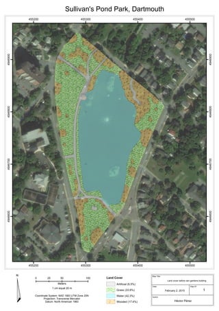
Land cover before rain gardens Sullivan's Pond Park
- 1. 455200 455200 455300 455300 455400 455400 455500 455500 4946600 4946600 4946700 4946700 4946800 4946800 4946900 4946900 Land Cover Artificial (6.5%) Grass (33.8%) Water (42.3%) Wooded (17.4%) Coordinate System: NAD 1983 UTM Zone 20N Projection: Transverse Mercator Datum: North American 1983 Sullivan's Pond Park, Dartmouth ¤ Author: Date: Map Title: Map Nº: February 2, 2015 Héctor Pérez 1 Land cover before rain gardens building 0 50 10025 Meters 1 cm equal 20 m