
Recommended
Recommended
More Related Content
What's hot
What's hot (20)
Similar to From global to local: How can spatial conservation prioritization inform conservation policies and implementation
Similar to From global to local: How can spatial conservation prioritization inform conservation policies and implementation (20)
Recently uploaded
Recently uploaded (20)
From global to local: How can spatial conservation prioritization inform conservation policies and implementation
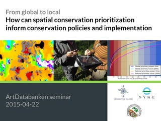
- 1. From global to local How can spatial conservation prioritization inform conservation policies and implementation ArtDatabanken seminar 2015-04-22
- 2. Hi! Joona Lehtomäki University of Helsinki Metapopulation Research Centre Conservation Biology Informatics Group @jlehtoma jlehtoma
- 3. 1 Global Local2 3 Informing policies and implementation
- 4. Background Spatial conservation prioritization • Identify spatial allocation of conservation resources (actions) • Protection • Management • Restoration • Offsetting … and various other forms of land use.
- 5. Global 1
- 6. Atte Tuuli Enrico Johanna Fede Aija Peter The team Peter
- 7. Land use change: One of the main drivers of biodiversity crisis e.g. Schipper et al. 2008, Butchart et al. 2010, Hoffmann et al. 2010, Gibson et al. 2011, Laurance et al. 2012
- 8. Protected areas: One of the main tools for fighting biodiversity loss e.g. Rodrigues et al. 2004, Butchart et al. 2012, Thomas et al. 2012, LeSaout et al. 2013
- 9. By 2020, at least 17 per cent of terrestrial and inland water, and 10 per cent of coastal and marine areas, especially areas of particular importance for biodiversity and ecosystem services, are conserved through effectively and equitably managed, ecologically representative and well connected systems of protected areas and other effective area-based conservation measures, and integrated into the wider landscapes and seascapes. CBD Aichi Target 11
- 10. 1. What is the potential performance of PA network (species ranges and ecoregions)? 2. How will land-use change by 2040 impact this performance and the spatial pattern of priorities? 3. What is the difference between globally coordinated and nationally devolved PAs? Extending the global PA network Objectives
- 11. Pouzols et al. 2014
- 12. ~25 000 Red-listed species 827 ecoregions Land use - present - future (2040) Country borders Current PAs Extending the global PA network The approach
- 13. Extending the global PA network Global land use change scenarios
- 14. In collaboration with: Extending the global PA network Global land use change scenariosvanAsselen&Verburg2012
- 15. ~25 000 Red-listed species 827 ecoregions Land use - present - future (2040) Country borders Current PAs Extending the global PA network The approach
- 18. Input features GIS Expert evaluation Ecology Feature grids Weights Costs Connectivity Areas with highest / lowest conservation value Identify expansion / restoration potential Data acquisition Data preparation Data analysis Inference Extending the global PA network Zonation workflow
- 19. Extending the global PA network The approach ~25 000 Red-listed species 827 ecoregions Land use - present - future (2040) Country borders Current PAs
- 20. Extending the global PA network Priorities 2040
- 21. Extending the global PA network National priorities
- 22. Extending the global PA network Performance curves Pouzols et al. 2014
- 23. Global loss Extending the global PA network Performance curves Pouzols et al. 2014
- 24. 19 % Extending the global PA network Performance curves Pouzols et al. 2014
- 25. 61 % Extending the global PA network Performance curves Pouzols et al. 2014
- 26. 56 % 12 % Extending the global PA network Performance curves Pouzols et al. 2014
- 27. Extending the global PA network National or international? Pouzols et al. 2014
- 28. Extending the global PA network Performance curves Pouzols et al. 2014
- 29. 43 / 38 % Extending the global PA network Performance curves Pouzols et al. 2014
- 30. • The 17 % expansion target has great potential • Land use change may change conservation needs • International collaboration is vital • Additional conservation actions needed • http://avaa.tdata.fi/web/cbig/gpan Extending the global PA network Wrap-up
- 31. Maxwell et al. (2015) Kotiahoetal.(2015) Extending the global PA network The role of international targets?
- 32. Local 1
- 33. Private Reserves State Forestry Private State Lehtomäki et al. submitted Extending the local PA network Objectives
- 34. Directed marketingAssessing sites Collaboration network Authorities Extending the local PA network Zonation as decision support tool
- 38. © Metla Woodland key habitats Protected areas © Metsähallitus
- 39. Kainuu Pohjois-Pohjanmaa Etelä-Savo Keski-Suomi Pohjois-Savo Pirkanmaa Lapin METSO-alue Pohjois-Karjala Etelä- jaKeski-Pohjanmaaja Ra Lounais-Suomi ja Rannikko Häme-Uusimaa jaRannikko Kaakkois-Suomi
- 43. Computationally easier Higher ecological realism, more useful planning Arponenetal.2012 Extending the local PA network Scale matters
- 46. • Great emphasis on the validity of the results • Analysis resolution needs to be matched with the planning need • Stakeholder involvement important • Multiple conservation actions needed Extending the local PA network Wrap-up
- 48. Informing policies and implementation Alternative/complementary models Dicks et al. 2014
- 49. Data Scientists Policymakers Stakeholders and the public Knowledge Decisions Informing policies and implementation The deficit-linear model of science-policy interaction Soranno et al. 2014; Young et al. 2014
- 50. • Data • Knowledge • Decisions Informing policies and implementation The roundtable model of science-policy interaction Soranno et al. 2014; Lynman et al. 2007
- 51. Credibility The scientific adequacy of the technical evidence and arguments. Salience (relevance) The relevance of the assessment to the needs of decision makers. Legitimacy The perception that the production of information and technology has been respectful of stakeholders’ divergent values and beliefs, unbiased in its conduct, and fair in its treatment of opposing views and interests. Cash et al. 2003 Informing policies and implementation Attributes of science-policy interface
- 52. Credibility Increased by bringing multiple types of expertise to the table. Salience Increased by engaging end-users early in defining data needs. Legitimacy Increased by providing multiple stakeholders with more, and more transparent, access to the information production process. Cash et al. 2003 Informing policies and implementation Attributes of science-policy interface
- 53. Credibility Quality assessment Communication of uncertainties Supply-driven Salience Timely Simple Demand-driven Legitimacy Consensus Wide participation Range of views Sarkki et al. 2013 Informing policies and implementation Trade-offs Possible in global context?
- 54. • Global prioritization can produce informative results, but who exactly are we informing? • Local prioritization usually has well-defined scope, but is it too parochial? • In both cases, need for better data • Scope for work at scales between global and local? Informing policies and implementation Conclusions
- 55. Fennoscandian green-belt © CBD Informing policies and implementation Conclusions
- 56. Collaborators Funders MINISTRY OF AGRICULTURE AND FORESTRY
- 57. Thanks for listening! Joona Lehtomäki joona.lehtomaki@helsinki.fi twitter: @jlehtoma
- 58. References Cash, D.W. et al. (2003) Knowledge systems for sustainable development. Proceedings of the National Academy of Sciences of the United States of America 100, 8086–91 Dicks, L. V et al. (2014) Organising evidence for environmental management decisions: a “4S” hierarchy. Trends in Ecology & Evolution 29, 607–613 Lehtomäki, J. (2014) , Spatial conservation prioritization for Finnish forest conservation management. , University of Helsinki Lehtomäki, J. et al. (2009) Applying spatial conservation prioritization software and high-resolution GIS data to a national-scale study in forest conservation. Forest Ecology and Management 258, 2439–2449 Lynam, T. et al. (2007) A Review of Tools for Incorporating Community Knowledge , Preferences , and Values into Decision Making in Natural Resources Management. Ecology And Society 12, 5 Sarkki, S. et al. (2013) Balancing credibility, relevance and legitimacy: A critical assessment of trade-offs in science-policy interfaces. Science and Public Policy Soranno, P.A. et al. (2015) It’s good to share: Why environmental scientists' ethics are out of date. BioScience 65, 69–73 Pielke Jr, R.A. (2007) The Honest Broker: Making Sense of Science in Policy and Politics, Cambridge University Press. Young, J.C. et al. (2014) Improving the science-policy dialogue to meet the challenges of biodiversity conservation: Having conversations rather than talking at one-another. Biodiversity and Conservation 23, 387–404
- 59. References – conservation biology Cook, C.N. et al. (2013) Achieving conservation science that bridges the knowledge-action boundary. Conservation Biology 27, 669–678 Opdam, P. (2010) Learning science from practice. Landscape Ecology 25, 821–823 Reyers, B. et al. (2010) Conservation Planning as a Transdisciplinary Process. Conservation biology 24, 957–65
Editor's Notes
- Misleading picture, I work with computers most of the time.
- - Fontit
- Paikallisen tason suunnittelun tarkoitus siis tuottaa käyttökelpoisia työkaluja viranomaisten käyttöön. Koska METSO perustuu vapaaehtoisuuteen, voidaan suojeluprioriteetteja käyttää eri kohteiden vertailussa (luonnontieteelliset valintakriteerit edelleen perustana) tai maanomistajien aktivoinnissa (jos löytyy mielenkiintoisen oloisia kohteita) Suunnittelutyön tuloksista voidaan tiedottaa esimerkiksi alueellisen yhteistoimintaverkoston kautta. tuskeino Tarkoituksenmukainen rajaus Hoitotyöt Hoito-ohje metsänomistajalle
- Several potentially useful data sources primarily collected for forestry can be used for conservation prioritization as well Again, primary biodiversity data would be desirable, but often these data are not available for large areas. Detailed forest planning data mostly on stand level is available for most of Finland (and Sweden?). These are further complemented by national forest inventory data based on remote sensing. Then the questions becomes how to derive biodiversity-relevant information from these data? Several options exist: Simple habitat-suitability indexes More complex and realistic statistical models for various species or communities Mechanistic/process models for whole communities Operational use of the whole toolset should not be dependent on the particular tool used (although details will vary).
- Spatial conservation prioritization analysis described only provide decision-support: The most important decision criteria should, of course, still be what is actually there (field inventories). By closely linking the result interpretation and field inventories, should work as validation and development benchmark for the methods used. This (validation) nothing new for any predictive analytical methods, but for operational conservation planning it is a crucial component of the whole workflow. Special care needs to be directed to opening up the decisions, methods and results for practitioners who may not have a scientific background.
- “Many initiatives exist to improve communication, but these largely conform to a ‘linear’ or technocratic model of communication in which scientific ‘‘facts’’ are transmitted directly to policy advisers to ‘‘solve problems’’. While this model can help start a dialogue, it is, on its own, insufficient, as decision taking is complex, iterative and often selective in the information used.” - Young et al. 2014
- Three attributes of science-policy interface
- Shold stakeholders be involved in science, or does it pollute science?