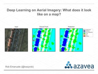
Deep Learning on Aerial Imagery: What does it look like on a map?
•Download as PPTX, PDF•
1 like•1,052 views

A presentation from CalGIS/LocationCon 2017 that was pretty demo heavy.

Recommended
Recommended
More Related Content
What's hot
What's hot (20)
Similar to Deep Learning on Aerial Imagery: What does it look like on a map?
Similar to Deep Learning on Aerial Imagery: What does it look like on a map? (20)
Recently uploaded
Recently uploaded (20)
Deep Learning on Aerial Imagery: What does it look like on a map?
- 1. Deep Learning on Aerial Imagery: What does it look like on a map? Rob Emanuele (@lossyrob)
- 2. What we’ll cover • Describe the ISPRS Potsdam image segmentation contest • Brief overview of some Deep Learning concepts • View and analyze results of model predictions on a map
- 6. GeoTrellis • a Scala library for geospatial data types and operations. • enables Spark to work with geospatial data for raster processing at scale • provides lots of raster processing capability for web servers and distributed computation
- 10. σ x 1 x 3 y Inputs (xi) are weighted by the wis The neuron “fires” if the summed activation (x·w) is above a threshold, giving y [In reality, y = σ(x·w), where σ is some “thresholding” function] w1 w2 w3 x 2 Artificial Neurons
- 11. https://commons.wikimedia.org/wiki/File:Artificial_neural_network.svg Artificial Neural Network (ANN)
- 12. Deep Neural Network (DNN) …
- 13. Deep Neural Network (DNN) … THE DEEP PART
- 14. Convolutional Neural Network (CNN) https://commons.wikimedia.org/wiki/File:Typical_cnn.png
- 15. Fully Convolutional Network (FCN)
- 16. Source: https://lmb.informatik.uni-freiburg.de/Publications/2015/RFB15a/ U-Net: Convolutional Networks for Biomedical Image Segmentation
- 23. EXPERIMENT 2: FCN w/ IRRG
- 25. EXPERIMENT 3: CROSS VALIDATION LATE FUSION ENSEMBLE
- 32. LET’S EXPLORE THE MAP
- 33. FUTURE WORK
- 34. Future Raster Vision Work • Other CV tasks: Image Recognition, Object Detection • Infrastructure/Workflow improvements: utilize AWS Batch for distributed training over hyperparameters • Integration into • Inference on the fly, on the map or through an API
- 35. THANK YOU Rob Emanuele (@lossyrob)