
Recommandé
Contenu connexe
En vedette
En vedette (20)
Similaire à Upper Truckee River
Similaire à Upper Truckee River (20)
Dernier
Dernier (20)
Upper Truckee River
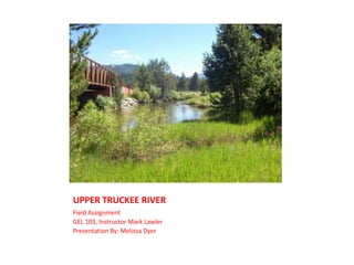
- 1. UPPER TRUCKEE RIVER Field Assignment GEL 103, Instructor Mark Lawler Presentation By: Melissa Dyer
- 2. UPPER TRUCKEE RIVER I live directly across the street from the Upper Truckee River. I simply walked across the street and found a treasure trove of geological evidence. Here is what I observed.
- 3. UPPER TRUCKEE RIVER The push pin represents where I did my field trip. Hwy 50 is the road running vertical.
- 4. HISTORY The main rocks identified within the area are granitic rocks and glacial deposits. Other rocks, that are much less extensive are pluvial and alluvial deposits, volcanic rock, and metamorphic rock. The geology of the area can be characterized by lake and glacial deposits at lower altitudes, flatlands, and low-lying hills. Also, by granitic rocks that make up the steep and high mountain slopes and peaks. The only volcanic rocks within the area are in the extreme headwaters of the Upper Truckee River. The only metamorphic rocks are two small areas above Echo Lake and two small areas in the low-lying hill between the City of South Lake Tahoe and Fallen Leaf Lake. Lake deposits are evident in a few high-mountain meadows and along the lower stream channels in the Upper Truckee River and Trout Creek. Landforms of the area were primarily shaped from tectonic and glacial processes. A combination of basin-and-range style fault-bounded blocks, as well as glacial erosion and deposition, resulted in the formation of the present-day landforms. Four periods of major glaciation shaped these landforms. The major landforms attributed to glaciation are deep basin-fill deposits, steep mountain slopes adjacent to the topmost reaches of the Upper Truckee River and Trout Creek, and large lateral moraines that divide the Trout Creek from the Upper Truckee River and the Upper Truckee River from Fallen Leaf Lake. The basin-fill deposits within the area are comprised entirely of lake, stream, and glacial deposits. Also, the underlying basement rock is assumed to be entirely granitic. Thicknesses of the basin-fill deposits in the South Lake Tahoe area near Lake Tahoe may be as great as 1,600 - 1,900 ft (Blum, 1979.
- 5. Rocks These igneous and sedimentary rocks are laying all together near the shoreline of the Truckee River.
- 7. It is grey with bands of lighter and darker grey as well as bands of red-orange.
- 8. The layers can be felt as ridges.
- 10. This sample is an intrusive igneous rock.
- 11. It is rounded from tumbling in the river.
- 12. The rock has traces of quartz and is speckled black with some pink and grey speckles.
- 13. I believe that the rock is Diorite.
- 15. It is dark green with black crack lines all the way through.
- 18. Is prevalent all over Lake Tahoe.
- 19. Classification:
- 20. Lupinus grayi (S. Watson) S. Watson
- 22. Sub kingdom Tracheobionta – Vascular plants
- 23. Super division Spermatophyta – Seed plants
- 24. Division Magnoliophyta – Flowering plants
- 25. Class Magnoliopsida – Dicotyledons
- 26. Subclass Rosidae
- 27. Order Fabales
- 29. Family Genus Lupinus L. – lupine
- 31. Cliff Swallows (Cont.’d) Small, long-winged stocky songbird. Small bill. Wings are long and pointed. (“dart”-like) They have a dark throat. Their tail is square. Their backside is pale. The nest is a covered bowl made of mud pellets, with a small entrance tunnel on one side. Typically lined with grass. Nests are placed on a vertical wall, usually just under an overhang. These birds form colonies. They are insectivorous and an important part of the summer ecology in Lake Tahoe. Unknown as to when they first presented in Lake Tahoe, but they are a common perch-bird across the country.
- 32. Resources Cornell Lab of Ornithology USDA Natural Resources Conservation Service USGS (Tahoe Regional Planning Agency and U.S. Forest Service, 1971, plate) Geology.com Google Earth All photos are mine with the exception of the Cliff Swallow and Cliff Swallow Range Map
Notes de l'éditeur
- Source: Google Earth
- Source: USGS(Tahoe Regional Planning Agency and U.S. Forest Service, 1971, plate)
- Source: geology.com
- Source: geology.com
- Source: geology.com
- Source: USDA Natural Resources Conservation Service (plants.usda.gov)
- Source: Cornell Lab of Ornithology
- Source: Cornell Lab of Ornithology