
Recommandé
Contenu connexe
Tendances
Tendances (19)
En vedette
En vedette (20)
Similaire à Physical Landscapes
Similaire à Physical Landscapes (20)
Plus de neilgood
Plus de neilgood (16)
Dernier
Dernier (20)
Physical Landscapes
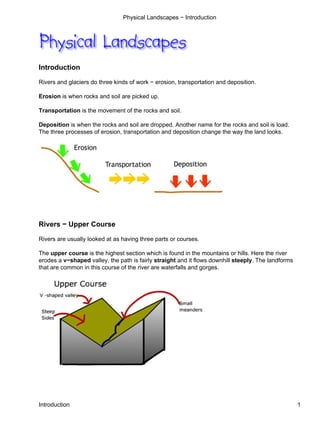
- 1. Physical Landscapes − Introduction Introduction Rivers and glaciers do three kinds of work − erosion, transportation and deposition. Erosion is when rocks and soil are picked up. Transportation is the movement of the rocks and soil. Deposition is when the rocks and soil are dropped. Another name for the rocks and soil is load. The three processes of erosion, transportation and deposition change the way the land looks. Rivers − Upper Course Rivers are usually looked at as having three parts or courses. The upper course is the highest section which is found in the mountains or hills. Here the river erodes a v−shaped valley, the path is fairly straight and it flows downhill steeply. The landforms that are common in this course of the river are waterfalls and gorges. Introduction 1
- 2. Physical Landscapes − Introduction Rivers − Middle Course In the middle course the angle that the river flows down is less steep, the river begins to meander and the valley sides are also less steep. Common landforms here are river beaches and river cliffs. Rivers − Lower Course The lower course has the gentlest slopes − both in long profile and across the valley floor. This almost flat land is known as the flood plain. The river may have very large meanders and ox−bow lakes. The mouth of a river is when it reaches open water − either a lake or the sea. Under certain conditions a delta can be found here. Upper Course Landforms Waterfalls are most common in the upper course. They are formed when a river crosses a layer of harder rock. This layer is eroded more slowly than the softer rock beneath it. Eventually a step in the profile of the river is formed with a plunge pool formed in the softer rock. As the layer of hard rock is undermined it will collapse and so the waterfall moves upstream. This forms a narrow valley with steep sides − a gorge. Rivers − Middle Course 2
- 3. Physical Landscapes − Introduction Middle Course Landforms Features found in the middle course are river cliffs and river beaches. A river cliff is found on the outside of a meander. Here the water is flowing quickly into the bank. The powerful current is able to erode the side of the river and it makes a steep bank, or river cliff. Middle Course Landforms 3
- 4. Physical Landscapes − Introduction On the inside of the bend the water is flowing much more slowly. It has less power to transport its load and often deposition will take place. The shallow water and gentle slope on the inside of a bend is a river beach. Lower Course Landforms The lower course has the widest rivers and the largest meanders. The river is most likely to flood in this section and when it does a short cut can be formed. The river will flow through the shorter route, leaving the curve of the meander cut off. This is known as an ox−bow lake. 1. The river is starting to meander. Erosion is greater on the outside of the bend, deposition more on the inside. 2. Large meanders have formed 3. The river cuts through the meander, leaving a straighter section and an ox−bow lake. Land Use − Upper Course In the upper course of a river valley the land is highest, steepest and most exposed. The weather in this part of the valley is colder, wetter, windier and more humid than the parts lower down. Snow lies here for longer than elsewhere. The soils are often acid, thin and waterlogged. All these limitations make it difficult to make use of the land in the upper course. Lower Course Landforms 4
- 5. Physical Landscapes − Introduction Farming is extensive, with forestry, hill sheep and deer stalking being common uses. Buildings and transport links are rare. This lack of development makes the land attractive for hill walkers and rock climbers, and some areas in the highest part can be used for winter sports like skiing and snowboarding. The heavy rain does make the land suitable for reservoirs and the fast flowing rivers can be damned to make hydroelectric power stations. Land Use − Middle Course The land is getting lower, less steep and the climate is less extreme. This allows for greater use of the valley. Arable farming can now take place although livestock will still be found. The land is suitable for building and there are villages and small towns here. The flatter and wider valley floor may have road and even rail transport links. Forestry is still carried out in the middle course, especially where the soil is not fertile enough for farming. The wider range of activities available to people here means that the population density is greater than in the upper course. Land Use − Lower Course Here the land is low, flat or very gently sloping, and the temperatures are warmest. The soils are often deep and fertile and so the land is best suited to intensive agriculture with arable farms and market gardens. Close to the river the land may be marshy or at risk from flooding and is therefore kept as permanent pasture for livestock. The largest settlements and greatest concentration of road and rail links are found in the lower course. The largest industrial areas, which need good communications, many workers and large areas of flat land are also located here. This part of a river valley has the greatest population density. Land Use − Middle Course 5
- 6. Physical Landscapes − Introduction Landscapes made by glacial erosion Land in the hills and mountains is colder and recieves more precipitation. Snow will fall in these upland areas, and if the temperature is cold enough can remain through the summer. The next winter's snowfall piles up on top squeezing the lower layers that eventually turn into ice. The ice, due to the pull of gravity, begins to slide downhill and erodes the rock it passes over. It erodes in two ways − by plucking and by abrasion. Plucking is the ice freezing on to a jagged piece of rock and pulling it out as the ice continues to move downhill. It is similar to a dentist pulling out teeth. Abrasion happens when ice already has fragments of rock embedded in its base and these scrape at the rock surface. This process can be compared to sandpaper smoothing wood. U−Shaped Valleys A U−shaped valley is the shape left after a valley has been overdeepened by a glacier. The original V−shaped valley, which would have been made by a river, is widened and deepened after the ice has eroded the sides and bottom of the valley. V−shaped valleys have a wide flat floor, which may contain ribbon lakes (long and narrow) and mis−fit streams (so called because they are too small to have made the valley). The sides of U−shaped valleys may have hanging valleys, which are side valleys that are left high on the side of a main valley that has been deepened by glaciation. Streams flowing in a hanging valley may form a waterfall as it flows down the steepened sides. The valley sides may also have truncated spurs which are the ends of sloping ridges cut off (or truncated) by the valley glacier which tends to flow straighter than a river. Landscapes made by glacial erosion 6
- 7. Physical Landscapes − Introduction Corries Corries are armchair−shaped hollows, which are found high up on the sides of hills. They are often formed on the shaded and therefore colder side of the hill. Here the snow does not melt as fast and there can be a build up of snow which is squashed and turned into ice. As the ice moves downhill it erodes the underlying rock, eventually producing a corrie. Often two or more corries are formed leaving a narrow ridge between them. This is called an arete. When a hill has been heavily eroded with 3 or 4 corries the jagged hill that is left is known as a horn or pyramidal peak. Corries 7
- 8. Physical Landscapes − Introduction The diagrams below show the side−on view of a corrie during and after glaciation. The diagram above shows a simplified version of what a corrie looks like on an OS map. Land use in Glaciated Uplands Upland areas that have been glacially eroded are used in a variety of ways, but they also limit what human activities can take place. The stark rugged scenery of mountains in areas of low population density and therefore low pollution attract people who want to get away from it all by angling, walking and rock climbing. Land use in Glaciated Uplands 8
- 9. Physical Landscapes − Introduction The majority of visiters are more passive than active, that is they will visit by car or bus and view the scenery from the road. Where snowfall is predictable skiing and snowboarding facilities have been developed, although this is not a quiet, peaceful activity. In the Scottish Highlands deer stalking and grouse shooting are important activities as they provide jobs and bring in money to remote communities. Fish farming in coastal areas has grown enormously as source of income, whilst salmon fishing is not as important now due to the recent decline in the wild salmon numbers. Heavy precipitation amounts have encouraged the building of hydroelectric power (HEP) dams, where water flow is used to turn turbines and generate electricity. Commercial forestry and quarrying are other economic activities in this type of area. This map shows what corries, aretes and a pyramidal peak would look like on an OS map. Problems in Glaciated Uplands This type of scenery has limitations caused by the high altitude, steep slopes, thin and infertile soils, heavy rainfall and low temperatures. This prevents any kind of intensive agriculture with hill sheep farming being the most important. Communications are difficult and roads and railways are usually only found in the valley floors. The remoteness is a disadvantage as it costs more to import and export goods, and the cost of living for the inhabitants is consequently higher. The unspoilt nature of the glacial highlands has meant that land use conflicts occur. Often the need to develop an area by, for example, opening up a quarry or enlarging a ski resort will conflict with the desire to protect the environment. Problems in Glaciated Uplands 9
- 10. Physical Landscapes − Introduction Landscapes made by Glacial Deposition Deposition from ice happens mostly when the temperature is high enough. The lowlands at the edge of ice sheets and glaciers have deposits that have been made by melted ice (fluvioglacial). Glacial deposits are those dropped directly underneath the ice. The table below shows many of the features of a landscape made by melting ice. Feature How it was formed Appearance Makes the ice look Moraine Rock carried by the glacier discoloured A low curved ridge. Lies Material bulldozed by a glacier and left at the Terminal Moraine across a valley when end of the ice sheet or glacier made by a glacier A unsorted deposit, that The moraine from the ice is dropped directly is a jumble of rock Till (boulder clay) down fragments of different sizes mixed together Moraine−dammed Water melting from ice is trapped behind a Often long and narrow Lakes terminal moraine Flat area with sorted deposits, that is Outwash Plain Melt water streams dropped layers of deposits separated into layers with similar sized fragments Low, winding gravel Melt water streams flowing through the ice ridges, roughly parallel Eskers become choked with deposits. The deposits to the direction of ice are left after the ice has melted flow Fine grains of moraine which has been Flat or gently undulating Loess transported and deposited by wind lowlands Low hills in the shape of Drumlin Moving ice moulds the moraine underneath it half an egg Feature How it was formed Appearance Landscapes made by Glacial Deposition 10
- 11. Physical Landscapes − Introduction Human Activity and Glacial Deposition People have been able to use these landscapes to their advantage. Some deposits e.g. till can be fertile and well drained. East Anglia in England has productive arable farmland as a result of the underlying glacial deposits. Loess deposits are particularly fertile. As outwash plains are made up of sorted materials where the deposits have already been graded into different sized fragments many quarries exploit these materials. As in the uplands lakes produced by ice in the lowlands are used for recreation and water supply. However, these landscapes can also cause problems. Many soils made by glacial deposition are not fertile and can be poorly drained making marshland. The lakes in lowland areas can make transport more difficult. Human Activity and Glacial Deposition 11