NJ Future Forum 2012 Complete Streets Kremer

The New Jersey Department of Transportation instituted a “Complete Streets” policy in 2009, joining a handful of other states that have adopted policies to plan, design and build state roads that are accessible to all users, not just cars. More than a dozen New Jersey local governments have followed suit, implementing policies that apply to local roads and streets. The city of Hoboken has been an early leader, becoming one of the first municipalities on the East Coast with a public bike repair facility and has doubled the number of bike racks near transit and striped its first “buffered” bike lane. Jersey City also has a Complete Streets policy and the city’s Route 440 boulevard project may serve as a valuable case study in renovating state highway corridors. Complete Streets policies have multiple benefits and have recently been identified as an obesity prevention tool by Shaping New Jersey and the New Jersey Partnership for Healthy Kids.

Recommended
Recommended
More Related Content
What's hot
What's hot (20)
Viewers also liked
Viewers also liked (20)
Similar to NJ Future Forum 2012 Complete Streets Kremer
Similar to NJ Future Forum 2012 Complete Streets Kremer (20)
More from New Jersey Future
More from New Jersey Future (20)
Recently uploaded
Recently uploaded (10)
NJ Future Forum 2012 Complete Streets Kremer
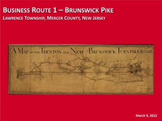
- 1. BUSINESS ROUTE 1 – BRUNSWICK PIKE LAWRENCE TOWNSHIP, MERCER COUNTY, NEW JERSEY March 9, 2012
- 2. AGENDA • Location • Study Corridor • Vision • Timeline of accomplishments to date • Findings • Current status and next steps • Lessons learned
- 3. LOCATION • Lawrence Township, Mercer County • Typical of Central New Jersey Suburban • Focus area is one of three “downtowns”
- 4. REGIONAL CONTEXT • Regional context.pdf
- 6. BRUNSWICK TURNPIKE • Transportation issues – Excessive travel speeds – Limited pedestrian accommodations – Arterial highway design divides community • Land use issues – Many parcels pre-date zoning – Small, undersized lots – Some industrial sites close to Route 1 Freeway and D&R Canal – Some new development and redevelopment – Stable residential neighborhoods – Walkable elementary school … for some
- 12. CORRIDOR VISION • Leverage redevelopment potential • Propose mixed use • Walkable design to promote pedestrian activity • Emphasize Gateway elements • Slow traffic speeds • Create a “Complete Street” linked to compatible land use elements
- 13. TIMELINE • 1994 – Growth management concept initiated • 1995 – Master Plan update • 1996 – Colonial Heights Civic Assoc. Vision • 1998 – Brunswick Pike Boulevard Study/ KMM TMA • 1998 – Redevelopment Area Report/Schoor DePalma • 1999 – Twp Council resolution designating redevelopment area • 2000 – Township traffic study • 2001 – Community forum/public meeting • 2002 – Student redevelopment visioning study • 2002 – Existing Conditions Study/NJDOT/Vollmer • 2000s – Various properties purchased and assembled • 2003,7 – Brunswick Pike South Vision Plan/Clarke Caton Hintz • 2010 – Concept Development Report/Stantec • 2011 – TCDI grant Redevelopment Plan & Form-based Zoning/CCH • 2011 – Final design contract initiated/Parsons Brinkerhoff • 2014 – TIP estimated start of construction
- 14. FINDINGS • Mismatch between roadway design and function • Traffic data consistently supports need for 4 lanes • Design to link of land use and transportation elements – Boulevard concept and redevelopment options • Design considerations – Left turns and medians – On-street parking – Traffic calming – Pedestrian accommodations – Must support redevelopment • Aesthetics critical concern for Township
- 15. CURRENT STATUS • Final ROW Plans – July 2012 • Final Design Plans – January 2013 • Advertise – December 2013 • Construction – March 2014 to February 2015
- 16. LESSONS LEARNED • Consistent community support and vision • Need to link land use and transportation • Flexibility • Some design details and design exceptions still under consideration
- 19. FORM-BASED ZONING CODES • DVRPC grant • Redevelopment Plan • Predictability for Township and Developers • Emphasizes aesthetics and physical design as the organizing principal of redevelopment plan
- 20. Peter F. Kremer Supervising Transportation Planner Parsons Brinkerhoff, Inc. 609-512-3539 kremer@pbworld.com
Editor's Notes
- Map is over 200 years oldAnd you can see just how straight Route 1 is and always been, especially when compared the parallel Routes 206 and 27, which certainly appear to follow the topography much more closely.
- Today we’ll be talking about The study area and corridorLand use and transportation issuesLook at timeline of the various studies and reportsCurrent statusLessons learned
- Lawrence Township is located between Trenton and Princeton in Mercer CountyVery much a typical suburban community in Central New JerseyPopulation density is about 1,500/ sq mile, so slightly ahead of the statewide averageLand uses in Lawrence Township include everything from highway commercial and offices to preserved farmlandThe focus area is one of three downtowns in Lawrence TownshipTwo are located un U.S. Route 206This location is on Business Route 1, just north of the Brunswick Circle and Trenton
- He’s a view of the region and you can see Route 1 running diagonally through the center of the mapPoint out freeway section and Business Route 1 section
- Zooming in to the local context, you can see just how much the transportation elements framethe corridor
- The Brunswick Turnpike is an historic corridor in central New JerseyOriginally chartered as a part of the Trenton and New Brunswick Turnpike Road in 1803Designated as State Route 26 in 1927Brunswick circle was built in 1930This segment became Business Route 1 when the parallel Trenton Freeway was completed The completion of the parallel freeway rendered the arterial design of the roadway obsolete, but the design and cross section have remained the essentially the same. So while the roadway looks and functions like an arterial, its purpose is now to serve a mix of both local and through traffic The land use and transportation elements of Business Route 1 are incompatibleThe result is what you’d expect review transportation and land use issues.
- Here we can see the residential zones and the potential for a walkable community. The central corridor is surrounded by residential neighborhoodsBut the principal transportation features:Business Route 1The Brunswick Circle, and Whitehead Road.. all divide the community, instead of bringing it together. The star pinpoints the location of the Slackwood Elementary Scholl, but you can see that its really is walkable only if you live on that side of the roadway.
- But if you look beyond that issue, the bulk of the residential zones are within a ¼ mile walking distance of Brunswick Pike so the potential certainly does exist to create a walkable community
- And if we look further at the zoning, again we can see significant concentrations of walkable residential development along with Neighborhood Center Zoning – not Highway Commercial zoning - directly along the Brunswick Pike. This is an important distinction because the Neighborhood Center is much more compatible with the concepts of a walkable community
- But if you look at the actual uses that are currently in place, many including warehousing, utilities, and some of the highway commercial-type uses are certainly more auto-oriented than they are pedestrian-oriented and in several cases, do not lend themselves to a location that should be the southern gateway into town.Still have some Vacant parcels that provide significant opportunities to implement the vision
- So given that context, let’s take another look at one of the previous slides…… The idea of a Northern Gateway should be an integral part of the both roadway and land use elementsBut to make that a reality requires both TRANSPORTATION and LAND USE changes to come together in ways that reinforce the ideas of access, walkability, traffic calming, and aesthetics
- Mention recent GaryToth piece that linked complete streets concept with the need to match roadway design with the current or desired land use context
- The timeline that I pieced together shows that this is not an isolated concept. Rather there has been consistent and on-going effort bringing together community groups and business owners, the Township, and the Department of Transportation. And its has included everything from public meetings, to visioning, to traffic studies, and now Roadway Design and Form-Based Zoning Codes.All of this leading to – by 2014 – the start of construction.
- Current design – a Principal Arterial Highway - dates back to at least 1959 – does not match the goal and vision of a walkable community. The road has to look and function in a very specific way to attract the appropriate type of private investment, development, and redevelopment
- Design and Construction limited to curb-to-curb, so no significant streetscape improvementsAny changes to Brunswick Circle not likely
- The biggest design challenge is to replace the existing signalized intersection at Whitehead Road with a Modern RoundaboutThe Roundabout design …creates a northern Gatewayslows traffic and defines the signature aesthetic look of the corridor