Magnitude 6.5 OFFSHORE NORTHERN CALIFORNIA
•Télécharger en tant que PPT, PDF•
1 j'aime•303 vues


Recommandé
Contenu connexe
Tendances
Tendances (18)
En vedette
En vedette (11)
Similaire à Magnitude 6.5 OFFSHORE NORTHERN CALIFORNIA
Similaire à Magnitude 6.5 OFFSHORE NORTHERN CALIFORNIA (20)
Plus de Ali Osman Öncel
Plus de Ali Osman Öncel (20)
Dernier
Dernier (20)
Magnitude 6.5 OFFSHORE NORTHERN CALIFORNIA
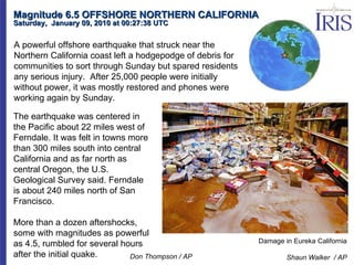
- 1. Magnitude 6.5 OFFSHORE NORTHERN CALIFORNIA Saturday, January 09, 2010 at 00:27:38 UTC Damage in Eureka California Shaun Walker / AP The earthquake was centered in the Pacific about 22 miles west of Ferndale. It was felt in towns more than 300 miles south into central California and as far north as central Oregon, the U.S. Geological Survey said. Ferndale is about 240 miles north of San Francisco. More than a dozen aftershocks, some with magnitudes as powerful as 4.5, rumbled for several hours after the initial quake. A powerful offshore earthquake that struck near the Northern California coast left a hodgepodge of debris for communities to sort through Sunday but spared residents any serious injury. After 25,000 people were initially without power, it was mostly restored and phones were working again by Sunday. Don Thompson / AP
- 2. Magnitude 6.5 OFFSHORE NORTHERN CALIFORNIA Saturday, January 09, 2010 at 00:27:38 UTC graphic from productivedreams.com "broken glass, bookcases over, no power. Folks checking on neighbors..." "Some power lines down, large boulders in the road, and city hall damaged in Ferndale, but no major damage reported." "whoa! we shook!!! no power, but we're alive and our house is still standing." "live feed from Humboldt County says residents are being evacuated due to gas leaks." "Falling caribou head narrowly missed striking employee"
- 3. Magnitude 6.5 OFFSHORE NORTHERN CALIFORNIA Saturday, January 09, 2010 at 00:27:38 UTC After the Earthquake-- Interior of Eureka Books Before the Earthquake-- Eureka Books Interior Used, Rare and Collectable Books Saxon Holt Before and After Photographs
- 4. Magnitude 6.5 OFFSHORE NORTHERN CALIFORNIA Saturday, January 09, 2010 at 00:27:38 UTC Eureka Natural Foods Shaun Walker / Eureka Times-Standard / AP Eureka Natural Foods employees clean up the store's wine section as a back-up generator provides power after the earthquake Saturday. Shaun Walker / Eureka Times-Standard / AP Earthquake Damage
- 5. USGS This earthquake (star), plotted here with regional historical seismicity, occurred in a deformation zone of the southernmost Juan de Fuca plate (off the coast of Northern California) that is commonly referred to as the Gorda plate. The earthquake’s epicenter is northwest of the Mendocino Triple Junction, which is formed by the intersection of the Mendocino fracture zone, the San Andreas fault and the Cascadia subduction zone. It is one of the most seismically active parts of the San Andreas fault system that runs through California state. Magnitude 6.5 OFFSHORE NORTHERN CALIFORNIA Saturday, January 09, 2010 at 00:27:38 UTC Earthquake and Historical Seismicity
- 6. USGS Magnitude 6.5 OFFSHORE NORTHERN CALIFORNIA Saturday, January 09, 2010 at 00:27:38 UTC The Gorda plate (southernmost Juan de Fuca Plate) is subducting beneath the North America plate at about 2.5-3 cm/year in the direction N50E. The Gorda plate is also subjected to intense compressive stresses by oblique-convergence of the northwestward migrating Pacific Plate as well as localized eastward spreading at the Gorda Ridge. The resulting internal deformation of the Gorda plate is manifested primarily by intraplate strike-slip events on vertical NE-oriented faults. From Parks and Plates by Bob Lillie Regional Tectonics
- 7. The tension axis (white circle) reflects the minimum compressive stress direction. The pressure axis (gray circle) reflects the maximum compressive stress direction. Strike-Slip Faulting NCSS Moment Tensor Solution Magnitude 6.5 OFFSHORE NORTHERN CALIFORNIA Saturday, January 09, 2010 at 00:27:38 UTC Although this earthquake was near the southern part of the Cascadia subduction zone, the faulting motion during the earthquake was strike-slip (side-by-side like the San Andreas Fault) rather than thrust faulting that one would expect on a subduction zone boundary. According to the US Geological Survey: “The Gorda plate is subjected to intense compressive stresses by oblique-convergence of the northwestward migrating Pacific Plate as well as localized eastward spreading at the Gorda Ridge. The resulting internal deformation of the Gorda plate is manifested primarily by intraplate strike-slip events on vertical NE-oriented faults.”
- 8. Magnitude 6.5 OFFSHORE NORTHERN CALIFORNIA Saturday, January 09, 2010 at 00:27:38 UTC Aftershocks Like most earthquakes, the recent earthquake is expected to be followed by numerous aftershocks. Aftershocks are additional earthquakes that occur after the mainshock and in the same geographic area. The probability of a strong and possibly damaging aftershock (M>5) in the 7 days following the earthquake is approximately 78%. Most likely, the mainshock will be the largest in the sequence. However, there is a small chance (~5-10%) of an earthquake equal to or larger than this mainshock in the next 7 days. In addition, numerous M3-5 aftershocks are expected to occur in the same 7-day period, but most are unlikely to be felt due to the distance from land. Aftershock Distribution Google Earth
- 9. Magnitude 6.5 OFFSHORE NORTHERN CALIFORNIA Saturday, January 09, 2010 at 00:27:38 UTC Tsunami Risk Residents of Northern California coastal communities have reason to worry about tsunamis. In 1964, a magnitude 9.2 earthquake off the Alaskan coast sent a catastrophic tsunami to Crescent City, north of Eureka, killing 11 people. However, the NWS Pacific Tsunami Warning Center issued the following statement: BASED ON ALL AVAILABLE DATA A DESTRUCTIVE PACIFIC-WIDE TSUNAMI IS NOT EXPECTED AND THERE IS NO TSUNAMI THREAT TO HAWAII Damage from 1964 Tsunami in Crescent City NOAA This is completely expected since the horizontal displacement of this earthquake should not generate a tsunami because the ocean floor is not offset vertically during the earthquake.
- 10. Magnitude 6.5 OFFSHORE NORTHERN CALIFORNIA Saturday, January 09, 2010 at 00:27:38 UTC The record of the Northern Calfornia earthquake on the University of Portland AS-1 seismometer is illustrated below. Portland is about 573 km (356 miles, 5.16 degrees) from the location of this earthquake.
- 11. Magnitude 6.5 OFFSHORE NORTHERN CALIFORNIA Saturday, January 09, 2010 at 00:27:38 UTC The first P-wave energy arrived at UPOR as P n at 1 minute and 16 seconds (76 seconds) after the earthquake. P n is a compressional wave only seen in earthquakes that within several hundred kilometers from the recording station. While P-wave energy travels a curved path through the mantle, P n travels in the upper mantle just below the Mohorovicic discontinuity (Moho) at the base of the crust. For an earthquake within several hundred kilometers of the recording station, there is no clear separation between the arrivals of the S waves and the later-arriving surface waves that produced the largest ground oscillations. Traveling the same path as the P n wave energy, S n is the first S-wave energy that arrived 2 minutes and 16 seconds (136 seconds) after the earthquake.
- 12. Magnitude 6.5 OFFSHORE NORTHERN CALIFORNIA Saturday, January 09, 2010 at 00:27:38 UTC Seismic Waves Cross the Country Google Earth CHCA KWKS SBNY DAIL CBCA