SlideShare a Scribd company logo
1 of 1
Download to read offline
Simple, inexpensive aerial photography mapping
Project Data


   •Chapter: EWB-USA San Francisco Professionals
   •Project: Simple, Inexpensive Aerial Photography Mapping with Balloons,
   Kites or R/C aircraft
   •Location: Various                                                                                                         In April 2010, Deepwater Horizon rig
   •Project phase: Demonstrated technology, available for chapters to use in                                                  exploded and sank in the Gulf of                 Port Sulphur Wilkinson Bay imaging                Stitch of the oil spill at Chandeleur
   their projects                                                                                                             Mexico - volunteer aerial mapping                by the LA Bucket Brigade/Gonzo Earth              Islands by Jeff Warren
   •Cost: As little as $100 for a complete mapping kit                            Community maps in Lima                      teams documented the spill (image by
   •Contact: Patrick Coyle, pat@coyles.com, belizeopensource.org                  Peru, Jeff Warren with children             LA Bucket Brigade/Gonzo Earth)
   •Professional partners:                                                        and adults in community
   • Jeff Warren, Grassroots Mapping; grassrootsmapping.org
                                                                                                                                                                                                     Gulf oil spill mapping approach
   • Stewart Long, Gonzo Earth: gonzoearth.com
                                                                                                                                                                                                     •Participants visit an affected area, fill a balloon or prepare a kite
   •Partner organizations in local communities:
                                                                                                                                                                                                     depending on wind conditions, and send the camera in its
   • Louisiana Bucket Brigade, labucketbrigade.org
                                                                                                                                                                                                     homemade protective enclosure up to 2000 feet in the air
   • Belize Open Source - Sustainable Development, belizeopensource.org
                                                                                                                                                                                                     •By walking along the beach or moving in a boat, several kilometers
   •Name of significant donors or contributors: Numerous, see lower right
                                                                                                                                                                                                     of coastline may be imaged in just a few hours
   image with names
                                                                                                                                                                                                     •Between May 7 and July 22, 2010, dozens of participants made 36
                                                                                                                                                                                                     trips to gather mapping data, averaging almost one trip every other
                                                                                                                                                                                                     day
                                                                                                                                                                                                     •Only one trip failed to return with imagery, 56% of the trips
                                                                                                                                                                                                     returned with "excellent" or "usable" data, and over 11,000 images
                                                                                                                                                                                                     were taken
                                                                                                                                                                                                     •The maps use orthorectified photographs of key affected sites
Project Description                                                                                                                                                                                  processed into GeoTIFFs and tiled map services (TMS) - the public
                                                                                                                                                                                                     domain photographs, taken from balloons or kites, are among the
                                                                                  A complete grassroots mapping kit by Jeff            LA Bucket Brigade volunteers map with                         highest resolution imagery available of the spill
   Aerial photomaps can be very useful to EWB chapters for community,
   site and project planning; agricultural/ ecological planning and               Warren                                               balloons and kites                                            •Two different manual processing methods have accounted for the
   evaluation                                                                                                                                                                                        bulk of the mapping for Grassroots Mapping
   •This poster shows how to make simple inexpensive aerial photomaps.                                                                                                                               grassrootsmapping.org to date:
   This approach was presented and demonstrated at the EWB West                                                                                                                                      •Gonzo Earth Image Processing is a workflow of different
   Coast Regional Workshop in October 2010                                                                                                                                                           commercial off-the-shelf (COTS) and open-source GIS and digital
   •What’s needed: equipment, software, supplies, materials                                                                                                                                          image software packages, which has been used to generate dozens
   •digital camera with ability to take photos automatically                                                                                                                                         of maps from balloons, kites, remote controlled and manned
   •GPS unit with tracking and logging capability (where needed)                                                                                                                                     aircraft
   •A package to house the camera and GPS unit                                                                                                                                                       •The Cartagen Knitter software consists of a free web-based
   •Balloon or kite with enough lift capability to carry the camera, GPS                                                                                                                             interface for users to upload and rectify images from a web browser
   unit, housing and sufficient tether line to reach height of interest for the                                                                                                                      •Both export finished maps in standard formats including GeoTIFF
   photographs (or R/C aircraft)                                                                                                                                                                     and TMS, to be viewed in common GIS tools and integration into
   •A safe approach to use the process in the field                                                                                                                                                  existing workflows
   •Capability to process the data and present the results
   •An approach to discuss and use the results
   •This poster points to web resources and an on-line Illustrated Guide
   •Examples are shown from community of users                                                                                Belize Open Source plans to            R/C aircraft testing in
   •We’ll demonstrate – let’s go fly!                                                                                         use these techniques with              San Diego with pilot
   •Stop by after – see results, Q&A                                                                                          EWB chapters, schools and              John Shultz
   •Get Involved at grassrootsmapping.org                                                                                     communities in Belize
                                                                                  Mestia, in Georgia: map spans
   •See the Wiki for techniques and tools, case studies
                                                                                  5.5 kms, Jeff Warren with local
   •Participate: join the Mailing List!
                                                                                  OpenMapsCaucasus staff and
   •Start a grassroots mapping project today!
                                                                                  participating students
   •Apply techniques to your project

More Related Content

More from Belize Open Source - Sustainable Development

More from Belize Open Source - Sustainable Development (18)

2018 Belize Open Source - Sustainable Development and Engineers Without Borde...
2018 Belize Open Source - Sustainable Development and Engineers Without Borde...2018 Belize Open Source - Sustainable Development and Engineers Without Borde...
2018 Belize Open Source - Sustainable Development and Engineers Without Borde...
 
2017 Belize Open Source - Sustainable Development and Engineers Without Borde...
2017 Belize Open Source - Sustainable Development and Engineers Without Borde...2017 Belize Open Source - Sustainable Development and Engineers Without Borde...
2017 Belize Open Source - Sustainable Development and Engineers Without Borde...
 
EWB-SFP/UC Berkeley Project: Water Pumping, Storage, and Distribution System...
EWB-SFP/UC Berkeley Project: Water Pumping, Storage, and  Distribution System...EWB-SFP/UC Berkeley Project: Water Pumping, Storage, and  Distribution System...
EWB-SFP/UC Berkeley Project: Water Pumping, Storage, and Distribution System...
 
Rotary Global Grants In Action: Update, Composting Latrines Project, Nicaragua
Rotary Global Grants In Action: Update, Composting Latrines Project, NicaraguaRotary Global Grants In Action: Update, Composting Latrines Project, Nicaragua
Rotary Global Grants In Action: Update, Composting Latrines Project, Nicaragua
 
Engineers Without Borders-USA and Composting Toilets Overview and Nicaragua P...
Engineers Without Borders-USA and Composting Toilets Overview and Nicaragua P...Engineers Without Borders-USA and Composting Toilets Overview and Nicaragua P...
Engineers Without Borders-USA and Composting Toilets Overview and Nicaragua P...
 
2014 update, Belize Open Source - Sustainable Development and Engineers Witho...
2014 update, Belize Open Source - Sustainable Development and Engineers Witho...2014 update, Belize Open Source - Sustainable Development and Engineers Witho...
2014 update, Belize Open Source - Sustainable Development and Engineers Witho...
 
Composting Toilets Workshop - Engineers Without Borders Symposium, Davis CA O...
Composting Toilets Workshop - Engineers Without Borders Symposium, Davis CA O...Composting Toilets Workshop - Engineers Without Borders Symposium, Davis CA O...
Composting Toilets Workshop - Engineers Without Borders Symposium, Davis CA O...
 
Simple Aerial Photomapping Workshop - Engineers Without Borders Symposium, Da...
Simple Aerial Photomapping Workshop - Engineers Without Borders Symposium, Da...Simple Aerial Photomapping Workshop - Engineers Without Borders Symposium, Da...
Simple Aerial Photomapping Workshop - Engineers Without Borders Symposium, Da...
 
2013 talk, Belize Open Source - Sustainable Development and Engineers Without...
2013 talk, Belize Open Source - Sustainable Development and Engineers Without...2013 talk, Belize Open Source - Sustainable Development and Engineers Without...
2013 talk, Belize Open Source - Sustainable Development and Engineers Without...
 
Simple Aerial Photomapping - Engineers Without Borders West Coast Regional Wo...
Simple Aerial Photomapping - Engineers Without Borders West Coast Regional Wo...Simple Aerial Photomapping - Engineers Without Borders West Coast Regional Wo...
Simple Aerial Photomapping - Engineers Without Borders West Coast Regional Wo...
 
Belize Open Source - Sustainable Development and Engineers Without Borders-US...
Belize Open Source - Sustainable Development and Engineers Without Borders-US...Belize Open Source - Sustainable Development and Engineers Without Borders-US...
Belize Open Source - Sustainable Development and Engineers Without Borders-US...
 
Grmpng ewbregionalworkshop 12 r2-smlr
Grmpng ewbregionalworkshop 12 r2-smlrGrmpng ewbregionalworkshop 12 r2-smlr
Grmpng ewbregionalworkshop 12 r2-smlr
 
Bossd ewb 11-30&12-1-2-11-reduced wo photos
Bossd ewb 11-30&12-1-2-11-reduced wo photosBossd ewb 11-30&12-1-2-11-reduced wo photos
Bossd ewb 11-30&12-1-2-11-reduced wo photos
 
EWB West Coast Regional Workshop October 2011: Simple Aerial Photography Mapp...
EWB West Coast Regional Workshop October 2011: Simple Aerial Photography Mapp...EWB West Coast Regional Workshop October 2011: Simple Aerial Photography Mapp...
EWB West Coast Regional Workshop October 2011: Simple Aerial Photography Mapp...
 
Bossd ewb 082911-rotary just end photos
Bossd ewb 082911-rotary just end photos Bossd ewb 082911-rotary just end photos
Bossd ewb 082911-rotary just end photos
 
Bossd ewb 082911-for rotary_wo photos
Bossd ewb 082911-for rotary_wo photosBossd ewb 082911-for rotary_wo photos
Bossd ewb 082911-for rotary_wo photos
 
Belize Open Source - Sustainable Development and Engineers Without Borders
Belize Open Source - Sustainable Development and Engineers Without BordersBelize Open Source - Sustainable Development and Engineers Without Borders
Belize Open Source - Sustainable Development and Engineers Without Borders
 
Simple, Inexpensive Aerial Photography Mapping with Balloons or Kites, at Eng...
Simple, Inexpensive Aerial Photography Mapping with Balloons or Kites, at Eng...Simple, Inexpensive Aerial Photography Mapping with Balloons or Kites, at Eng...
Simple, Inexpensive Aerial Photography Mapping with Balloons or Kites, at Eng...
 

Recently uploaded

EIS-Webinar-Prompt-Knowledge-Eng-2024-04-08.pptx
EIS-Webinar-Prompt-Knowledge-Eng-2024-04-08.pptxEIS-Webinar-Prompt-Knowledge-Eng-2024-04-08.pptx
EIS-Webinar-Prompt-Knowledge-Eng-2024-04-08.pptx
Earley Information Science
 
Histor y of HAM Radio presentation slide
Histor y of HAM Radio presentation slideHistor y of HAM Radio presentation slide
Histor y of HAM Radio presentation slide
vu2urc
 

Recently uploaded (20)

The Role of Taxonomy and Ontology in Semantic Layers - Heather Hedden.pdf
The Role of Taxonomy and Ontology in Semantic Layers - Heather Hedden.pdfThe Role of Taxonomy and Ontology in Semantic Layers - Heather Hedden.pdf
The Role of Taxonomy and Ontology in Semantic Layers - Heather Hedden.pdf
 
Strategies for Landing an Oracle DBA Job as a Fresher
Strategies for Landing an Oracle DBA Job as a FresherStrategies for Landing an Oracle DBA Job as a Fresher
Strategies for Landing an Oracle DBA Job as a Fresher
 
Tech Trends Report 2024 Future Today Institute.pdf
Tech Trends Report 2024 Future Today Institute.pdfTech Trends Report 2024 Future Today Institute.pdf
Tech Trends Report 2024 Future Today Institute.pdf
 
Workshop - Best of Both Worlds_ Combine KG and Vector search for enhanced R...
Workshop - Best of Both Worlds_ Combine  KG and Vector search for  enhanced R...Workshop - Best of Both Worlds_ Combine  KG and Vector search for  enhanced R...
Workshop - Best of Both Worlds_ Combine KG and Vector search for enhanced R...
 
Boost PC performance: How more available memory can improve productivity
Boost PC performance: How more available memory can improve productivityBoost PC performance: How more available memory can improve productivity
Boost PC performance: How more available memory can improve productivity
 
How to Troubleshoot Apps for the Modern Connected Worker
How to Troubleshoot Apps for the Modern Connected WorkerHow to Troubleshoot Apps for the Modern Connected Worker
How to Troubleshoot Apps for the Modern Connected Worker
 
Driving Behavioral Change for Information Management through Data-Driven Gree...
Driving Behavioral Change for Information Management through Data-Driven Gree...Driving Behavioral Change for Information Management through Data-Driven Gree...
Driving Behavioral Change for Information Management through Data-Driven Gree...
 
08448380779 Call Girls In Diplomatic Enclave Women Seeking Men
08448380779 Call Girls In Diplomatic Enclave Women Seeking Men08448380779 Call Girls In Diplomatic Enclave Women Seeking Men
08448380779 Call Girls In Diplomatic Enclave Women Seeking Men
 
Evaluating the top large language models.pdf
Evaluating the top large language models.pdfEvaluating the top large language models.pdf
Evaluating the top large language models.pdf
 
GenAI Risks & Security Meetup 01052024.pdf
GenAI Risks & Security Meetup 01052024.pdfGenAI Risks & Security Meetup 01052024.pdf
GenAI Risks & Security Meetup 01052024.pdf
 
Bajaj Allianz Life Insurance Company - Insurer Innovation Award 2024
Bajaj Allianz Life Insurance Company - Insurer Innovation Award 2024Bajaj Allianz Life Insurance Company - Insurer Innovation Award 2024
Bajaj Allianz Life Insurance Company - Insurer Innovation Award 2024
 
How to convert PDF to text with Nanonets
How to convert PDF to text with NanonetsHow to convert PDF to text with Nanonets
How to convert PDF to text with Nanonets
 
Exploring the Future Potential of AI-Enabled Smartphone Processors
Exploring the Future Potential of AI-Enabled Smartphone ProcessorsExploring the Future Potential of AI-Enabled Smartphone Processors
Exploring the Future Potential of AI-Enabled Smartphone Processors
 
EIS-Webinar-Prompt-Knowledge-Eng-2024-04-08.pptx
EIS-Webinar-Prompt-Knowledge-Eng-2024-04-08.pptxEIS-Webinar-Prompt-Knowledge-Eng-2024-04-08.pptx
EIS-Webinar-Prompt-Knowledge-Eng-2024-04-08.pptx
 
🐬 The future of MySQL is Postgres 🐘
🐬  The future of MySQL is Postgres   🐘🐬  The future of MySQL is Postgres   🐘
🐬 The future of MySQL is Postgres 🐘
 
GenCyber Cyber Security Day Presentation
GenCyber Cyber Security Day PresentationGenCyber Cyber Security Day Presentation
GenCyber Cyber Security Day Presentation
 
Histor y of HAM Radio presentation slide
Histor y of HAM Radio presentation slideHistor y of HAM Radio presentation slide
Histor y of HAM Radio presentation slide
 
Apidays Singapore 2024 - Building Digital Trust in a Digital Economy by Veron...
Apidays Singapore 2024 - Building Digital Trust in a Digital Economy by Veron...Apidays Singapore 2024 - Building Digital Trust in a Digital Economy by Veron...
Apidays Singapore 2024 - Building Digital Trust in a Digital Economy by Veron...
 
Automating Google Workspace (GWS) & more with Apps Script
Automating Google Workspace (GWS) & more with Apps ScriptAutomating Google Workspace (GWS) & more with Apps Script
Automating Google Workspace (GWS) & more with Apps Script
 
TrustArc Webinar - Stay Ahead of US State Data Privacy Law Developments
TrustArc Webinar - Stay Ahead of US State Data Privacy Law DevelopmentsTrustArc Webinar - Stay Ahead of US State Data Privacy Law Developments
TrustArc Webinar - Stay Ahead of US State Data Privacy Law Developments
 

Simple, inexpensive aerial photography mapping

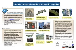
  • 1. Simple, inexpensive aerial photography mapping Project Data •Chapter: EWB-USA San Francisco Professionals •Project: Simple, Inexpensive Aerial Photography Mapping with Balloons, Kites or R/C aircraft •Location: Various In April 2010, Deepwater Horizon rig •Project phase: Demonstrated technology, available for chapters to use in exploded and sank in the Gulf of Port Sulphur Wilkinson Bay imaging Stitch of the oil spill at Chandeleur their projects Mexico - volunteer aerial mapping by the LA Bucket Brigade/Gonzo Earth Islands by Jeff Warren •Cost: As little as $100 for a complete mapping kit Community maps in Lima teams documented the spill (image by •Contact: Patrick Coyle, pat@coyles.com, belizeopensource.org Peru, Jeff Warren with children LA Bucket Brigade/Gonzo Earth) •Professional partners: and adults in community • Jeff Warren, Grassroots Mapping; grassrootsmapping.org Gulf oil spill mapping approach • Stewart Long, Gonzo Earth: gonzoearth.com •Participants visit an affected area, fill a balloon or prepare a kite •Partner organizations in local communities: depending on wind conditions, and send the camera in its • Louisiana Bucket Brigade, labucketbrigade.org homemade protective enclosure up to 2000 feet in the air • Belize Open Source - Sustainable Development, belizeopensource.org •By walking along the beach or moving in a boat, several kilometers •Name of significant donors or contributors: Numerous, see lower right of coastline may be imaged in just a few hours image with names •Between May 7 and July 22, 2010, dozens of participants made 36 trips to gather mapping data, averaging almost one trip every other day •Only one trip failed to return with imagery, 56% of the trips returned with "excellent" or "usable" data, and over 11,000 images were taken •The maps use orthorectified photographs of key affected sites Project Description processed into GeoTIFFs and tiled map services (TMS) - the public domain photographs, taken from balloons or kites, are among the A complete grassroots mapping kit by Jeff LA Bucket Brigade volunteers map with highest resolution imagery available of the spill Aerial photomaps can be very useful to EWB chapters for community, site and project planning; agricultural/ ecological planning and Warren balloons and kites •Two different manual processing methods have accounted for the evaluation bulk of the mapping for Grassroots Mapping •This poster shows how to make simple inexpensive aerial photomaps. grassrootsmapping.org to date: This approach was presented and demonstrated at the EWB West •Gonzo Earth Image Processing is a workflow of different Coast Regional Workshop in October 2010 commercial off-the-shelf (COTS) and open-source GIS and digital •What’s needed: equipment, software, supplies, materials image software packages, which has been used to generate dozens •digital camera with ability to take photos automatically of maps from balloons, kites, remote controlled and manned •GPS unit with tracking and logging capability (where needed) aircraft •A package to house the camera and GPS unit •The Cartagen Knitter software consists of a free web-based •Balloon or kite with enough lift capability to carry the camera, GPS interface for users to upload and rectify images from a web browser unit, housing and sufficient tether line to reach height of interest for the •Both export finished maps in standard formats including GeoTIFF photographs (or R/C aircraft) and TMS, to be viewed in common GIS tools and integration into •A safe approach to use the process in the field existing workflows •Capability to process the data and present the results •An approach to discuss and use the results •This poster points to web resources and an on-line Illustrated Guide •Examples are shown from community of users Belize Open Source plans to R/C aircraft testing in •We’ll demonstrate – let’s go fly! use these techniques with San Diego with pilot •Stop by after – see results, Q&A EWB chapters, schools and John Shultz •Get Involved at grassrootsmapping.org communities in Belize Mestia, in Georgia: map spans •See the Wiki for techniques and tools, case studies 5.5 kms, Jeff Warren with local •Participate: join the Mailing List! OpenMapsCaucasus staff and •Start a grassroots mapping project today! participating students •Apply techniques to your project