North america
•
0 likes•336 views

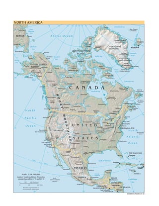
1. The document provides a map of North America showing the physical features and political boundaries of countries in the region. 2. Major physical features shown include the Arctic Ocean, Greenland Sea, mountain ranges like the Brooks Range in Alaska, and rivers such as the Mackenzie in Canada. 3. The map labels major cities, towns, and political divisions within countries in North America including Canada, the United States, Mexico, Central American countries, and the Caribbean.

Recommended
More Related Content
Similar to North america
Similar to North america (20)
More from Parminder Singh Grover
More from Parminder Singh Grover (20)
Recently uploaded
Recently uploaded (20)
North america
- 1. NORTH AMERICA 80 180 160 140 120 100 80 60 40 20 0 Nord Greenland Sea 80 160 East Jan Mayen Cherskiy Siberian (NORWAY) Sea le Arctic Ocean Circ RUSSIA Pevek Alert tic Arc Itseqqortoormiit (Scoresbysund) ICELAND Anadyr' Ellesmere Qaanaaq 20 Chukchi Island (Thule) Greenland Reykjavík Sea (DENMARK) 180 Provideniya QUEEN ELIZABETH Barrow ISLANDS Tasiilaq Denmark 60 Bering (Ammassalik) Strait Baffin Bay Strait Prudhoe Beaufort BR Nome O Bay Kangerlussuaq Sea O KS Bering RA Banks Kaujuitoq (Søndre Strømfjord) NG E Island (Resolute) Sea Nuuk UNITED STATES (Godthåb) Bethel Mt. McKinley Victoria Baffin Narsarsuaq (highest point in Fairbanks Island North America,6194 m) Inuvik Island + Davis Paamiut Yuk KA Cambridge Bay AS (Frederikshåb) RA AL Strait on 40 Anchorage Dawson Great Bear NG Lake Iqaluit E Repulse Bay Ma Arctic (Frobisher Bay) cke Valdez Circle nz Echo Bay Riv 160 Kodiak ie er Gulf of Alaska River Whitehorse Kangiqcliniq Labrador Sea Great Slave Lake Yellowknife (Rankin Inlet) Ivujivik Watson Lake Juneau Hay River C A N A D A Happy Valley- Slav er Goose Bay Riv Island of e Hudson Bay Schefferville Newfoundland River Lake e Peac Athabasca Churchill R O St. John's er Prince Rupert Riv Chisasibi Gulf of (Fort George) n lso St. Lawrence St. Pierre Ne Prince C K and Miquelon Sask George ch at (FRANCE) e er Charlottetown Edmonton wan Riv Lake Moosonee Sydney Saskatoon Winnipeg Fredericton Y Vancouver Calgary Victoria Québec Halifax River North Seattle Regina Winnipeg Thunder Bay Montréal Saint John i a 40 lu mb Lake Ottawa Co Huron 60 M O Lake Superior ES Lake Boston Pacific Misso Portland Ontario AD Toronto Lake Hamilton Lake I N S uri SC TA Michigan Erie New York Minneapolis U N Sna CA Detroit UN Milwaukee Windsor ke Rive Philadelphia U N I T E D MO r Ocean Great Salt Cleveland Baltimore S IE Chicago Pittsburgh Mi ss i ss i pp HIAN 140 Lake Washington, D.C. T A Columbus R RA Rive Sacramento Salt Lake City Indianapolis River North AC r San Francisco io Norfolk Oh St. Louis Bermuda NEV AL Denver i (U.K.) I N Kansas City r Arkan ve PP ADA sas Ri Las River Ri Atlantic A ve Vegas rado S T A T E S r Death Valley + Colo (lowest point in Memphis S North America, -86 m) Oklahoma City Atlanta Charleston Los Angeles San Diego Phoenix Albuquerque Ocean Tijuana Dallas Mexicali Jacksonville El Paso New Orleans Ri Ciudad o Juárez San Houston THE BAHAMAS Gr Antonio an de Hermosillo Miami Nassau Chihuahua Gu lf o S IE R f Trop Gulf of Mexico Cal ic RA ifor of Monterrey Havana nia MA 20 Cance Matamoros r CUBA DR La Paz Torreón HAITI E Port-au- OC MEXICO Prince CI Mazatlán D Kingston EN Tampico Cancún TA L León Mérida Guadalajara Bahía de JAMAICA Scale: 1:38,700,000 Campeche SI Lambert Conformal Conic Projection, ER RA Mexico Veracruz standard parallels 37˚N and 65˚N ISLAS BELIZE REVILLAGIGEDO MA DR E Puebla Belmopan Caribbean DE 0 300 600 Kilometers (MEXICO) LS UR Oaxaca HONDURAS Sea 0 300 600 Miles Acapulco Guatemala Tegucigalpa Boundary representation is NICARAGUA not necessarily authoritative. GUATEMALA San Salvador Managua 120 100 EL SALVADOR 80 802906AI (R02067) 6-02