SlideShare a Scribd company logo
1 of 14
Download to read offline
Cold Spring 2011 Local Waterfront Revitalization Strategy


Marathon
Description

       T    he Marathon site, which is privately owned and now vacant, is zoned as Office-
            Light Industry (OLI). The northern portion of the site (as shown in yellow on the
left side of the excerpt of the Village Zoning
District Map below) is a 6.9-acre rectangular
parcel and is bounded by The Boulevard,
Kemble Avenue, and houses on Constitution
Drive. The southern portion of the site (as
shown on the right side of the accompanying
map) is a 4.7-acre parcel bounded by Kemble,
Constitution Drive homes, and land owned by
Scenic Hudson. The southern portion of the site
overlooks Foundry Cove and the Hudson River
and contains the archaeological remains of the
home of Gouverneur Kemble, one of the
founders of the West Point Foundry.

         The Marathon site has seen turbulence
and has changed dramatically over the last six
decades. In 1952, the U.S. Department of
Defense built a battery manufacturing factory on the northern portion of the site. Around the
same time, a residential subdivision called Crestview was planned for the southern portion of
the site as well as what is today Constitution Drive. In 1962, the Sonotone Corporation bought
the factory from the government and in 1966, Sonotone bought the southern portion of the site
and constructed a parking lot and water tower. Although residences were built on Constitution
Drive in the 1950s and 1960s, no residences were ever built on the southern portion of the
Marathon site (indeed, that portion of the site was used for factory parking and drying and
burying contaminated sediment in the 1970s). In 2003, Kearney Property, Inc. purchased the
Marathon site from Gould Electronics Inc., and in 2004, the Putnam County Clerk recorded 23
deeds for lots on the southern portion of the site. In April 2011, a New York appellate court
held that the owner of one of those lots, who sought to construct a single-family residence, was
not entitled to a variance from the minimum lot area requirement applicable to parcels in the
OLI district.

       From 1952 until 1979, the battery factory discharged toxic chemicals – most notably
cadmium – into the Village sewer system and extensively contaminated the Marathon site,
Foundry Cove, Constitution Marsh, and the Hudson River. After the United States sued the
factory owners in 1970 to halt the discharge of toxic chemicals, a partial cleanup of the site
was attempted, during which the southern portion of the site was used for dewatering and
ultimately entombing contaminated material dredged from Foundry Cove. After this
remediation effort proved inadequate, in 1981, the United States Environmental Protection
Agency (EPA) declared the Marathon site a Superfund site. Additional remediation efforts
occurred over the next decade and a half. In 1996, after demolishing all structures on the
Marathon site and excavating and refilling the site (and excavating and removing sediment


                                                                                Page 119
Cold Spring 2011 Local Waterfront Revitalization Strategy

from most of Foundry Cove and the area near
the Cold Spring pier), the EPA completed its
Superfund remediation.          Deed restrictions
imposed by the EPA on the site prohibit
groundwater wells anywhere on the site and
excavation deeper than 15 feet within the
pedestal area (where a cadmium nitrate tank had
leaked into the soil), which, as shown on the
map at right, is on the eastern edge of the site
adjacent to Kemble Avenue. The EPA continues
to test soils and monitors the area to track
contamination levels. In particular, a groundwater plume of volatile organic compounds
(which are probable carcinogens, according to the EPA) currently exists under the Marathon
site, radiating from the location of an old solvent shed. Several attempts at remediation of the
plume have failed.5

        In June 2008, the EPA’s Third Five-Year Review Report on the Marathon Battery Site
raised concerns about vapor intrusion at adjacent residential properties and the delineation of
the groundwater plume. In July 2011, the EPA issued an Addendum to the 2008 Report that
contained a map of the plume showing that it underlies much of the northern portion of the
Marathon site as well as residences along Constitution Avenue. Testing wells and an indoor
air mitigation system have been installed in and around one of those homes. In the Addendum,
the EPA concluded that “[c]urrently, there are no exposure pathways that could result in
unacceptable risks.” Nevertheless, the EPA announced that it would launch a pilot program to
remediate the groundwater plume by using an air sparging technique, designed to force the
volatile organic compounds from the soil through filters and reduce their concentration to an
acceptable level.6

        The southern portion
of the Marathon site is
bounded by Kemble Ridge
(depicted at right), which
overlooks a popular walking
trail that connects the West
Point Foundry Preserve to
the Cold Spring Metro-
North station and Foundry

5
       The EPA’s Superfund Site Progress Profile for Marathon Battery, available at
http://cfpub.epa.gov/supercpad/cursites/csitinfo.cfm?id=0201491, provides a great deal of
information about the site and contains links to numerous documents, including Records of
Decision and Five-Year Reviews.
6
       According to the EPA, the levels of Trichloroethylene (TCE) in the plume range from 14
parts per billion (ppb) at the periphery to 140 ppb at the footprint of the old solvent shed.
Although the groundwater at Marathon is not (and cannot be) used for drinking water, in order to
address vapor intrusion issues, the EPA will seek to reduce concentrations of TCE to the federal
drinking water standard, which is 5 ppb.


                                                                                Page 120
Cold Spring 2011 Local Waterfront Revitalization Strategy

Cove and includes archeological remains of the home of Gouverneur Kemble, founder of the
West Point Foundry. Additionally, Kemble Ridge is visible from the Hudson River, Foundry
Cove, Constitution Marsh, Constitution Island, and the Foundry Trail. Many residents and
visitors enjoy the natural features of Kemble Ridge and consider its protection to be of vital
importance. Indeed, Cold Spring lies within a designated New York Scenic Area of Statewide
Significance (SASS),7 and one of the key features of the Cold Spring SASS is Kemble Ridge.
The SASS regulations state that “whether within or outside a designated SASS all proposed
actions subject to review under federal and State coastal acts or a Local Waterfront
Revitalization Program must be assessed to determine whether the action could affect a scenic
resource and whether the action would be likely to impair the scenic beauty of the scenic
resource.”8 The SASS policy guidelines also provide that structures and other development
should be sited back from shorelines or in other inconspicuous locations to maintain the
attractive quality of the shoreline. The comments to the SASS guidelines note that:

For much of the length of the Hudson Highlands SASS, the Hudson River is bounded by steep,
undeveloped wooded bluffs that figure prominently in views within the SASS, notably from
and across the Hudson River. Siting of structures on the slopes or crests of these bluffs, on the
immediate shoreline of the Hudson River or over the water surface of the Hudson River would
introduce discordant elements into the landscape and impair the scenic quality of the SASS.
The siting of new residential development has the potential to threaten the future visual quality
of the SASS. Areas which afford views, such as ridgelines, hilltops, and hillsides overlooking
the Hudson River, are most attractive to new development, but also the most vulnerable to
impairment from inappropriate development. The siting of residential development, structures
and other discordant features such as large buildings, highways, power lines and signs on
ridgelines, hilltops and exposed hillsides and in the direct viewshed of the Hudson River would
introduce discordant elements into the landscape and impair the scenic quality of the SASS.9

         To the south of the Marathon site lies the 87-acre West Point Foundry Preserve, which
is owned by Scenic Hudson and was recently recognized as a site of national significance
through its second listing on the National Register of Historic Places. The Cold Spring
Planning Board recently held a public hearing on Scenic Hudson’s plan for public access and
interpretation of the Foundry Preserve, which will likely increase the amount of vehicular
traffic in the area around the Marathon site. To the west of the Marathon site (on the other side
of Constitution Drive) lies the 14-acre Campbell Area, which joins the foundry site on the
National Register as part of the West Point Foundry Archaeological Site and is also owned by
Scenic Hudson. The Campbell Area is currently zoned as Multifamily Residence and consists

7
        The Cold Spring subunit of the Hudson Highlands SASS consists of “the Villages of Cold
Spring and Nelsonville, located on the east bank of the Hudson River. The southern and eastern
boundary of the subunit runs along the 20 foot contour from the northern extent of Foundry
Cove to its intersection with Foundry Brook, a common boundary with the Constitution Marsh
subunit.” See http://nyswaterfronts.com/SASS/SASS1/Hudson_Highlands.htm#HH-
25%20%20Cold%20Spring%20Subunit.
8
        See
http://nyswaterfronts.com/SASS/SASS1/Hudson_Highlands.htm#Hudson%20Highlands%20S
ubunits.
9
        See id.


                                                                                 Page 121
Cold Spring 2011 Local Waterfront Revitalization Strategy

mostly of open space, but contains the 19th-Century home of William Kemble, brother of
Gouverneur Kemble and a co-founder of the West Point Foundry. Across the street from the
Marathon site on the eastern side of Kemble Avenue are, from north to south, the Veterans of
Foreign Wars (VFW) building (which is used regularly by the Town of Philipstown and
occasionally by the Village of Cold Spring), several steep, vacant lots, a residence, and the
lower portion of a parcel owned by the Village and currently used for collecting brush.

        It is important that the Village plan for the Marathon site, the Foundry Preserve and the
Campbell Area together so as to address potential crowding and traffic issues, because
development in one area affects the others, and due to the fact that these areas are the last large
tracts of open space in the Village.

        As shown on the map below, access to the Marathon site is limited and difficult
because the roads to Marathon are narrow with mostly single-family residences on either side.
One of them, Wall Street, features a sharp turn on a steep hill, which trucks cannot navigate.
Another, Kemble Avenue, was a
narrow two-way street until it
was converted to one-way from
Rock Street to Main Street in
approximately 2002. As a one-
way street, Kemble Avenue now
provides convenient and highly
valued parking for residents
living on that street, and may
enhance safety, but it does restrict
access. Rock Street is narrow
and one-way, with residences
close to the street. A private road
winds through the Forge Gate
complex with two-way traffic
limited to residents of the
development.

        The first draft of the Comprehensive Plan, presented to the public in September 2010,
drew fire from residents of Forge Gate and Constitution Drive and others for a proposal to link
the two-way Lunn Terrace with the western end of The Boulevard. This would have run close
to, and possibly be part of, a potential parking facility east of the Metro-North station. Village
residents petitioned against the idea, and it was removed from the draft Comprehensive Plan
recommended by the Special Board to the Village Trustees in December 2010. Another
alternative access route that has been explored and rejected is what is known as the Haul Road.
This route is a steep, narrow, winding road within the Foundry Preserve linking Chestnut Street
with Kemble that was used for a time by the Superfund contractors for moving heavy
equipment (although with limited success). As part of its planned development of the Foundry
Preserve, Scenic Hudson proposed that the Haul Road be used for weekend access, as a one-
way road leading to parking to be located at the south end of Kemble. Scenic Hudson
withdrew the proposal because of local opposition and concerns about the steep grade and the


                                                                                  Page 122
Cold Spring 2011 Local Waterfront Revitalization Strategy

high cost of making the route safe for vehicles. A few other possible access routes, including a
link from Benedict to Kemble, and a link from Chestnut to Kemble, have been suggested.

Public Input
        Community input regarding the Marathon site – which led directly to the recommended
principles for future development set forth below – is reflected in the following:

    2007 Resident Survey

    2007 Community Update and Public Forum (October 20, 2007)

    2008 Stakeholder Meeting organized by the Waterfront and Open Space Working
     Group of the Special Board (September 11, 2008)

    2009 Waterfront and Open Space Committee Working Group Report (August 2009)

    2009 Special Board presentation to Village Board regarding Marathon and Foundry
     Ridge (September 8, 2009)

    2010 Forum on the Marathon Battery Site, West Point Foundry Preserve, and Campbell
     Property (May 8, 2010)

    2010 Community Forum on Marathon, Foundry Preserve and Campbell Property (May
     22, 2010)

    Public comments regarding the September 2010 Draft of the Comprehensive Plan

    2011 Community Forum on Marathon, Dockside and Village Garage (May 14, 2011)

    2011 Special Board Meeting focused on the Marathon site (May 26, 2011).

Summaries of each of these sources of input are available on the Village website at
http://www.coldspringny.gov/Pages/ColdSpringNY_BComm/lwrp.


                                                                                Page 123
Cold Spring 2011 Local Waterfront Revitalization Strategy


Alternatives
       In the Office-Light Industrial (OLI) District in which the Marathon site is located, the
following uses are currently permitted: office buildings, light industrial uses,10 storage uses,
municipal buildings, buildings for the sale of agricultural and nursery products, storage, and
one-family residences. The minimum lot size in the OLI District (including residences) is
40,000 square feet per lot, which is about .91 acre.11

                                                                           In the survey of Village
                                                                  residents conducted in 2007
                                                                  (see summary chart at left), in
                                                                  response to the question of
                                                                  what uses should be considered
                                                                  for the Marathon site, 45% of
                                                                  respondents said parking, 17%
                                                                  said active recreation (such as a
                                                                  swimming pool, skate park,
                                                                  skating rink, track and ball
                                                                  fields), 14% said open space
                                                                  (either keep the site as is or
                                                                  have passive uses such as a
                                                                  wildflower        meadow       or
                                                                  gardens), 8% said housing, 3%
                                                                  said community center (such as
                                                                  seniors, teens, pool, or a gym),
and 13% specified another use (such as a dog run, conference center, green center, shopping).
Although in the survey and in the October 2007 public forum many residents identified public
parking as a desired use for the Marathon site, in forums held in May 2010 and May 2011,
there was much less support for creating parking areas at Marathon that are not secondary to
uses at the site. At these latter forums, while there was support for a mix of limited residential
development and some commercial development, many residents expressed strong concerns
that development would cause increased traffic and disruption to the area. Also at these latter
forums, residents strongly expressed their desire that development at Marathon be consistent
with the Village character and reflect the historical nature of the site and the Village.

       Generally, residents living close to the Marathon site prefer that no development be
permitted, or that the current industrial zoning remain, to limit residences to no more than one
house per acre. Some Village residents have expressed support for light industrial and

10
         These uses may include “manufacturing, assembling, which operation, in the opinion of
the Planning Board, will not create any dangerous, injurious, noxious or otherwise objectionable
fire, explosive, radioactive or other hazard, noise or vibration, smoke, dust, odor or other form of
air pollution, electromagnetic or other disturbance, glare, harmful discharge, storage or dispersal of
liquid or solid wastes in a manner or amount as to adversely affect the surrounding area.” Cold
Spring Zoning Law § 134-12(B)(7). All buildings and uses proposed for the OLI District require
site plan review by the Planning Board. Cold Spring Zoning Law § 134-12(A).
11
         See Cold Spring Zoning Law § 134-12(D)(1).


                                                                                     Page 124
Cold Spring 2011 Local Waterfront Revitalization Strategy

commercial development, along with live/work uses, perhaps reflecting the manufacturing
past. Local residents have also expressed serious concerns about contamination related to the
battery factory. There is strong opposition to relocating the village garage to the Marathon
property, even on land where contamination is still an issue, due the proximity of existing
residences. Community residents have expressed strong support for protecting Kemble Ridge
and opposition to building houses on the ridge.

        Over the last several years, the current owner of the Marathon site has presented a
series of conceptual drawings to the Village Board and the Special Board. 12 It is important to
emphasize that, while these drawings may resemble blueprints, they are not actual plans and
were presented only for discussion purposes. Also, implementation of the concepts embodied
in these drawings would likely require rezoning of the Marathon site, extensive further study,
and Planning Board approval. The drawings depict either only residential development, only
commercial development, or a mix of residential and commercial development:

      In terms of residential development, some of the drawings presented by the current
       owner of the Marathon site to the Village Board in 2009 show residential lots on the
       southern portion of the site extending to and covering Kemble Ridge, with between 14
       and 23 residential lots ranging in size from 14-.44 acre. Other drawings show, for the
       northern portion of the site, between 22 and 38 townhouses, two single family lots of .5
       acre each, a 2.1 acre lot for future development, an 89-space parking lot and 3.1 acres
       to be dedicated to the Village (including a stormwater and infrastructure reservation
       area).

      In terms of commercial development, a drawing for the northern portion of the site
       presented by the current owner of the Marathon site to the Village Board in 2009 shows
       an industrial park that includes two two-story buildings with basements providing
       office, manufacturing and warehouse facilities comprising a total of 28,500 square feet
       of space, four one-story storage buildings comprising a total of 18,750 square feet with
       additional exterior storage space, a vacant lot of 2.05 acres for “future development,”
       and a building materials, sales and storage structure containing 16,050 square feet.
       Each building has its own parking area.

      In terms of mixed-used development, the current owner of the Marathon site presented
       drawings to the Special Board in May 2011 showing an acre-sized park in the northeast
       corner, between 18 and 21 single-family residences along the western and southern
       edges of the entire site, between 16 and 24 live-work spaces arranged in three rows of
       eight each running east to west between the southern single-family residences and a
       large parking lot, and large commercial/industrial buildings to the north of the parking
       lot and to the south of the park. The commercial/industrial buildings could be occupied
       by craftsmen and artisans. The drawings also show a roadway going from the
       Boulevard at the northwest corner of the site to Kemble Avenue at the south east corner
       of the site. Community residents expressed some support for these concepts, but also

12
       These drawings are available on the Village website at
http://www.coldspringny.gov/pages/ColdSpringNY_BComm/2011_community_workshops/20
11_community_workshops.


                                                                               Page 125
Cold Spring 2011 Local Waterfront Revitalization Strategy

       voiced serious concerns about crowding and traffic impacts. The current owner of the
       Marathon site stated at the May 26, 2011 Special Board meeting that current zoning
       would allow a 95,000 square foot footprint on the southern portion of the site, which
       could comprise approximately 250,000 square feet of self-storage space. He added that
       the Marathon site as a whole could contain approximately 300,000 square feet of
       storage, but it is unclear whether the market could support such an amount of storage.
       He also said that he does not wish to build single-family houses on one-acre lots, which
       would be permitted under current zoning.

        At the May 2011 public forum on Marathon (which preceded the presentation by the
current owner of the Marathon site to the Special Board later that month), the Special Board
presented for discussion purposes a conceptual rendering it had commissioned that showed a
acre-sized park in the northeast corner of the site, a large parking lot, five large commercial
structures abutting the park, 12 single-family homes (including several near the ridge with a
narrow conservation easement), a potential site for the Village garage, and five lots left open in
the plume area. Although some forum attendees supported the concept of limited commercial
and residential development, others were opposed to any development, and most attendees
were strongly opposed to development on Kemble Ridge and to relocation of the Village
Garage to Marathon.

        In June 2011, Village resident Peter Henderson submitted a conceptual drawing to the
Special Board that included two single-acre light industrial/commercial lots at the northern end
of the property and ten single-family lots, each 7500 square feet, either all on Kemble in a row
or on a loop road towards the southern end of property. In Mr. Henderson’s drawing, Kemble
Ridge was left as open space.

       Also in June 2011, Village resident James Hartford submitted a conceptual drawing to
the Special Board showing the Village Garage maintenance building on the parcel of Village
property at eastern side of the southern end of Kemble Avenue adjacent to the Foundry, with a
small park on top of the ridge at the end of Benedict Road and stairs leading to/from Benedict
Road and Kemble Avenue. In addition to the opposition from local residents to relocating
Village Garage functions to a residential neighborhood, it is unclear whether the Village-
owned parcel could accommodate the functions and the vehicles that would need to access the
site.


                                                                                  Page 126
Cold Spring 2011 Local Waterfront Revitalization Strategy


Recommended Principles for Future Development
       The following principles – based on public comments received over the last four years
and sound planning practice – should guide land use decisions at Marathon, and should provide
a framework for a comprehensive, rather than a piecemeal, approach:

     •   Development should not cause congestion or overcrowding. One of the most
         commonly expressed concerns about future development at Marathon is that it will
         create traffic problems that diminish the quality of life of current residents of the area
         (which includes Forge Gate, Constitution Drive, Rock Street, Kemble Avenue, and The
         Boulevard), many of whom have small children. Additionally, residents have
         expressed concerns that during any construction, trucks may create a nuisance.
         Accordingly, prior to any development, an independent traffic study with quantitative
         and qualitative elements should be performed to assess the impact of the planned
         development. An independent traffic study should also be performed to investigate
         alternative access routes to the area, and should address issues related to car, truck,
         pedestrian and bicycle access, as well as parking. The Village should also review
         performance standards to minimize traffic and noise disturbance, noxious fumes, and
         other nuisances, including limiting truck access by route, size and time. Measures that
         would promote walkability – such as adding sidewalks and creating attractive
         streetscapes with buildings close to the street – should be encouraged and explored.
         Mitigation measures to reduce the number of cars entering and exiting the Marathon
         site could also include limiting the number of residential units, or constructing
         residential units that would have occupants who would be less likely to rely heavily on
         cars, such as live-work or work-live units.13

     •   Development should be tax-positive. Many Village residents have expressed concerns
         that large-scale residential development at Marathon would increase the financial
         burden on the Haldane School District and the Village, resulting in increased property
         taxes. To address these concerns, the Village can employ a widely used planning tool
         known as fiscal impact analysis to evaluate the tax impact of new development by
         comparing costs and revenues from new development. Fiscal impact analysis
         recognizes that businesses and residences generate additional revenue but also create
         new costs via new roads, sewers, police and fire protection, and more children in
         schools (requiring teachers and even new school buildings). If new revenues exceed
         new costs, the fiscal impact is said to be positive. On the other hand, if new costs
         exceed new revenues, the local government must raise taxes to meet new service
         demands or reduce the quantity or quality of existing services. Studies have shown that
         commercial development is generally tax positive, while residential development is
         generally tax negative.14 To ensure that development at Marathon is tax positive, any

13
        In general, work activities in live/work units are those that are compatible with residential
occupancies, such as offices, but not manufacturing, whereas work activities in work/live units are
the dominant pursuit of the occupants, and may include moderate and low-hazard assembly,
fabricating, manufacturing, repair or processing.
14
        According to available data, residences in Philipstown cost the municipality approximately
$1.20 for every tax dollar generated, while commercial development costs the municipality 30


                                                                                    Page 127
Cold Spring 2011 Local Waterfront Revitalization Strategy

       application for development at this site should be accompanied by a fiscal impact
       analysis (perhaps as part of the State Environmental Quality Review (SEQR) process)
       to ascertain the potential fiscal impacts associated with all increased service demands
       generated by development. Using generally accepted methodology, the fiscal impact
       analysis would measure the cost and revenue implications of the project for the Cold
       Spring, Philipstown, and Haldane taxing districts. The analysis should include a no-
       action alternative to the proposal and should explore mitigation measures that minimize
       any adverse fiscal impact, both immediate and long-term, of the development. The
       analysis should also consider the form of ownership for proposed residential units at
       Marathon (fee simple or condominium ownership) and evaluate the impacts resulting
       from the potential unequal tax burden on fee simple owners created by condominium
       ownership, and fee simple ownership for all proposed residential units should
       be considered as a mitigation measure. The current owner of the Marathon site has
       stated that the conceptual plans he presented in May 2011, embodying a “village with
       the village,” would balance residential and commercial uses to generate positive
       rateables, and would also improve property values in the surrounding areas. Another
       important aspect of the fiscal impact analysis would be to evaluate the impact of
       development on infrastructure, including water and sewerage, to ensure that
       development will not exceed the Village’s carrying capacity. The current owner of the
       Marathon site has stated that the Village sewer system in the Marathon area (built in the
       1970s) has the capacity to handle the conceptual plans he presented in May 2011, but
       this would need to be confirmed.

   •   Development should provide for a mix of uses.
       Although some residents have stated that they do
       not want to see anything built on Marathon, others
       have said that they want controlled and reasonable
       development that would promote the economic
       health of the Village while retaining Village
       character and minimizing the tax burden.       The
       latter group, as well as the current owner of the
       Marathon site, support a mix of uses that could
       include commercial, residential and public open
       space. As shown in the photograph at right, many
       buildings on Main Street currently have a mixed-
       use character, with commercial space on the ground
       floor and residences on upper floors. Each of the
       potential uses for Marathon will be discussed in
       turn:

        Residential units. Although many residents have expressed concerns about
         residential development, there has been support for live-work units, which have

cents for every tax dollar it generates, and open space generates about 20 cents on the dollar. See
“Pointers for Economic Development,” created in 2002 for the Philipstown Comprehensive Plan
Special Board by consultant Phillips Preiss Shapiro, at page 33, available at
http://philipstown.com/shapiroReport.pdf.


                                                                                  Page 128
Cold Spring 2011 Local Waterfront Revitalization Strategy

          been defined as “a single unit (e.g., studio, loft, or one bedroom) consisting of both
          a commercial/office and a residential component that is occupied by the same
          resident.”15 Live-work units encourage less reliance on cars, and may be more
          suitable for adults without children, resulting in a tax-positive outcome. Live/work
          unit regulations can carry numerous restrictions, for example that “the live/work
          unit shall be the primary dwelling of the occupant,” that “the residential and the
          commercial space must be occupied by the same tenant, and no portion of the
          live/work unit may be rented or sold separately,” and that “the commercial use shall
          not generate vehicular traffic, in excess of normal residential traffic, which will
          interfere with residential traffic circulation or shall not cause more than three
          vehicles including vehicles used by customers, vendors, or delivery services to visit
          the premises per day.”16 Residents have expressed support for live/work units as
          potentially conducive to artists and artisans and home occupations. Some residents
          have suggested that more people working at home would increase the number of
          people in the Village during the day, which could increase the amount of money
          residents spend in the Village and reduce the use of cars. It could also contribute to
          a safer neighborhood as people working at home keep an eye on the street. The
          current owner of the Marathon site has stated that the conceptual plans he presented
          in May 2011 embody more of an urban concept than a suburban concept, which is
          in keeping with the village character, and that live-work spaces (with the second
          floor as a loft) would be more suitable for adults than for families, and that he does
          not believe that single-family homes on one-acre lots are consistent with the village
          character. Also, because Village residents have expressed a desire to have more
          senior housing in the Village, it would be advisable to explore the possibility of
          including in any residential development at Marathon some accessible units.

       Commercial development. There has also been some support for commercial
        development, to encourage small businesses that would be tax positive, could
        provide jobs to Village residents, and would have low impact on the community in
        terms of traffic and noise. In particular, there has been support for the possibility of
        attracting scalable technology, research, design, communications, “clean” light
        industrial, or “green” companies that could employ Village residents, so long they
        are low-profile. Such companies could be engaged in pursuits as varied as jewelry-
        making, glassblowing, or the manufacture of medical devices such as prosthetics.
        Although there appears to be demand for non-retail commercial space within the
        Village, there is not much support (or apparent demand) for additional retail space,
        although craft/repair shops could have an ancillary retail component. Many
        residents have expressed the view that non-retail commercial space should
        complement Main Street, not compete with it, and provide opportunities for
        Village/local entrepreneurs and workers. The current owner of the Marathon site
        has stated that he would consider commercial development that could attract
        artisans.


15
       See Sunnyvale Municipal Code, Section 19.26.230 (“Live/work units”), available at
http://qcode.us/codes/sunnyvale/.
16
       See id.


                                                                                Page 129
Cold Spring 2011 Local Waterfront Revitalization Strategy

        Public open space. Many residents strongly support the reservation of a portion of
         the Marathon site as public open space. Indeed, the drawings commissioned by the
         Special Board and the drawings presented by the current owner of the Marathon site
         in May 2011 include a small park at the northeast corner of the site, as a “gateway”
         or Village green. Although some residents have advocated other community
         amenities, such as a theater, galleries, a community pool, playing fields, and dog
         run, concerns have been raised about the impact of these uses on neighboring
         residences in terms of traffic and noise.

   •   Development should preserve the scenic viewshed of Kemble Ridge. Village residents
       overwhelmingly support protecting views of Kemble Ridge, which is identified as a
       contributing feature of the Cold Spring Scenic Area of Statewide Significance (SASS).
       Local enforcement of the SASS policies during Planning Board review of any
       development proposed in this area is critical. Also of great concern is the protection of
       the archaeological resources on the Marathon site, and an archaeological survey should
       be required during the SEQR review of any application for development proposed in
       this area. One significant planning technique that could be used to conserve scenic and
       archaeological resources while allowing for development is conservation subdivision,
       which employs a four-step design process to identify unbuildable lands and special
       features of the site around which development is designed, and where a minimum
       amount of protected open space is required. In this case, the ridgeline and
       archaeological sites could be identified as areas to preserve, and the open space lands
       could be placed under a conservation easement to permanently protect them. The
       current owner of the Marathon site has stated that he is willing to work with Scenic
       Hudson, which might hold the conservation easement, regarding protection of Kemble
       Ridge.

   •   Development should proceed only after the satisfactory remediation of environmental
       contamination. Residents are quite concerned about issues related to the VOC plume
       on existing residences, and the impact of the plume on potential residents or occupants
       of the site. In July 2011, the EPA announced a pilot program to remediate the VOCs
       using air sparging and soil vapor extraction and issued an addendum to the Third Five-
       Year Review Report on the Marathon Battery site. The EPA expects the pilot program
       to begin before the end of 2011, although it is not known when the program will be
       complete. After the EPA-directed remediation
       project is completed, a thorough study and
       remediation of contaminants at the site should
       be performed to assess future risks before
       development begins. Future occupants of the
       Marathon site should be made aware of the past
       contamination issues, and structures should
       contain active indoor air mitigation systems.

   •   Development should be green. Many Village
       residents are quite concerned about protecting
       the natural environment and would like to see
       greater use of green building and landscaping techniques in the Village. The Marathon


                                                                                Page 130
Cold Spring 2011 Local Waterfront Revitalization Strategy

       site could serve as a model for state-of-the-art energy-efficient design elements, uses of
       alternative energy sources such as solar and geothermal, and innovative landscaping
       techniques to control stormwater. The Marathon site is downhill from a large
       imperviously surfaced area at the Village’s commercial plaza, which causes serious
       stormwater issues after heavy rains. To control stormwater, development at Marathon
       should utilize green infrastructure techniques as indicated in the New York State
       Stormwater Management Design Manual (2010): green roofs (as shown in the photo at
       right of the Chancery Building at the Chapel of Our Lady Restoration), reducing
       impervious surfaces, using soil and vegetation within a shallow depression to manage
       and treat small volumes of rainwater, bioretention areas, vegetated swales, porous
       pavement, and rain barrels or cisterns. New development should also meet ENERGY
       STAR, LEED (Leadership in Energy and Environmental Design) or other similar
       standards. Additionally, new development should use low-wattage, fully shielded
       lighting to improve energy conservation, visibility and public safety, while minimizing
       light pollution. The current owner of the Marathon site has stated that he is interested
       in obtaining LEED certification for structures at Marathon and that rain gardens could
       be used to manage stormwater at the site.

   •   Development should employ design elements consistent with the village character.
       Residents have expressed their desire that buildings constructed at the Marathon site,
       which is located within the Local
       Historic District, be consistent with the
       historical character of the Village, as
       depicted in the photograph at right of a
       Main Street entryway. Site layout
       should give prominence to pedestrians,
       rather than being oriented towards the
       automobile, with buildings located
       close to the street and to each other,
       and parking located behind buildings.
       Design standards should be adopted to
       ensure that new development in this
       area incorporates the features of
       traditional village neighborhoods. The
       current owner of the Marathon site has stated that, in view of the Village’s industrial
       past, he would explore the idea of an industrial “look” to development at Marathon.

   •   Development should maximize Kemble Avenue south of the Boulevard as a pathway.
       Residents have expressed their desire to preserve the “small-town” streetscape of
       Kemble Avenue, and to create an attractive walking and bicycle path from Main Street
       down to the Foundry Preserve, with places to stop and sit. Such a path, which would
       include sidewalks and shade trees (as shown in the photo of Main Street above) and
       possibly benches, could tie together Main Street and the Foundry and would remind
       people of the industrial heritage of the Village. Additionally, if the lots on the eastern
       side of Kemble are developed (or, in the case of the VFW building, redeveloped), both
       sides of Kemble should have similar characteristics, in terms of setbacks and building
       height.


                                                                                 Page 131
Cold Spring 2011 Local Waterfront Revitalization Strategy

     •   Parking should be secondary to main uses and hidden from streets. Many residents
         wish to avoid the unsightliness and pollution of parking lots by ensuring that parking
         areas are not visible from streets. Generally, only sufficient parking that is necessary
         for future uses should be created, and such areas
         should be hidden from view (as shown in the
         photo at right of the parking area behind the
         waterfront condominiums) and have pervious
         surfaces. Although in the past some Village
         residents have considered a parking lot as a
         desirable use for a portion of the Marathon site,
         the site has been rejected by Metro-North as a
         feasible location for commuter parking (because
         it is too far from the train station and such
         parking would not be visible from the platform)
         and is not realistic for Main Street parking
         (because patrons of Main Street businesses would be unlikely to park several blocks
         away).17 Additionally, a parking study conducted by the Special Board in 2008
         concluded that there is ample parking in the Village such that there is no “parking
         problem” but rather a “convenience problem” on Main Street at peak times such as
         weekend afternoons (which can be addressed by measures such as charging for on-
         street parking rather than building more parking lots). Moreover, building a parking lot
         at Marathon could create more traffic in the surrounding area, a situation that many
         residents wish to avoid. Notwithstanding these issues, a small winter parking area
         could be set aside to replace the current winter parking strip along Kemble. The current
         owner of the Marathon site has stated that he is in favor of siting parking areas behind
         buildings.

     Photos: Page 120 view of Kemble Ridge from Foundry Cove; Page 128, shops on Main
        Street; Page 130, green-roofed Chancery Building, new annex to Cold Spring’s Chapel
        Restoration; Page 131, Main Street entryway; Page 132, cars parked behind the Cold
        Spring Landing condominiums.


17
       The planning firm Phillips Preiss & Shapiro has expressed strong skepticism that parking
at Marathon could alleviate the perceived parking problem in Cold Spring:
                Remote parking (at, for instance, the Marathon Battery site) is a mirage.
       Remote parking is most successful in places like Disneyland where there is a
       compelling reason to forego the convenience of the car. Instead, merchants should be
       induced to park on the periphery of downtown. With two employees per store, and
       since they arrive before shoppers, Main Street merchants otherwise preempt
       something like 60 of the most convenient parking spaces. Parking space regulations
       should be carefully calibrated mindful of the need to assure parking turnover, yet
       allow long enough parking for browsing and dining. This would argue for
       something like three-hour parking.
“Pointers      for    Economic        Development,”      at     p.    37,    available   at
http://philipstown.com/shapiroReport.pdf.


                                                                                 Page 132

More Related Content

What's hot

Andy Freifeld, Temple University, “Landscape Design and Reuse Planning in Min...
Andy Freifeld, Temple University, “Landscape Design and Reuse Planning in Min...Andy Freifeld, Temple University, “Landscape Design and Reuse Planning in Min...
Andy Freifeld, Temple University, “Landscape Design and Reuse Planning in Min...Michael Hewitt, GISP
 
Jen Giattino anfd Tiffanie Fisher letter to NJDEP re: Union Dry Dock
Jen Giattino anfd Tiffanie Fisher letter to NJDEP re: Union Dry DockJen Giattino anfd Tiffanie Fisher letter to NJDEP re: Union Dry Dock
Jen Giattino anfd Tiffanie Fisher letter to NJDEP re: Union Dry DockHoboken Resistance
 
IID ASCE_Red Hill Bay projecy-10.26a.16
IID ASCE_Red Hill Bay projecy-10.26a.16IID ASCE_Red Hill Bay projecy-10.26a.16
IID ASCE_Red Hill Bay projecy-10.26a.16Graeme Donaldson
 
Amy Wolfe, Trout Unlimited, "A Decade of Progress for the West Branch Susqueh...
Amy Wolfe, Trout Unlimited, "A Decade of Progress for the West Branch Susqueh...Amy Wolfe, Trout Unlimited, "A Decade of Progress for the West Branch Susqueh...
Amy Wolfe, Trout Unlimited, "A Decade of Progress for the West Branch Susqueh...Michael Hewitt, GISP
 
Banks Property Stream Restoration (DC9218)
Banks Property Stream Restoration (DC9218)Banks Property Stream Restoration (DC9218)
Banks Property Stream Restoration (DC9218)Fairfax County
 
Dizak, Earth Conservancy, "AMD Treatment Alternatives and Reclamation of Mine...
Dizak, Earth Conservancy, "AMD Treatment Alternatives and Reclamation of Mine...Dizak, Earth Conservancy, "AMD Treatment Alternatives and Reclamation of Mine...
Dizak, Earth Conservancy, "AMD Treatment Alternatives and Reclamation of Mine...Michael Hewitt, GISP
 
Indian Run at Indian Run Court Stream Restoration
Indian Run at Indian Run Court Stream RestorationIndian Run at Indian Run Court Stream Restoration
Indian Run at Indian Run Court Stream RestorationFairfax County
 
PPL26 Bayou La Loutre Ridge & Marsh Restoration Nomination Fact Sheet for 1_8_16
PPL26 Bayou La Loutre Ridge & Marsh Restoration Nomination Fact Sheet for 1_8_16PPL26 Bayou La Loutre Ridge & Marsh Restoration Nomination Fact Sheet for 1_8_16
PPL26 Bayou La Loutre Ridge & Marsh Restoration Nomination Fact Sheet for 1_8_16Blaise Pezold
 
Designing a Geo-Ecology and Education nature trail by Florian Hopp (North Ame...
Designing a Geo-Ecology and Education nature trail by Florian Hopp (North Ame...Designing a Geo-Ecology and Education nature trail by Florian Hopp (North Ame...
Designing a Geo-Ecology and Education nature trail by Florian Hopp (North Ame...Quarry Life Award by HeidelbergCement
 
AZ Mining Report
AZ Mining ReportAZ Mining Report
AZ Mining ReportDavid Moyer
 
Dead Run Stream Restoration Public meeting February 18, 2015
Dead Run Stream Restoration Public meeting February 18, 2015Dead Run Stream Restoration Public meeting February 18, 2015
Dead Run Stream Restoration Public meeting February 18, 2015Fairfax County
 
Dead Run Stream Restoration Public Meeting June 9, 2015
Dead Run Stream Restoration Public Meeting June 9, 2015Dead Run Stream Restoration Public Meeting June 9, 2015
Dead Run Stream Restoration Public Meeting June 9, 2015Fairfax County
 
Northampton Landfill Waiver from DEP 06-23-2006
Northampton Landfill Waiver from DEP 06-23-2006Northampton Landfill Waiver from DEP 06-23-2006
Northampton Landfill Waiver from DEP 06-23-2006Adam Cohen
 
Sequoia Park Pond Retrofit Project
Sequoia Park Pond Retrofit ProjectSequoia Park Pond Retrofit Project
Sequoia Park Pond Retrofit ProjectFairfax County
 
Feasibility Report - CREDM
Feasibility Report - CREDMFeasibility Report - CREDM
Feasibility Report - CREDMWilliam Grogan
 
Tripps Run Stream Improvement
Tripps Run Stream ImprovementTripps Run Stream Improvement
Tripps Run Stream ImprovementFairfax County
 
Royal Lake Dredging and Restoration Project: Pardon Our Dust Meeting May 9, 2016
Royal Lake Dredging and Restoration Project: Pardon Our Dust Meeting May 9, 2016Royal Lake Dredging and Restoration Project: Pardon Our Dust Meeting May 9, 2016
Royal Lake Dredging and Restoration Project: Pardon Our Dust Meeting May 9, 2016Fairfax County
 
Community Vision Plan for the Palisades Nature Preserve
Community Vision Plan for the Palisades Nature PreserveCommunity Vision Plan for the Palisades Nature Preserve
Community Vision Plan for the Palisades Nature PreserveAPA-NJ
 
Rothwell_Country_Park_Management_Plan_20
Rothwell_Country_Park_Management_Plan_20Rothwell_Country_Park_Management_Plan_20
Rothwell_Country_Park_Management_Plan_20Shiloh Covey
 

What's hot (20)

Andy Freifeld, Temple University, “Landscape Design and Reuse Planning in Min...
Andy Freifeld, Temple University, “Landscape Design and Reuse Planning in Min...Andy Freifeld, Temple University, “Landscape Design and Reuse Planning in Min...
Andy Freifeld, Temple University, “Landscape Design and Reuse Planning in Min...
 
Jen Giattino anfd Tiffanie Fisher letter to NJDEP re: Union Dry Dock
Jen Giattino anfd Tiffanie Fisher letter to NJDEP re: Union Dry DockJen Giattino anfd Tiffanie Fisher letter to NJDEP re: Union Dry Dock
Jen Giattino anfd Tiffanie Fisher letter to NJDEP re: Union Dry Dock
 
IID ASCE_Red Hill Bay projecy-10.26a.16
IID ASCE_Red Hill Bay projecy-10.26a.16IID ASCE_Red Hill Bay projecy-10.26a.16
IID ASCE_Red Hill Bay projecy-10.26a.16
 
Amy Wolfe, Trout Unlimited, "A Decade of Progress for the West Branch Susqueh...
Amy Wolfe, Trout Unlimited, "A Decade of Progress for the West Branch Susqueh...Amy Wolfe, Trout Unlimited, "A Decade of Progress for the West Branch Susqueh...
Amy Wolfe, Trout Unlimited, "A Decade of Progress for the West Branch Susqueh...
 
Banks Property Stream Restoration (DC9218)
Banks Property Stream Restoration (DC9218)Banks Property Stream Restoration (DC9218)
Banks Property Stream Restoration (DC9218)
 
Dizak, Earth Conservancy, "AMD Treatment Alternatives and Reclamation of Mine...
Dizak, Earth Conservancy, "AMD Treatment Alternatives and Reclamation of Mine...Dizak, Earth Conservancy, "AMD Treatment Alternatives and Reclamation of Mine...
Dizak, Earth Conservancy, "AMD Treatment Alternatives and Reclamation of Mine...
 
Indian Run at Indian Run Court Stream Restoration
Indian Run at Indian Run Court Stream RestorationIndian Run at Indian Run Court Stream Restoration
Indian Run at Indian Run Court Stream Restoration
 
PPL26 Bayou La Loutre Ridge & Marsh Restoration Nomination Fact Sheet for 1_8_16
PPL26 Bayou La Loutre Ridge & Marsh Restoration Nomination Fact Sheet for 1_8_16PPL26 Bayou La Loutre Ridge & Marsh Restoration Nomination Fact Sheet for 1_8_16
PPL26 Bayou La Loutre Ridge & Marsh Restoration Nomination Fact Sheet for 1_8_16
 
Designing a Geo-Ecology and Education nature trail by Florian Hopp (North Ame...
Designing a Geo-Ecology and Education nature trail by Florian Hopp (North Ame...Designing a Geo-Ecology and Education nature trail by Florian Hopp (North Ame...
Designing a Geo-Ecology and Education nature trail by Florian Hopp (North Ame...
 
AZ Mining Report
AZ Mining ReportAZ Mining Report
AZ Mining Report
 
Dead Run Stream Restoration Public meeting February 18, 2015
Dead Run Stream Restoration Public meeting February 18, 2015Dead Run Stream Restoration Public meeting February 18, 2015
Dead Run Stream Restoration Public meeting February 18, 2015
 
Dead Run Stream Restoration Public Meeting June 9, 2015
Dead Run Stream Restoration Public Meeting June 9, 2015Dead Run Stream Restoration Public Meeting June 9, 2015
Dead Run Stream Restoration Public Meeting June 9, 2015
 
Northampton Landfill Waiver from DEP 06-23-2006
Northampton Landfill Waiver from DEP 06-23-2006Northampton Landfill Waiver from DEP 06-23-2006
Northampton Landfill Waiver from DEP 06-23-2006
 
A chronology of development on the current river
A chronology of development on the current river A chronology of development on the current river
A chronology of development on the current river
 
Sequoia Park Pond Retrofit Project
Sequoia Park Pond Retrofit ProjectSequoia Park Pond Retrofit Project
Sequoia Park Pond Retrofit Project
 
Feasibility Report - CREDM
Feasibility Report - CREDMFeasibility Report - CREDM
Feasibility Report - CREDM
 
Tripps Run Stream Improvement
Tripps Run Stream ImprovementTripps Run Stream Improvement
Tripps Run Stream Improvement
 
Royal Lake Dredging and Restoration Project: Pardon Our Dust Meeting May 9, 2016
Royal Lake Dredging and Restoration Project: Pardon Our Dust Meeting May 9, 2016Royal Lake Dredging and Restoration Project: Pardon Our Dust Meeting May 9, 2016
Royal Lake Dredging and Restoration Project: Pardon Our Dust Meeting May 9, 2016
 
Community Vision Plan for the Palisades Nature Preserve
Community Vision Plan for the Palisades Nature PreserveCommunity Vision Plan for the Palisades Nature Preserve
Community Vision Plan for the Palisades Nature Preserve
 
Rothwell_Country_Park_Management_Plan_20
Rothwell_Country_Park_Management_Plan_20Rothwell_Country_Park_Management_Plan_20
Rothwell_Country_Park_Management_Plan_20
 

Viewers also liked

Open Minds speakers series
Open Minds speakers seriesOpen Minds speakers series
Open Minds speakers seriesWaterfrontTO
 
Roberto Clemente State Park Revitalization Plan
Roberto Clemente State Park Revitalization PlanRoberto Clemente State Park Revitalization Plan
Roberto Clemente State Park Revitalization Plancwestory
 
Market and community center at the 22@ District in Barcelona
Market and community center at the 22@ District in BarcelonaMarket and community center at the 22@ District in Barcelona
Market and community center at the 22@ District in BarcelonaTomeu Duran Gelabert
 
East Side Bridgeport Neighborhood Revitalization Zone presentation
East Side Bridgeport Neighborhood Revitalization Zone presentationEast Side Bridgeport Neighborhood Revitalization Zone presentation
East Side Bridgeport Neighborhood Revitalization Zone presentationCity of Bridgeport, Connecticut
 
Portfolio
Portfolio Portfolio
Portfolio kthoures
 
Sagarika patil academic portfolio
Sagarika patil academic portfolioSagarika patil academic portfolio
Sagarika patil academic portfolioSagarikapatil321
 
A City with a Soul... growing smartly (CIS) | Amman Institute
A City with a Soul... growing smartly (CIS) | Amman InstituteA City with a Soul... growing smartly (CIS) | Amman Institute
A City with a Soul... growing smartly (CIS) | Amman InstituteAmman Institute
 
Mapping Social Dispariteis in Amman | Amman Instituite
Mapping Social Dispariteis in Amman | Amman Instituite Mapping Social Dispariteis in Amman | Amman Instituite
Mapping Social Dispariteis in Amman | Amman Instituite Amman Institute
 
Amman Downtown Plan & Revitalization Strategy | Amman Institute
Amman Downtown Plan & Revitalization Strategy | Amman InstituteAmman Downtown Plan & Revitalization Strategy | Amman Institute
Amman Downtown Plan & Revitalization Strategy | Amman InstituteAmman Institute
 

Viewers also liked (11)

Dania Beach’s Waterfront Revitalization Plan
Dania Beach’s Waterfront Revitalization PlanDania Beach’s Waterfront Revitalization Plan
Dania Beach’s Waterfront Revitalization Plan
 
Open Minds speakers series
Open Minds speakers seriesOpen Minds speakers series
Open Minds speakers series
 
Roberto Clemente State Park Revitalization Plan
Roberto Clemente State Park Revitalization PlanRoberto Clemente State Park Revitalization Plan
Roberto Clemente State Park Revitalization Plan
 
Market and community center at the 22@ District in Barcelona
Market and community center at the 22@ District in BarcelonaMarket and community center at the 22@ District in Barcelona
Market and community center at the 22@ District in Barcelona
 
East Side Bridgeport Neighborhood Revitalization Zone presentation
East Side Bridgeport Neighborhood Revitalization Zone presentationEast Side Bridgeport Neighborhood Revitalization Zone presentation
East Side Bridgeport Neighborhood Revitalization Zone presentation
 
Architecture Design (1)
Architecture Design  (1)Architecture Design  (1)
Architecture Design (1)
 
Portfolio
Portfolio Portfolio
Portfolio
 
Sagarika patil academic portfolio
Sagarika patil academic portfolioSagarika patil academic portfolio
Sagarika patil academic portfolio
 
A City with a Soul... growing smartly (CIS) | Amman Institute
A City with a Soul... growing smartly (CIS) | Amman InstituteA City with a Soul... growing smartly (CIS) | Amman Institute
A City with a Soul... growing smartly (CIS) | Amman Institute
 
Mapping Social Dispariteis in Amman | Amman Instituite
Mapping Social Dispariteis in Amman | Amman Instituite Mapping Social Dispariteis in Amman | Amman Instituite
Mapping Social Dispariteis in Amman | Amman Instituite
 
Amman Downtown Plan & Revitalization Strategy | Amman Institute
Amman Downtown Plan & Revitalization Strategy | Amman InstituteAmman Downtown Plan & Revitalization Strategy | Amman Institute
Amman Downtown Plan & Revitalization Strategy | Amman Institute
 

Similar to Marathon Section of Cold Spring LWRS

Compressor
Compressor Compressor
Compressor umedrind
 
coastalrestoration
coastalrestorationcoastalrestoration
coastalrestorationAnne Roberts
 
2008 restoration conference article
2008 restoration conference article2008 restoration conference article
2008 restoration conference articlesvandegrift
 
Ayb Colorado River
Ayb Colorado RiverAyb Colorado River
Ayb Colorado Riverbickay
 
30th Street Industrial Corridor
30th Street Industrial Corridor30th Street Industrial Corridor
30th Street Industrial Corridorhebham
 
Part 1 - Case Questions1. What is the name of the government init.pdf
Part 1 - Case Questions1. What is the name of the government init.pdfPart 1 - Case Questions1. What is the name of the government init.pdf
Part 1 - Case Questions1. What is the name of the government init.pdfamazing2001
 
Citizens Vision - Cleveland OH Scranton Peninsula River Jewel
Citizens Vision - Cleveland OH Scranton Peninsula River JewelCitizens Vision - Cleveland OH Scranton Peninsula River Jewel
Citizens Vision - Cleveland OH Scranton Peninsula River JewelR Ray Saikus
 
Sellersville Landfill - Additional Information
Sellersville Landfill - Additional InformationSellersville Landfill - Additional Information
Sellersville Landfill - Additional InformationAx318960
 
Barbara warren, coastal waters
Barbara warren, coastal watersBarbara warren, coastal waters
Barbara warren, coastal watersGWT
 
California; Harvesting Rain: Addressing Water Needs of the Monterey Peninsu...
California;  Harvesting Rain:  Addressing Water Needs of the Monterey Peninsu...California;  Harvesting Rain:  Addressing Water Needs of the Monterey Peninsu...
California; Harvesting Rain: Addressing Water Needs of the Monterey Peninsu...D7Z
 
SLIPP All-Committee Meeting: Shoreline Update 12-April-2012
SLIPP All-Committee Meeting: Shoreline Update 12-April-2012SLIPP All-Committee Meeting: Shoreline Update 12-April-2012
SLIPP All-Committee Meeting: Shoreline Update 12-April-2012Erin Vieira
 

Similar to Marathon Section of Cold Spring LWRS (20)

CalSag-DWP
CalSag-DWPCalSag-DWP
CalSag-DWP
 
Compressor
Compressor Compressor
Compressor
 
AP Tour packet
AP Tour packetAP Tour packet
AP Tour packet
 
coastalrestoration
coastalrestorationcoastalrestoration
coastalrestoration
 
2008 restoration conference article
2008 restoration conference article2008 restoration conference article
2008 restoration conference article
 
Ayb Colorado River
Ayb Colorado RiverAyb Colorado River
Ayb Colorado River
 
HOOVER DAM DOC
HOOVER DAM DOCHOOVER DAM DOC
HOOVER DAM DOC
 
False Hope- Fracking
False Hope- FrackingFalse Hope- Fracking
False Hope- Fracking
 
30th Street Industrial Corridor
30th Street Industrial Corridor30th Street Industrial Corridor
30th Street Industrial Corridor
 
Part 1 - Case Questions1. What is the name of the government init.pdf
Part 1 - Case Questions1. What is the name of the government init.pdfPart 1 - Case Questions1. What is the name of the government init.pdf
Part 1 - Case Questions1. What is the name of the government init.pdf
 
Citizens Vision - Cleveland OH Scranton Peninsula River Jewel
Citizens Vision - Cleveland OH Scranton Peninsula River JewelCitizens Vision - Cleveland OH Scranton Peninsula River Jewel
Citizens Vision - Cleveland OH Scranton Peninsula River Jewel
 
Sellersville Landfill - Additional Information
Sellersville Landfill - Additional InformationSellersville Landfill - Additional Information
Sellersville Landfill - Additional Information
 
New jersey
New jerseyNew jersey
New jersey
 
Kansas rivermodel
Kansas rivermodelKansas rivermodel
Kansas rivermodel
 
Barbara warren, coastal waters
Barbara warren, coastal watersBarbara warren, coastal waters
Barbara warren, coastal waters
 
Coal risk update_03_2013_high
Coal risk update_03_2013_highCoal risk update_03_2013_high
Coal risk update_03_2013_high
 
California; Harvesting Rain: Addressing Water Needs of the Monterey Peninsu...
California;  Harvesting Rain:  Addressing Water Needs of the Monterey Peninsu...California;  Harvesting Rain:  Addressing Water Needs of the Monterey Peninsu...
California; Harvesting Rain: Addressing Water Needs of the Monterey Peninsu...
 
Report: Mahoning Valley Midstream
Report: Mahoning Valley MidstreamReport: Mahoning Valley Midstream
Report: Mahoning Valley Midstream
 
HEI Writing Samples
HEI Writing SamplesHEI Writing Samples
HEI Writing Samples
 
SLIPP All-Committee Meeting: Shoreline Update 12-April-2012
SLIPP All-Committee Meeting: Shoreline Update 12-April-2012SLIPP All-Committee Meeting: Shoreline Update 12-April-2012
SLIPP All-Committee Meeting: Shoreline Update 12-April-2012
 

Marathon Section of Cold Spring LWRS

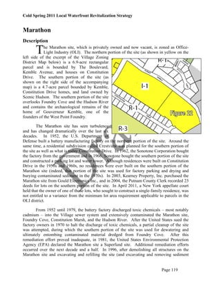
  • 1. Cold Spring 2011 Local Waterfront Revitalization Strategy Marathon Description T he Marathon site, which is privately owned and now vacant, is zoned as Office- Light Industry (OLI). The northern portion of the site (as shown in yellow on the left side of the excerpt of the Village Zoning District Map below) is a 6.9-acre rectangular parcel and is bounded by The Boulevard, Kemble Avenue, and houses on Constitution Drive. The southern portion of the site (as shown on the right side of the accompanying map) is a 4.7-acre parcel bounded by Kemble, Constitution Drive homes, and land owned by Scenic Hudson. The southern portion of the site overlooks Foundry Cove and the Hudson River and contains the archaeological remains of the home of Gouverneur Kemble, one of the founders of the West Point Foundry. The Marathon site has seen turbulence and has changed dramatically over the last six decades. In 1952, the U.S. Department of Defense built a battery manufacturing factory on the northern portion of the site. Around the same time, a residential subdivision called Crestview was planned for the southern portion of the site as well as what is today Constitution Drive. In 1962, the Sonotone Corporation bought the factory from the government and in 1966, Sonotone bought the southern portion of the site and constructed a parking lot and water tower. Although residences were built on Constitution Drive in the 1950s and 1960s, no residences were ever built on the southern portion of the Marathon site (indeed, that portion of the site was used for factory parking and drying and burying contaminated sediment in the 1970s). In 2003, Kearney Property, Inc. purchased the Marathon site from Gould Electronics Inc., and in 2004, the Putnam County Clerk recorded 23 deeds for lots on the southern portion of the site. In April 2011, a New York appellate court held that the owner of one of those lots, who sought to construct a single-family residence, was not entitled to a variance from the minimum lot area requirement applicable to parcels in the OLI district. From 1952 until 1979, the battery factory discharged toxic chemicals – most notably cadmium – into the Village sewer system and extensively contaminated the Marathon site, Foundry Cove, Constitution Marsh, and the Hudson River. After the United States sued the factory owners in 1970 to halt the discharge of toxic chemicals, a partial cleanup of the site was attempted, during which the southern portion of the site was used for dewatering and ultimately entombing contaminated material dredged from Foundry Cove. After this remediation effort proved inadequate, in 1981, the United States Environmental Protection Agency (EPA) declared the Marathon site a Superfund site. Additional remediation efforts occurred over the next decade and a half. In 1996, after demolishing all structures on the Marathon site and excavating and refilling the site (and excavating and removing sediment Page 119
  • 2. Cold Spring 2011 Local Waterfront Revitalization Strategy from most of Foundry Cove and the area near the Cold Spring pier), the EPA completed its Superfund remediation. Deed restrictions imposed by the EPA on the site prohibit groundwater wells anywhere on the site and excavation deeper than 15 feet within the pedestal area (where a cadmium nitrate tank had leaked into the soil), which, as shown on the map at right, is on the eastern edge of the site adjacent to Kemble Avenue. The EPA continues to test soils and monitors the area to track contamination levels. In particular, a groundwater plume of volatile organic compounds (which are probable carcinogens, according to the EPA) currently exists under the Marathon site, radiating from the location of an old solvent shed. Several attempts at remediation of the plume have failed.5 In June 2008, the EPA’s Third Five-Year Review Report on the Marathon Battery Site raised concerns about vapor intrusion at adjacent residential properties and the delineation of the groundwater plume. In July 2011, the EPA issued an Addendum to the 2008 Report that contained a map of the plume showing that it underlies much of the northern portion of the Marathon site as well as residences along Constitution Avenue. Testing wells and an indoor air mitigation system have been installed in and around one of those homes. In the Addendum, the EPA concluded that “[c]urrently, there are no exposure pathways that could result in unacceptable risks.” Nevertheless, the EPA announced that it would launch a pilot program to remediate the groundwater plume by using an air sparging technique, designed to force the volatile organic compounds from the soil through filters and reduce their concentration to an acceptable level.6 The southern portion of the Marathon site is bounded by Kemble Ridge (depicted at right), which overlooks a popular walking trail that connects the West Point Foundry Preserve to the Cold Spring Metro- North station and Foundry 5 The EPA’s Superfund Site Progress Profile for Marathon Battery, available at http://cfpub.epa.gov/supercpad/cursites/csitinfo.cfm?id=0201491, provides a great deal of information about the site and contains links to numerous documents, including Records of Decision and Five-Year Reviews. 6 According to the EPA, the levels of Trichloroethylene (TCE) in the plume range from 14 parts per billion (ppb) at the periphery to 140 ppb at the footprint of the old solvent shed. Although the groundwater at Marathon is not (and cannot be) used for drinking water, in order to address vapor intrusion issues, the EPA will seek to reduce concentrations of TCE to the federal drinking water standard, which is 5 ppb. Page 120
  • 3. Cold Spring 2011 Local Waterfront Revitalization Strategy Cove and includes archeological remains of the home of Gouverneur Kemble, founder of the West Point Foundry. Additionally, Kemble Ridge is visible from the Hudson River, Foundry Cove, Constitution Marsh, Constitution Island, and the Foundry Trail. Many residents and visitors enjoy the natural features of Kemble Ridge and consider its protection to be of vital importance. Indeed, Cold Spring lies within a designated New York Scenic Area of Statewide Significance (SASS),7 and one of the key features of the Cold Spring SASS is Kemble Ridge. The SASS regulations state that “whether within or outside a designated SASS all proposed actions subject to review under federal and State coastal acts or a Local Waterfront Revitalization Program must be assessed to determine whether the action could affect a scenic resource and whether the action would be likely to impair the scenic beauty of the scenic resource.”8 The SASS policy guidelines also provide that structures and other development should be sited back from shorelines or in other inconspicuous locations to maintain the attractive quality of the shoreline. The comments to the SASS guidelines note that: For much of the length of the Hudson Highlands SASS, the Hudson River is bounded by steep, undeveloped wooded bluffs that figure prominently in views within the SASS, notably from and across the Hudson River. Siting of structures on the slopes or crests of these bluffs, on the immediate shoreline of the Hudson River or over the water surface of the Hudson River would introduce discordant elements into the landscape and impair the scenic quality of the SASS. The siting of new residential development has the potential to threaten the future visual quality of the SASS. Areas which afford views, such as ridgelines, hilltops, and hillsides overlooking the Hudson River, are most attractive to new development, but also the most vulnerable to impairment from inappropriate development. The siting of residential development, structures and other discordant features such as large buildings, highways, power lines and signs on ridgelines, hilltops and exposed hillsides and in the direct viewshed of the Hudson River would introduce discordant elements into the landscape and impair the scenic quality of the SASS.9 To the south of the Marathon site lies the 87-acre West Point Foundry Preserve, which is owned by Scenic Hudson and was recently recognized as a site of national significance through its second listing on the National Register of Historic Places. The Cold Spring Planning Board recently held a public hearing on Scenic Hudson’s plan for public access and interpretation of the Foundry Preserve, which will likely increase the amount of vehicular traffic in the area around the Marathon site. To the west of the Marathon site (on the other side of Constitution Drive) lies the 14-acre Campbell Area, which joins the foundry site on the National Register as part of the West Point Foundry Archaeological Site and is also owned by Scenic Hudson. The Campbell Area is currently zoned as Multifamily Residence and consists 7 The Cold Spring subunit of the Hudson Highlands SASS consists of “the Villages of Cold Spring and Nelsonville, located on the east bank of the Hudson River. The southern and eastern boundary of the subunit runs along the 20 foot contour from the northern extent of Foundry Cove to its intersection with Foundry Brook, a common boundary with the Constitution Marsh subunit.” See http://nyswaterfronts.com/SASS/SASS1/Hudson_Highlands.htm#HH- 25%20%20Cold%20Spring%20Subunit. 8 See http://nyswaterfronts.com/SASS/SASS1/Hudson_Highlands.htm#Hudson%20Highlands%20S ubunits. 9 See id. Page 121
  • 4. Cold Spring 2011 Local Waterfront Revitalization Strategy mostly of open space, but contains the 19th-Century home of William Kemble, brother of Gouverneur Kemble and a co-founder of the West Point Foundry. Across the street from the Marathon site on the eastern side of Kemble Avenue are, from north to south, the Veterans of Foreign Wars (VFW) building (which is used regularly by the Town of Philipstown and occasionally by the Village of Cold Spring), several steep, vacant lots, a residence, and the lower portion of a parcel owned by the Village and currently used for collecting brush. It is important that the Village plan for the Marathon site, the Foundry Preserve and the Campbell Area together so as to address potential crowding and traffic issues, because development in one area affects the others, and due to the fact that these areas are the last large tracts of open space in the Village. As shown on the map below, access to the Marathon site is limited and difficult because the roads to Marathon are narrow with mostly single-family residences on either side. One of them, Wall Street, features a sharp turn on a steep hill, which trucks cannot navigate. Another, Kemble Avenue, was a narrow two-way street until it was converted to one-way from Rock Street to Main Street in approximately 2002. As a one- way street, Kemble Avenue now provides convenient and highly valued parking for residents living on that street, and may enhance safety, but it does restrict access. Rock Street is narrow and one-way, with residences close to the street. A private road winds through the Forge Gate complex with two-way traffic limited to residents of the development. The first draft of the Comprehensive Plan, presented to the public in September 2010, drew fire from residents of Forge Gate and Constitution Drive and others for a proposal to link the two-way Lunn Terrace with the western end of The Boulevard. This would have run close to, and possibly be part of, a potential parking facility east of the Metro-North station. Village residents petitioned against the idea, and it was removed from the draft Comprehensive Plan recommended by the Special Board to the Village Trustees in December 2010. Another alternative access route that has been explored and rejected is what is known as the Haul Road. This route is a steep, narrow, winding road within the Foundry Preserve linking Chestnut Street with Kemble that was used for a time by the Superfund contractors for moving heavy equipment (although with limited success). As part of its planned development of the Foundry Preserve, Scenic Hudson proposed that the Haul Road be used for weekend access, as a one- way road leading to parking to be located at the south end of Kemble. Scenic Hudson withdrew the proposal because of local opposition and concerns about the steep grade and the Page 122
  • 5. Cold Spring 2011 Local Waterfront Revitalization Strategy high cost of making the route safe for vehicles. A few other possible access routes, including a link from Benedict to Kemble, and a link from Chestnut to Kemble, have been suggested. Public Input Community input regarding the Marathon site – which led directly to the recommended principles for future development set forth below – is reflected in the following:  2007 Resident Survey  2007 Community Update and Public Forum (October 20, 2007)  2008 Stakeholder Meeting organized by the Waterfront and Open Space Working Group of the Special Board (September 11, 2008)  2009 Waterfront and Open Space Committee Working Group Report (August 2009)  2009 Special Board presentation to Village Board regarding Marathon and Foundry Ridge (September 8, 2009)  2010 Forum on the Marathon Battery Site, West Point Foundry Preserve, and Campbell Property (May 8, 2010)  2010 Community Forum on Marathon, Foundry Preserve and Campbell Property (May 22, 2010)  Public comments regarding the September 2010 Draft of the Comprehensive Plan  2011 Community Forum on Marathon, Dockside and Village Garage (May 14, 2011)  2011 Special Board Meeting focused on the Marathon site (May 26, 2011). Summaries of each of these sources of input are available on the Village website at http://www.coldspringny.gov/Pages/ColdSpringNY_BComm/lwrp. Page 123
  • 6. Cold Spring 2011 Local Waterfront Revitalization Strategy Alternatives In the Office-Light Industrial (OLI) District in which the Marathon site is located, the following uses are currently permitted: office buildings, light industrial uses,10 storage uses, municipal buildings, buildings for the sale of agricultural and nursery products, storage, and one-family residences. The minimum lot size in the OLI District (including residences) is 40,000 square feet per lot, which is about .91 acre.11 In the survey of Village residents conducted in 2007 (see summary chart at left), in response to the question of what uses should be considered for the Marathon site, 45% of respondents said parking, 17% said active recreation (such as a swimming pool, skate park, skating rink, track and ball fields), 14% said open space (either keep the site as is or have passive uses such as a wildflower meadow or gardens), 8% said housing, 3% said community center (such as seniors, teens, pool, or a gym), and 13% specified another use (such as a dog run, conference center, green center, shopping). Although in the survey and in the October 2007 public forum many residents identified public parking as a desired use for the Marathon site, in forums held in May 2010 and May 2011, there was much less support for creating parking areas at Marathon that are not secondary to uses at the site. At these latter forums, while there was support for a mix of limited residential development and some commercial development, many residents expressed strong concerns that development would cause increased traffic and disruption to the area. Also at these latter forums, residents strongly expressed their desire that development at Marathon be consistent with the Village character and reflect the historical nature of the site and the Village. Generally, residents living close to the Marathon site prefer that no development be permitted, or that the current industrial zoning remain, to limit residences to no more than one house per acre. Some Village residents have expressed support for light industrial and 10 These uses may include “manufacturing, assembling, which operation, in the opinion of the Planning Board, will not create any dangerous, injurious, noxious or otherwise objectionable fire, explosive, radioactive or other hazard, noise or vibration, smoke, dust, odor or other form of air pollution, electromagnetic or other disturbance, glare, harmful discharge, storage or dispersal of liquid or solid wastes in a manner or amount as to adversely affect the surrounding area.” Cold Spring Zoning Law § 134-12(B)(7). All buildings and uses proposed for the OLI District require site plan review by the Planning Board. Cold Spring Zoning Law § 134-12(A). 11 See Cold Spring Zoning Law § 134-12(D)(1). Page 124
  • 7. Cold Spring 2011 Local Waterfront Revitalization Strategy commercial development, along with live/work uses, perhaps reflecting the manufacturing past. Local residents have also expressed serious concerns about contamination related to the battery factory. There is strong opposition to relocating the village garage to the Marathon property, even on land where contamination is still an issue, due the proximity of existing residences. Community residents have expressed strong support for protecting Kemble Ridge and opposition to building houses on the ridge. Over the last several years, the current owner of the Marathon site has presented a series of conceptual drawings to the Village Board and the Special Board. 12 It is important to emphasize that, while these drawings may resemble blueprints, they are not actual plans and were presented only for discussion purposes. Also, implementation of the concepts embodied in these drawings would likely require rezoning of the Marathon site, extensive further study, and Planning Board approval. The drawings depict either only residential development, only commercial development, or a mix of residential and commercial development:  In terms of residential development, some of the drawings presented by the current owner of the Marathon site to the Village Board in 2009 show residential lots on the southern portion of the site extending to and covering Kemble Ridge, with between 14 and 23 residential lots ranging in size from 14-.44 acre. Other drawings show, for the northern portion of the site, between 22 and 38 townhouses, two single family lots of .5 acre each, a 2.1 acre lot for future development, an 89-space parking lot and 3.1 acres to be dedicated to the Village (including a stormwater and infrastructure reservation area).  In terms of commercial development, a drawing for the northern portion of the site presented by the current owner of the Marathon site to the Village Board in 2009 shows an industrial park that includes two two-story buildings with basements providing office, manufacturing and warehouse facilities comprising a total of 28,500 square feet of space, four one-story storage buildings comprising a total of 18,750 square feet with additional exterior storage space, a vacant lot of 2.05 acres for “future development,” and a building materials, sales and storage structure containing 16,050 square feet. Each building has its own parking area.  In terms of mixed-used development, the current owner of the Marathon site presented drawings to the Special Board in May 2011 showing an acre-sized park in the northeast corner, between 18 and 21 single-family residences along the western and southern edges of the entire site, between 16 and 24 live-work spaces arranged in three rows of eight each running east to west between the southern single-family residences and a large parking lot, and large commercial/industrial buildings to the north of the parking lot and to the south of the park. The commercial/industrial buildings could be occupied by craftsmen and artisans. The drawings also show a roadway going from the Boulevard at the northwest corner of the site to Kemble Avenue at the south east corner of the site. Community residents expressed some support for these concepts, but also 12 These drawings are available on the Village website at http://www.coldspringny.gov/pages/ColdSpringNY_BComm/2011_community_workshops/20 11_community_workshops. Page 125
  • 8. Cold Spring 2011 Local Waterfront Revitalization Strategy voiced serious concerns about crowding and traffic impacts. The current owner of the Marathon site stated at the May 26, 2011 Special Board meeting that current zoning would allow a 95,000 square foot footprint on the southern portion of the site, which could comprise approximately 250,000 square feet of self-storage space. He added that the Marathon site as a whole could contain approximately 300,000 square feet of storage, but it is unclear whether the market could support such an amount of storage. He also said that he does not wish to build single-family houses on one-acre lots, which would be permitted under current zoning. At the May 2011 public forum on Marathon (which preceded the presentation by the current owner of the Marathon site to the Special Board later that month), the Special Board presented for discussion purposes a conceptual rendering it had commissioned that showed a acre-sized park in the northeast corner of the site, a large parking lot, five large commercial structures abutting the park, 12 single-family homes (including several near the ridge with a narrow conservation easement), a potential site for the Village garage, and five lots left open in the plume area. Although some forum attendees supported the concept of limited commercial and residential development, others were opposed to any development, and most attendees were strongly opposed to development on Kemble Ridge and to relocation of the Village Garage to Marathon. In June 2011, Village resident Peter Henderson submitted a conceptual drawing to the Special Board that included two single-acre light industrial/commercial lots at the northern end of the property and ten single-family lots, each 7500 square feet, either all on Kemble in a row or on a loop road towards the southern end of property. In Mr. Henderson’s drawing, Kemble Ridge was left as open space. Also in June 2011, Village resident James Hartford submitted a conceptual drawing to the Special Board showing the Village Garage maintenance building on the parcel of Village property at eastern side of the southern end of Kemble Avenue adjacent to the Foundry, with a small park on top of the ridge at the end of Benedict Road and stairs leading to/from Benedict Road and Kemble Avenue. In addition to the opposition from local residents to relocating Village Garage functions to a residential neighborhood, it is unclear whether the Village- owned parcel could accommodate the functions and the vehicles that would need to access the site. Page 126
  • 9. Cold Spring 2011 Local Waterfront Revitalization Strategy Recommended Principles for Future Development The following principles – based on public comments received over the last four years and sound planning practice – should guide land use decisions at Marathon, and should provide a framework for a comprehensive, rather than a piecemeal, approach: • Development should not cause congestion or overcrowding. One of the most commonly expressed concerns about future development at Marathon is that it will create traffic problems that diminish the quality of life of current residents of the area (which includes Forge Gate, Constitution Drive, Rock Street, Kemble Avenue, and The Boulevard), many of whom have small children. Additionally, residents have expressed concerns that during any construction, trucks may create a nuisance. Accordingly, prior to any development, an independent traffic study with quantitative and qualitative elements should be performed to assess the impact of the planned development. An independent traffic study should also be performed to investigate alternative access routes to the area, and should address issues related to car, truck, pedestrian and bicycle access, as well as parking. The Village should also review performance standards to minimize traffic and noise disturbance, noxious fumes, and other nuisances, including limiting truck access by route, size and time. Measures that would promote walkability – such as adding sidewalks and creating attractive streetscapes with buildings close to the street – should be encouraged and explored. Mitigation measures to reduce the number of cars entering and exiting the Marathon site could also include limiting the number of residential units, or constructing residential units that would have occupants who would be less likely to rely heavily on cars, such as live-work or work-live units.13 • Development should be tax-positive. Many Village residents have expressed concerns that large-scale residential development at Marathon would increase the financial burden on the Haldane School District and the Village, resulting in increased property taxes. To address these concerns, the Village can employ a widely used planning tool known as fiscal impact analysis to evaluate the tax impact of new development by comparing costs and revenues from new development. Fiscal impact analysis recognizes that businesses and residences generate additional revenue but also create new costs via new roads, sewers, police and fire protection, and more children in schools (requiring teachers and even new school buildings). If new revenues exceed new costs, the fiscal impact is said to be positive. On the other hand, if new costs exceed new revenues, the local government must raise taxes to meet new service demands or reduce the quantity or quality of existing services. Studies have shown that commercial development is generally tax positive, while residential development is generally tax negative.14 To ensure that development at Marathon is tax positive, any 13 In general, work activities in live/work units are those that are compatible with residential occupancies, such as offices, but not manufacturing, whereas work activities in work/live units are the dominant pursuit of the occupants, and may include moderate and low-hazard assembly, fabricating, manufacturing, repair or processing. 14 According to available data, residences in Philipstown cost the municipality approximately $1.20 for every tax dollar generated, while commercial development costs the municipality 30 Page 127
  • 10. Cold Spring 2011 Local Waterfront Revitalization Strategy application for development at this site should be accompanied by a fiscal impact analysis (perhaps as part of the State Environmental Quality Review (SEQR) process) to ascertain the potential fiscal impacts associated with all increased service demands generated by development. Using generally accepted methodology, the fiscal impact analysis would measure the cost and revenue implications of the project for the Cold Spring, Philipstown, and Haldane taxing districts. The analysis should include a no- action alternative to the proposal and should explore mitigation measures that minimize any adverse fiscal impact, both immediate and long-term, of the development. The analysis should also consider the form of ownership for proposed residential units at Marathon (fee simple or condominium ownership) and evaluate the impacts resulting from the potential unequal tax burden on fee simple owners created by condominium ownership, and fee simple ownership for all proposed residential units should be considered as a mitigation measure. The current owner of the Marathon site has stated that the conceptual plans he presented in May 2011, embodying a “village with the village,” would balance residential and commercial uses to generate positive rateables, and would also improve property values in the surrounding areas. Another important aspect of the fiscal impact analysis would be to evaluate the impact of development on infrastructure, including water and sewerage, to ensure that development will not exceed the Village’s carrying capacity. The current owner of the Marathon site has stated that the Village sewer system in the Marathon area (built in the 1970s) has the capacity to handle the conceptual plans he presented in May 2011, but this would need to be confirmed. • Development should provide for a mix of uses. Although some residents have stated that they do not want to see anything built on Marathon, others have said that they want controlled and reasonable development that would promote the economic health of the Village while retaining Village character and minimizing the tax burden. The latter group, as well as the current owner of the Marathon site, support a mix of uses that could include commercial, residential and public open space. As shown in the photograph at right, many buildings on Main Street currently have a mixed- use character, with commercial space on the ground floor and residences on upper floors. Each of the potential uses for Marathon will be discussed in turn:  Residential units. Although many residents have expressed concerns about residential development, there has been support for live-work units, which have cents for every tax dollar it generates, and open space generates about 20 cents on the dollar. See “Pointers for Economic Development,” created in 2002 for the Philipstown Comprehensive Plan Special Board by consultant Phillips Preiss Shapiro, at page 33, available at http://philipstown.com/shapiroReport.pdf. Page 128
  • 11. Cold Spring 2011 Local Waterfront Revitalization Strategy been defined as “a single unit (e.g., studio, loft, or one bedroom) consisting of both a commercial/office and a residential component that is occupied by the same resident.”15 Live-work units encourage less reliance on cars, and may be more suitable for adults without children, resulting in a tax-positive outcome. Live/work unit regulations can carry numerous restrictions, for example that “the live/work unit shall be the primary dwelling of the occupant,” that “the residential and the commercial space must be occupied by the same tenant, and no portion of the live/work unit may be rented or sold separately,” and that “the commercial use shall not generate vehicular traffic, in excess of normal residential traffic, which will interfere with residential traffic circulation or shall not cause more than three vehicles including vehicles used by customers, vendors, or delivery services to visit the premises per day.”16 Residents have expressed support for live/work units as potentially conducive to artists and artisans and home occupations. Some residents have suggested that more people working at home would increase the number of people in the Village during the day, which could increase the amount of money residents spend in the Village and reduce the use of cars. It could also contribute to a safer neighborhood as people working at home keep an eye on the street. The current owner of the Marathon site has stated that the conceptual plans he presented in May 2011 embody more of an urban concept than a suburban concept, which is in keeping with the village character, and that live-work spaces (with the second floor as a loft) would be more suitable for adults than for families, and that he does not believe that single-family homes on one-acre lots are consistent with the village character. Also, because Village residents have expressed a desire to have more senior housing in the Village, it would be advisable to explore the possibility of including in any residential development at Marathon some accessible units.  Commercial development. There has also been some support for commercial development, to encourage small businesses that would be tax positive, could provide jobs to Village residents, and would have low impact on the community in terms of traffic and noise. In particular, there has been support for the possibility of attracting scalable technology, research, design, communications, “clean” light industrial, or “green” companies that could employ Village residents, so long they are low-profile. Such companies could be engaged in pursuits as varied as jewelry- making, glassblowing, or the manufacture of medical devices such as prosthetics. Although there appears to be demand for non-retail commercial space within the Village, there is not much support (or apparent demand) for additional retail space, although craft/repair shops could have an ancillary retail component. Many residents have expressed the view that non-retail commercial space should complement Main Street, not compete with it, and provide opportunities for Village/local entrepreneurs and workers. The current owner of the Marathon site has stated that he would consider commercial development that could attract artisans. 15 See Sunnyvale Municipal Code, Section 19.26.230 (“Live/work units”), available at http://qcode.us/codes/sunnyvale/. 16 See id. Page 129
  • 12. Cold Spring 2011 Local Waterfront Revitalization Strategy  Public open space. Many residents strongly support the reservation of a portion of the Marathon site as public open space. Indeed, the drawings commissioned by the Special Board and the drawings presented by the current owner of the Marathon site in May 2011 include a small park at the northeast corner of the site, as a “gateway” or Village green. Although some residents have advocated other community amenities, such as a theater, galleries, a community pool, playing fields, and dog run, concerns have been raised about the impact of these uses on neighboring residences in terms of traffic and noise. • Development should preserve the scenic viewshed of Kemble Ridge. Village residents overwhelmingly support protecting views of Kemble Ridge, which is identified as a contributing feature of the Cold Spring Scenic Area of Statewide Significance (SASS). Local enforcement of the SASS policies during Planning Board review of any development proposed in this area is critical. Also of great concern is the protection of the archaeological resources on the Marathon site, and an archaeological survey should be required during the SEQR review of any application for development proposed in this area. One significant planning technique that could be used to conserve scenic and archaeological resources while allowing for development is conservation subdivision, which employs a four-step design process to identify unbuildable lands and special features of the site around which development is designed, and where a minimum amount of protected open space is required. In this case, the ridgeline and archaeological sites could be identified as areas to preserve, and the open space lands could be placed under a conservation easement to permanently protect them. The current owner of the Marathon site has stated that he is willing to work with Scenic Hudson, which might hold the conservation easement, regarding protection of Kemble Ridge. • Development should proceed only after the satisfactory remediation of environmental contamination. Residents are quite concerned about issues related to the VOC plume on existing residences, and the impact of the plume on potential residents or occupants of the site. In July 2011, the EPA announced a pilot program to remediate the VOCs using air sparging and soil vapor extraction and issued an addendum to the Third Five- Year Review Report on the Marathon Battery site. The EPA expects the pilot program to begin before the end of 2011, although it is not known when the program will be complete. After the EPA-directed remediation project is completed, a thorough study and remediation of contaminants at the site should be performed to assess future risks before development begins. Future occupants of the Marathon site should be made aware of the past contamination issues, and structures should contain active indoor air mitigation systems. • Development should be green. Many Village residents are quite concerned about protecting the natural environment and would like to see greater use of green building and landscaping techniques in the Village. The Marathon Page 130
  • 13. Cold Spring 2011 Local Waterfront Revitalization Strategy site could serve as a model for state-of-the-art energy-efficient design elements, uses of alternative energy sources such as solar and geothermal, and innovative landscaping techniques to control stormwater. The Marathon site is downhill from a large imperviously surfaced area at the Village’s commercial plaza, which causes serious stormwater issues after heavy rains. To control stormwater, development at Marathon should utilize green infrastructure techniques as indicated in the New York State Stormwater Management Design Manual (2010): green roofs (as shown in the photo at right of the Chancery Building at the Chapel of Our Lady Restoration), reducing impervious surfaces, using soil and vegetation within a shallow depression to manage and treat small volumes of rainwater, bioretention areas, vegetated swales, porous pavement, and rain barrels or cisterns. New development should also meet ENERGY STAR, LEED (Leadership in Energy and Environmental Design) or other similar standards. Additionally, new development should use low-wattage, fully shielded lighting to improve energy conservation, visibility and public safety, while minimizing light pollution. The current owner of the Marathon site has stated that he is interested in obtaining LEED certification for structures at Marathon and that rain gardens could be used to manage stormwater at the site. • Development should employ design elements consistent with the village character. Residents have expressed their desire that buildings constructed at the Marathon site, which is located within the Local Historic District, be consistent with the historical character of the Village, as depicted in the photograph at right of a Main Street entryway. Site layout should give prominence to pedestrians, rather than being oriented towards the automobile, with buildings located close to the street and to each other, and parking located behind buildings. Design standards should be adopted to ensure that new development in this area incorporates the features of traditional village neighborhoods. The current owner of the Marathon site has stated that, in view of the Village’s industrial past, he would explore the idea of an industrial “look” to development at Marathon. • Development should maximize Kemble Avenue south of the Boulevard as a pathway. Residents have expressed their desire to preserve the “small-town” streetscape of Kemble Avenue, and to create an attractive walking and bicycle path from Main Street down to the Foundry Preserve, with places to stop and sit. Such a path, which would include sidewalks and shade trees (as shown in the photo of Main Street above) and possibly benches, could tie together Main Street and the Foundry and would remind people of the industrial heritage of the Village. Additionally, if the lots on the eastern side of Kemble are developed (or, in the case of the VFW building, redeveloped), both sides of Kemble should have similar characteristics, in terms of setbacks and building height. Page 131
  • 14. Cold Spring 2011 Local Waterfront Revitalization Strategy • Parking should be secondary to main uses and hidden from streets. Many residents wish to avoid the unsightliness and pollution of parking lots by ensuring that parking areas are not visible from streets. Generally, only sufficient parking that is necessary for future uses should be created, and such areas should be hidden from view (as shown in the photo at right of the parking area behind the waterfront condominiums) and have pervious surfaces. Although in the past some Village residents have considered a parking lot as a desirable use for a portion of the Marathon site, the site has been rejected by Metro-North as a feasible location for commuter parking (because it is too far from the train station and such parking would not be visible from the platform) and is not realistic for Main Street parking (because patrons of Main Street businesses would be unlikely to park several blocks away).17 Additionally, a parking study conducted by the Special Board in 2008 concluded that there is ample parking in the Village such that there is no “parking problem” but rather a “convenience problem” on Main Street at peak times such as weekend afternoons (which can be addressed by measures such as charging for on- street parking rather than building more parking lots). Moreover, building a parking lot at Marathon could create more traffic in the surrounding area, a situation that many residents wish to avoid. Notwithstanding these issues, a small winter parking area could be set aside to replace the current winter parking strip along Kemble. The current owner of the Marathon site has stated that he is in favor of siting parking areas behind buildings. Photos: Page 120 view of Kemble Ridge from Foundry Cove; Page 128, shops on Main Street; Page 130, green-roofed Chancery Building, new annex to Cold Spring’s Chapel Restoration; Page 131, Main Street entryway; Page 132, cars parked behind the Cold Spring Landing condominiums. 17 The planning firm Phillips Preiss & Shapiro has expressed strong skepticism that parking at Marathon could alleviate the perceived parking problem in Cold Spring: Remote parking (at, for instance, the Marathon Battery site) is a mirage. Remote parking is most successful in places like Disneyland where there is a compelling reason to forego the convenience of the car. Instead, merchants should be induced to park on the periphery of downtown. With two employees per store, and since they arrive before shoppers, Main Street merchants otherwise preempt something like 60 of the most convenient parking spaces. Parking space regulations should be carefully calibrated mindful of the need to assure parking turnover, yet allow long enough parking for browsing and dining. This would argue for something like three-hour parking. “Pointers for Economic Development,” at p. 37, available at http://philipstown.com/shapiroReport.pdf. Page 132