ECO - Earth Control for Location Analytics
•
0 likes•36 views

Italian local governments use ECO, an open Territorial Information System, to detect illegal building construction by comparing satellite maps to public records. ECO integrates data from various databases and devices to create a unified Municipal Building Registry. It correlates geospatial and IoT data on buildings, utilities, and sensors to enable applications like public lighting optimization, traffic monitoring, and pollution analysis. ECO customizes maps with user-added layers and APIs to integrate with other systems according to users' needs.

Recommended
Recommended
More Related Content
What's hot
What's hot (20)
Similar to ECO - Earth Control for Location Analytics
Similar to ECO - Earth Control for Location Analytics (20)
Recently uploaded
Recently uploaded (20)
ECO - Earth Control for Location Analytics
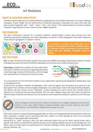
- 1. www.sadasdb.com IoT Solutions WHAT IS LOCATION ANALYTICS? THE PROBLEM THE SOLUTION Transforming the huge amount of data collected by organizations into valuable information is a major challenge nowadays. To gain insight into the performance of business processes, enterprises can query their data and have answers regarding “who”, “what”, “when”, “how”, and “where”. The implementation of Location Analytics empowers organizations to have answers to their “where” questions. The data components required for a Location Analytics implementation include data coming from both traditional operational databases and other databases, as well as in GISs (Geographic Information Systems). These data are geographic or spatial in nature. ECO: an open Territorial Information System that works with SADAS technology. Sadas Engine allows to analyze heterogeneous data coming from different databases and devices and to neatly visualize them. Sadas Engine enables the correlation of many information coming from different sources by integrating data bases containing huge volumes of information, and to manage very big quantities of historical and real-time data. ECO is also made for representing data geographically on maps, as the geographical representation of data can often constitute a simpler way of visualizing data than reports. It is then possible to move from structured information to data graphically represented. Having ECO an “open” structure, users can add customized layers that can be either directly drawn with a specific web-editor or imported from external sources, all by keeping satellite pictures on the background. This allows users to create layers of anything that is of interest: buildings, forests, plants installation, geo-location devices, pollution, etc… It is necessary to correlate data coming from a lot of different and heterogeneous sources, including devices, (i.e. Internet of Things), and process it in order to obtain orderly data and, ultimately, information about the territory. It is a key element for the Information System of any organization operating with geographic-related data, such as local government. Italian local governments use ECO to detect the construction of illegal buildings and prevent this practice. In this case, Sadas Engine compared satellite maps to those owned by the public administration, and identified misalignments between the two. It permits the correlation between all databases, both internal (registry and tax-related) and external to the local government (utilities and land register databases), thus allowing to create a Municipal Building Registry. The system will then contain all the “attributes” of each building unit, and it will be the constant point of reference for monitoring and planning activities. ECO can also integrate these data with those coming from different types of devices and sensors, such as presence and temperature detectors, pollution control devices, etc… Data Warehouse
- 2. We provide software and services for data analysis in various and heterogeneous sectors, together with a range of cutting-edge Business Intelligence solutions. SADAS operates in many industries: banking, leasing, government, insurance, media & telco and retail. To know more about our products, visit our website www.sadasdb.com, or email us at info@sadasdb.com MILANO Headquarters Via Boschetti, 1 • 20121, Milano Tel: +39 02 29017449 ROMA Sales Management Via Principessa Clotilde, 7 • 00196, Roma Tel: +39 06 83089713 BATH Consulting & Training Services 1 Priory Close • Bath, BA2 5AL, UK Tel: +44 1225637004 SAN FRANCISCO USA International Office 20 California St. 7th floor • San Francisco, CA, 94111, USA Tel: +1 415 429 3969 NAPOLI Registered Offices, R&D, Customer Service Via Napoli, 159 • 80013, Casalnuovo di Napoli (NA) Tel: +39 081 8427112 / fax: +39 081 8427171 ECO uses all geo-referenced images available of the territory (air and satellite pictures), even if they have different coordinate systems. These images can be taken from both a local server and from the web, such as the maps of Google or Bing. Digitized images are then put on top of raster images, and they work as layers. Users can choose, according to their needs, to visualize both raster images (one or more) and digitized images at the same time, in order to find any misalignment between them. • Public lighting optimization • Traffic monitoring • Street safety • Energy saving • Waste water treatment • Historical data analysis of pollution control devices • etc… HOW CAN ECO DO THAT? For example: Just by mapping every light pole, it is possible to see if the lighting system works correctly according to the rules set and people’s needs. By mapping cities’ points of delivery of electricity, public gas or water, it is possible to detect incorrect or illegal practices. Public lighting with LED system Utilities services ECO is able to interact in many ways with the user: it offers a set of tools that facilitate its customization and adaptation to users’ specific needs. Moreover, ECO has APIs (application programming interfaces) in order to permit the use of its own cartographic functionalities also from other applications. SOME OF ECO’S USES: IoT Solutions