
Recommandé
Contenu connexe
Similaire à handiout.docx
Similaire à handiout.docx (20)
Plus de shucaybcabdi
Plus de shucaybcabdi (20)
Dernier
Dernier (20)
handiout.docx
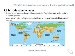
- 1. JPTC, WSS, Sketch and interpret map and drawing handout for level I Prepare by Eng Shuaib Muhumed 1 1.1 introduction to maps • A map is a representation of all or part of the Earth drawn on a flat surface at a specific scale. • Maps use a variety of symbols and colours to represent selected features of an area.
- 2. JPTC, WSS, Sketch and interpret map and drawing handout for level I Prepare by Eng Shuaib Muhumed 2 1.2 Types of maps 1.General purpose maps (reference maps, ) show both natural and human-made features such as coastlines, lakes, rivers, boundaries, settlements, roads, rail lines, and others. 2.Thematic maps, (special-purpose maps, ) illustrate the geographical distribution of a particular theme or phenomenon. Landforms, aspects of climate, vegetation and soil types, demographics, industry, manufacturing, and natural resources are examples of thematic map. 3. Topographic maps As the term suggests, these maps show the topography or surface features of the landscape through the use of contour lines.
- 3. JPTC, WSS, Sketch and interpret map and drawing handout for level I Prepare by Eng Shuaib Muhumed 3 UK annual mean wind speed UK Bedrock Geology Title North Point Scale Key
- 4. JPTC, WSS, Sketch and interpret map and drawing handout for level I Prepare by Eng Shuaib Muhumed 4 The upper left side map is political map for Europe but the lower right-side map is showing physical appearance of Europe continent
- 5. JPTC, WSS, Sketch and interpret map and drawing handout for level I Prepare by Eng Shuaib Muhumed 5 • all maps share common properties or map basics that provide information to assist the reader in studying and interpreting the maps. and they are called map elements as listed below. 1.3 Basic Elements of Maps • a title, • scale, • legend, • date of publication, • direction, • information about the map projection. Etc.
- 6. JPTC, WSS, Sketch and interpret map and drawing handout for level I Prepare by Eng Shuaib Muhumed 6 Direction: Direction tells you which way to hold the map. By convention, most maps are made with their top portion directed at North. The North direction is generally indicated by an arrow in the maps Legend: is a guide which lists symbols and colours used on a map to represent different geographic features. Legend helps to identify what symbols and colours represent in the map. Scale: can be defined as the ratio of the distance between two points on the map and the same two points on the Earth’s surface.
- 7. JPTC, WSS, Sketch and interpret map and drawing handout for level I Prepare by Eng Shuaib Muhumed 7
- 8. JPTC, WSS, Sketch and interpret map and drawing handout for level I Prepare by Eng Shuaib Muhumed 8 1.4Topographic maps. A graphical representation of the three-dimensional shape of the earth’s surface that shows elevation and shape. Contours are lines on a map that join places of equal elevation above the sea level. This three-dimensional effect allows for detailed study of landscape and drainage features. Topographic maps are usually of a large scale and show many of the features of general-purpose maps in considerable detail.
- 9. JPTC, WSS, Sketch and interpret map and drawing handout for level I Prepare by Eng Shuaib Muhumed 9 ________1km N A B
- 10. JPTC, WSS, Sketch and interpret map and drawing handout for level I Prepare by Eng Shuaib Muhumed 10 1.5. Topographic profile topographic profile is a diagram that shows the change in elevation of the land surface along anygiven line (an area “looked from the side”).
- 11. JPTC, WSS, Sketch and interpret map and drawing handout for level I Prepare by Eng Shuaib Muhumed 11 How to Make a Topographic Profile This represents a very simple topographic map of a hill. The hill is steep on the left side (thecontour lines are very close together) and has a gentle slope on the right side. The numbers represent the elevation of the contour lines. (*) What would the hill look like if you were to slice it from left to right? (*)
- 12. JPTC, WSS, Sketch and interpret map and drawing handout for level I Prepare by Eng Shuaib Muhumed 12 This is what the hill would look like if you were to cut italong the profile line and look at it from the side. (*) 200 100 300 400 500 feet 400 feet 300 feet 200 feet 100 et Normally, the Earth’s surface is not this blocky. In a topographic profile a line is drawn from these points (red dots) producing a smooth transition. (*)
- 13. JPTC, WSS, Sketch and interpret map and drawing handout for level I Prepare by Eng Shuaib Muhumed 13 1.6 contour lines Contour line is an imaginary line on the ground surface joining the points of equal elevation is known as contour. It facilitates depiction of the relief of terrain in a two-dimensional plan or map. In other words, contour is a line in which the ground surface is intersected by a level surface obtained by joining points of equal elevation. This line on the map represents a contour and is called contour line. Contouring is the science of representing the verticaldimension of the terrain on a two-dimensional map.
- 14. JPTC, WSS, Sketch and interpret map and drawing handout for level I Prepared by Eng Shuaib Muhumed 14
- 15. JPTC, WSS, Sketch and interpret map and drawing handout for level I Prepared by Eng Shuaib Muhumed 15 1.7 Contour Map • a map showing contour lines is known as Contour map. • A contour map gives an idea of the altitudes of the surface features as well as their relative positions in plan serves the purpose of both, a planand a section.
- 16. JPTC, WSS, Sketch and interpret map and drawing handout for level I Prepared by Eng Shuaib Muhumed 16 1.8Basicelementsofcontourmaps indexContour Line is a bolded Contour lines with elevation numbers above the sea level Contour Interval (CI) – It is the vertical distance between any twoconsecutive contours. This interval depends upon (i) the nature of the ground (i.e. whether flat or sleep). (ii) the scale of the map (iii) the purpose of the survey. Horizontal equivalent (he) Horizontal equivalent is the horizontal distance between two consecutive contour lines measured tothe scale of the map. Gradient - The steepness of a slope as measured in degrees, percentage, or as a distance ratio (rise/run).
- 17. JPTC, WSS, Sketch and interpret map and drawing handout for level I Prepared by Eng Shuaib Muhumed 17 The difference in elevation between the two index contours (800 - 700)is 100. We cross five lines as we go from the 700m line to the 800m line (NOTE:We count the lines between the index contours, then ADDone. In this case, we have 4 lines + 1= 5). Therefore, is we divide the elevation difference (100) by the numberof lines (5) we will get the contour interval. In this case it is 20.
- 18. JPTC, WSS, Sketch and interpret map and drawing handout for level I Prepared by Eng Shuaib Muhumed 18
- 19. JPTC, WSS, Sketch and interpret map and drawing handout for level I Prepared by Eng Shuaib Muhumed 19 10 30 10 30 20 0 100 1400 5 35 200 4400
- 20. JPTC, WSS, Sketch and interpret map and drawing handout for level I Prepared by Eng Shuaib Muhumed 20 20 180 200 1400 5 +25
- 21. JPTC, WSS, Sketch and interpret map and drawing handout for level I Prepared by Eng Shuaib Muhumed 21 1.9 General Features of Contour Line Topographic Maps can show:elevation: Contour lines connect points of equal elevation. Topographic Maps can show: if the land is steep or gentle Steep slopes are shown by closely spaced contour line Gentle slopes are shown by widely spaced contour lines. Contour lines do notintersect, branch or cross.
- 22. JPTC, WSS, Sketch and interpret map and drawing handout for level I Prepared by Eng Shuaib Muhumed 22 Topographic Maps can show whether it is a ridge or a valley, and stream flow directions: A valley on a topographic map is represented by a series of V-shaped contour lines pointing towards higher elevations. When contour lines cross streams they bend in upstream; that means, the contour line forms a 'V or U-shaped' with the apex at the intersection with the stream, and pointing in an upstream direction.
- 23. JPTC, WSS, Sketch and interpret map and drawing handout for level I Prepared by Eng Shuaib Muhumed 23 A ridge on a topographic map is represented by a series of V-shaped contour lines pointing towards lower elevations. Ridge valley 1km
- 24. JPTC, WSS, Sketch and interpret map and drawing handout for level I Prepared by Eng Shuaib Muhumed 24 Topographic Maps can show if there is Hill or Depression Closed contours appearing on the map as ellipses or circles represent hill, Closed contours with hachures, short lines pointing toward the center o fthe closure represent closed depressions. on the other hand, we can identify based on the elevation value for the inner/ outer loops it is a hill if the innermost loop has higher number of elevations. It is depression if the innermost loop has lower value number.
- 25. JPTC, WSS, Sketch and interpret map and drawing handout for level I Prepared by Eng Shuaib Muhumed 25 1.10. Purpose (Uses) Of Contouring/Contour Map Contour survey is carried out at the starting of any engineering projects such as a road, a railway, a canal, a dam, bridges a building etc. contour maps are prepared in order to select the mosteconomical or suitable site. It helps to locate the alignment of a canal so that itshould follow a ridge line. It helps to mark the alignment of roads and railways so that the quantity of earthwork both in cutting and fillingshould be minimum. It helps for getting information about the groundwhether it is flat, undulating or mountainous. It helps to find the capacity of a reservoir and volumeof earthwork especially in a mountainous region. It helps to locate the physical features of the groundsuch as a pond depression, hill, steep or small slopes
- 26. JPTC, WSS, Sketch and interpret map and drawing handout for level I Prepared by Eng Shuaib Muhumed 26