
Recommended
Recommended
More Related Content
Recently uploaded
Recently uploaded (20)
Featured
Featured (20)
AddressStreetPolitical (ASP) Geodatabase (GDB) Schema
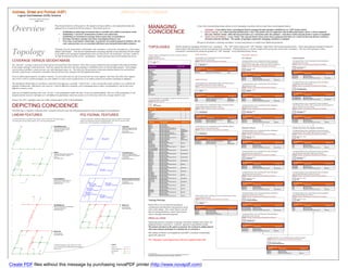
- 1. Address, Street and Political (ASP) Jefferson County, Colorado Logical GeoDatabase (GDB) Schema POST-ESRI CONSULTING DRAFT SHEET 1 OF 8 Overview The principal objective of this project is the migration of legacy address, street and political data and applications to a modernized GIS environment. The primary goals are: MANAGING At least three data modeling design options exist for managing coincidence between same linear and polygonal features: Topologies: Create distinct linear and polygonal datasets managed through topologies established in an “ASP” feature dataset. Establishing an addressing environment that is extensible and scalable to meet future needs, Establishing a “practical” normalization of address and related data, COINCIDENCE Linear Layering: Use a linear layering attribute from a “base” line feature class in conjunction with ancillary point feature classes to derive polygonal data (aka “Sidwell” model). Other line-based derivatives are created from other line attributes. Coincidence of line and poly features requires no topologies. Establishing an environment to manage many-to-many data correspondences, Atomic Line and Polygons: Create “atomic” line and poly feature classes from whence polygonal derivatives are created via base-poly dissolves and linear Ensuring coincidence amongst same linear and polygonal features, and derivatives from line attributes. The number of topologies required for managing coincidence is minimal. Preserving crucial tabular relationships- in particular how political polygonal attributes, like city code, county precinct, etc, are associated with linear street and point-based address features. The goal in all designs is ensuring coincidence: we need same features to contain exact (identical) geometries. TOPOLOGIES The first design for managing coincidence uses “topologies”. The “ASP” feature dataset and “ASP_Topology” table (below left) list participating entities. Linear and polygonal topological categories (below) depict individual feature classes participating in the topologies. Polygonal features are further categorized by group type relative their coincidence. Note that with topologies in place, Topology Topology concerns spatial feature relationships, like coincidence, connectivity, and adjacency, which impact tabular relationships. Note that the implementation of topology depends on the underlying GIS data model. coincidence is maintained by editing the geometry of “ASP_Topology” versus individual feature classes. In the ESRI world, topological implementations have two basic forms: the traditional “coverage” model of POINT TOPOLOGY A feature dataset containing feature classes with point, line and POLYGONAL TOPOLOGY Arc/Info Workstation and the current “geodatabase” model associated with ArcGIS Desktop and Server. polygon topologies. A point feature class containing the set of all point features CITY GROUP CENSUS GROUP SOURCE: Manually implemented. representing street intersections. COVERAGE VERSUS GEODATABASE Feature Dataset SOURCE: “geocode” coverage and processing (to be developed) A polygonal feature class containing the subset of polygons A polygonal feature class containing the subset of polygons representing census tracts. ASP representing city code. Note: These are not legal municipal Feature Class - Point The “geocode” coverage is made up of street and non-street (political) linear features which when closing on themselves form polygons with political attributes. Intersection boundaries but simply define incorporated status for addresses. SOURCE: “geocode” coverage polys and processing (to be developed) Member Name Member Type SOURCE: “geocode” coverage polys and processing (to be developed) In this model, topology is built and stored. Each line segment has direction, and when topology is established, knows its left and right polygons. Each polygon FC Topology Rank 2 Feature Class - Polygon CensusTract Feature Class - Polygon carries political attributes- county precinct, city code (municipal status), etc. This allows for the generation of derivative political datasets for each political ASP_Topology Topology Origin FC Topology Rule Destination FC CityCode BaseLine Line attribute, using dissolve, and ensures coincidence between the base lines, polygons and all polygonal derivatives. BasePoly Polygon Intersection Must Be Covered By Endpoint Of Street FC Topology Rank 5 CensusBlock Polygon FC Topology Rank 5 Origin FC Topology Rule Destination FC CensusBlockGroup Polygon CensusTract Polygon Origin FC Topology Rule Destination FC CensusTract Must Not Overlap From an addressing perspective, an address“matches” (is associated with) one side of one and only-one street segment. Since that side of the street segment CityCode Polygon CityCode Must Not Overlap CensusTract Must Not Have Gaps CityPrecinct Polygon CensusTract Must Be Covered By Feature Class Of CensusBlock also carries a link to a political polygon, two joins (address to street, street to political) give us an address-political association containing no ambiguity. CityWard Polygon LINEAR TOPOLOGY CityCode CityCode Must Not Have Gaps Must Be Covered By Feature Class Of CityPrecinct CommissionerDistrict Polygon CountyPrecinct Polygon FedHouse Polygon A polygonal feature class containing the subset of polygons The topological relationships of coincidence, connectivity and adjacency essentially “come for free” in the coverage data model, making it very useful for the A linear feature class containing the subset of all linear features A polygonal feature class containing the subset of polygons Intersection Point representing census block groups. NonStreetLine Line representing named streets, roads or highways. representing city wards. demands of addressing. Deficiencies exist, however- it may be difficult to normalize, poor at managing many-to-many correspondences, and in some cases, Patrol Polygon SOURCE: “geocode” coverage and processing (to be developed) SOURCE: “geocode” coverage polys and processing (to be developed) RTD Polygon SOURCE: “geocode” coverage polys and processing (to be developed) difficult to extend or scale. SouthJeffCo Polygon Feature Class - Polygon StateHouse Polygon Feature Class - Line Feature Class - Polygon CensusBlockGroup StateSenate Polygon Street CityWard Street Line Only one of 26 defined topology rules come “for free” in the geodatabase model- the other 25 must be explicitly defined. However, if the geodatabase is well TIFA Polygon FC Topology Rank 5 UnnamedRoad Line FC Topology Rank 1 FC Topology Rank 5 Origin FC Topology Rule Destination FC designed and the necessary topologies are well defined, the geodatabase model may greatly excel in the areas where the coverage model is weak. Origin FC Topology Rule Destination FC Origin FC Topology Rule Destination FC CensusBlockGroup Must Not Overlap The ASP topologies for managing coincidence and other point, line Street Must Be Covered By Feature Class Of BaseLine CityWard Must Not Overlap CensusBlockGroup Must Not Have Gaps CensusBlockGroup Must Be Covered By Feature Class Of CensusBlock Feature class (FC) topologies must exist within a feature dataset (FD) in the geodatabase. and polygon feature relationships. Street Street Must Not Overlap With Must Not Overlap With UnnamedRoad NonStreetLine CityWard CityWard Must Not Have Gaps Must Be Covered By Feature Class Of CityPrecinct SOURCE: Manually implemented. A polygonal feature class containing the subset of polygons DEPICTING COINCIDENCE Topology ASP_Topology Feature Class Rank A linear feature class containing the subset of all linear features representing unnamed roads, lanes or drives. SOURCE: “roadrpiv” coverage (or “geocode”, if incorporated) A polygonal feature class containing the subset of polygons representing city precincts. SOURCE: “geocode” coverage polys and processing (to be developed) representing census blocks. (Note: several polys may be required in order to represent one census block). SOURCE: “geocode” coverage polys and processing (to be developed) The following is a simplistic rendering of how coincidence between same line and polygonal features may be managed in the geodatabase. BaseLine 1 Feature Class - Line Feature Class - Polygon Feature Class - Polygon Street 1 UnnamedRoad CityPrecinct CensusBlock UnnamedRoad 1 LINEAR FEATURES POLYGONAL FEATURES Intersection NonStreetLine 2 3 FC Topology Rank 1 FC Topology Rank 5 FC Topology Rank 5 BasePoly 4 Origin FC Topology Rule Destination FC Origin FC Topology Rule Destination FC Origin FC Topology Rule Destination FC All other polygonal FCs 5 A structure that allows individual linear feature classes within the ASP feature dataset A structure that allows individual polygonal feature classes within the ASP feature See rationale (below) for more information in initial rankings. UnnamedRoad Must Be Covered By Feature Class Of BaseLine CityPrecinct Must Not Overlap CensusBlock Must Not Overlap to be built upon one base linear feature class with coincident geometry. dataset to be built upon one base polygonal feature class built on one base linear UnnamedRoad Must Not Overlap With Street CityPrecinct Must Not Have Gaps CensusBlock Must Not Have Gaps feature class where coincidence is maintained for all. Origin FC Topology Rule Destination FC UnnamedRoad Must Not Overlap With NonStreetLine CityPrecinct Must Be Covered By Feature Class Of BasePoly CensusBlock Must Be Covered By Feature Class Of BasePoly BaseLine Must Not Intersect BaseLine Must Not Overlap StreetMaintained CityCode BaseLine Must Not Self-Overlap A linear feature class containing the subset of all linear features subset of all street linear features subset of all polygonal features BaseLine Must Not Overlap or Touch Interior Of representing non-street (political) lines. PRECINCT GROUP OTHER POLITICAL POLYGONAL DATASETS maintained by Jefferson County representing distinct city codes Street Must Be Covered By Feature Class Of BaseLine SOURCE: “geocode” coverage arcs and processing (to be developed) linear feature class (CITYCODE). Street Must Not Overlap With UnnamedRoad A polygonal feature class containing the subset of polygons A polygonal feature class containing the subset of polygons Street Must Not Overlap With NonStreetLine polygonal feature class Intersection Must Be Covered By Endpoint Of Street Feature Class - Line representing federal house districts. representing the TIFA (Traffic Improvement Fee Area) district. UnnamedRoad Must Be Covered By Feature Class Of BaseLine NonStreetLine SOURCE: “geocode” coverage polys and processing (to be developed) SOURCE: “geocode” coverage polys and processing (to be developed) GF 00 14 69 UnnamedRoad Must Not Overlap With Street YO 149 D = 21 8 T UnnamedRoad Must Not Overlap With NonStreetLine DS Feature Class - Polygon Feature Class - Polygon NonStreetLine Must Be Covered By Feature Class Of BaseLine FC Topology Rank 3 IEL FedHouse TIFA 101 AINI 1 CCID = xxxxxxxx CCID = xxxxxxxx NonStreetLine Must Not Overlap With Street Origin FC Topology Rule Destination FC RM CITYCODE = 07 CITYCODE = 01 NonStreetLine Must Not Overlap With UnnamedRoad UN ST BasePoly Must Not Overlap NonStreetLine Must Be Covered By Feature Class Of BaseLine FC Topology Rank 5 FC Topology Rank 5 BasePoly Must Not Have Gaps NonStreetLine Must Not Overlap With Street BasePoly Boundary Must Be Covered By BaseLine Origin FC Topology Rule Destination FC Origin FC Topology Rule Destination FC NonStreetLine Must Not Overlap With UnnamedRoad CountyPrecinct Must Not Overlap FedHouse Must Not Overlap TIFA Must Not Overlap CountyPrecinct Must Not Have Gaps FedHouse Must Not Have Gaps TIFA Must Not Have Gaps CountyPrecinct Must Be Covered By Feature Class Of BasePoly FedHouse Must Be Covered By Feature Class Of CountyPrecinct TIFA Must Be Covered By Feature Class Of BasePoly CommissionerDistrict Must Not Overlap CommissionerDistrict Must Not Have Gaps CommissionerDistrict Must Be Covered By Feature Class Of CountyPrecinct StateHouse Must Not Overlap A polygonal feature class containing the subset of polygons A polygonal feature class containing the subset of polygons Street CountyPrecinct StateHouse Must Not Have Gaps representing state senate districts. representing the South JeffCo Improvement District. subset of all linear features representing StateHouse Must Be Covered By Feature Class Of CountyPrecinct subset of all polygonal features StateSenate Must Not Overlap SOURCE: “geocode” coverage polys and processing (to be developed) SOURCE: “geocode” coverage polys and processing (to be developed) named streets (roads) in Jefferson representing distinct county precincts StateSenate Must Not Have Gaps County. CPID = 5183 (COUNPREC). StateSenate Must Be Covered By Feature Class Of CountyPrecinct Feature Class - Polygon Feature Class - Polygon linear feature class COUNPREC = 2162530005 polygonal feature class FedHouse Must Not Overlap StateSenate SouthJeffCo FedHouse Must Not Have Gaps 8 YO 149 2169 FedHouse Must Be Covered By Feature Class Of CountyPrecinct T GF 00 14 DS CityPrecinct Must Not Overlap FC Topology Rank 5 FC Topology Rank 5 IEL 101 RID = CityPrecinct Must Not Have Gaps 1 CPID = xxxxxxxx CityPrecinct Must Be Covered By Feature Class Of BasePoly Origin FC Topology Rule Destination FC Origin FC Topology Rule Destination FC ST UN COUNPREC = 2162530004 CityWard Must Not Overlap StateSenate Must Not Overlap SouthJeffCo Must Not Overlap CityWard Must Not Have Gaps StateSenate Must Not Have Gaps SouthJeffCo Must Not Have Gaps CityWard Must Be Covered By Feature Class Of CityPrecinct StateSenate Must Be Covered By Feature Class Of CountyPrecinct SouthJeffCo Must Be Covered By Feature Class Of BasePoly CityCode Must Not Overlap CPID = 5187 CityCode Must Not Have Gaps COUNPREC = 2162530006 CityCode Must Be Covered By Feature Class Of CityPrecinct CensusBlock Must Not Overlap A polygonal feature class containing the subset of polygons A polygonal feature class containing the subset of polygons CensusBlock Must Not Have Gaps CensusBlock Must Be Covered By Feature Class Of BasePoly representing state house districts. representing RTD (Ride The Denver) districts. CensusBlockGroup Must Not Overlap SOURCE: “geocode” coverage polys and processing (to be developed) SOURCE: “geocode” coverage polys and processing (to be developed) CensusBlockGroup Must Not Have Gaps CensusBlockGroup Must Be Covered By Feature Class Of CensusBlock Feature Class - Polygon Feature Class - Polygon UnnamedRoad BasePoly (BasePolitical) Census Tract Must Not Overlap StateHouse RTD subset of all linear features that are all polygonal features- a subset of all Census Tract Must Not Have Gaps unnamed lanes, drives or roads. linear features Census Tract Must Be Covered By Feature Class Of CensusBlock BPID = 5183 Patrol Must Not Overlap FC Topology Rank 5 FC Topology Rank 5 linear feature class BPID = 313366 polygonal feature class CITYCODE = 01 Patrol Must Not Have Gaps CITYCODE = 07 Origin FC Topology Rule Destination FC Origin FC Topology Rule Destination FC COUNPREC = 2162530005 Patrol Must Be Covered By Feature Class Of BasePoly COUNPREC = 2162530004 RTD Must Not Overlap StateHouse Must Not Overlap RTD Must Not Overlap RTD Must Not Have Gaps StateHouse Must Not Have Gaps RTD Must Not Have Gaps BPID = 40674 RTD Must Be Covered By Feature Class Of BasePoly StateHouse Must Be Covered By Feature Class Of CountyPrecinct RTD Must Be Covered By Feature Class Of BasePoly CITYCODE = 07 SouthJeffCo Must Not Overlap COUNPREC = 2162530004 SouthJeffCo Must Not Have Gaps BPID = 40677 SouthJeffCo Must Be Covered By Feature Class Of BasePoly CITYCODE = 07 TIFA Must Not Overlap A polygonal feature class containing the subset of polygons A polygonal feature class containing the subset of polygons COUNPREC = 2162530004 TIFA Must Not Have Gaps BPID = 5187 representing commissioner districts. representing Sheriff patrol districts. CITYCODE = 01 TIFA Must Be Covered By Feature Class Of BasePoly A linear feature class containing all street, unnamed road, and non- SOURCE: “geocode” coverage polys and processing (to be developed) SOURCE: “geocode” coverage polys and processing (to be developed) COUNPREC = 2162530006 street (political) linework. SOURCE: “geocode” coverage arcs and processing (to be developed) Feature Class - Polygon Feature Class - Polygon Topology Rankings CommissionerDistrict Patrol Feature Class - Line BaseLine FC Topology Rank 5 FC Topology Rank 5 NonStreetLine BaseLine Ranks (above) are an important topological Origin FC Topology Rule Destination FC Origin FC Topology Rule Destination FC subset of all linear features representing non-street (political) lines. all linear features consideration and determine what geometry moves FC Topology Rank Origin FC 1 Topology Rule Destination FC CommissionerDistrict Must Not Overlap Patrol Must Not Overlap linear feature class CommissionerDistrictt Must Not Have Gaps Patrol Must Not Have Gaps linear feature class where when editing. Here, linear features are the CommissionerDistrictt Must Be Covered By Feature Class Of CountyPrecinct Patrol Must Be Covered By Feature Class Of BasePoly 92 BaseLine Must Not Self Intersect 92 519 basis for polygonal features, hence linear feature BaseLine Must Not Self Overlap 519 =1 BaseLine Must Connect at Endpoints =1 classes outweigh (outrank) polygonal. A polygonal feature class containing the subset of polygons 169 LID BaseLine Must Not Intersect Or Touch Interior D BLI NS =2 representing county precincts. D BLI 7 7 SOURCE: “geocode” coverage polys and processing (to be developed) 134 134 PROS AND CONS =5 =5 Feature Class - Polygon LID D BLI CountyPrecinct NS Employing numerous topologies to manage coincidence amongst many linear and polygonal features represents a “textbook” approach to geodatabase design. FC Topology Rank 5 Or