Student Profile Sample - We help schools to connect the data they have, with ...
Wikimaps Wikimania 2013
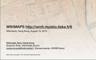
1. WIKIMAPS
Wikimania, Hong Kong, August 10, 2013
Wikimaps Tartu–Hong Kong
Susanna Ånäs, Wikimedia Suomi
susanna.anas@wikimedia.fi, @susannaanas, @WMFinland
Map: Tartu linna plaan, 1914. Estonian National Archives
7. The maps need to be digitized
And georeferenced
Not restricted by copyright
Served through user-friendly interfaces
Referenced from Wikipedia
Used anywhere
Available for annotations
Semantically linked
Returned enriched to memory institutions
Even millions of items should be handled easily
8. Visualizing scenes from history or literature.
Routing with historical restrictions, road networks.
Linking places to their names across time and also to instances of
maps that show them.
Creating historical maps for Wikipedia.
Geotagging historical photographs with the help of the historical
maps from the same era.
Exploration of networked historical topics.
What could the maps be used for?
19. GLAM cooperation
Maps to Commons
Adding geolocation
to maps in Commons
Finding maps on a
map in Wikimedia
Extracting features
from old maps
Spatiotemporal
gazetteer in Wikidata
Data driven maps in
Wikimedia
20. GLAM cooperation
Maps to Commons
•Developing maps collaboration with GLAMs
• Wikimaps Nordic: ~25 GLAMs in the Nordic countries
•Creating a Template:Map
• Jarek Tuszynski, Maarten Dammers
•Applying the map template in the GLAM-wiki toolset
• David Haskiya, Dan Entous / Europeana
21.
22.
23.
24. Adding geolocation
to maps in Commons
•Creating the Wikimaps Warper
• Georeferencing files from the Commons
• Further developing the MapWarper that has been created for the
New York Public Library
• Tim Waters, Tim Alder
25.
26.
27.
28. Finding maps on a
map in Wikimedia
•Using the OSM tileserver that will be hosted by Wikimedia
•Filtering by date, place, topic
29. Extracting features
from old maps
•Collaborating with the OpenStreetMap creating shared resources
• iD editor in Open Historical Map (a project of OpenStreetMap) for
digitizing (tracing) the old maps from the Commons
• Storing geometries in OHM and/or Wikidata
• Jeff Meyer, Mikel Maron et al
30.
31. Spatiotemporal
gazetteer in Wikidata
•Connecting geometries with Wikimedia through Wikidata
•Developing the model for interlinking historical geodata and
knowledge in Wikimedia
• Change events, hierarchies, geometries, time
• Handling uncertainty and imprecision
• Historical geospatial data task force
32. Data driven maps in
Wikimedia
•Developing maps and map data reuse possibilities in Wikimedia
• Using OpenStreetMap as a base for maps
• Further developing the work of the Wikimedia Maps Lab
• Combining geometries and data from Wikimaps / Wikimedia &
external sources
• Hugo Lopez, Arun Ganesh
34. Wikimaps workshop in State of the Map Baltics
August 4, Tartu, Estonia
Wikimaps roundtable in Wikimania
August 7, Hong Kong
Open Historical Map code sprint
August 10 & 11, USA
http://commons.wikimedia.org/wiki/Commons:Wikimaps/Wikimaps_Tartu–Hong_Konghttp://commons.wikimedia.org/wiki/Commons:Wikimaps/Wikimaps_Tartu–Hong_Kong
http://blog.wikimedia.fi/2013/08/wikimaps-around-the-world/http://blog.wikimedia.fi/2013/08/wikimaps-around-the-world/
http://wmfi.muistio.tieke.fi/8http://wmfi.muistio.tieke.fi/8
http://sk53-osm.blogspot.fi/2013/08/history-workshop-at-sotmbaltics.htmlhttp://sk53-osm.blogspot.fi/2013/08/history-workshop-at-sotmbaltics.html
46. Wikimaps workshop in State of the Map Baltics
August 4, Tartu, Estonia
Wikimaps roundtable in Wikimania
August 7, Hong Kong
Open Historical Map code sprint
August 10 & 11, USA
http://commons.wikimedia.org/wiki/Commons:Wikimaps/Requirementshttp://commons.wikimedia.org/wiki/Commons:Wikimaps/Requirements
50. Wikimaps workshop in State of the Map Baltics
August 4, Tartu, Estonia
Wikimaps roundtable in Wikimania
August 7, Hong Kong
Open Historical Map code sprint
August 10 & 11, USA
http://osmlab.github.io/birthday-sprint/http://osmlab.github.io/birthday-sprint/