Brighton lesson plan and medium term plan-group 7 b
•Télécharger en tant que PPT, PDF•
2 j'aime•1,209 vues


Recommandé
Contenu connexe
En vedette
En vedette (20)
Similaire à Brighton lesson plan and medium term plan-group 7 b
Similaire à Brighton lesson plan and medium term plan-group 7 b (20)
Plus de Rebecca Wilson
Plus de Rebecca Wilson (20)
Brighton lesson plan and medium term plan-group 7 b
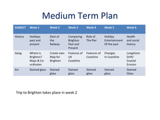
- 1. Medium Term Plan SUBJECT Week 1 Week 2 Week 3 Week 4 Week 5 Week 6 History Holidays past and present Devt of the Railway Comparing Brighton Past and Present Role of The Pier Holiday Entertainment Of the past Health and social history Geog. Where is Brighton? Maps & Coordinates Create own Map for Brighton Features of UK Coastline Features of Coastline Changes In Coastline Longshore Drift/ Coastal Erosion Art Stained glass Stained glass Stained glass Stained glass Stained glass Stained Glass Trip to Brighton takes place in week 2
- 2. Holidays past and present • • • • Where do the children go on holiday? How do they get there? What sort of accommodation do they stay in? What entertainment/amusements do they engage in? • What do they think the Victorians did on holiday? Where did they go? How did they get there?
- 3. History • On the day of the trip the children will be asked to find out facts from the History Trail when visiting the pier. KS2 NC 4(a) Historical Enquiry • They will be asked to find clues in the museum that reveal Brighton’s past – fishing town, then royal retreat in Regency times when the Pavillion was built, then fell from favour under the reign of Victoria and reinvented itself as playground for the middle classes, aided by the development of rail transport linking London to Brighton.
- 4. Development of the Railways
- 5. Brighton: past and present
- 6. Brighton: past and present
- 7. Brighton: past and present • Show pictures of the pier and its attractions/amusements. Ask children to consider how much they have changed over the years. Which attractions do the children think would have originally graced the pier? • Children to write a postcard they would send today from Brighton. Then, imagine they were living in Victorian times. Write about their Victorian holiday.
- 9. Health and Social History KS2 NC unit 2b: Social Diversity Workers supporting the tourist industry didn’t have such an easy life
- 10. Social History
- 11. Social History
- 12. Social History
- 13. Health
- 14. Geography Maps and co-ordinates: maps of Brighton – 2 week unit of work KS2 NC Units 1(a) and 2(e) Geographical Enquiry Skills - what landscape is like, drawing maps KS2 NC Units 3(b) and 3(g) Knowledge of places, location places and fit within wider geographical context http://www.visitbrighton.com/maps-guides-and-interactive/maps http://brightonillustrators.co.uk/portfolios/illustrator/Angela_McKay_portfolio/8/ • Locate Brighton on a map of the UK • Different maps for different purposes: road map, street map, pictorial map, geological, ordnance survey. • Get children to examine these and notice features – scale, legend, contours, grid references. Chn produce concept maps. • What do they think each map would be useful for? • Introduce trip to Brighton – which map would be most useful to us? Why? • Working with maps of Brighton, chn use grid references to find places of interest, and take it in turn to be tourist and local Brighton resident, giving directions to different places of interest. • Chn sketch map of Brighton to follow from Station to Museum.
- 15. Geography Pebbles from Brighton beach • • What do children notice about them? • How do they feel? • Are they all the same? • In what ways do they differ from each other? • Why do you think they are different? • How do you think they got to Brighton beach? • Basic geology of the S. Downs • Beach formation http://www.bbc.co.uk/learningzone/clips/0843 3 • Geog KS2 NC, Unit 4b, Knowledge of patterns and processes
- 16. Geography • Coastal features and Coastal erosion – 2 week unit of work • Geog KS2 NC, Unit 4b, Knowledge of patterns and processes http://www.bbc.co.uk/learningzone/clips/an-introduction-to-thecoastline/8429.html http://www.bbc.co.uk/learningzone/clips/coastlines-erosion/8430.html • • • • • • • Brighton beach - pebbles, groynes. Are all beaches like Brighton? Longshore drift http://www.bbc.co.uk/learningzone/clips/coastlines-longshore-drift/8440.html What other beaches are the children familiar with? Are those beaches pebbly or sandy? Jurassic coast of Dorset – caves, arches, stacks
- 17. Art: the inspiration for the Stained Glass Project