SlideShare une entreprise Scribd logo
1  sur  11
Télécharger pour lire hors ligne
The Auckland Manukau Eastern Transport Initiative (AMETI) is a group of
projects that will give residents of South Eastern suburbs improved transport
choices and better connect them to the rest of Auckland.
The key project is New Zealand’s first urban busway with buses travelling on their own congestion free
lanes between Panmure, Pakuranga and Botany town centres. The busway ensures maximum reliability
and faster travel. The new Panmure Station and 1.5km Te Horeta Road are already delivering benefits.
Additional bus stations at Pakuranga, Botany and Sylvia Park are also planned.
Why is AMETI needed?
The South Eastern suburbs are one of Auckland’s most populated areas. Residents have poor access to
employment opportunities because the transport network cannot properly deal with demand during
peak hours. Residents have limited travel choices resulting in an over-reliance on private vehicle trips.
Public transport is currently a relatively poor option because buses get caught in the same congestion
as cars, resulting in long travel times. The area is not pedestrian or cycle friendly.
Additional Panmure bridge
Panmure
Panmure Basin
Tamaki River
Sylvia Park
Shopping
Centre
The University of
Auckland
PillkingtonRd
Dunn Rd
Green Rd
Pleasant View
JellicoeRd
MorrinRd
Coates C
res
Hobson St
Panm
ure
Bridge
Merton Rd
Ellerslie Panmure Hwy
MtWellingtonHwy
Waipuna Rd
Mou
ntain
Rd
Ireland Rd
LagoonDr
Pakuranga Rd
HarrisRd
UdysRd
Reeves Rd
GossamerDr
Trugood
Dr
Botany
Waipuna Bridge
Ti Rakau Dr
Pakuranga Rd
TiRa
kau
Dr
New Panmure
intersection
Te Horeta Road
Panmure Station new
bus/rail interchange
(now open)
Panmure to Pakuranga
north side busway
10
Sylvia Park bus
route improvements
10A
Bus Station
Gossamer
intersection
improvements1
Shared cycle lanes
and footpath
Busway route
options proposed
Te Horeta Rd extension
to Glen Innes (proposed)
Pakuranga
to Botany
busway
New Sylvia Park
bus station
Trugood
intersection
improvements
Dedicated cycle lane
Busway route
options proposed
Reeves Rd
flyover
Mt Wellington
Panmure
Sunnyhills
Pakuranga
To Botany
About AMETI
Features and benefits
•	 Improved transport options by making
public transport, walking and cycling
realistic and safe choices.
•	 Better connections within the area and to
the rest of Auckland.
•	 Bus travel times reliable at any time of
the day.
•	 Buses every five to 10 minutes between
Panmure and Pakuranga.
•	 Pakuranga to Britomart 27 minutes by bus/
train, at least eight minutes quicker than
current travel times.
•	 Botany to Britomart 38 minutes by bus/train,
17 minutes quicker than current travel times.
•	 AMETI area public transport use projected to
increase to 7.4 million a year by 2041, more
than the current Northern Busway patronage.
•	 Shorter walking distances around Panmure
roundabout and between the town centre
and station.
Key
Stage 1 Panmure (complete)
l Te Horeta Rd
l New Panmure Station
Stage 2
l New Panmure Intersection
l New Panmure Bridge
l Busway Lagoon Dr  Pakuranga Rd
Shared cycle lanes
and footpath
Dedicated cycle lane
Future developments
Stage One Panmure – complete
Train and bus passengers, drivers, cyclists
and pedestrians are now using the major
new transport infrastructure built in Panmure
for the first stage of AMETI. The new station
saw a doubling in passenger numbers
since opening and an increase in people
transferring.
Stage One improvements include
•	 New Panmure Station – more shelter
and easy transfers between bus and train.
•	 Te Horeta Road – a new link between
Morrin Rd and Mt Wellington Highway,
cutting peak journey times.
•	 New bridges on Mountain Road,
Ellerslie-Panmure Highway and for Panmure
Station.
•	 New cycle lanes, shared path and
footpaths.
•	 Van Damme’s Lagoon reserve upgrade.
Auckland Transport plans to apply for consents for the projects between
Panmure roundabout and the intersection of Pakuranga Road/Ti Rakau
Drive in April 2015. The projects include
•	 Upgrading Panmure roundabout to an intersection with traffic lights.
•	 Building the Panmure Station to Pakuranga section of New Zealand’s first dedicated urban
busway; separate from general traffic.
•	 Building a new cycle and pedestrian link between Panmure and Pakuranga along Lagoon Drive
and Pakuranga Road.
•	 Building a new Panmure busway bridge next to the existing road bridge with a wide shared
path for cyclists and pedestrians.
Additional Panmure bridge
Panmure
Panmure
Basin
Tamaki River
Sylvia Park
Shopping
Centre
PillkingtonRd
Dunn Rd
Green Rd
Pleasant View
JellicoeRd
MorrinRd
Coates C
res
Hobson St
Panm
ure
Bridge
Ellerslie Panmure Hwy
MtWellingtonHwy
Waipuna Rd
Mou
ntain
Rd
Ireland Rd
LagoonDr
Reeves Rd
Waipuna Bridge
TiRakauDr
New Panmure
intersection
Panmure to Pakuranga
north side busway
10
10A
Shared cycle lanes
and footpath
Dedicated cycle lane
Pakuranga Rd
Mt Wellington
Panmure
Pakuranga
Stage 2a Panmure to Pakuranga
Features and benefits
•	 The busway between Panmure and Pakuranga will provide a fast,
frequent and reliable way to travel between Panmure and Pakuranga
and the rest of Auckland.
•	 Reliable and quick transport option separate from general traffic.
•	 Removal of the bottleneck at Panmure roundabout, with a safer
signalised intersection keeping traffic moving.
•	 Easier to walk or cycle around Panmure. The new intersection
will have direct crossings across all roads, and will reduce walking
distances, for example from the current 500m to 50m between
Ireland and Mountain Roads.
•	 Priority for vehicles using Lagoon Drive making it a more attractive
route for through traffic.
•	 New cycle lanes and footpaths connecting Panmure and Pakuranga.
•	 Avoids “pinch points” such as merging with general traffic and
pedestrian crossings leading to faster journey times.
•	 An improved town centre environment and enhanced connections
with Panmure Station.
Key
Stage 2a
l New Panmure Intersection
l New Panmure Bridge
l Busway Lagoon Dr  Pakuranga Rd
Shared cycle lanes
and footpath
Dedicated cycle lane
Future developments
History and Milestones
2006 2007 2008 – 2010 2010 Dec 2010 April 2011
AMETI established
by joint project
partners Auckland
City Council,
Manukau City
Council and
Auckland Regional
Transport
Authority.
Consultation
on preliminary
options
Consultation on
preferred route/
option
Consultation on
design
Auckland
Transport
established
Public
consultation
Scheme
asessment and
design
Public
consultation
Scheme
asessment and
design
Mar 2015 Apr 2015 Late 2015
Public
consultation
Notices of
Requirement and
resource consents
lodged – Stage
2a Panmure to
Pakuranga
NoR publicly
notified for
submissions,
followed by
hearing
Dec 2011
Public
consultation
Scheme
asessment and
design
Public
consultation
Scheme
asessment and
design
April 2012 Sep 2012 July 2013
Public
consultation
Scheme
asessment and
design
Public
consultation
Scheme
asessment and
design
Panmure Bridge
Features and benefits
•	 Two 3.5m busway lanes.
•	 4.3m shared cycle/pedestrian path.
•	 Viewing platforms where people can
pause safely outside of the flow of
pedestrians and cyclists.
•	 Preservation of historic bridge
turnstyle.
•	 The new busway bridge will be
constructed 4.8m to the north of the
existing Panmure Bridge. This will
allow for the existing bridge’s future
four lane replacement.
A new bridge is proposed on the northern side of the current Panmure Bridge
to provide for the busway and a combined pedestrian and cycle path.
The existing bridge has no dedicated cycle facilities and the narrow footpath makes walking across
it unpleasant. It is also too narrow to provide for a separate two lane busway. The existing bridge is
scheduled for replacement in 2035 to bring it up to seismic standards. Until then the current peak time
lanes will remain for private vehicles.
What you said
•	 Minimise impact on the culturally significant
Mokoia Pa.
•	 Provide cycle and pedestrian facilities on
new bridge.
•	 Improve navigation on the Tamaki Estuary.
What has been done
•	 Bridge beams designed to reduce excavation
in the pa.
•	 Cycle and pedestrian facilities separated at the
Pa to avoid excavation.
•	 The busway bridge will be 1.5m higher than the
existing Panmure Bridge which will minimise
excavation in the historic Mokoia Pa.
•	 Piers widened and bridge higher to enable
better navigation
•	 Cycle and pedestrian path provided on bridge.
Separated from bridge to minimise excavation
at the pa.
Panmure Intersection
Features and benefits
•	 Improves safety – bus priority
on dedicated busway; more
pedestrian and cyclists crossings;
improves vehicular movement
through intersection.
•	 Town centre will be better
connected to Panmure station,
with shorter walking distances.
•	 On and off street cycle facilities.
•	 Majority of current traffic
movements remain, however the
right turn out of Jellicoe Road
will be via Mountain Road/Forge
Way instead.
•	 Prioritises the movement of
vehicles along Lagoon Drive
and Ellerslie Panmure Highway.
The new 1.5km Te Horeta Road has reduced traffic through the Panmure roundabout via
Jellicoe Road and Ellerslie-Panmure Highway. This allows the roundabout to be replaced
with an intersection with traffic and bus priority lane to be created.
What you said
•	 Crossing distances too long.
•	 Want right turn from Lagoon Dr.
•	 Keep Ireland Rd access.
•	 Keep Jellicoe Rd open.
•	 Want to be able to u-turn on Queens Rd.
What has been done
•	 Staggered crossings introduced.
•	 Right turn from Lagoon Dr permitted.
•	 Ireland Rd access remains.
•	 Jellicoe Rd open, no right turn, access to
Ellerslie-Panmure Highway via re-aligned
Mountain Rd.
•	 U-Turn on Queens Rd added subject to
road safety reviews.
Panmure
intersection
(proposed)
Ellerslie Panmure Highway
Ireland
Rd
Queens Rd
Lagoon Dr
JellicoeRd
Features
•	 General traffic lanes reduced
to one in each direction,
made possible by the
new Panmure intersection
improving traffic flows.
•	 New access to rear of some
Queens Road shops via
Korma Lane.
•	 The southern side of
Lagoon Drive remains
mostly untouched to avoid
significant, environmental,
geological and
archaeological features.
•	 New signalised intersections
with bus stops at Basin View
Lane and Church Crescent.
•	 A new access way from
Bridge Street, at the end
of the cul de sac, for eight
properties that currently have
property access from Church
Crescent.
•	 Additional signalised
pedestrian crossings at
Basin View Lane and Church
Crescent.
•	 New access via Domain Road
to Lagoon Stadium/squash
courts for three properties
that currently have access
from Lagoon Drive.
Lagoon Drive
The busway and shared cycle and footpath
(separated from busway and traffic) will be
created on Lagoon Drive by widening on the
northern cliff side, avoiding impacts on the basin.
Lagoon Drive Busway Typical Section
Footpath Cyclepath Two way bus lanes Traffic lanes
Separation
4.3m 3.5m 3.5m 3m 3m
Pakuranga Road
Pakuranga Road Busway Typical Section
Footpath FootpathCyclepath Planted
berm
BermTwo way bus lanes Traffic lanes Traffic lanes
Separation
Separation
2m 3m varies 3.5m 3.5m 3m 3m 3m 3m existing1m 1m
Features and benefits
•	 Faster connections to Pakuranga, Howick and later to Botany.
•	 Safer access to Pakuranga Road for local residents.
•	 Proposed new public park at 24 Pakuranga Road.
•	 Safer cycling along Pakuranga Road to Panmure town centre.
•	 Improved water quality by treatment of stormwater runoff using planted berms. KerswillPlace
Signalised intersection
New connection
Millen Ave
Signalised intersection Williams A
ve
Closed intersection
Latham Ave
Closed intersection
Tamaki Bay Dr
Signalised intersection
TiRakau
D
r
Pakuranga
Rd
DillimoreAve
Proposed new park area
Footpath (2m)
Cycle lanes (3m)
Bus lanes (3.5m)
Bus stop area
Required land take
Legend
From Panmure Bridge the Pakuranga busway will provide new infrastructure
for buses, cyclists and pedestrians.
It will run on the north side of Pakuranga Road with a bus stop near the Millen Avenue intersection.
Signalised intersections at Kerswill Place, Millen Avenue and Williams Avenue will improve overall
traffic safety and provide safe access for cyclists and pedestrians.
Because there will be no access to properties across the busway, there will be access changes to
Pakuranga Road. This will also improve traffic safety.
•	 Tamaki Bay Drive will be converted into a cul de sac at the Pakuranga Road end with access via
Williams Avenue (at a signalised intersection).
•	 Signalise current give way intersection at Kerswill Place.
•	 Vehicle access at the Pakuranga end of the Panmure bridge will change on the northern side.
•	 Dillimore Avenue and Latham Avenue will be connected. Latham Avenue will be converted into a
cul de sac at the Pakuranga Road end. Access to Pakuranga Road will be via Millen Avenue at a
signalised intersection.
Reserve land taken
Proposed new park area.
24 Pakuranga Road.
Environmental effects
A range of technical specialist reports are being prepared to identify
and assess the potential effects of the project during construction
and operation.
These reports will include recommendations for mitigation measures and/or consent
conditions to manage the identified effects. The measures and/or conditions will form part
of the Notice of Requirement and resource consent applications for the project. These will
be publicly notified, providing an opportunity for the public to make a submission and be
heard at an official hearing.
If you have questions on how these effects may affect you and your property please talk
to one of the Project Team.
Assessment Approach Purpose and Mitigation
Traffic and Transport effects Assesses effects of proposed design on traffic
movements locally and across the wider network,
including for buses, cyclists and pedestrians, during
construction and operation.
Influences the proposed design and methods
to manage traffic effects.
Recommends a Temporary Traffic Management
Plan to manage construction traffic effects.
Noise and Vibration Assesses effects of construction and operation
noise and vibration against relevant national and
international standards and guidelines.
Identifies solutions to meet relevant noise
standards / guidelines, including road
surfacing, noise walls and possibly building
modifications. Recommends a Construction
Noise and Vibration Management Plan.
Landscape Assesses the effects of the design on the existing
landscape and identified natural features or values
of the area.
Informs the design, identifies landscape
effects and methods to avoid or mitigate
them including landscaping treatment
along the alignment.
Archaeology and Heritage Assesses effects of the design on known and
unknown archaeological site and places and
recognised heritage features.
Informs the design to avoid sites where
possible. Recommends Management Plans
and conditions for pre-construction
investigations, accidental archaeological
discovery and monitoring and heritage
feature preservation.
Stormwater Assesses effects of stormwater discharges
(runoff, flooding, quality and volume) from
the proposed design.
Informs selection of the best practicable
option for stormwater conveyance,
treatment and attenuation.
Erosion and Sediment Control Design erosion and sediment controls
in accordance with regional guidance
document (TP90)
To manage effects by avoid erosion,
where possible, and minimising sediment
discharges to the coast.
Air Assesses effects of construction and operational air
quality against national and international standards.
Identifies dust management measures during
construction. Informs design and methods to
manage operational air quality effects.
Ecology Assesses effects of the project operation and
construction on ecological values of the area.
Recommends management plans and design
mitigations to minimise scour and sediments
discharges to the coast.
Trees Identifies the effects of the proposed design
on protected trees.
Recommends tree protection measures and
replacement planting.
Coastal Processes Assesses effects of construction works and
structures and permanent structures (eg. bridges)
on coastal processes.
Informs design of coastal structures and the
methodology for construction works the
coastal area.
Stormwater and landscaping
Adding the busway, cycle and pedestrian facilities will generate
more stormwater runoff. Currently rain falling on Panmure
and Pakuranga roads discharges untreated to the surrounding
waterways. Pollutants and sediment in the water are detrimental
to the ecology of the waterways.
The AMETI busway project aims to treat and remove sediment from runoff generated
by the new impermeable surfaces. Where topography allows, the project will also seek
to treat existing runoff. As a minimum, stormwater will be treated to the new Proposed
Auckland Unitary Plan standards.
Along Pakuranga Road, stormwater treatment will be carried out by road-side planting
as opposed to using the more expensive option of buried filter tanks. This will enhance
green spaces in the area.
Kerbs allow stormwater
to enter the berm.
Planted berm to treat
stormwater runoff.
Treated water is directed
out to discharge points.
Changes to AMETI project timing 
Pakuranga town centre busway route
Auckland Transport is changing the timing of AMETI projects to open the full South Eastern
Busway to Botany earlier than the previously planned 2028 completion and investigate extending
bus lanes to Highland Park.
Recent work has identified that the busway can operate through Pakuranga town centre without
the need to build Reeves Road flyover first.
This allows funding to be shifted to deliver more public transport improvements sooner by
deferring the $170 million flyover. Targeted traffic improvements will also be made to address
congestion at the intersections of Ti Rakau Drive/Pakuranga Road and Ti Rakau Drive/Pakuranga
Highway.
The change supports the roll out of the new public transport network in 2016 and reflects
Auckland Transport prioritising the delivery of rapid, high frequency public transport. It will not
require extra funding to achieve.
Pakuranga town centre busway route
Work is continuing to develop options for the route the busway takes through the Pakuranga
town centre area.
The options are a route via Pakuranga Road and William Roberts Road, and the current proposed
route via Ti Rakau Drive. Both options will include intersection and other improvements to ensure
improvements in bus travel times and reliability.
Next steps
•	 Continue investigations and design to identify a preferred route.
•	 Consultation and scheme design to further develop preferred route.
•	 Consent application.
Additional Panmure bridge
Panmure
Panmure Basin
Tamaki River
Sylvia Park
Shopping
Centre
Green Rd
Pleasant View
Jellico
Panm
ure
Bridge
Ellerslie Panmure Hwy
MtWellingtonHwy
Waipuna Rd
in
Rd
Ireland Rd
LagoonDr
Pakuranga Rd
UdysRd
Reeves Rd
Waipuna Bridge
Ti Rak
Pakuranga Rd
TiRa
kau
Dr
New Panmure
intersection
Panmure to Pakuranga
north side busway
10
Sylvia Park bus
route improvements
10A
Bus Station
1
Shared cycle lanes
and footpath
Busway route
options proposed
Pakuranga
to Botany
busway
New Sylvia Park
bus station
Trugood
intersection
Dedicated cycle lane
Busway route
options proposed
Reeves Rd
flyover
Mt Wellington
Panmure
Sunnyhills
Pakuranga
Key
Stage 1 Panmure (complete)
l Te Horeta Rd
l New Panmure Station
Stage 2
l New Panmure Intersection
l New Panmure Bridge
l Busway Lagoon Dr  Pakuranga Rd
Shared cycle lanes
and footpath
Dedicated cycle lane
Future developments
Pakuranga Road Busway Typical Section
Footpath FootpathCyclepath Planted
berm
BermTwo way bus lanes Traffic lanes Traffic lanes
Separation
Separation
2m 3m varies 3.5m 3.5m 3m 3m 3m 3m existing1m 1m
Cycling and Walking
Lagoon Drive Busway Typical Section
Footpath Cyclepath Two way bus lanes Traffic lanes
Separation
4.3m 3.5m 3.5m 3m 3m
Improving walking and cycling facilities for the community to make them safer and more
attractive to use, is one of the main aims of AMETI.
Separated cycle paths or lanes and footpaths will allow people to walk or cycle off road between Panmure, Pakuranga and
on to Pigeon Mountain by connecting to the Pakuranga Rotary Walkway.
Features
•	 Panmure to Pakuranga Road – 4.3m wide shared path along Lagoon Drive and on the new Panmure busway bridge
•	 Pakuranga Road – 3m wide cycle path separated from busway and traffic by planted berm. 2m wide foot path separated
from cycle path.
•	 Safe signalised crossings at intersections for pedestrians and cyclists
•	 Connections to new Panmure cycle and foot paths on Ellerslie-Panmure Highway and Te Horeta Road, connection to
Pakuranga Rotary Walkway.
Future plans include separated cycle lanes and wider footpaths from Pakuranga town centre to Botany town centre.

Contenu connexe

En vedette

Leisure marketing: Transportation
Leisure marketing: TransportationLeisure marketing: Transportation
Leisure marketing: Transportation
natashabonu
 
Afa Interpretation Of Financial Statements Sbs Transist Vs Smrt
Afa Interpretation Of Financial Statements   Sbs Transist Vs SmrtAfa Interpretation Of Financial Statements   Sbs Transist Vs Smrt
Afa Interpretation Of Financial Statements Sbs Transist Vs Smrt
ruoting
 
Urban mobility, livelihoods and transport in Dar Es Salaam City: exploring ch...
Urban mobility, livelihoods and transport in Dar Es Salaam City: exploring ch...Urban mobility, livelihoods and transport in Dar Es Salaam City: exploring ch...
Urban mobility, livelihoods and transport in Dar Es Salaam City: exploring ch...
Institute for Transport Studies (ITS)
 
KA6564 Assignment 4 - Urban Public Transport Report
KA6564 Assignment 4 - Urban Public Transport ReportKA6564 Assignment 4 - Urban Public Transport Report
KA6564 Assignment 4 - Urban Public Transport Report
armada7000
 

En vedette (20)

Asean quiz championship_2012
Asean quiz championship_2012Asean quiz championship_2012
Asean quiz championship_2012
 
Trek au Népal à travers l'oeil de nos enfants
Trek au Népal à travers l'oeil de nos enfantsTrek au Népal à travers l'oeil de nos enfants
Trek au Népal à travers l'oeil de nos enfants
 
The Current Transport Policy Environment
The Current Transport Policy Environment The Current Transport Policy Environment
The Current Transport Policy Environment
 
Leisure marketing: Transportation
Leisure marketing: TransportationLeisure marketing: Transportation
Leisure marketing: Transportation
 
Afa Interpretation Of Financial Statements Sbs Transist Vs Smrt
Afa Interpretation Of Financial Statements   Sbs Transist Vs SmrtAfa Interpretation Of Financial Statements   Sbs Transist Vs Smrt
Afa Interpretation Of Financial Statements Sbs Transist Vs Smrt
 
Ganga Sagar Mela
Ganga Sagar MelaGanga Sagar Mela
Ganga Sagar Mela
 
SA Taxi market context
SA Taxi market contextSA Taxi market context
SA Taxi market context
 
Urban mobility, livelihoods and transport in Dar Es Salaam City: exploring ch...
Urban mobility, livelihoods and transport in Dar Es Salaam City: exploring ch...Urban mobility, livelihoods and transport in Dar Es Salaam City: exploring ch...
Urban mobility, livelihoods and transport in Dar Es Salaam City: exploring ch...
 
2011 City of Buenos Aires Achievements: Sustainable Mobility Plan
2011 City of Buenos Aires Achievements: Sustainable Mobility Plan2011 City of Buenos Aires Achievements: Sustainable Mobility Plan
2011 City of Buenos Aires Achievements: Sustainable Mobility Plan
 
Bangalore - Metro is not the solution
Bangalore - Metro is not the solutionBangalore - Metro is not the solution
Bangalore - Metro is not the solution
 
CUSTOMER SATISFACTION LEVELS IN PUNE MUNICIPAL TRANSPORT
CUSTOMER SATISFACTION LEVELS IN PUNE MUNICIPAL TRANSPORTCUSTOMER SATISFACTION LEVELS IN PUNE MUNICIPAL TRANSPORT
CUSTOMER SATISFACTION LEVELS IN PUNE MUNICIPAL TRANSPORT
 
Transport Or Transportation
Transport Or TransportationTransport Or Transportation
Transport Or Transportation
 
Etude IFOP "Mobilités des français : pratiques et prespectives"
Etude IFOP "Mobilités des français : pratiques et prespectives"Etude IFOP "Mobilités des français : pratiques et prespectives"
Etude IFOP "Mobilités des français : pratiques et prespectives"
 
Dubai - City of Emirates
Dubai - City of EmiratesDubai - City of Emirates
Dubai - City of Emirates
 
Means Of Transport
Means Of TransportMeans Of Transport
Means Of Transport
 
Metro vs. Bus
Metro vs. BusMetro vs. Bus
Metro vs. Bus
 
Bus Rapid Transit (BRT) in Gauteng, S.A.
Bus Rapid Transit (BRT) in Gauteng, S.A.Bus Rapid Transit (BRT) in Gauteng, S.A.
Bus Rapid Transit (BRT) in Gauteng, S.A.
 
KA6564 Assignment 4 - Urban Public Transport Report
KA6564 Assignment 4 - Urban Public Transport ReportKA6564 Assignment 4 - Urban Public Transport Report
KA6564 Assignment 4 - Urban Public Transport Report
 
OUR WONDERFUL WORLD/ CONTENT 2 Means of-transport
OUR WONDERFUL WORLD/ CONTENT 2 Means of-transportOUR WONDERFUL WORLD/ CONTENT 2 Means of-transport
OUR WONDERFUL WORLD/ CONTENT 2 Means of-transport
 
Muet Workshop Writing
Muet   Workshop WritingMuet   Workshop Writing
Muet Workshop Writing
 

Similaire à AMETI project information board

Cedarvale station open house for website final2
Cedarvale station open house for website final2Cedarvale station open house for website final2
Cedarvale station open house for website final2
Crosstown TO
 
Railways Africa July/Aug 2010
Railways Africa July/Aug 2010Railways Africa July/Aug 2010
Railways Africa July/Aug 2010
Railways Africa
 

Similaire à AMETI project information board (20)

North East Bicycle Corridor linking Chandle Hiqhway and Alexandra Parade
North East Bicycle Corridor linking Chandle Hiqhway and Alexandra ParadeNorth East Bicycle Corridor linking Chandle Hiqhway and Alexandra Parade
North East Bicycle Corridor linking Chandle Hiqhway and Alexandra Parade
 
Ottawa fall construction season 2016
Ottawa fall construction season 2016Ottawa fall construction season 2016
Ottawa fall construction season 2016
 
February Transit Update Presentation
February Transit Update PresentationFebruary Transit Update Presentation
February Transit Update Presentation
 
City of Gold Coast - Proposed active transport improvements for Golden Four D...
City of Gold Coast - Proposed active transport improvements for Golden Four D...City of Gold Coast - Proposed active transport improvements for Golden Four D...
City of Gold Coast - Proposed active transport improvements for Golden Four D...
 
BigHertsBigIdeas for Business Network Event 31/1/14
BigHertsBigIdeas for Business Network Event 31/1/14BigHertsBigIdeas for Business Network Event 31/1/14
BigHertsBigIdeas for Business Network Event 31/1/14
 
Eastern Works Open House
Eastern Works Open House Eastern Works Open House
Eastern Works Open House
 
Cedarvale station open house for website final2
Cedarvale station open house for website final2Cedarvale station open house for website final2
Cedarvale station open house for website final2
 
The visionaire ec
The visionaire ecThe visionaire ec
The visionaire ec
 
The visionaire ec
The visionaire ecThe visionaire ec
The visionaire ec
 
Graduating susp bridge to ropeways and cable cars in Nepal by Bhim Updhyaya
Graduating susp bridge to ropeways and cable cars in Nepal by Bhim UpdhyayaGraduating susp bridge to ropeways and cable cars in Nepal by Bhim Updhyaya
Graduating susp bridge to ropeways and cable cars in Nepal by Bhim Updhyaya
 
REimagining Yonge Street - Public Open House 1 Display Panels [may 25-16]
REimagining Yonge Street - Public Open House 1 Display Panels [may 25-16]REimagining Yonge Street - Public Open House 1 Display Panels [may 25-16]
REimagining Yonge Street - Public Open House 1 Display Panels [may 25-16]
 
Perth Stadium community briefing presentation
Perth Stadium community briefing presentationPerth Stadium community briefing presentation
Perth Stadium community briefing presentation
 
Community liason-group-presentation-10-02-2015
Community liason-group-presentation-10-02-2015Community liason-group-presentation-10-02-2015
Community liason-group-presentation-10-02-2015
 
Oxford City Centre Movement and Public Realm Strategy
Oxford City Centre Movement and Public Realm StrategyOxford City Centre Movement and Public Realm Strategy
Oxford City Centre Movement and Public Realm Strategy
 
The long way home
The long way homeThe long way home
The long way home
 
East Cowes - Proposed development - Solent Gateways - Dec 2014
East Cowes - Proposed development - Solent Gateways - Dec 2014East Cowes - Proposed development - Solent Gateways - Dec 2014
East Cowes - Proposed development - Solent Gateways - Dec 2014
 
planning of central railway station
planning of central railway stationplanning of central railway station
planning of central railway station
 
Integrated transport - investing in Auckland's future
Integrated transport - investing in Auckland's futureIntegrated transport - investing in Auckland's future
Integrated transport - investing in Auckland's future
 
OPDC revised draft Local Plan presentation - Transport
OPDC revised draft Local Plan presentation - TransportOPDC revised draft Local Plan presentation - Transport
OPDC revised draft Local Plan presentation - Transport
 
Railways Africa July/Aug 2010
Railways Africa July/Aug 2010Railways Africa July/Aug 2010
Railways Africa July/Aug 2010
 

AMETI project information board

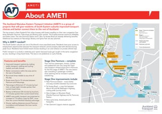
  • 1. The Auckland Manukau Eastern Transport Initiative (AMETI) is a group of projects that will give residents of South Eastern suburbs improved transport choices and better connect them to the rest of Auckland. The key project is New Zealand’s first urban busway with buses travelling on their own congestion free lanes between Panmure, Pakuranga and Botany town centres. The busway ensures maximum reliability and faster travel. The new Panmure Station and 1.5km Te Horeta Road are already delivering benefits. Additional bus stations at Pakuranga, Botany and Sylvia Park are also planned. Why is AMETI needed? The South Eastern suburbs are one of Auckland’s most populated areas. Residents have poor access to employment opportunities because the transport network cannot properly deal with demand during peak hours. Residents have limited travel choices resulting in an over-reliance on private vehicle trips. Public transport is currently a relatively poor option because buses get caught in the same congestion as cars, resulting in long travel times. The area is not pedestrian or cycle friendly. Additional Panmure bridge Panmure Panmure Basin Tamaki River Sylvia Park Shopping Centre The University of Auckland PillkingtonRd Dunn Rd Green Rd Pleasant View JellicoeRd MorrinRd Coates C res Hobson St Panm ure Bridge Merton Rd Ellerslie Panmure Hwy MtWellingtonHwy Waipuna Rd Mou ntain Rd Ireland Rd LagoonDr Pakuranga Rd HarrisRd UdysRd Reeves Rd GossamerDr Trugood Dr Botany Waipuna Bridge Ti Rakau Dr Pakuranga Rd TiRa kau Dr New Panmure intersection Te Horeta Road Panmure Station new bus/rail interchange (now open) Panmure to Pakuranga north side busway 10 Sylvia Park bus route improvements 10A Bus Station Gossamer intersection improvements1 Shared cycle lanes and footpath Busway route options proposed Te Horeta Rd extension to Glen Innes (proposed) Pakuranga to Botany busway New Sylvia Park bus station Trugood intersection improvements Dedicated cycle lane Busway route options proposed Reeves Rd flyover Mt Wellington Panmure Sunnyhills Pakuranga To Botany About AMETI Features and benefits • Improved transport options by making public transport, walking and cycling realistic and safe choices. • Better connections within the area and to the rest of Auckland. • Bus travel times reliable at any time of the day. • Buses every five to 10 minutes between Panmure and Pakuranga. • Pakuranga to Britomart 27 minutes by bus/ train, at least eight minutes quicker than current travel times. • Botany to Britomart 38 minutes by bus/train, 17 minutes quicker than current travel times. • AMETI area public transport use projected to increase to 7.4 million a year by 2041, more than the current Northern Busway patronage. • Shorter walking distances around Panmure roundabout and between the town centre and station. Key Stage 1 Panmure (complete) l Te Horeta Rd l New Panmure Station Stage 2 l New Panmure Intersection l New Panmure Bridge l Busway Lagoon Dr Pakuranga Rd Shared cycle lanes and footpath Dedicated cycle lane Future developments Stage One Panmure – complete Train and bus passengers, drivers, cyclists and pedestrians are now using the major new transport infrastructure built in Panmure for the first stage of AMETI. The new station saw a doubling in passenger numbers since opening and an increase in people transferring. Stage One improvements include • New Panmure Station – more shelter and easy transfers between bus and train. • Te Horeta Road – a new link between Morrin Rd and Mt Wellington Highway, cutting peak journey times. • New bridges on Mountain Road, Ellerslie-Panmure Highway and for Panmure Station. • New cycle lanes, shared path and footpaths. • Van Damme’s Lagoon reserve upgrade.
  • 2. Auckland Transport plans to apply for consents for the projects between Panmure roundabout and the intersection of Pakuranga Road/Ti Rakau Drive in April 2015. The projects include • Upgrading Panmure roundabout to an intersection with traffic lights. • Building the Panmure Station to Pakuranga section of New Zealand’s first dedicated urban busway; separate from general traffic. • Building a new cycle and pedestrian link between Panmure and Pakuranga along Lagoon Drive and Pakuranga Road. • Building a new Panmure busway bridge next to the existing road bridge with a wide shared path for cyclists and pedestrians. Additional Panmure bridge Panmure Panmure Basin Tamaki River Sylvia Park Shopping Centre PillkingtonRd Dunn Rd Green Rd Pleasant View JellicoeRd MorrinRd Coates C res Hobson St Panm ure Bridge Ellerslie Panmure Hwy MtWellingtonHwy Waipuna Rd Mou ntain Rd Ireland Rd LagoonDr Reeves Rd Waipuna Bridge TiRakauDr New Panmure intersection Panmure to Pakuranga north side busway 10 10A Shared cycle lanes and footpath Dedicated cycle lane Pakuranga Rd Mt Wellington Panmure Pakuranga Stage 2a Panmure to Pakuranga Features and benefits • The busway between Panmure and Pakuranga will provide a fast, frequent and reliable way to travel between Panmure and Pakuranga and the rest of Auckland. • Reliable and quick transport option separate from general traffic. • Removal of the bottleneck at Panmure roundabout, with a safer signalised intersection keeping traffic moving. • Easier to walk or cycle around Panmure. The new intersection will have direct crossings across all roads, and will reduce walking distances, for example from the current 500m to 50m between Ireland and Mountain Roads. • Priority for vehicles using Lagoon Drive making it a more attractive route for through traffic. • New cycle lanes and footpaths connecting Panmure and Pakuranga. • Avoids “pinch points” such as merging with general traffic and pedestrian crossings leading to faster journey times. • An improved town centre environment and enhanced connections with Panmure Station. Key Stage 2a l New Panmure Intersection l New Panmure Bridge l Busway Lagoon Dr Pakuranga Rd Shared cycle lanes and footpath Dedicated cycle lane Future developments
  • 3. History and Milestones 2006 2007 2008 – 2010 2010 Dec 2010 April 2011 AMETI established by joint project partners Auckland City Council, Manukau City Council and Auckland Regional Transport Authority. Consultation on preliminary options Consultation on preferred route/ option Consultation on design Auckland Transport established Public consultation Scheme asessment and design Public consultation Scheme asessment and design Mar 2015 Apr 2015 Late 2015 Public consultation Notices of Requirement and resource consents lodged – Stage 2a Panmure to Pakuranga NoR publicly notified for submissions, followed by hearing Dec 2011 Public consultation Scheme asessment and design Public consultation Scheme asessment and design April 2012 Sep 2012 July 2013 Public consultation Scheme asessment and design Public consultation Scheme asessment and design
  • 4. Panmure Bridge Features and benefits • Two 3.5m busway lanes. • 4.3m shared cycle/pedestrian path. • Viewing platforms where people can pause safely outside of the flow of pedestrians and cyclists. • Preservation of historic bridge turnstyle. • The new busway bridge will be constructed 4.8m to the north of the existing Panmure Bridge. This will allow for the existing bridge’s future four lane replacement. A new bridge is proposed on the northern side of the current Panmure Bridge to provide for the busway and a combined pedestrian and cycle path. The existing bridge has no dedicated cycle facilities and the narrow footpath makes walking across it unpleasant. It is also too narrow to provide for a separate two lane busway. The existing bridge is scheduled for replacement in 2035 to bring it up to seismic standards. Until then the current peak time lanes will remain for private vehicles. What you said • Minimise impact on the culturally significant Mokoia Pa. • Provide cycle and pedestrian facilities on new bridge. • Improve navigation on the Tamaki Estuary. What has been done • Bridge beams designed to reduce excavation in the pa. • Cycle and pedestrian facilities separated at the Pa to avoid excavation. • The busway bridge will be 1.5m higher than the existing Panmure Bridge which will minimise excavation in the historic Mokoia Pa. • Piers widened and bridge higher to enable better navigation • Cycle and pedestrian path provided on bridge. Separated from bridge to minimise excavation at the pa.
  • 5. Panmure Intersection Features and benefits • Improves safety – bus priority on dedicated busway; more pedestrian and cyclists crossings; improves vehicular movement through intersection. • Town centre will be better connected to Panmure station, with shorter walking distances. • On and off street cycle facilities. • Majority of current traffic movements remain, however the right turn out of Jellicoe Road will be via Mountain Road/Forge Way instead. • Prioritises the movement of vehicles along Lagoon Drive and Ellerslie Panmure Highway. The new 1.5km Te Horeta Road has reduced traffic through the Panmure roundabout via Jellicoe Road and Ellerslie-Panmure Highway. This allows the roundabout to be replaced with an intersection with traffic and bus priority lane to be created. What you said • Crossing distances too long. • Want right turn from Lagoon Dr. • Keep Ireland Rd access. • Keep Jellicoe Rd open. • Want to be able to u-turn on Queens Rd. What has been done • Staggered crossings introduced. • Right turn from Lagoon Dr permitted. • Ireland Rd access remains. • Jellicoe Rd open, no right turn, access to Ellerslie-Panmure Highway via re-aligned Mountain Rd. • U-Turn on Queens Rd added subject to road safety reviews. Panmure intersection (proposed) Ellerslie Panmure Highway Ireland Rd Queens Rd Lagoon Dr JellicoeRd
  • 6. Features • General traffic lanes reduced to one in each direction, made possible by the new Panmure intersection improving traffic flows. • New access to rear of some Queens Road shops via Korma Lane. • The southern side of Lagoon Drive remains mostly untouched to avoid significant, environmental, geological and archaeological features. • New signalised intersections with bus stops at Basin View Lane and Church Crescent. • A new access way from Bridge Street, at the end of the cul de sac, for eight properties that currently have property access from Church Crescent. • Additional signalised pedestrian crossings at Basin View Lane and Church Crescent. • New access via Domain Road to Lagoon Stadium/squash courts for three properties that currently have access from Lagoon Drive. Lagoon Drive The busway and shared cycle and footpath (separated from busway and traffic) will be created on Lagoon Drive by widening on the northern cliff side, avoiding impacts on the basin. Lagoon Drive Busway Typical Section Footpath Cyclepath Two way bus lanes Traffic lanes Separation 4.3m 3.5m 3.5m 3m 3m
  • 7. Pakuranga Road Pakuranga Road Busway Typical Section Footpath FootpathCyclepath Planted berm BermTwo way bus lanes Traffic lanes Traffic lanes Separation Separation 2m 3m varies 3.5m 3.5m 3m 3m 3m 3m existing1m 1m Features and benefits • Faster connections to Pakuranga, Howick and later to Botany. • Safer access to Pakuranga Road for local residents. • Proposed new public park at 24 Pakuranga Road. • Safer cycling along Pakuranga Road to Panmure town centre. • Improved water quality by treatment of stormwater runoff using planted berms. KerswillPlace Signalised intersection Signalised intersection New connection Millen Ave Signalised intersection Williams A ve Closed intersection Latham Ave Closed intersection Tamaki Bay Dr Signalised intersection TiRakau D r Pakuranga Rd DillimoreAve Proposed new park area Footpath (2m) Cycle lanes (3m) Bus lanes (3.5m) Bus stop area Required land take Legend From Panmure Bridge the Pakuranga busway will provide new infrastructure for buses, cyclists and pedestrians. It will run on the north side of Pakuranga Road with a bus stop near the Millen Avenue intersection. Signalised intersections at Kerswill Place, Millen Avenue and Williams Avenue will improve overall traffic safety and provide safe access for cyclists and pedestrians. Because there will be no access to properties across the busway, there will be access changes to Pakuranga Road. This will also improve traffic safety. • Tamaki Bay Drive will be converted into a cul de sac at the Pakuranga Road end with access via Williams Avenue (at a signalised intersection). • Signalise current give way intersection at Kerswill Place. • Vehicle access at the Pakuranga end of the Panmure bridge will change on the northern side. • Dillimore Avenue and Latham Avenue will be connected. Latham Avenue will be converted into a cul de sac at the Pakuranga Road end. Access to Pakuranga Road will be via Millen Avenue at a signalised intersection. Reserve land taken Proposed new park area. 24 Pakuranga Road.
  • 8. Environmental effects A range of technical specialist reports are being prepared to identify and assess the potential effects of the project during construction and operation. These reports will include recommendations for mitigation measures and/or consent conditions to manage the identified effects. The measures and/or conditions will form part of the Notice of Requirement and resource consent applications for the project. These will be publicly notified, providing an opportunity for the public to make a submission and be heard at an official hearing. If you have questions on how these effects may affect you and your property please talk to one of the Project Team. Assessment Approach Purpose and Mitigation Traffic and Transport effects Assesses effects of proposed design on traffic movements locally and across the wider network, including for buses, cyclists and pedestrians, during construction and operation. Influences the proposed design and methods to manage traffic effects. Recommends a Temporary Traffic Management Plan to manage construction traffic effects. Noise and Vibration Assesses effects of construction and operation noise and vibration against relevant national and international standards and guidelines. Identifies solutions to meet relevant noise standards / guidelines, including road surfacing, noise walls and possibly building modifications. Recommends a Construction Noise and Vibration Management Plan. Landscape Assesses the effects of the design on the existing landscape and identified natural features or values of the area. Informs the design, identifies landscape effects and methods to avoid or mitigate them including landscaping treatment along the alignment. Archaeology and Heritage Assesses effects of the design on known and unknown archaeological site and places and recognised heritage features. Informs the design to avoid sites where possible. Recommends Management Plans and conditions for pre-construction investigations, accidental archaeological discovery and monitoring and heritage feature preservation. Stormwater Assesses effects of stormwater discharges (runoff, flooding, quality and volume) from the proposed design. Informs selection of the best practicable option for stormwater conveyance, treatment and attenuation. Erosion and Sediment Control Design erosion and sediment controls in accordance with regional guidance document (TP90) To manage effects by avoid erosion, where possible, and minimising sediment discharges to the coast. Air Assesses effects of construction and operational air quality against national and international standards. Identifies dust management measures during construction. Informs design and methods to manage operational air quality effects. Ecology Assesses effects of the project operation and construction on ecological values of the area. Recommends management plans and design mitigations to minimise scour and sediments discharges to the coast. Trees Identifies the effects of the proposed design on protected trees. Recommends tree protection measures and replacement planting. Coastal Processes Assesses effects of construction works and structures and permanent structures (eg. bridges) on coastal processes. Informs design of coastal structures and the methodology for construction works the coastal area.
  • 9. Stormwater and landscaping Adding the busway, cycle and pedestrian facilities will generate more stormwater runoff. Currently rain falling on Panmure and Pakuranga roads discharges untreated to the surrounding waterways. Pollutants and sediment in the water are detrimental to the ecology of the waterways. The AMETI busway project aims to treat and remove sediment from runoff generated by the new impermeable surfaces. Where topography allows, the project will also seek to treat existing runoff. As a minimum, stormwater will be treated to the new Proposed Auckland Unitary Plan standards. Along Pakuranga Road, stormwater treatment will be carried out by road-side planting as opposed to using the more expensive option of buried filter tanks. This will enhance green spaces in the area. Kerbs allow stormwater to enter the berm. Planted berm to treat stormwater runoff. Treated water is directed out to discharge points.
  • 10. Changes to AMETI project timing Pakuranga town centre busway route Auckland Transport is changing the timing of AMETI projects to open the full South Eastern Busway to Botany earlier than the previously planned 2028 completion and investigate extending bus lanes to Highland Park. Recent work has identified that the busway can operate through Pakuranga town centre without the need to build Reeves Road flyover first. This allows funding to be shifted to deliver more public transport improvements sooner by deferring the $170 million flyover. Targeted traffic improvements will also be made to address congestion at the intersections of Ti Rakau Drive/Pakuranga Road and Ti Rakau Drive/Pakuranga Highway. The change supports the roll out of the new public transport network in 2016 and reflects Auckland Transport prioritising the delivery of rapid, high frequency public transport. It will not require extra funding to achieve. Pakuranga town centre busway route Work is continuing to develop options for the route the busway takes through the Pakuranga town centre area. The options are a route via Pakuranga Road and William Roberts Road, and the current proposed route via Ti Rakau Drive. Both options will include intersection and other improvements to ensure improvements in bus travel times and reliability. Next steps • Continue investigations and design to identify a preferred route. • Consultation and scheme design to further develop preferred route. • Consent application. Additional Panmure bridge Panmure Panmure Basin Tamaki River Sylvia Park Shopping Centre Green Rd Pleasant View Jellico Panm ure Bridge Ellerslie Panmure Hwy MtWellingtonHwy Waipuna Rd in Rd Ireland Rd LagoonDr Pakuranga Rd UdysRd Reeves Rd Waipuna Bridge Ti Rak Pakuranga Rd TiRa kau Dr New Panmure intersection Panmure to Pakuranga north side busway 10 Sylvia Park bus route improvements 10A Bus Station 1 Shared cycle lanes and footpath Busway route options proposed Pakuranga to Botany busway New Sylvia Park bus station Trugood intersection Dedicated cycle lane Busway route options proposed Reeves Rd flyover Mt Wellington Panmure Sunnyhills Pakuranga Key Stage 1 Panmure (complete) l Te Horeta Rd l New Panmure Station Stage 2 l New Panmure Intersection l New Panmure Bridge l Busway Lagoon Dr Pakuranga Rd Shared cycle lanes and footpath Dedicated cycle lane Future developments
  • 11. Pakuranga Road Busway Typical Section Footpath FootpathCyclepath Planted berm BermTwo way bus lanes Traffic lanes Traffic lanes Separation Separation 2m 3m varies 3.5m 3.5m 3m 3m 3m 3m existing1m 1m Cycling and Walking Lagoon Drive Busway Typical Section Footpath Cyclepath Two way bus lanes Traffic lanes Separation 4.3m 3.5m 3.5m 3m 3m Improving walking and cycling facilities for the community to make them safer and more attractive to use, is one of the main aims of AMETI. Separated cycle paths or lanes and footpaths will allow people to walk or cycle off road between Panmure, Pakuranga and on to Pigeon Mountain by connecting to the Pakuranga Rotary Walkway. Features • Panmure to Pakuranga Road – 4.3m wide shared path along Lagoon Drive and on the new Panmure busway bridge • Pakuranga Road – 3m wide cycle path separated from busway and traffic by planted berm. 2m wide foot path separated from cycle path. • Safe signalised crossings at intersections for pedestrians and cyclists • Connections to new Panmure cycle and foot paths on Ellerslie-Panmure Highway and Te Horeta Road, connection to Pakuranga Rotary Walkway. Future plans include separated cycle lanes and wider footpaths from Pakuranga town centre to Botany town centre.