2014 CLCPRO/CRC/SWAC Desert Locust Information Officer workshop
•
0 j'aime•598 vues

National Locust Information Officers from 17 frontline countries affected by the Desert Locust came together for the first time at a 5-day workshop in Agadir, Morocco on 19-23 May 2014. The objective of the workshop was to train participants in using the new eLocust3 system, to become Master Trainers and to discuss issues related to reporting and the RAMSESv4 GIS. The workshop was sponsored by the the FAO regional locust commissions.

Recommandé
Contenu connexe
En vedette
Similaire à 2014 CLCPRO/CRC/SWAC Desert Locust Information Officer workshop
Similaire à 2014 CLCPRO/CRC/SWAC Desert Locust Information Officer workshop (20)
Plus de FAO
Plus de FAO (20)
Dernier
Dernier (20)
2014 CLCPRO/CRC/SWAC Desert Locust Information Officer workshop
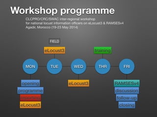
- 1. MON TUE WED THR FRI FIELD eLocust3 trainingeLocust3 eLocust3 reporting RAMSESv4opening programme discussion follow-up closing Workshop programme CLCPRO/CRC/SWAC inter-regional workshop for national locust information officers on eLocust3 & RAMSESv4 Agadir, Morocco (19-23 May 2014)
- 2. REPORTING, DATA & BULLETINS Problems and improvements 2013-2014
- 3. 90% 92% 94% 96% 98% 100% ALG CHD LIB MAU MLI MOR NER EGY ERI ETH OMN SAU SUD YEM IND IRN PAK 2013 2014 Quality ERI OMN SAU SUD YEM
- 4. 85% 90% 95% 100% ALG CHD LIB MAU MLI MOR NER EGY ERI ETH OMN SAU SUD YEM IND IRN PAK 2013 2014 Timeliness NER ERI OMN SAU SUD YEM PAK
- 5. 0 10 20 30 40 50 60 70 ALG CHD LIB MAU MLI MOR NER EGY ERI ETH OMN SAU SUD YEM IND IRN PAK 2013 2014 Number of reports ER 120 CR 330 WR 302
- 6. 0 500 1000 1500 2000 2500 3000 3500 4000 ALG CHD LIB MAU MLI MOR NER EGY ERI ETH OMN SAU SUD YEM IND IRN PAK 2013 2014 RAMSES data (records) ER 6,141 CR 11,346 WR 11,443
- 7. PDF settings for DL Bulletins Adobe Acrobat - SETTINGS Menu - Edit Adobe PDF Settings… 1 2 3 always send DL Bulletins in PDF format (not MS Word)
- 10. From: Ali Babali To: Cressman, Keith (AGPM) Cc: Mehdi Ghaemian; ECLO Subject: Re: Iran"s DL Report No. 123 Date: Saturday, April 05, 2014 10:17:16 AM Dear Keith and ECLO, Thanks for your email, we are surving DL in Jask, Mehdi visited DL situation last week (31 March) and he realized that the Desert Locusts were transient in 20 ha, Desert Locusts were adult and thay were coupling and laying. DL color were brown and yellow. I am going to Jask for seeing situation tomorrow, after that, I'll send to you all of information. It was raning in Jask during last week (more than 100 mm). we estimat that hatching will happend in second half of April. we are going to prepare equipment for control of DL in hopper stage (if it is necessary we will control hoppers). Best Regards, Ali On 3/31/14, ECLO <ECLO@fao.org> wrote: > Dear Mahmoud, > Thanks for the latest report. However, you should mention that adults were > copulating in your summary. In the forecast, you should indicate the > estimated date of hatching. Babali was trained in DLIS how to do this. For what was the exact date & extent of rainfall?
- 11. Food Security Locusts Locusts The Desert Locust (Schistocerca gregaria) is an insect whose distribution area extends from West Africa to India. During invasion periods, adults form swarms that can fly or be carried by wind over great distances. These swarms can wipe out crops located hundreds of kilometers from their places of origin and create starvation conditions in regions that are already financially challenged. The Desert Locust Information Service (DLIS) from the UN Food and Agriculture Organization (FAO) collaborates with the National Locust Units to collate, summarize and analyze field data (e.g., vegetation, rainfall, locust and control information) in order to assess the current situation and forecast the scale, timing and location of locust breeding and migration (more information). The warnings, assessments and forecasts produced by DLIS are used by affected countries to plan survey and control operations and by the international donor community to target assistance, especially during emergencies. In collaboration with DLIS, IRI is developing products to estimate ecological conditions and rainfall events in the Desert Locust recession area. The maps and analysis products below illustrate recent climate conditions, such as rainfall and vegetation, which provide ideal breeding conditions for the locusts. Additional information may be included in the future and we welcome the opportunity to work with others on the further development of these products. Rainfall Analysis Tool A rainfall monitoring product based on daily rainfall estimates from the Climate Prediction Center. Monthly Rainfall Estimates Accumulated rainfall during the most recent month based on estimates from the Climate Prediction Center Morphing technique. Dekadal Rainfall Estimates Accumulated rainfall during the most recent dekad based on estimates from the Climate Prediction Center Morphing technique. Greenness Estimates A critical factor in Locust control is areas which have recently transitioned from desert to vegetation. Greenness is the number of dekads (approximately ten days) passed since vegetation onset. Thus greenness is a measure which highlights this critical transition. MODIS Analysis Tool The images on this page are derived from The Moderate Resolution Imaging Spectroradiometer (MODIS) sensor at 250m spatial resolution provided every 16 days. This interface facilitates access to estimates of vegetation from MODIS images provided by the United States Geological Survey. Images are available for West Africa, East Africa, and Southwest Asia. NASA Worldview Satellite Imagery for Vegetation, Dust Storms, Fires, Drought, Smoke Plumes, Ash Plumes, Air Quality, Severe Storms, and Floods ▼ Maproom Food Security http://iridl.ldeo.columbia.edu/maproom/Food_Security/Locusts/
- 14. From: Ali Babali To: Cressman, Keith (AGPM) Cc: Mehdi Ghaemian; ECLO Subject: Re: Iran"s DL Report No. 123 Date: Saturday, April 05, 2014 10:17:16 AM Dear Keith and ECLO, Thanks for your email, we are surving DL in Jask, Mehdi visited DL situation last week (31 March) and he realized that the Desert Locusts were transient in 20 ha, Desert Locusts were adult and thay were coupling and laying. DL color were brown and yellow. I am going to Jask for seeing situation tomorrow, after that, I'll send to you all of information. It was raning in Jask during last week (more than 100 mm). we estimat that hatching will happend in second half of April. we are going to prepare equipment for control of DL in hopper stage (if it is necessary we will control hoppers). Best Regards, Ali On 3/31/14, ECLO <ECLO@fao.org> wrote: > Dear Mahmoud, > Thanks for the latest report. However, you should mention that adults were > copulating in your summary. In the forecast, you should indicate the > estimated date of hatching. Babali was trained in DLIS how to do this. For > the future, whenever adults are seen copulating or laying, or if there are 26 March 2014 150 km Jask
- 15. TIPS TO BETTER REPORTING 1. Do not send duplicate data 2. Always send a summary with the data 3. Do not include data tables in bulletins 4. Control totals should match both RAMSES data and bulletin text 5. Bulletin text should reflect the field data (accurate, complete) 6. Write the correct date on the bulletin and in the email 7. Distribute PDF instead of MS Word 8. Use BCC for long email distribution lists 9. Send data and reports within 5 days of survey end 10. Send a report at least once per month, every month 10
- 16. HOW TO MANAGE INFO during periods of increased locust activity? always have at least 2 Locust Information Officers all survey & control teams use eLocust use RAMSES to manage field data send RAMSES data & brief summary to DLIS every 3-4 days keep accurate control records
- 17. eLocust3
- 18. eLocust3 development JUN 2012 DEC JUN 2013 APR 2014 JUN JUL software hardwarepreparation deploy training • upgrade options • funding • hardware/software options • selection • tablet testing • tender & procurement • data • programming • field testing (8 mos) • 11 versions • configuration • distribution • Agadir • national JUN 2012 - JULY 2014 5 months 6.5 months 17 months 3 months 3.5 months
- 19. Novacom Geoflex http://geoflex.novacom-services.com/flex-gen/NovacomGeneric.html zoom in/out data results display pages show/hide data Quit map layers zoom/pan query data by date click to see photo distance
- 20. Training
- 21. 1. on 1st day, ask trainees “what are your expectations, what do you want to get out of (learn) from this course?” 2. explain participatory approach 3. pre / post evaluation 4. start each morning with a review 5. stay focused on topic — do not get sidetracked (“let’s leave that for now and come back to it later”) 6. at end of day, spend a few minutes to recall what was presented 7. say the programme for tomorrow 8. tell trainees they have done very well and thank them Organization
- 22. • Presentations • Demonstrations • Question & Answer • Individual work • Group work • Field exercises Participatory training techniques
- 23. 1. Stand up — be visible 2. Go slow, talk clearly 3. Use body language 4. Look at everyone — walk around 5. Ask question to 1 trainee, then ask others if they agree or want to add something more 6. If somebody is dozing, tell a joke, start asking questions (but not to him 1st), or go stand next to him 7. Watch posture of the trainees to understand their feelings: folded arms = defensive, uncomfortable 8. Demonstrate slowly — do not lose your audience 9. After explaining a concept, ask everyone if they are OK 10. Mix training techniques 11. Breaks & pauses — to rest & absorb new information Style & Delivery
- 24. • white board • presentations • videos Visual aids mix combinations to maintain attention
- 25. RAMSESv4
- 26. RAMSESv4 development JAN 2012 — end 2014? JAN 2012 prep • technical meeting (Rome) • software options • select GIS & database • contracts • pre-release • Sudan testing JAN 2013 JAN 2014 JAN 2015 software • pre-release • Libya testing • beta-release • DLIO workshops (Cairo, Niamey) • eLocust3 contract gaps delay funds ??? • system design • raster & vector layers • data query & display • languages • Rv3 harmonize • Rv4 database… • eLocust3Importer… • manual data… • validation… CLCPRO/CRC/SWAC?
- 27. HDD update • data • raster_data (2013) • docs (latest versions) • English • French • eLocust3 • Screenshots • Tips • Training_docs • Videos • PC_software • Sophos must be connected to PC for RAMSESv4
- 28. PRE/POST EVALUATIONS Measuring trainee progress
- 29. PRE 100% 90 80 70 60 50 POST Evaluation 0 10 20 30% Improvement 11. The antenna is used for GPS coordinates and for transmitting data 20. eLocust3 is available in English and French 30. The tablet has one camera 34. It usually takes about 5 minutes to send a complete report with all data 35. It is possible to change the batteries in the tablet 37. Disconnecting the antenna during transmission will cause data to be lost 39. All pages must be completed before eLocust3 allows you to save and send the report 44. You should turn off the tablet after the data has been entered, saved and sent 45. It is possible to type in Arabic in eLocust3 49. Many tablets can use the same antenna ✔ ✘ ✘ ✘ ✘ ✘ ✘ ✘ ✘ ✘ ✘ ✔