Beginners Guide to TikTok for Search - Rachel Pearson - We are Tilt __ Bright...
4709700661_MG_Finalpdf
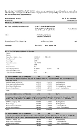
1. Records Checked Through: May 30, 2013 @ 4:00 p.m.
Prepared By: Holland Services
PROPERTY DESCRIPTION
Tax Parcel Number(s) Covered by Lease:
Union District
API #
Lessor's Source of Title Volume/Page See Title Notes Below 409
Containing 409.000000 acres, more or less.
Lessor:
Lessee:
Lease Date / Effective Date: 3/20/1951 / 3/20/1951
Date Recorded:
Book/Page:
Lease Gross Acres
Term:
Expiration Date:
Lease Royalty Interest: 0.125000 Fraction: 1/8
Lease Special Provisions:
Top Lease Date / Book/Page N/A / N/A
OIL AND GAS LEASEHOLD OWNERSHIP GWI NRI TYPE
Cardinal Natural Fuel Co. Inc. 0.666670 0.546878 Working Interest
Great American Exploration, Inc. 0.333333 0.273435 Working Interest
Hope Natural Gas Company 0.000000 0.054688 Overriding Royalty Interest
Lessor's Royalty Interest 0.000000 0.125000 Lessor's Royalty Interest
Total 1.000000 1.000000
OIL AND GAS LEASEHOLD OWNERSHIP GWI NRI TYPE
CNX Gas Company, LLC 0.500000 0.410156 Working Interest
Noble Energy 0.500000 0.410156 Working Interest
Hope Natural Gas Company 0.000000 0.054688 Overriding Royalty
Lessor's Royalty Interest 0.000000 0.125000 Lessor's Royalty Interest
Total 1.000000 1.0000000
OIL AND GAS LEASEHOLD OWNERSHIP GWI NRI TYPE
CNX Gas Company, LLC 1.000000 0.820312 Working Interest
Hope Natural Gas Company 0.000000 0.054688 Overriding Royalty
Lessor's Royalty Interest 0.000000 0.125000 Lessor's Royalty Interest
Total 1.000000 1.000000
As to all depths and formations from the surface to the stratigraphic equivalent of the top of the Burkett in the DEPI #14815
(API 47-001-02850) at 7350'MD and from the stratigraphic equivalent of the top of the Onondaga at 7710'MD.
5/7/1952
N/A
As to 100 acres of a line running due West from the Northeast corner of 112 acre tract down to 100 ' below the base of the
Fifth Sand Horizon
28/55
409.000000
HBP
N/A
As to depths within the Marcellus Formation, being from the stratigraphic equivalent of the top of the Burkett in the DEPI
#14815 (API 47-001-02850) at 7350'MD through the stratigraphic equivalent of the top of the Onondaga at 7710'MD.
The following OWNERSHIP SUMMARY REPORT is based on a cursory check of the records located in the county offices
where the subject property is located. The examiner and preparer assume no responsibility as to legal matters in character
and incorrectly indexed or missing documents.
05-8E-37, 05-8E-45, 05-8E-45.1, 05-
9E-6, 05-9E-6.1, 05-9E-6.2, 05-9E-
6.3, 05-9E-6.4, 05-9E-7, 05-9E-7.1
4709701730; 4709701566;
4709700661; 4709701037
EFFECTIVE OIL AND GAS LEASE SUMMARY
2. 2 of 3
TITLE NOTES
1. Lessor, Benton C. Radabaugh, obtained interest in the acreage through several deeds as follows: DB 30/519, DB 40/464, DB
46/72, DB 46/73, DB 46/352, DB 47/285, DB 49/54, DB 53/5, DB 53/6, DB 53/345, DB 61/464, DB 61/497, DB 100/476, DB
102/420, DB 118/7, DB 118/8, DB 118/9, DB 118/10, DB 133/319, DB 133/321, DB 133/323, DB 133/325, DB 133/327, DB
133/330, DB 133/365.
2. Hope Natural Gas Company reserves a 1/16 ORRI in AB 4/266 when assigning the Leasehold. In the next conveyance in the
chain, Hope Natural Gas receives back the Leasehold minus 100 acres. For the purposes of calculating the NRI, I have continued on
as Hope still receiving the ORRI even though they owned the interest at that time.