1. Field Book
for Describing and
Sampling Soils
Version 3.0
National Soil Survey Center
Natural Resources Conservation Service
U.S. Department of Agriculture
September 2012
2.
3. ACKNOWLEDGMENTS
The science and knowledge in this document are distilled from the
collective experience of thousands of dedicated soil scientists during
the more than 100 years of the National Cooperative Soil Survey
(NCSS) program. A special thanks is due to these largely unknown
stewards of the natural resources of this nation.
Special thanks and recognition are extended to those who
contributed extensively to the preparation and production of this
book: the soil scientists from the NRCS and NCSS cooperators
who reviewed and improved it; Tammy Umholtz for document
preparation and graphics; and the NRCS Soil Science Division for
funding it.
Proper citation for this document is:
Schoeneberger, P.J., D.A. Wysocki, E.C. Benham, and Soil
Survey Staff. 2012. Field book for describing and sampling soils,
Version 3.0. Natural Resources Conservation Service, National
Soil Survey Center, Lincoln, NE.
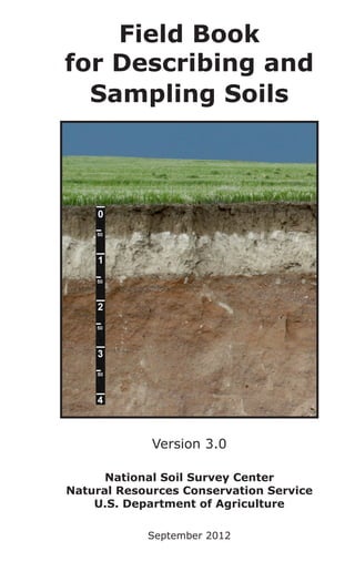
Cover Photo: A polygenetic Calcidic Argiustoll with an A, Bt, Bk,
2BC, 2C horizon sequence. This soil formed in Peoria Loess that
blankets the fluvial Ash Hollow Formation of the Ogallala Group. It
occurs in an undulating area of the Cheyenne Tablelands in northern
Banner County, Nebraska. The scale is in meters. (Photo by Doug
Wysocki, NRCS, Lincoln, NE, June 2011.)
Trade names are used solely to provide specific information. Mention of
a trade name does not constitute a guarantee of the product by the U.S.
Department of Agriculture nor does it imply endorsement by the Department
or the Natural Resources Conservation Service over comparable products that
are not named.
The U.S. Department of Agriculture (USDA) prohibits discrimination in
all its programs and activities on the basis of race, color, national origin,
age, disability, and where applicable, sex (including gender identity and
expression), marital status, familial status, parental status, religion, sexual
orientation, political beliefs, genetic information, reprisal, or because all or
part of an individual’s income is derived from any public assistance program.
(Not all prohibited bases apply to all programs.) Persons with disabilities who
require alternative means for communication of program information (Braille,
large print, audiotape, etc.) should contact USDA’s TARGET Center at (202)
720-2600 (voice and TDD). To file a complaint of discrimination, write to:
USDA, Assistant Secretary for Civil Rights, Office of the Assistant Secretary for
Civil Rights, 1400 Independence Avenue, S.W., Stop 9410, Washington, D.C.
20250-9410, or call toll-free at (866) 632-9992 (English) or (800) 877-8339
(TDD) or (866) 377-8642 (English Federal-relay) or (800) 845-6136 (Spanish
Federal-relay). USDA is an equal opportunity provider and employer.
USDA-NRCS
i
September 2012
4. FOREWORD
Purpose: The following instructions, definitions, concepts, and
codes are a field guide for making or reading soil descriptions
and sampling soils as presently practiced in the USA. (Note:
References cited in the Foreword are listed at the end of
Chapter 1 [p. 1–31].)
Background: Soil description methodology was developed by soil
scientists throughout the entire course of the soil survey. The
USDA published small instruction booklets for field parties,
including soil descriptions, in 1902–1904, 1906, and 1914. The
first USDA guide for soil horizon identification and description
was released in 1937 (Bureau of Chemistry and Soils, 1937).
Dr. Roy Simonson and others later summarized and revised this
information (Soil Survey Staff, 1951; Soil Survey Staff, 1962).
Brief “color-book” inserts with shorthand notation were released
by the Soil Conservation Service (Spartanburg, SC, 1961;
Western Technical Center, Portland, OR, 1974). Previous Field
Books were released in 1998 (Schoeneberger et al.) and 2002
(Schoeneberger et al.). This is an updated Field Book version
that summarizes current knowledge, includes updates since
2002, and reflects changes in source documents.
Standards: This Field Book summarizes and updates current
National Cooperative Soil Survey conventions for describing soils
(Soil Survey Manual [Soil Survey Division Staff, 1993]; National
Soil Survey Handbook [Soil Survey Staff, 2012d]; National Soil
Information System (NASIS), release 6.2 [Soil Survey Staff,
2012c]; and NASIS Data Dictionary [Soil Survey Staff, 2012a]).
Some content is an abbreviation of primary sources.
Regarding Pedon PC and NASIS: The Field Book is a current,
practical soil description guide for the soil science community. It
is not a guide on “How To Use Pedon PC or NASIS.” Differences
and linkages between soil science conventions, Pedon PC,
NASIS, and older systems are shown, where reasonable to do
so, as an aid for interpreting and converting archived data.
Standard procedures and terms for describing soils have
changed and increased in recent years (e.g., redoximorphic
features). Coincident with these changes has been the
development and use of computer databases to store soil
descriptions and associated information. The nature of
databases, for better or worse, requires consistent and “correct”
use of terms.
Sources: This Field Book draws from several primary sources: The
Soil Survey Manual (Soil Survey Division Staff, 1993) and the
National Soil Survey Handbook (NSSH), Parts 618 and 629 (Soil
USDA-NRCS ii
September 2012
5. Survey Staff, 2012d). Other important sources are footnoted
throughout to give appropriate credit and encourage in-depth
information review. Other material is unique to this book.
Brevity: In a field book, brevity is efficiency. Despite this book’s
apparent length, the criteria, definitions, and concepts are
condensed. We urge users to review the comprehensive
information in original sources to avoid errors resulting from our
brevity.
Measurement Units: For soil description, metric units are the
scientific standard. Both NASIS and Pedon PC use metric units.
Format: The “Site Description” and “Profile Description” sections
generally follow conventional profile description format and
sequence (e.g., SCS-Form 232, December 1984). Some
descriptors are arranged in a sequence more compatible
with field description rather than data entry (e.g., Horizon
Boundary is next to Horizon Depth, rather than at the end).
The sequence followed differs somewhat from and does not
supersede convention for writing formal soil descriptions in soil
survey reports or Official Soil Series Descriptions (e.g., National
Soil Survey Handbook, Part 614; Soil Survey Staff, 2012d).
Codes: Shorthand notation is listed in the Code column for some
descriptors. Long-standing conventional codes are retained
because of widespread recognition. Some recent codes have
been changed to make them more logical. Some data elements
have different codes in various systems (e.g., conventional
[Conv.] vs. NASIS vs. Pedon PC), and several columns may
be shown to facilitate conversions. If only one code column is
shown, it can be assumed that the conventional, NASIS, and
Pedon PC codes are all the same.
Standard Terms vs. Creativity: Describe and record what you
observe. Choice lists in this document are a minimal set of
descriptors. Use additional descriptors, notes, and sketches to
record pertinent information and/or features if no data element
or choice list entry exists. Record such information as free-hand
notes under Miscellaneous Field Notes.
Changes: Soil science is an evolving field. Changes to this
Field Book should and will occur. Please send comments or
suggestions to the Director, National Soil Survey Center, USDANRCS; 100 Centennial Mall North, Rm. 152; Lincoln, NE 685083866.
USDA-NRCS iii
September 2012
13. SITE DESCRIPTION
P.J. Schoeneberger, D.A. Wysocki, and E.C. Benham, NRCS, Lincoln, NE
DESCRIBER NAME(S)
NAME (or initials)—Record the observer(s) making the description;
e.g., Erling E. Gamble or EEG.
DATE
MONTH/DAY/YEAR—Record the observation date. Use numeric
notation (MM/DD/YYYY); e.g., 05/21/2012 (for May 21, 2012).
CLIMATE
Document the prevailing weather conditions at time of observation
(a site condition that affects some field methods; e.g., Ksat). Record
the major Weather Conditions and Air Temperature; e.g., Rain,
27 °C.
Weather Conditions
sunny/clear
Code
SU
partly cloudy
PC
overcast
OV
rain
RA
sleet
SL
snow
SN
AIR TEMPERATURE—Ambient air temperature at chest height
(Celsius or Fahrenheit); e.g., 27 °C.
SOIL TEMPERATURE—Record the ambient Soil Temperature
and Depth at which it is determined; e.g., 22 °C, 50 cm. (NOTE:
Soil taxonomy generally requires a 50 cm depth.) Soil temperature
should only be determined from a freshly excavated surface that
reflects the ambient soil conditions. Avoid surfaces equilibrated with
air temperatures.
Soil Temperature—Record soil temperature (in °C or °F).
Soil Temperature Depth—Record depth at which the ambient
soil temperature is measured; e.g., 50 cm.
USDA-NRCS 1–1
September 2012
14. LOCATION
Record precisely the point or site location (e.g., coordinates).
Latitude and longitude as measured with a Global Positioning
System (GPS) is the preferred descriptor. Report lat. and long. as
degrees, minutes, seconds, and decimal seconds with direction, or
as degrees and decimal degrees with direction. For example:
LATITUDE—46° 10' 19.38" N. or 46°.17205 N
LONGITUDE—95° 23' 47.16" W. or 95°.39643 W
GEODETIC DATUM (Horizontal_datum_name in NASIS)—A
geodetic datum must accompany latitude and longitude. A geodetic
datum is a model that defines the earth’s shape and size and serves
as a latitude, longitude reference. Geodetic datum is a selectable
GPS parameter. The preferred datum is the World Geodetic
System 1984 (WGS-84). See “Location Section” for the complete
geodetic datum list (p. 6–1).
Topographic maps display latitude and longitude and the geodetic
datum employed (e.g., NAD 27, NAD 83). NOTE: NASIS requires
latitude and longitude but allows other coordinate or location
descriptors (e.g., UTM, State Plane Coordinates, Public Land Survey,
Metes and Bounds). See “Location Section” (p. 6–1) for details.
TOPOGRAPHIC QUADRANGLE
Record the topographic map name (USGS quadrangle) that covers
the observation site. Include scale (or “series”) and year printed;
e.g., Pollard Creek-NW; TX; 1:24,000; 1972.
SOIL SURVEY SITE IDENTIFICATION NUMBER (SITE
ID)
An identification number must be assigned if samples are collected
(called User_Pedon_ID in NASIS). For the Kellogg Soil Survey
Laboratory (Soil Survey Staff, 2011), this identifier consists of five
required and one optional item.
Example: S2004WA27009
1) S indicates a sampled pedon. (“S” is omitted for pedons
described but not sampled.)
2) 2004=calendar year sampled. Use 4-digit format; e.g.,
2012.
3) WA=two-character (alphabetic) Federal Information
Processing Standards (FIPS 6-4) code for the state where
sampled. For non-U.S. sites, use the Country Code from ISO
USDA-NRCS 1–2
September 2012
15. 3166-1 (International Organization for Standards, 2012b);
e.g., CA for Canada.
4) 027=3-digit (numeric) FIPS code for county where
sampled. For non-U.S. sites, use the appropriate two- or
three-letter Administrative Subdivision code from ISO
3166-2 (International Organization for Standards, 2012b)
preceded by a 0 (zero) for two-letter codes; e.g., 0SK for
Saskatchewan.
5) 009=consecutive pedon number for calendar year for
county. This should be a 3-digit number. Use 0s (zeros) as
placeholders when necessary; e.g., 9 becomes 009.
6) (Optional) A one-character “satellite” code can be used, if
needed, to indicate a relationship between a primary pedon
and satellite sample points; e.g., A in S2004WA027009A.
NOTE: Do not use spaces, dashes, or hypens (for database
reasons). Use uppercase letters. A complete example is
S2011OK061005A. A sampled soil characterization pedon collected
in 2011 (2011) from Oklahoma (OK), Haskell County (061); this is
a satellite pedon (A) of the fifth pedon (005) sampled in that county
during 2011.
COUNTY FIPS CODE
The Federal Information Processing Standards (FIPS) code is a
3-digit number for a county within a state in the U.S. (National
Institute of Standards and Technology, 1990). Record the FIPS code
for the county where the pedon or site occurs; e.g., 061 (Haskell
County, OK). For non-U.S. sites, use the appropriate two- or threecharacter Country Code (International Organization for Standards–
Country Codes ISO 3166-1; 2012a or current date).
MLRA
This 1- to 3-digit number, often including one alpha character,
identifies the Major Land Resource Area (NRCS, 2006); e.g., 58C
(Northern Rolling High Plains, Northeastern Part).
TRANSECTS
If a soil description is one of multiple transect points, record
transect information; e.g., Transect ID, Stop Number, Interval,
GPS Coordinates. NASIS also accommodates Transect Kind
(random point [–R], regular interval [–I]), Transect Section
Method (biased [–B], random [–R]), Delineation Size (acres),
Transect Direction (azimuth heading, e.g., 180°).
USDA-NRCS 1–3
September 2012
16. TRANSECT ID—A 4- or 5-digit number that identifies the transect;
e.g., 0010 (the tenth transect within the survey area).
STOP NUMBER—If the sample/pedon is part of a transect, enter
the 2-digit stop number along the transect; e.g., 07. (NOTE: NASIS
allows up to 13 characters.)
INTERVAL—Record distance between observation points, compass
bearing, and GPS coordinates, or draw a route map in the Field
Notes (“User Defined Section”).
SERIES OR COMPONENT NAME
Assign the appropriate Soil Series or Map Unit Component name
at time of description (e.g., Cecil). If unknown, enter SND for
“Series Not Designated.” (In NASIS, “SND” is not used; assign an
appropriate soil taxonomy class; e.g., Udorthents.) NOTE: A fieldassigned series name may change after additional data collection
and lab analyses.
MAP UNIT SYMBOL—Record the soil map unit symbol (if known)
for the sample site.
PHOTO #—If aerial imagery is used, record the photograph number
that covers the sample site.
GEOMORPHIC INFORMATION
See the “Geomorphic Description Section” for complete lists
(p. 3–1). Codes follow each listed choice. Conventionally, the
entire name (e.g., mountains) is recorded.
PART 1: PHYSIOGRAPHIC LOCATION
Physiographic Division—e.g., Interior Plains or IN
Physiographic Province—e.g., Central Lowland or CL
Physiographic Section—e.g., Wisconsin Driftless Section or
WDS
State Physiographic Area (Opt.)—e.g., Wisconsin Dells
Local Physiographic/Geographic Name (Opt.)—e.g., Bob’s
Ridge
PART 2: GEOMORPHIC DESCRIPTION
Landscape—e.g., Foothills or FH
Landform—e.g., Ridge or RI
Microfeature—e.g., Mound or MO
Anthropogenic Feature—e.g., sanitary landfill or SL
USDA-NRCS 1–4
September 2012
17. PART 3: SURFACE MORPHOMETRY
Elevation—The height of a point on the earth’s surface relative
to Mean Tide Level (MTL), formerly Mean Sea Level (MSL).
Record units; e.g., 106 m or 348 ft. Recommended methods:
interpolation from topographic map contours; altimeter reading
tied to a known elevation datum. NOTE: An elevation value
from a GPS can be recorded. Since the GPS elevation value
typically is less certain than the latitude and longitude values,
a correction for quantifiable errors is important (e.g., WAAS,
or averaging many elevation values at a point by collecting
a track log at the point and averaging the elevation values).
The latitude and longitude coordinates can be used to extract
an elevation value from a DEM, if available. Note that all parts
of a DEM cell return the same elevation value, so a higher
resolution DEM is important for accuracy, especially if the point
is on a steep slope.
Slope Aspect—The compass direction (in degrees and
accounting for declination) that a slope faces, viewed
downslope; e.g., 225°.
Slope Gradient—The ground surface inclination with respect
to the horizontal plane; commonly called “slope.” Make
observations downslope to avoid errors from clinometer types;
e.g., 18%.
Slope Complexity—Describe the relative ground surface
uniformity (smooth linear or curvilinear=simple or S) or
irregularity (complex or C) downslope through the site; e.g.,
simple or S.
USDA-NRCS 1–5
September 2012
18. Simple vs. Complex
(adapted from Wysocki et al., 2000)
Relative Slope Segment Position (called geomorph_
slope_segment in NASIS)—If useful to subdivide long slopes,
describe relative slope location of the area or point of interest.
Relative Slope
Segment Position
Code
Criteria
lower third
LT
on lower third of slope
middle third
MT
on middle third of slope
upper third
UT
on upper third of slope
Slope Shape—Slope shape is described in two directions: up
and down slope (perpendicular to the elevation contour) and
across slope (along the elevation contour); e.g., Linear, Convex
or LV.
LL
LV
LC
VL
VV
VC
CL
CV
CC
L = Linear; V = Convex; C = Concave
Surface flow pathway
(adapted from Wysocki et al., 2000)
USDA-NRCS 1–6
September 2012
19. Hillslope-Profile Position (commonly called Hillslope
Position)—Two-dimensional geomorphic descriptors that are
segments (i.e., slope position) along a line that runs up and
down slope; e.g., backslope or BS. This is best applied to
points, not areas (e.g., map units).
Position
Code
summit
SU
shoulder
SH
backslope
BS
footslope
SU
FS
toeslope
TS
SH
SH
SU
BS
BS
FS
Channel
TS
TS
FS
Alluvium
(adapted from Ruhe, 1975)
USDA-NRCS 1–7
September 2012
20. Geomorphic Component—Three-dimensional geomorphic
descriptors for landforms, landform portions, or microfeatures
that are applied to areas. Unique 3D descriptors are defined
for Hills, Terraces and Stepped Landforms, Mountains, and Flat
Plains; e.g., Hills-nose slope, or NS.
Hills
NASIS Code
interfluve
IF
crest
CT
head slope
HS
nose slope
NS
side slope
SS
free face
FF
base slope
BS
free face (i.e., rock outcrop)
u
fl
te
r
am
op
e
sl
se
er
er
Lo w
Alluvial
fill
Higher
str
e
no
sl se
op
e
o rd
in
s
sl ide
op
e
ol
lu
C
e
op
sl
ba
se
ba
m
viu
and
st
sl
op
ea
llu
viu
m
e
cr
ve
he
slo ad
pe
order st
ream
(Wysocki et al., 2012)
Terraces and Stepped Landforms
Code
riser
RI
tread
TR
USDA-NRCS 1–8
September 2012
21. Uplands
Terraces
Flood-Plain Steps
Annual
Flood
Plain
100 yr. Flood Zone
TREAD
RISER
(adapted from Wysocki et al., 2000)
Mountains
Code
mountaintop
MT
mountainflank
MF
upper third—mountainflank
UT
center third—mountainflank
CT
lower third—mountainflank
LT
free face
FF
mountainbase
MB
USDA-NRCS 1–9
September 2012
22. Flat Plains
dip
Code
DP
rise
RI
talf
TF
Microrelief—Small, relative elevation differences between
adjacent areas on the earth’s surface; e.g., microhigh or MH or
microlow or ML.
Microrelief
microhigh
Code
MH
microlow
ML
microslope
MS
Drainage Pattern—The interconnected system of drainage
channels on the land surface; also called drainage network.
(See graphics, p. 3–45.) Can be recorded as a Text Note.
Drainage Pattern
Code
annular
AN
artificial
AR
centripetal
CE
dendritic
DN
deranged
DR
karst
KA
parallel
PA
pinnate
PI
radial
RA
USDA-NRCS 1–10
September 2012
23. Drainage Pattern
Code
rectangular
RE
thermokarst
TH
trellis
TR
WATER STATUS
DRAINAGE—An estimate of the natural drainage class (i.e., the
prevailing wetness conditions) of a soil; e.g., somewhat poorly
drained or SP.
Drainage Class
Subaqueous Drainage
Conv. Code
SA
Very Poorly Drained
VP
Poorly Drained
PD
Somewhat Poorly Drained
SP
Moderately Well Drained
MW
Well Drained
WD
Somewhat Excessively Drained
SE
Excessively Drained
ED
The following definitions are from the traditional, national criteria
for natural soil drainage classes (Soil Survey Division Staff, 1993).
Specific regional definitions and criteria exist. (Contact an NRCS
State office for specific local criteria.)
Subaqeous Drainage—Free water is above the soil surface.
The occurrence of internal free water is permanent, and there
is a positive water potential at the soil surface for more than
21 hours each day. The soils have a peraquic soil moisture
regime (proposed 2010; Soil Survey Staff revision online at
soils.usda.gov/technical/manual/proposedchanges.html).
Very Poorly Drained—Water is at or near the soil surface
during much of the growing season. Internal free water is
very shallow and persistent or permanent. Unless the soil is
artificially drained, most mesophytic crops cannot be grown.
Commonly, the soil occupies a depression or is level. If rainfall
is persistent or high, the soil can be sloping.
Poorly Drained—The soil is wet at shallow depths periodically
during the growing season or remains wet for long periods.
Internal free water is shallow or very shallow and common
or persistent. Unless the soil is artificially drained, most
mesophytic crops cannot be grown. The soil, however, is not
USDA-NRCS 1–11
September 2012
24. continuously wet directly below plow depth. The water table is
commonly the result of a low or very low saturated hydraulic
conductivity class or persistent rainfall or a combination of
these factors.
Somewhat Poorly Drained—The soil is wet at a shallow
depth for significant periods during the growing season.
Internal free water is commonly shallow or moderately deep
and transitory or permanent. Unless the soil is artificially
drained, the growth of most mesophytic plants is markedly
restricted. The soil commonly has a low or very low saturated
hydraulic conductivity class or a high water table, receives
water from lateral flow or persistent rainfall, or is affected by
some combination of these factors.
Moderately Well Drained—Water is removed from the soil
somewhat slowly during some periods of the year. Internal free
water commonly is moderately deep and may be transitory
or permanent. The soil is wet for only a short time within
the rooting depth during the growing season but is wet long
enough that most mesophytic crops are affected. The soil
commonly has a moderately low or lower saturated hydraulic
conductivity class within 1 meter of the surface, periodically
receives high rainfall, or both.
Well Drained—Water is removed from the soil readily but not
rapidly. Internal free water commonly is deep or very deep;
annual duration is not specified. Water is available to plants in
humid regions during much of the growing season. Wetness
does not inhibit growth of roots for significant periods during
most growing seasons.
Somewhat Excessively Drained—Water is removed from the
soil rapidly. Internal free water commonly is very deep or very
rare. The soils are commonly coarse textured and have high
saturated hydraulic conductivity or are very shallow.
Excessively Drained—Water is removed from the soil very
rapidly. Internal free water commonly is very deep or very
rare. The soils are commonly coarse textured and have very
high saturated hydraulic conductivity or are very shallow.
USDA-NRCS 1–12
September 2012
25. FLOODING—Estimate the Frequency, Duration, and Months
that flooding is expected; e.g., rare, brief, Jan.-March.
Frequency—Estimate how often, typically, flooding occurs.
Frequency
Class
Criteria: estimated average
number of flood events per
time span 1
Code
None
NO
No reasonable chance
(e.g., <1 time in 500 years)
Very Rare
VR
≥1 time in 500 years, but
<1 time in 100 years
Rare
RA
1 to 5 times in 100 years
2
OC
>5 to 50 times in 100 years
2, 3
FR
>50 times in 100 years
VF
>50% of all months in year
Occasional
Frequent
Very Frequent
3, 4
1
Flooding Frequency is an estimate of the current condition,
whether natural or human influenced (such as by dams or
artificial levees).
2
Historically, Occasional and Frequent classes could be combined
and called Common; not recommended.
3
Very Frequent class takes precedence over Frequent, if
applicable.
4
The Very Frequent class is intended for tidal flooding.
Duration—Estimate how long an area typically is flooded
during a single flood event.
Duration Class
Code
Conv.
Criteria: estimated
average duration per
flood event
NASIS
Extremely Brief
EB
EB
0.1 to < 4 hours
Very Brief
VB
VB
4 to < 48 hours
Brief
BR
B
2 to < 7 days
Long
LO
L
7 to < 30 days
Very Long
VL
VL
≥ 30 days
Months—Estimate the beginning and ending month(s) in a
year that flooding generally occurs; e.g., Dec.-Feb.
USDA-NRCS 1–13
September 2012
26. PONDING—Estimate or monitor the Frequency, Depth, and
Duration of standing water. A complete example is: occasional,
50 cm, brief, Feb.-Apr.
Frequency—Estimate how often, typically, ponding occurs.
Frequency
Class
Criteria: estimated, average # of
ponding events per time span
Code
None
NO
<1 time in 100 years
Rare
RA
1 to 5 times in 100 years
Occasional
OC
>5 to 50 times in 100 years
Frequent
FR
>50 times in 100 years
Depth—Estimate the average, representative depth of ponded
water at the observation site and specify units; e.g., 1 ft or
30 cm.
Duration—Estimate how long, typically, the ponding lasts.
Duration
Class
Code
Criteria: estimated, average
time per ponding event
Conv.
NASIS
Very Brief
VB
VB
Brief
BR
B
2 to <7 days
Long
LO
L
7 to <30 days
Very Long
VL
VL
<2 days
≥30 days
(SOIL) WATER STATE (called Observed Soil Moisture Status
in NASIS.)—Estimate the water state of the soil at the time of
observation; e.g., wet, nonsatiated. Soil temperature must be
above 0 °C. (Does not apply to frozen soil.)
USDA-NRCS 1–14
September 2012
27. Water
State
Class
Dry
Code
Conv.
D
Wet
Wet:
Satiated
Traditional Criteria:
tension and field
2
5
5
>1500 kPa
>15 bars of tension
(=1500 kPa)
≤1500 kPa
to
>1.0 kPa
(or
>0.5 kPa) 3
Former Usage: >1/3
to 15 bars of tension
(33 to 1500 kPa) (field
capacity to wilting
point)
W
1
Wet:
Nonsatiated
D
Criteria:
tension
M
1
Moist
NASIS
≤1.0 kPa
(or
<0.5 kPa)
0-1/3 bar tension
(<33 kPa)
(field capacity or
wetter)
M
4
>0.00 and
≤1.0 kPa
(or
<0.5 kPa) 3
WN
WS
3
W
No Free Water:
Water films are
visible; sand grains
and peds glisten,
but no free water is
present
≤0.00 kPa
Free Water:
Free water easily
visible
1
Additional subclasses of water state can be recognized for Dry
and Moist classes, if desired (Soil Survey Division Staff, 1993,
p. 91).
2
Convention assumes 15 bars of tension as the wilting point for
most annual agricultural row crops. Caution: Various perennials,
shrubs, trees, and other native vegetation have a wilting point of
as much as 66 bars tension (=6600 kPa) or more.
3
Use the 1 kPa limit for all textures, except those coarser than
loamy fine sand (which use 0.5 kPa limit; Soil Survey Division
Staff, 1993, p. 90).
4
NASIS uses the same three class names (Dry, Moist, Wet) but
lumps the “wet: nonsatiated” subclass with the Moist class.
5
Satiation vs. Saturation: Satiation implies minor amounts of
entrapped air in the smallest pores. True saturation implies no
entrapped air. In Soil Taxonomy, “Saturation is ... zero or positive
pressure in the soil ...” (Soil Survey Staff, 2010). Satiation, for
practical purposes, is ≈ saturation. Temporal monitoring of a
water table by piezometer or other accepted methods may be
needed to verify saturation. Related terms used for classifying
soils (i.e., soil taxonomy): Endosaturation is saturation in all
USDA-NRCS 1–15
September 2012
28. layers to >200 cm (80 inches). Episaturation requires saturated
layers that overlie unsaturated layers within the upper 2 m
(80 inches). Anthric saturation, a variant of episaturation, is
saturation due to management-induced flooding (e.g., for rice or
cranberry production).
LAND COVER
LAND COVER (called EARTH COVER - KIND in NASIS)—Record
the dominant land cover at the site; e.g., intermixed hardwoods and
conifers.
Kind
1
Code
Kind
Code
1
ARTIFICIAL COVER (A)—Nonvegetative cover; due to
human activity.
rural transportation roads, railroads
RU
urban and built-up cities, farmsteads,
industry
UR
BARREN LAND (B)—<5% vegetative cover naturally or
from construction.
culturally induced saline seeps, mines,
quarries, and oil-waste
areas
CI
other barren - salt flats,
mudflats, slickspots,
badlands
permanent snow or ice
PS
rock
RK
sand or gravel
SG
OB
CROP COVER (C)—includes entire cropping cycle (land
prep, crop, or crop residue) for annual or perennial
herbaceous plants.
close-grown crop wheat, rice, oats, and
rye; small grains
CG
row crop - corn, cotton,
soybeans, tomatoes,
and other truck crops,
tulips
RC
GRASS/HERBACEOUS COVER (G)—>50% grass, grasslike
(sedges/rushes), or forb cover, mosses, lichens, ferns;
nonwoody.
hayland - alfalfa,
fescue, bromegrass,
timothy
HL
rangeland, savanna 10 to 20% tree cover
RS
marshland - grasses
and grasslike plants
ML
rangeland, shrubby 20 to 50% shrub cover
RH
USDA-NRCS 1–16
September 2012
29. Kind
1
Code
Kind
Code
1
pastureland, tame fescues, bromegrass,
timothy, lespedeza
PL
rangeland, tundra
RT
rangeland, grassland;
<10% trees, <20%
shrubs; rangeland used
for hayland
RG
other grass and
herbaceous cover
OH
SHRUB COVER (S)—>50% shrub or vine canopy cover.
crop shrubs - filberts,
blueberry, ornamental
nusery stock
crop vines - grapes,
blackberries, raspberries
CS
native shrubs - shrub
live oak, mesquite,
sagebrush, creosote
bush; rangeland >50%
shrub cover
NS
CV
other shrub cover
OS
TREE COVER (T)—>25% canopy cover by woody plants,
natural or planted.
conifers - spruce, pine,
fir
CO
swamp - trees, shrubs
SW
crop, trees - nuts, fruit,
nursery, Christmas trees
CR
tropical - mangrove and
royal palms
TR
hardwoods - oak,
hickory, elm, aspen
HW
other tree cover
OC
intermixed hardwoods
and conifers - oak-pine
mix
IM
WATER (W)—water at the soil surface; includes seasonally
frozen water.
1
Land Cover Kinds are presented at two levels of detail: Bolded
table subheadings are the “NASIS - Level 1” choices (NSSH,
Part 622.16; Soil Survey Staff, 2012d). Individual choices under
the subheadings are the “NASIS - Level 2” choices.
VEGETATION
PLANT SYMBOL—Record the codes (scientific plant name
abbreviations) for the major plant species found at the site (NRCS,
2012); e.g., ANGE (Andropogon gerardii or big bluestem). (NOTE:
The combination of plant symbol and common name are the
primary plant data element in NASIS.)
USDA-NRCS 1–17
September 2012
30. PLANT COMMON NAME—Record the common names of the major
plant species found at the site (NRCS, 2012); e.g., cottonwood, big
bluestem. This item may be recorded as a secondary data element
to augment the Plant Symbol. CAUTION: Multiple common names
exist for some plants; not all common names for a given plant are
in the national PLANTS database.
PLANT SCIENTIFIC NAME—Record the scientific plant name
along with or in lieu of common names; e.g., Acer rubrum (red
maple). (NOTE: Although used in the past, scientific names of
plants [NRCS, 2012] are not presently recorded by the NRCS.)
(NOTE: NASIS codes for common plant names are derived from the
scientific names.)
VEGETATION COVER—Estimate the percent of the ground covered
by each plant species recorded at the site.
PARENT MATERIAL
Describe the nature of the unconsolidated material (regolith) in
which the soil is formed. If the soil is derived directly from the
underlying bedrock (e.g., granite), identify the Parent Material as
either grus, saprolite, or residuum and then record the appropriate
Bedrock - Kind choice. (NOTE: NASIS uses “Component Parent
Material Origin” to convey the source from which a Parent Material
is derived, predominantly Bedrock - Kind.) Multiple parent
materials, if present, should be denoted; e.g., loess, over colluvium,
over residuum. Use numerical prefixes in the Horizon designations
to denote different parent materials (lithologic discontinuities); e.g.,
A, BE, 2Bt, 2BC, 3C; Peoria Loess, or Calvert Formation.
KIND—e.g., saprolite, loess, colluvium.
Kind
1
Code
Kind
Code
1
EOLIAN DEPOSITS (nonvolcanic)
eolian deposit
EOD
loess, calcareous
CLO
eolian sands
EOS
loess, noncalcareous
NLO
loess
LOE
parna
PAR
GLACIAL and PERIGLACIAL DEPOSITS
cryoturbate
CRY
till, ablation
ATI
drift
GDR
till, basal
BTI
glaciofluvial deposit
GFD
till, flow
FTI
glaciolacustrine deposit
GLD
till, lodgment
LTI
glaciomarine deposit
GMD
till, melt-out
MTI
USDA-NRCS 1–18
September 2012
31. Code
Kind
outwash
OTW
till, subglacial
GTI
solifluction deposit
SOD
till, supraglacial
UTI
supraglacial debris-flow
SGF
till, supraglacial
meltout
PTI
till
TIL
Kind
1
Code
1
IN-PLACE DEPOSITS (nontransported)
bauxite
grus
BAU
GRU
2
residuum
saprolite
MASS MOVEMENT DEPOSITS
table)
3
RES
2
SAP
2
(See Mass Movement Types
MISCELLANEOUS MASS MOVEMENT DEPOSITS
colluvium
COL
slump block
scree
SCR
SLB
talus
TAL
MASS MOVEMENT DEPOSIT (Unspecified Landslide)
MMD
COMPLEX LANDSLIDE DEPOSITS
CLD
FALL DEPOSITS
FAD
debris fall deposit
DLD
rock fall deposit
soil fall deposit
(=earth fall)
SFD
RFD
FLOW DEPOSITS
FLD
EFD
debris avalanche
deposit
creep deposit
CRP
debris flow deposit
DFD
mudflow deposit
MFD
debris slide deposit
DSD
sand flow deposit
SAD
lahar
LAH
solifluction deposit
SOD
rockfall avalanche
deposit
RAD
earthflow deposit
SLIDE DEPOSITS
debris slide deposit
DAD
SD
OSD
4
Translational Slide
deposit
Rotational Slide deposit
RLD
rotational debris slide
deposit
RDD
translational debris
slide deposits
TDD
rotational earth slide
deposit
RED
translational earth
slide deposit
TED
USDA-NRCS 1–19
TSD
September 2012
33. Kind
1
Code
Kind
Code
1
tephra (all ejecta)
TEP
WATERLAID (or TRANSPORTED) DEPOSITS
alluvium
ALL
lagoonal deposits
LGD
backswamp deposit
BSD
marine deposit
MAD
beach sand
BES
marl
MAR
coprogenic materials
COM
marl, coastal
CMA
diatomaceous earth
DIE
marl, freshwater
FWM
estuarine deposit
ESD
overbank deposit
OBD
fluviomarine deposit
FMD
pedisediment
PED
greensands
GRS
slope alluvium
SAL
lacustrine deposit
LAD
valley side alluvium
VSA
ANTHROPOGENIC DEPOSITS
coal extraction mine
spoil
CES
metal ore extraction
mine spoil
MES
dredge spoils
DGD
mine spoil or earthy fill
MSE
human-transported
materials
HTM
1
Parent material definitions are found in the “Glossary of Landform
and Geologic Terms,” NSSH, Part 629 (Soil Survey Staff, 2012b),
or the Glossary of Geology (Neuendorf et al., 2005).
2
Use the most precise term for the in situ material. Residuum is
the most generic term.
3
Cruden and Varnes, 1996.
4
Debris slide is a more general, encompassing term that may be
further subdivided into rotational debris slide or translational
debris slide.
5
These generic terms refer to the dominant origin of the organic
materials or deposits from which the organic soil has formed (i.e.,
parent material) (Soil Survey Division Staff, 1993). These terms
partially overlap with those recognized in soil taxonomy (terms
that refer primarily to what the organic material presently is); see
the “Diagnostic Horizons or Characteristics” table.
6
sg=specific gravity=the ratio of a material’s density to that of
water (weight in air/[weight in air - weight in water]).
USDA-NRCS 1–21
September 2012
34. BEDROCK
Describe the nature of the continuous hard rock underlying the soil.
Specify the Kind, Fracture Interval, Hardness, and Weathering
Class.
KIND—e.g., limestone.
Kind
1
Code
Kind
Code
1
IGNEOUS—INTRUSIVE
anorthosite
ANO
pyroxenite
PYX
diabase
DIA
quartzite
QZT
diorite
DIO
quartz-diorite
QZD
gabbro
GAB
quartz-monzonite
QZM
granite
GRA
syenite
SYE
GRT
syenodiorite
SYD
granodiorite
GRD
tonalite
TON
monzonite
MON
ultramafic rock
peridotite
PER
granitoid
2
2
UMU
IGNEOUS—EXTRUSIVE
aa lava
AAL
pahoehoe lava
PAH
andesite
AND
pillow lava
PIL
BAS
pumice
(flow, coherent)
PUM
block lava
BLL
rhyolite
RHY
dacite
DAC
scoria (coherent mass)
SCO
latite
LAT
tachylite
TAC
obsidian
OBS
trachyte
TRA
ignimbrite
IGN
tuff, welded
TFW
pyroclastics
(consolidated)
PYR
tuff breccia
TBR
pyroclastic flow
PYF
volcanic breccia
VBR
pyroclastic surge
PYS
volcanic breccia, acidic
AVB
tuff
TUF
volcanic breccia, basic
BVB
tuff, acidic
ATU
volcanic sandstone
VST
tuff, basic
BTU
basalt
IGNEOUS—PYROCLASTIC
USDA-NRCS 1–22
September 2012
36. Kind
Code
1
Kind
Code
1
SEDIMENTARY—EVAPORITES, ORGANICS, AND
PRECIPITATES
bauxite
BAU
limestone, coral
COR
chalk
CHA
limestone, phosphatic
PLS
lignite
LIG
limonite
LIM
chert
CHE
novaculite
NOV
coal
COA
rock anhydrite
RAN
diatomite
DIA
rock gypsum
GYP
dolomite (dolostone)
DOL
rock halite
RHL
limestone
LST
travertine
TRV
limestone, arenaceous
ALS
tripoli
TRP
limestone, argillaceous
RLS
tufa
TUA
limestone, cherty
CLS
INTERBEDDED (alternating layers of different sedimentary
lithologies)
limestone-sandstoneshale
LSS
sandstone-shale
SSH
limestone-sandstone
LSA
sandstone-siltstone
SSI
limestone-shale
LSH
shale-siltstone
SHS
limestone-siltstone
LSI
1
Definitions for kinds of bedrock are found in the “Glossary of
Landform and Geologic Terms,” NSSH, Part 629 (Soil Survey
Staff, 2012b), or in the Glossary of Geology (Neuendorf et al.,
2005).
2
Generic term; use only with regional or reconnaissance surveys
(order 3, 4).
FRACTURE INTERVAL CLASS (called Bedrock_fracture_
interval in NASIS)—Describe the dominant (average) horizontal
spacing between vertical joints (geogenic cracks or seams) in the
bedrock layer.
Average Distance
Between Fractures
Code
< 10 cm
1
2
10 to < 45 cm
USDA-NRCS 1–24
September 2012
37. Average Distance
Between Fractures
Code
45 to < 100 cm
3
100 to < 200 cm
4
≥ 200 cm
5
WEATHERING CLASS (called Bedrock_weathering in NASIS)—
The subjective extent to which bedrock has weathered as compared
to its presumed nonweathered state. Record in Notes, if used.
Class
Code
Slight
SL
Moderate
MO
Strong
ST
DEPTH (TO BEDROCK)—Record the depth (cm) from the ground
surface to the contact with coherent (continuous) bedrock.
LITHOSTRATIGRAPHIC UNIT(S)
Record the lithostratigraphic unit(s) of the unconsolidated material
(regolith) and the bedrock in which the soil is formed or from which
it is derived. (This is a text field in NASIS.) For example, Peoria
Loess over pre-Illinoian till over Dakota Formation. (See discussion,
p. 5–12.)
EROSION
Estimate the dominant kind and magnitude of accelerated erosion
at the site. Specify the Kind and Degree.
KIND (called erosion_accelerated_kind in NASIS)—
Kind
Code
Criteria
1
wind
I
Deflation by wind
water:
—
Removal by running water
sheet
S
Even soil loss, no channels
rill
R
Small channels
gully
G
Big channels
tunnel
T
Subsurface voids within soil that enlarge by
running water (i.e., piping)
2
3
USDA-NRCS 1–25
September 2012
38. 1
Soil Survey Division Staff, 1993, p. 82.
2
Small runoff channels that can be obliterated by conventional
tillage.
3
Large runoff channels that cannot be obliterated by conventional
tillage.
DEGREE CLASS (called erosion_class in NASIS)—
Class
1
Code
Criteria: Estimated % loss of the original,
combined A + E horizons or the estimated loss
of the upper 20 cm (if original, combined A + E
horizons were <20 cm thick). 2
None
0
1
1
0 %
2
2
25 up to 75%
3
3
75 up to 100%
4
4
> 0 up to 25%
> 75 % and total removal of A
1
In NASIS, the choices include the preceding word “Class” (e.g.,
Class 1).
2
Soil Survey Division Staff, 1993, pp. 86–89.
SURFACE FRAGMENTS
Record the amount of surface fragment cover (either as a class or
as a numerical percent), as determined by either a “point count”
or “line-intercept” method. In NASIS, additional details can be
recorded: Surface Fragment Kind (called surface_frag_kind
in NASIS), Surface Fragment Class (relative quantity), Mean
Distance Between Fragments (edge to edge), Shape (FL-flat
or NF-nonflat), Size, Roundness (use classes and criteria found
in “Rock Fragment – Roundness Table”), and Rock Fragment Rupture Resistance.
KIND—Document the types of coarse fragments present (same
options as “Rock & Other Fragments - Kind”).
Kind
Code
Kind
Code
Includes all choices in Bedrock—Kind (except Interbedded),
plus:
calcrete (caliche)
1
carbonate concretions
CA
CAC
USDA-NRCS 1–26
metamorphic rocks
mixed rocks
3
2
MMR
MXR
September 2012
39. Kind
Code
carbonate nodules
Kind
Code
CAN
ortstein fragments
ORF
CAR
petrocalcic fragments
PEF
charcoal
CH
petroferric fragments
TCF
cinders
CI
petrogypsic fragments
PGF
carbonate rocks
2
durinodes
DNN
plinthite nodules
PLN
duripan fragments
DUF
quartz
QUA
foliated metamorphic
rocks 2
FMR
quartzite
QZT
gibbsite concretions
GBC
scoria
gibbsite nodules
GBN
sedimentary rocks
SCO
SED
2
IGR
shell fragments
SHF
iron-manganese
concretions
FMC
silica concretions
SIC
iron-manganese nodules
FMN
volcanic bombs
ironstone nodules
FSN
volcanic rocks
igneous rocks
2
lapilli
LA
VB
VOL
2
wood
WO
1
Fragments strongly cemented by carbonate; may include
fragments derived from petrocalcic horizons.
2
Generic rock names may be appropriate for identifying fragments
(e.g., a cobble) but are too general and should not be used to
name Bedrock—Kind.
3
Numerous unspecified fragment lithologies are present, as in till
or alluvium; not for use with residuum.
Code
Surface Fragment
Class 1
Conv. 2
NASIS
Stony or Bouldery
Class 1
%
0.01 to <0.1
Very Stony, or
Very Bouldery
Class 2
%
Extremely Stony or
Extremely Bouldery
Class 3
%
3 to <15
Rubbly
Class 4
%
15 to <50
Very Rubbly
Class 5
%
≥50
USDA-NRCS 1–27
Criteria: percentage
of surface covered
0.1 to <3
3
September 2012
40. 1
This is also used to record large wood fragments (e.g., tree
trunks) on organic soils, if the fragments are a management
concern and appear to be relatively permanent.
2
Historically called Surface Stoniness classes (now Surface
Fragment classes). Use as a map unit phase modifier is restricted
to stone-sized fragments or larger (>250 mm; Soil Survey Staff,
1951).
3
If the percentage of surface fragments is >80%, the fragments
are considered to be a distinct, separate horizon (NSSH,
Amendment #4; 1998).
DIAGNOSTIC HORIZONS or CHARACTERISTICS
Identify the Kind and Upper and Lower Depths of occurrence of
soil taxonomic diagnostic horizons and characteristics (Soil Survey
Staff, 2010); e.g., mollic epipedon; 0-45 cm. Multiple features per
horizon can be recorded. (Called Pedon Diagnostic Features in
NASIS.) Record Kind, Thickness, Representative Value (RV).
High Value and Low Value can also be recorded.
KIND—(see definitions in current Keys to Soil Taxonomy)
Kind
Code
Kind
Code
EPIPEDONS (Diagnostic Surface Horizons)
anthropic
AN
mollic
MO
folistic
FO
ochric
OC
histic
HI
plaggen
PL
melanic
ME
umbric
UM
DIAGNOSTIC SUBSURFACE HORIZONS
agric
AG
natric
NA
albic
AL
ortstein
OR
argillic
AR
oxic
OX
calcic
CA
petrocalcic
PE
cambic
CM
petrogypsic
PG
duripan
DU
placic
PA
fragipan
FR
salic
SA
glossic
GL
sombric
SO
gypsic
GY
spodic
SP
kandic
KA
sulfuric
SU
USDA-NRCS 1–28
September 2012
41. Kind
Code
Kind
Code
DIAGNOSTIC CHARACTERISTICS—MINERAL SOILS
abrupt textural change
AC
gypsum
accumulations
GA
albic materials
AM
lamella/lamellae
LA
albic materials,
interfingering of
AI
lithic contact
andic soil properties
AP
lithologic discontinuity
anhydrous conditions
LC
1
AH
1
artifacts
paralithic contact
AQ
paralithic materials
ART
aquic conditions
permafrost
LD
PC
1
1
PM
PF
1
CR
petroferric contact
TC
DC
plinthite
PI
DM
resistant minerals
RM
DN
slickensides
SS
fragic soil properties
FP
spodic materials
free carbonates
FC
sulfidic materials
GM
weatherable minerals
cryoturbation
1
densic contact
1
densic materials
1
durinodes
gelic materials
glacic layer
1
SPM
1
SM
WM
GL
1
DIAGNOSTIC CHARACTERISTICS—ORGANIC SOILS
(also see 1s above)
fibric soil materials
FM
hemic soil materials
HM
limnic materials:
coprogenous earth
LM
humilluvic material
UM
diatomaceous earth
DI
sapric soil materials
RM
marl
MA
CO
MISCELLANEOUS HORIZON FEATURES/CONDITIONS
anthric saturation
endosaturation
episaturation
AS
1
reduced matrix
ED
1
redox depletions with
chroma 2 or less 1
EN
1
salt accumulations
1
secondary carbonates
RD
RX
ST
fibers
FI
n-value >0.7
NV
strongly contrasting
particle-size class
SR
RC
volcanic glass
VG
redox concentrations
1
USDA-NRCS 1–29
2
SC
September 2012
42. 1
Diagnostic properties, materials, or conditions that can occur in
either mineral or organic soils.
2
“Secondary carbonates” replaces “soft, powdery lime.” NOTE:
Gilgai is no longer a diagnostic feature in soil taxonomy.
DEPTH—Document the zone of occurrence for a diagnostic horizon
or property, as observed, by recording the Top Depth and Bottom
Depth and specifying units; e.g., 22-39 cm.
SOIL TAXONOMY CLASSIFICATION—After completely describing
the soil, classify the pedon as thoroughly as possible (to the lowest
level). See most recent version of Soil Taxonomy and Keys to Soil
Taxonomy for complete choice lists; e.g., fine, mixed, active, mesic
Typic Haplohumults.
PARTICLE-SIZE CONTROL SECTION—Record the Upper and
Lower Depth of the zone used as the basis for identifying the
particle-size control section; e.g., 30-80 cm (used to classify in soil
taxonomy).
RESTRICTION
RESTRICTION - KIND—Identify any root-limiting/restrictive layers
within the soil profile. Also record the Upper and Lower Depth of
occurrence.
Kind
Code
abrupt textural change
AC
paralithic bedrock
Kind
Code
cemented horizon
CH
permafrost
densic material
DM
petrocalcic
PE
densic bedrock
BD
petroferric
TC
duripan
DU
petrogypsic
PG
fragipan
FR
placic
PA
human-manufactured
materials
HF
plinthite
PI
lithic bedrock
BL
salic
SA
natric
NA
strongly contrasting
textural stratification
SR
ortstein
OR
sulfuric
SU
BPL
PF
RESTRICTION - HARDNESS—Estimate the hardness of a rootrestrictive layer. (Use Rupture Resistance - Cementation Classes.)
USDA-NRCS 1–30
September 2012
43. REFERENCES
Bureau of Chemistry and Soils. 1937. Soil survey manual. USDA
Misc. Publ. 274. Washington, DC.
Cruden, D.M., and D.J. Varnes. 1996. Landslide types and
processes. In A.K. Turner and R.L. Schuster (ed.) Landslides:
Investigation and mitigation. Spec. Rep. 247, Transportation
Research Board, National Research Council. National Academy
Press, Washington, DC.
International Organization for Standards. 2012a (or current date).
(http://www.iso.org/iso/country_codes/iso_3166_code_lists.htm)
Note: Free versions at http://en.wikipedia.org/wiki/ISO_3166-1 for
country codes.
International Organization for Standards. 2012b (or current date).
(http://www.iso.org/iso/country_codes/iso_3166-2_database.htm)
Note: Free versions at http://en.wikipedia.org/wiki/ISO_3166-1_
alpha-2 for administrative subdivisions within country.
National Institute of Standards and Technology. 1990. Counties
and equivalent entities of the United States, its possessions and
associated areas. U.S. Dep. Commerce, Federal Information
Processing Standards Publ. (FIPS PUB 6–4).
Natural Resources Conservation Service. 2006. Land resource
regions and major land resource areas of the United States, the
Caribbean, and the Pacific Basin. USDA, Agric. Handb. 296. U.S.
Gov. Print. Office, Washington, DC.
Natural Resources Conservation Service. 2012 (or most current
date) [Online]. Complete PLANTS checklist. (The national PLANTS
database.) USDA, National Plant Data Center, Baton Rouge, LA
(http://plants.usda.gov).
Neuendorf, K., J.P. Mehl, and J.A. Jackson. 2005. Glossary of
geology, 5th ed. Am. Geol. Inst., Alexandria, VA.
Public Building Service. Sept. 1996. Worldwide geographic location
codes. U.S. Gen. Serv. Admin., Washington, DC.
Schoeneberger, P.J., D.A. Wysocki, E.C. Benham, and W.D.
Broderson. 1998. Field book for describing and sampling soils (ver.
1.1). USDA, NRCS, National Soil Survey Center, Lincoln, NE.
Schoeneberger, P.J., D.A. Wysocki, E.C. Benham, and W.D.
Broderson (ed.) 2002. Field book for describing and sampling soils
(ver. 2.0). USDA, NRCS, National Soil Survey Center, Lincoln, NE.
Soil Conservation Service. 1981. Land resource regions and major
land resource areas of the United States. USDA, Agric. Handb. 296.
U.S. Gov. Print. Office, Washington, DC.
USDA-NRCS 1–31
September 2012
44. Soil Survey Division Staff. 1993. Soil survey manual. USDA, SCS,
Agric. Handb. 18. U.S. Gov. Print. Office, Washington, DC.
Soil Survey Staff. 1951. Soil survey manual. USDA, SCS, Agric.
Handb. 18. U.S. Gov. Print. Office, Washington, DC.
Soil Survey Staff. 1962. Identification and nomenclature of soil
horizons. Supplement to Agric. Handb. 18, Soil Survey Manual
(replacing pages 173–188). USDA, SCS. U.S. Gov. Print. Office,
Washington, DC.
Soil Survey Staff. 1983. National soil survey handbook, part 603,
p. 45. USDA, SCS. U.S. Gov. Print. Office, Washington, DC.
Soil Survey Staff. 2010. Keys to soil taxonomy, 11th ed. USDA,
NRCS. U.S. Gov. Print. Office, Washington, DC.
Soil Survey Staff. 2011. Soil survey laboratory information manual.
Soil Surv. Invest. Rep. 45, ver. 2.0. USDA, NRCS, National Soil
Survey Center, Lincoln, NE (ftp://ftp-fc.sc.egov.usda.gov/NSSC/
Lab_Info_Manual/SSIR_45.pdf).
Soil Survey Staff. 2012a. Data dictionary. In National soil
information system (NASIS), release 6.2 [Online]. USDA, NRCS,
National Soil Survey Center, Lincoln, NE.
Soil Survey Staff. 2012b. Glossary of landform and geologic terms.
Part 629, National soil survey handbook (NSSH) [Online]. USDA,
NRCS, National Soil Survey Center, Lincoln, NE.
Soil Survey Staff. 2012c. National soil information system (NASIS),
release 6.2 [Online]. USDA, NRCS, Lincoln, NE.
Soil Survey Staff. 2012d. National soil survey handbook (NSSH)
[Online]. USDA, NRCS, National Soil Survey Center, Lincoln, NE
(http://soils.usda.gov/technical/handbook/).
Wysocki, D.A., P.J. Schoeneberger, D. Hirmas, and H.E. LaGarry.
2012. Geomorphology of soil landscapes. In P.M. Huang et al. (ed.)
Handbook of soil science: Properties and processes, 2nd ed. CRC
Press, Taylor and Francis Group, LLC, Boca Raton, FL. ISBN: 978-14398-0305-9.
Wysocki, D.A., P.J. Schoeneberger, and H.E. LaGarry. 2000.
Geomorphology of soil landscapes. In M.E. Sumner (ed.) Handbook
of soil science. CRC Press, LLC, Boca Raton, FL. ISBN: 0–8493–
3136–6.
USDA-NRCS 1–32
September 2012
45. PROFILE/PEDON DESCRIPTION
D.A. Wysocki, P.J. Schoeneberger, J.V. Chiaretti, and E.C. Benham, NRCS,
Lincoln, NE
OBSERVATION METHOD
For each layer, record the observation method by which the primary
observations are made. (Common sampling devices are included
in the “Soil Sampling” section.) Describe Kind and Relative Size;
e.g., bucket auger, 3"; trench, 2 x 4 m.
KIND (called Observation_Method in NASIS)—
Kind
Code
1
Criteria
“Disturbed” Samples
bucket auger
BA
Open, closed, sand, mud buckets (512 cm diam.)
dutch or mud
auger
DA
An open, strap-sided bucket (5-10 cm
diam.) with a sharpened outer edge
and a screw tip with a partial twist
screw auger
SA
External thread hand augers, power
(flight) auger (2-30 cm diam.)
“Undisturbed” Samples
Macaulay
sampler
MC
A half-cylinder, “gouge” sampler with
a hinged door that’s pushed in and
partially rotated to obtain a sample of
soft sediments (e.g., organics)
push tube
PT
Handheld or hydraulic, hollow stem
(2-10 cm diam.)
2
SS
Undisturbed block extracted with a
shovel (sharpshooter: 20 x 40 cm)
vibracore tube
VT
A hollow tube (4-8 cm diam.) vibrated
into wet sand, silt, or organics
shovel “slice”
WALL/FLOOR—“Undisturbed” Area or Exposure
small pit
SP
Hand or machine dug (<1 m x 2 m)
trench
TR
Hand or machine dug (>1 m x 2 m)
beveled cut
BC
Roadcuts graded to <60% slope
cut
CU
Roadcut, streambank, medium borrow
pit wall >60% slope (>4 m, <33 m)
large open pit or
quarry
LP
Large borrow pit or quarry with large
or irregular banks (>33 m)
USDA-NRCS 2–1
September 2012
46. Kind
Code
1
Criteria
Other Observations
dive
DV
A visual onsite assessment performed
underwater
video
VO
Electronically recorded photo or
sequential digital images of a
subaqueous setting/site
1
Refer to Examples of Common Soil-Sampling Equipment
(p. 8–5) and Bucket Auger Types (p. 8–6) for examples of
field equipment.
2
Field method used for hydric soil investigations.
RELATIVE SIZE (of exposure) (called Relative_Exposure_UOM
in NASIS)—Record the approximate size (scale) of the exposure
observed. Use cm for “Drill Cores” and m for “Wall/Floor”
observations; e.g., bucket auger, 3 cm; trench wall, 3 m. (NOTE:
Common size range for each method is indicated in the “Criteria”
column of the “Observation Method – Kind” table. These dimensions
are approximate; not intended to be precise.)
Relative Size of
Exposure Observed
Code
centimeters
cm
meters
Criteria
m
HORIZON AND LAYER DESIGNATIONS
Use capital letters to identify master horizons; e.g., A, B.
Use suffixes (lowercase letters) to denote additional horizon
characteristics or features; e.g., Ap, Btk. (For more detailed criteria,
see the “Soil Taxonomy” section [p. 4–1]; for complete definitions,
see Keys to Soil Taxonomy [Soil Survey Staff, 2010].) Label a
horizon (assign horizon designation) only after all morphology is
recorded.
MASTER AND TRANSITIONAL HORIZONS AND LAYERS 1—
Identify the master horizons of the soil profile.
Horizon
Criteria
(expanded details listed in “Soil Taxonomy” section)
O
Organic soil materials (not limnic).
A
Mineral; organic matter (humus) accumulation, loss
of Fe, Al, clay.
USDA-NRCS 2–2
September 2012
47. Horizon
Criteria
(expanded details listed in “Soil Taxonomy” section)
AB
or AE
or AC
Dominantly A horizon characteristics but also
contains some B, E, or C horizon attributes.
A/B
or A/E
or A/C
Discrete, intermingled bodies of A and B, E, or C
material; majority is A material.
E
Mineral; some loss of Fe, Al, clay, or organic matter.
EA
or EB
or EC
Dominantly E horizon characteristics but also
contains some A, B, or C horizon attributes.
E/A
or E/B
Discrete, intermingled bodies of E and A or B horizon
material; majority of horizon is E material.
E
and Bt
B and E
Thin, heavier textured lamellae (Bt) within a
dominantly E horizon (or thin E within dominantly B
horizon).
BA
or BE
or BC
Dominantly B characteristics but contains A, E, or C
horizon attributes.
B/A
or B/E
or B/C
Discrete, intermingled bodies of B and A, E, or C
material; majority of horizon is B material.
B
Subsurface accumulation of clay, Fe, Al, Si, humus,
CaCO3, CaSO4; or loss of CaCO3; or accumulation of
sesquioxides; or subsurface soil structure.
CB
or CA
Dominantly C horizon characteristics but also
contains attributes of the B or A horizon.
C/B
or C/A
Discrete, intermingled bodies of C and B or A
material; majority of horizon is C material.
C
Little or no pedogenic alteration, unconsolidated
earthy material, soft bedrock.
L
Limnic soil materials.
W
A layer of liquid water (W) or permanently frozen
water (Wf) within or beneath the soil (excludes
water/ice above soil).
M
Root-limiting subsoil layers of human-manufactured
materials.
R
Bedrock, strongly cemented to indurated.
1
See “Soil Taxonomy” (p. 4–6) for older horizon nomenclature.
2
Soil Survey Staff, 2010.
USDA-NRCS 2–3
September 2012
48. HORIZON SUFFIXES—Historically referred to as “Horizon
Subscripts,” “Subordinate Distinctions,” 1 “Horizon_Designation_
Suffix” in NASIS, and as “Suffix Symbols” in soil taxonomy 2.
(Historical designations and conversions are shown in the “Soil
Taxonomy” section.)
Horizon
Suffix
Criteria 2
(expanded details listed in “Soil Taxonomy” section)
a
Highly decomposed organic matter (used only with O)
aa
3
(proposed) Accumulation of anhydrite (CaSO4)
b
Buried genetic horizon (not used with C horizons)
c
Concretions or nodules
co
Coprogenous earth (used only with L)
d
Densic layer (physically root restrictive)
di
Diatomaceous earth (used only with L)
e
Moderately decomposed organic matter (used only
with O)
f
Permanently frozen soil or ice (permafrost);
continuous subsurface ice; not seasonal ice
ff
Permanently frozen soil (“Dry” permafrost); no
continuous ice; not seasonal ice
g
Strong gley
h
Illuvial organic matter accumulation
i
Slightly decomposed organic matter (used only with O)
j
Jarosite accumulation
jj
Evidence of cryoturbation
k
Pedogenic CaCO3 accumulation (<50% by vol.)
kk
Major pedogenic CaCO3 accumulation (>50% by vol.)
m
Continuous cementation (pedogenic)
ma
Marl (used only with L)
n
Pedogenic, exchangeable sodium accumulation
o
Residual sesquioxide accumulation (pedogenic)
p
Plow layer or other artificial disturbance
q
Secondary (pedogenic) silica accumulation
r
Weathered or soft bedrock
s
Illuvial sesquioxide and organic matter accumulation
se
Presence of sulfides (in mineral or organic horizons)
ss
Slickensides
USDA-NRCS 2–4
September 2012
49. Horizon
Suffix
Criteria 2
(expanded details listed in “Soil Taxonomy” section)
t
Illuvial accumulation of silicate clay
u
Presence of human-manufactured materials (artifacts)
v
Plinthite
w
Weak color or structure within B (used only with B)
x
Fragipan characteristics
y
Accumulation of gypsum
yy
z
Dominance of gypsum (≈≥50% by vol.)
Pedogenic accumulation of salt more soluble than
gypsum
1
Soil Survey Division Staff, 1993.
2
Soil Survey Staff, 2010.
3
Personal communication with Soil Survey Standards Staff, 2012.
OTHER HORIZON MODIFIERS—
Numerical Prefixes (2, 3, etc.)—Used to denote lithologic
discontinuities. By convention, 1 is understood but is not
shown; e.g., A, E, Bt1, 2Bt2, 2BC, 3C1, 3C2. (NOTE:
Discontinuities have important implications for site history,
internal water flow, and soil interpretations [see additional
discussion under “Subaqueous Soils,” p. 2–103]).
Numerical Suffixes—Used to denote subdivisions within a
master horizon; e.g., A1, A2, E, Bt1, Bt2, Bt3, Bs1, Bs2.
The Prime (´) (Called horz_desgn_master_prime in
NASIS)—Used to indicate the recurrence of identical horizon
descriptor(s) in a profile or pedon; e.g., A, E, Bt, E´ Btx, C.
The prime does not indicate either buried horizons (which
are denoted by a lowercase “b”; e.g., Btb) or lithologic
discontinuities (denoted by numerical prefixes). In NASIS, up
to five primes can be used to denote subsequent occurrences
of horizon descriptors in a pedon; e.g., A, E, Bt, E´, Btx, E˝,
Cd.
The Caret (^) symbol—Used as a prefix to master horizons
to indicate human-transported material; e.g., ^A, ^Bw,
C. (The caret symbol can be applied to all master horizon
combinations except B and E, B/E, E and B, E/B, EC, L, M, R,
or W.)
USDA-NRCS 2–5
September 2012
50. HORIZON DEPTH—Record the depths of both the upper and lower
boundary for each horizon; specify units (centimeters preferred);
e.g., 15-24 cm. Begin (zero datum) at the ground surface 1, which
is not necessarily the mineral surface. (NOTE: Prior to 1993,
the zero datum was at the top of the mineral surface, except for
thick organic layers, such as peat or muck. Organic horizons were
recorded as above and mineral horizons recorded as below, relative
to the mineral surface.)
Example:
Zero Datum for the same horizons
At Present: Oe 0 - 5 cm, A 5 - 15 cm, E 15 - 24 cm
Before 1993: Oe 5 - 0 cm, A 0 - 10 cm, E 10 - 19 cm
1
Conventionally, the “soil surface” is considered to be the top
boundary of the first layer that can support plant/root growth.
This equates to:
a) (for bare mineral soil) the air/fine earth interface;
b) (for vegetated mineral soil) the upper boundary of the first
layer that can support root growth;
c) (for organic mantles) the same as b) but excludes freshly
fallen plant litter and includes litter that has compacted and
begun to decompose; e.g., Oi horizon;
d) (for submerged soil) the same as b) but refers to the water/
soil contact and extends out from shore to the limit of
emergent rooted plants;
e) (for rock mulches; e.g., desert pavement, scree) the same
as a) unless the areal percentage of surface rock coverage is
greater than 80%, the top of the soil is the mean height of
the top of the rocks.
HORIZON THICKNESS—Record the average thickness and range
in thickness of horizon; e.g., 15 cm (12-21 cm). NOTE: Used
primarily for irregular soil horizons/layers.
HORIZON BOUNDARY—Record Distinctness and Topography
of horizon boundaries. (In NASIS, Distinctness is called Boundary
Distinctness). Distinctness is the vertical distance through which the
bottom of one horizon grades (transitions) into another. Topography
is the lateral undulation and continuity of the boundary between
horizons. A complete example is clear, wavy, or C,W.
Distinctness—The vertical distance (thickness) over which a
horizon transitions to the top of the next.
Distinctness
Class
Code
Criteria: transitional
zone thickness
Very Abrupt
V
Abrupt
A
USDA-NRCS 2–6
< 0.5 cm
0.5 to < 2 cm
September 2012
51. Distinctness
Class
Code
Criteria: transitional
zone thickness
Clear
C
2 to < 5 cm
Gradual
G
5 to < 15 cm
Diffuse
D
≥ 15 cm
Topography—Cross-sectional shape of the contact between
horizons.
Topography
Code
Criteria
Smooth
S
Planar with few or no irregularities
Wavy
W
Width of undulation is > than depth
Irregular
I
Depth of undulation is > than width
Broken
B
Discontinuous horizons; discrete but
intermingled, or irregular pockets
Smooth
Wavy
A
A
B
B
Irregular
Broken
A
A
E
B
B
USDA-NRCS 2–7
Bt
September 2012
52. SOIL COLOR
DECISION FLOWCHART FOR DESCRIBING SOIL COLORS—Use
the following chart to decide how and with which data elements the
color patterns of a soil or soil feature should be described.
Matrix Color
list in sequence,
dominant first
Color
Is the color
a matrix color?
Yes
Mixed/
Intermingled
i.e., discrete, mixed,
or transitional horizons,
such as B/A
No
Other
Colors
(nonmatrix colors)
Is the color associated with
a coat/stain, film,
concentration, or
depletion?
Mottle
No
Yes
Is the feature
formed by oxidation
and reduction
processes?
Yes
or
No
lithochromic color;
e.g., 10YR 8/1
gibbsite; gray shales
Nonredoximorphic
Feature
Concentration or Ped
and Void Surface
Feature; e.g.,
carbonate mass,
clay film, and organic
Redoximorphic Feature
(RMF)
Concentration, depletion, or
reduced matrix color
NOTE: Reduced matrix color is described as a matrix color and in
the associated “(Soil Color) - Location or Condition Described Table.”
USDA-NRCS 2–8
September 2012
53. (SOIL) MATRIX COLOR—Record the Color(s), Moisture State,
and Location or Condition.
(Soil) Matrix Color - (Soil) Color—Identify the soil matrix
color(s) with Munsell® notation (Hue, Value, Chroma); e.g.,
10YR 3/2. For neutral colors, chroma is zero but not shown;
e.g., N 4/. For other gley colors, use appropriate notation (see
Munsell® gley pages; e.g., 5GY 6/1). For narrative descriptions
(soil survey reports, Official Soil Series Descriptions), both the
verbal name and the Munsell® notation are given; e.g., dark
brown, 10YR 3/3.
(Soil) Matrix Color - Moisture State—Record the general
moisture condition of the soil described; e.g., moist. (Not to be
confused with Soil Water State.)
Moisture State
Code
Dry
D
Moist
M
(Soil) Matrix Color - Location or Condition—Record
pertinent circumstances of the color described (called color_
physical_state in NASIS) in Notes column.
Color Location or Condition
Code
COLOR LOCATION
interior (within ped)
IN
exterior (ped surface)
EX
COLOR, MECHANICAL CONDITION
broken face
BF
crushed
CR
rubbed (used only with organic matter)
RU
COLOR, REDOXIMORPHIC CONDITION
oxidized
1
OX
reduced
2
RE
COLOR, INTRICATE MULTICOLORED PATTERN
variegated
1
3
VA
Soil that is reduced in situ but has been extracted and exposed
to the atmosphere (air) and has oxidized (changed color). A
mineral example is vivianite. NOTE: Not used for soil that is
normally oxidized in place. For indicators of reduction, see
Redoximorphic Features.
USDA-NRCS 2–9
September 2012
54. 2
Color determined immediately after extraction from a reduced
environment and prior to oxidation; e.g., FeS. Also used to record
Reduced Matrix.
3
Color pattern is too intricate (banded or patchy) with numerous
diverse colors to credibly identify dominant matrix colors (e.g.,
foliated felsic crystalline saprolite).
REDOXIMORPHIC FEATURES—RMFs (DISCUSSION)
Redoximorphic features (RMFs) are color patterns in a soil caused
by loss (depletion) or gain (concentration) of pigment compared
to the matrix color, formed by oxidation/reduction of Fe and/or
Mn coupled with their removal, translocation, or accrual; or a soil
matrix color controlled by the presence of Fe+2. The composition
and process of formation for a soil color or color pattern must be
known or inferred before it can be described as an RMF. Because of
this inference, RMFs are described separately from mottles, other
concentrations (e.g., salts), or compositional features (e.g., clay
films). RMFs generally occur in one or more of these settings:
a. In the soil matrix, unrelated to surfaces of peds or pores.
b. On or beneath the surfaces of peds.
c. As filled pores, as linings of pores, or beneath the surfaces of
pores.
RMFs include the following:
1. Redox Concentrations—Localized zones of enhanced
pigmentation due to an accrual of, or a phase change in, the
Fe-Mn minerals; or physical accumulations of Fe-Mn minerals.
NOTE: Iron concentrations may be either Fe+3 or Fe+2. Types of
redox concentrations are:
a. Masses—Noncemented bodies of enhanced pigmentation that
have a redder or blacker color than the adjacent matrix.
b. Nodules or Concretions—Cemented bodies of Fe-Mn oxides.
2. Redox Depletions—Localized zones of “decreased”
pigmentation that are grayer, lighter, or less red than the
adjacent matrix. Redox depletions include, but are not limited
to, what were previously called “low-chroma mottles” (chroma
≤2). Redox depletions of chroma ≤2 formed through reduction
and oxidation processes are strong field indicators of saturation.
Types of redox depletions are:
a. Iron Depletions—Localized zones that have one or more
of the following: a yellower, greener, or bluer hue; a higher
value; or a lower chroma than the matrix color. Color value is
USDA-NRCS 2–10
September 2012
55. normally ≥4. Loss of pigmentation results from the loss of Fe
and/or Mn. Clay content equals that in the matrix.
b. Clay Depletions—Localized zones that have either a yellower,
greener, or bluer hue, a higher value, or a lower chroma
than the matrix color. Color value is normally ≥4. Loss of
pigmentation results from a loss of Fe and/or Mn and clay. Silt
coats or skeletans commonly form as depletions but can be
nonredox concentrations if deposited as flow material in pores
or along faces of peds.
3. Reduced Matrix—A soil horizon that has an in situ matrix
chroma ≤2 due to the presence of Fe+2. Color becomes redder or
brighter (oxidizes) when the sample is exposed to air. The color
change usually occurs within 30 minutes. A 0.2% solution of
a,a’-dipyridyl dissolved in 1N ammonium acetate (NH4OAc) pH 7
can verify the presence of Fe+2 in the field (Childs, 1981).
NOTE: RMF alters the traditional sequence for describing soil color
(see the “Decision Flowchart for Describing Colors for Soil Matrix
and Soil Features”). RMFs are described separately from other color
variations or concentrations. Mottles (color variations not due to
loss or accrual of Fe-Mn oxides; e.g., variegated weathered rock)
are still described under Soil Color. A reduced matrix is recorded
as an RMF and as “reduced” in Soil Color - Location or Condition
Described.
USDA-NRCS 2–11
September 2012
56. REDOXIMORPHIC FEATURES
Record Kind, Quantity (percent of area covered), Size, Contrast,
Color, Moisture State, Shape, Location, Hardness, and
Boundary. A complete example is: common, medium, prominent,
black iron-manganese nodules, moist, spherical, in the matrix,
weakly cemented, sharp or c, 2, p, 5YR 2.5/1, FMM, M, S, MAT,
w, s. At present, relict RMFs, as supported by geomorphic setting,
water table data, etc., are recorded as ”relict RMFs” (include
horizons and depths) under Miscellaneous Field Notes.
REDOXIMORPHIC FEATURES - KIND—
Kind
Code
Kind
Code
REDUCED MATRIX (chroma ≤2 primarily from Fe+2)
reduced matrix
RMX
REDOX DEPLETIONS (loss of pigment or material)
clay depletions
CLD
iron depletions
FED
REDOX CONCENTRATIONS (accumulated pigment,
material)
Masses
1
(noncemented)
iron (Fe+2)
2
F2M
iron (Fe )
3, 4, 5
F3M
+3
iron-manganese
Nodules
1
3, 4, 5
jarosite
manganese
JAM
MNM
4, 5
FMM
(cemented; no layers, crystals not visible at 10X)
ironstone
FSN
iron-manganese
Concretions
visible)
1
4
jarosite
JAN
FMN
plinthite
PLN
(cemented; distinct layers, crystals not
iron-manganese
FMC
4
Surface Coats/Films or Hypocoats
manganese (mangans: flat black, very thin, exterior
films)
MNF
ferriargillans (Fe+3 stained clay film)
FEF
1
See discussion under Concentrations for definitions.
2
A concentration of reduced iron Fe+2; e.g., FeS.
3
A concentration of oxidized iron Fe+3; e.g., hematite (formerly
described as reddish mottles).
USDA-NRCS 2–12
September 2012
57. 4
Iron and Mn commonly occur in combination, and field
identification of distinct phases is difficult. Use Mn masses
only for those that are at least Slightly Effervescent with H2O2.
Describe nodules and concretions as iron-manganese unless
colors are unambiguous.
5
Suggested color guidelines for field description of Fe vs. Mn
masses:
Color of RMF or Concentration
Value
Dominant Composition
Chroma
≤2
≤2
>2 and ≤4
>2 and ≤4
Mn
>4
>4
Fe and Mn
Fe
REDOXIMORPHIC FEATURES - QUANTITY (Percent of Area
Covered)—See graphics for % of Area Covered (2, 20%)
beginning on p. 7–1.
Class
Code
Criteria: percent of
surface area covered
Conv.
NASIS
Few
f
#
Common
c
#
2 to < 20
Many
m
#
≥ 20
< 2
REDOXIMORPHIC FEATURES - SIZE—See size class graphic on
next page.
Size Class
Code
Criteria
Fine
1
Medium
2
Coarse
3
5 to < 20 mm
Very Coarse
4
20 to < 76 mm
Extremely Coarse
5
USDA-NRCS 2–13
< 2 mm
2 to < 5 mm
≥ 76 mm
September 2012
59. Code
REDOXIMORPHIC FEATURES - CONTRAST—Record the color
difference between the RMF and the dominant matrix color; e.g.,
Prominent or p. Use this table or the following chart to express the
difference. (Also used for Concentrations and Mottles.)
Contrast
Class
Difference in Color Between Matrix and RMF
(∆ means “difference between”)
Hue (h)
∆v ≤ 2
and
∆c ≤ 1
∆h = 1;
∆v ≤ 1
and
∆c ≤ 1
∆v = 0
and
∆c = 0
∆v ≤ 2
and
∆c > 1 to < 4
∆v > 2 to < 4
and
∆c < 4
∆v ≤1
and
∆c > 1 to < 3
∆v > 1 to < 3
and
∆c < 3
∆v = 0
and
∆c > 0 to < 2
∆v > 0 to < 2
and
∆c < 2
∆h = 0;
∆v ≥ 4
or
∆c ≥ 4
∆h = 1;
∆v ≥ 3
or
∆c ≥ 3
∆h = 2;
F
1
∆h = 0;
∆h = 2;
Faint
Value (v)
∆v ≥ 2
or
∆c ≥ 2
∆h = 0;
or
Distinct
D
1
∆h = 1;
or
∆h = 2;
or
Prominent
1
P
Chroma (c)
∆h ≥ 3;
1
If compared colors have both a value ≤3 and a chroma of ≤2, the
contrast is Faint, regardless of hue differences.
USDA-NRCS 2–15
September 2012
60. USDA-NRCS 2–16
September 2012
3
≥4
≤1
2
3
≥4
≤1
2
3
≥4
≤1
2
3
≥4
—
0
1
1
1
1
≤2
≤2
≤2
≤2
3
3
3
3
≥4
2
0
0
≤1
∆ Chroma
0
∆ Value
1
Prominent
Prominent
Distinct
Distinct
Distinct
Prominent
Distinct
Distinct
Faint
Prominent
Distinct
Distinct
Faint
Prominent
Distinct
Distinct
Faint
Contrast
Hues are the same (∆ h = 0)
≥3
2
2
2
1
1
1
0
0
0
∆ Value
—
≥3
2
≤1
≥3
2
≤1
≥3
2
≤1
∆ Chroma
1
Prominent
Prominent
Distinct
Distinct
Prominent
Distinct
Faint
Prominent
Distinct
Faint
Contrast
Hues differ by 1 (∆ h = 1)
—
≥2
≤1
≥2
1
0
∆ Chroma
Prominent
Prominent
Distinct
Prominent
Distinct
Faint
Contrast
1
1
Prominent
Contrast
Exception: If both colors have a
value ≤3 and a chroma ≤2, the
color contrast is Faint, regardless
of hue differences.
1
∆ Chroma
Color contrast is
Prominent, except for
low chroma and value
∆ Value
Hues differ by 3 or more (∆ h ≥ 3) 1
≥2
1
1
0
0
0
∆ Value
Hues differ by 2 (∆ h = 2)
Tabular List for Determination of Color Contrast
61. REDOXIMORPHIC FEATURES - COLOR—Use standard Munsell®
notation from the “Soil Color” section; e.g., light brownish gray or
2.5Y 6/2.
REDOXIMORPHIC FEATURES - MOISTURE STATE—Describe the
moisture condition of the redoximorphic feature (use “Soil Color Moisture State” table); e.g., Moist (M).
Moisture State
Code
Dry
D
Moist
M
REDOXIMORPHIC FEATURES - SHAPE—Describe the shape of
the redoximorphic feature (use “Concentrations - Shape” table);
e.g., Spherical (S).
REDOXIMORPHIC FEATURES - LOCATION—Describe the
location(s) of the redoximorphic feature within the horizon (use
“Concentrations – Location” table); e.g., In the matrix around
depletions (MAD).
REDOXIMORPHIC FEATURES - HARDNESS—Describe the
relative force required to crush the redoximorphic feature (use the
same classes and criteria as the “Rupture Resistance for Blocks/
Peds/Clods-Cementation” column); e.g., Strongly Cemented (ST).
REDOXIMORPHIC FEATURES - BOUNDARY—The gradation
between the redoximorphic feature and the adjacent matrix (use
“Concentrations - Boundary” table; p. 2–27); e.g., Sharp (S).
USDA-NRCS 2–17
September 2012
62. MOTTLES
Describe mottles (areas that differ from the matrix color). Mottles
commonly have a lithomorphic or lithochromic (e.g., gray shale)
geologic origin rather than pedogenic. Mottles do not indicate
existing redox conditions. Describe Redoximorphic Features and Ped
and Void Surface Features (e.g., clay films) separately from mottles.
Record Quantity Class (in NASIS, estimate “Percent of Horizon
Area Covered”), Size, Contrast, Color, and Moisture State (D
or M). Shape is an optional descriptor. A complete example is:
common (15%), medium, distinct, reddish yellow, moist, irregular
mottles; or c, 2, d, 7.5YR 7/8, M, I mottles.
MOTTLE QUANTITY (Percent of Area Covered)—See graphics
for % of Area Covered (2, 20%), p. 7–1 to p. 7–9.
Quantity
Class
Code
Criteria: range in percent
Conv.
NASIS
f
%
Common
c
%
2 to <20% of surface area
Many
m
%
Few
<2% of surface area
≥20% of surface area
MOTTLE SIZE—Size refers to dimensions as seen on a plane. If
mottle length is <3 times the mottle width, record the greater of
the two. If length is >3 times width, record the smaller dimension.
(See graphic on p. 2–14.)
Size Class
Code
Criteria
Fine
1
0.25 to < 2 mm
Medium
2
2 to < 5 mm
Coarse
3
5 to < 20 mm
Very Coarse
4
20 to < 76 mm
Extremely Coarse
5
≥ 76 mm
MOTTLE CONTRAST—Use Redoximorphic Feature - Contrast
criteria and table (p. 2–15).
MOTTLE COLOR—Use standard Munsell® notation of hue, value,
and chroma; e.g., 5YR 4/4 (for reddish brown).
MOTTLE MOISTURE STATE—Record moisture condition of mottle
(don’t confuse with soil water state); e.g., moist (M) or dry (D).
MOTTLE SHAPE (optional)—Use “Concentrations - Shape” table;
e.g., irregular.
MOTTLE LOCATION (optional)—Use (Soil) Matrix Color Location or Condition table; e.g., interior.
USDA-NRCS 2–18
September 2012
63. CONCENTRATIONS (DISCUSSION)
Concentrations are soil features that form by accumulation of
material during pedogenesis. Dominant processes involved are
chemical dissolution/precipitation; oxidation and reduction; and
physical and/or biological removal, transport, and accrual. Types
of concentrations (modified from Soil Survey Division Staff, 1993)
include the following:
1. Finely Disseminated Materials are physically small
precipitates (e.g., salts, carbonates) dispersed throughout
the matrix of a horizon. The materials cannot be readily seen
(10X lens) but can be detected by a chemical reaction (e.g.,
effervescence of CaCO3 by HCl) or other proxy indicators.
2. Masses are noncemented (“Rupture Resistance-Cementation
Class” of Extremely Weakly Cemented or less) bodies of
accumulation of various shapes that cannot be removed as
discrete units and do not have a crystal structure that is readily
discernible in the field (10X hand lens). This includes finely
crystalline salts and Redox Concentrations that do not qualify as
nodules or concretions.
3. Nodules are cemented (Very Weakly Cemented or greater)
bodies of various shapes (commonly spherical or tubular) that
can be removed as discrete units from soil and don’t slake.
Crystal structure is not discernible with a 10X hand lens.
4. Concretions are cemented bodies (Very Weakly Cemented or
greater) that don’t slake and are similar to nodules, except for
the presence of visible concentric layers of material around a
point, line, or plane. The terms “nodule” and “concretion” are not
interchangeable.
5. Crystals are macro-crystalline forms of relatively soluble
salts (e.g., halite, gypsum, carbonates) that form in situ by
precipitation from soil solution. The crystalline shape and
structure are readily discernible in the field with a 10X hand lens.
6. Biological Concentrations are discrete bodies accumulated by
a biological process (e.g., fecal pellets) or pseudomorphs of biota
or biological processes (e.g., insect casts) formed or deposited in
soil.
7. Inherited Minerals are field-observable particles (e.g., mica
flakes) or aggregates (e.g., glauconite pellets) that impart
distinctive soil characteristics and formed by geologic processes
in the original parent material and subsequently inherited
by the soil rather than formed or concentrated by pedogenic
processes. Included here due to historical conventions; not all
concentrations descriptors may apply (e.g., shape, color).
USDA-NRCS 2–19
September 2012
64. General conventions for documenting various types of
concentrations:
Type of Distribution
Documentation
Examples
Finely Disseminated
(discrete bodies not
visible)
Horizon Suffix,
Concentrations
(finely disseminated)
Carbonates (none)
Salts (Bz, Bn)
Masses, Nodules,
Concretions, Crystals,
Biological Features
Redoximorphic
Features, or
Concentrations
Mn nodules
Fe concretions
Insect casts
Continuous
Cementation
Terms in Lieu of
Texture
Duripan
Petrocalcic
CONCENTRATIONS
Record Kind, Quantity (percent of area covered), Size, Contrast,
Color, Moisture State, Shape, Location, Hardness, and
Boundary. A complete example is: many, fine, prominent, white,
moist, cylindrical, carbonate nodules in the matrix, moderately
cemented, clear, or m, 1, p, 10YR 8/1, M, c, CAN, MAT, M, c.
CONCENTRATIONS - KIND—Identify the composition and
the physical state of the concentration in the soil. NOTE: Table
subheadings (e.g., Masses) are a guide to various physical states of
materials. Materials with similar or identical chemical composition
may occur in multiple physical states (under several subheadings);
e.g., salt masses and salt crystals.
USDA-NRCS 2–20
September 2012