Map, Geography class 6 cbse
•
2 j'aime•547 vues

A presentation helpful for the 6th graders in theCBSE stream.

Recommandé
Contenu connexe
Tendances
Tendances (20)
Similaire à Map, Geography class 6 cbse
Similaire à Map, Geography class 6 cbse (20)
Plus de A. ABDUL SHUMZ, Kendriya Vidyalaya Kanjikode
Plus de A. ABDUL SHUMZ, Kendriya Vidyalaya Kanjikode (20)
Dernier
Dernier (20)
Map, Geography class 6 cbse
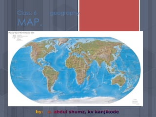
- 2. What is a map? A geographical representation of a sizable area of earth. On a flat surface By using a scale. abdul shumz kv kanjikode 2
- 3. What are the main parts to a map? Key or Legend Symbols Cardinal Directions Intermediate Directions Scale Water and Landforms Latitude and Longitudinal Lines etc. abdul shumz kv kanjikode 3
- 4. Types of Maps Political Maps – show boundaries between countries Physical Maps – show natural features and elevation changes on the earth. Thematic Maps – show specific information about a place and focus on a specific topic abdul shumz kv kanjikode 4
- 5. abdul shumz kv kanjikode 5
- 6. Topographical/Physical Map Of Finland Contour Map Topographical abdul shumz kv kanjikode 6
- 7. Movement Map of Beijing China abdul shumz kv kanjikode 7
- 8. Key or Legend Most maps will have some form of a key or legend located in one of the corners of the map. A key or legend contains the meanings of the symbols that the Cartographers (map makers) used when designing the map. abdul shumz kv kanjikode 8
- 9. Description Details Direction Distance Designation Maps are having scientific a language: The language is a system of assumptions: “Also known as the five D’s” abdul shumz kv kanjikode 9
- 10. Description Name, map number, scale and edition, legends, any symbols abdul shumz kv kanjikode 10
- 11. Details-Map Symbols Symbols are a maps alphabet They explain the lay of the land The symbols closely represent the feature they portray. abdul shumz kv kanjikode 11
- 12. Direction A quick glance at a map will show you the relative direction in which any point lies from any other point A map will always label North To determine true direction on a map you must know where you are starting from To do this, a map will label North in three different ways- TN-true north MN-Magnetic North GN-Grid North abdul shumz kv kanjikode 12
- 13. Distance Maps are always written with a scale. Eg: RF method Statement method abdul shumz kv kanjikode 13
- 14. Scale Scale is a way to measure distance on a map. Without a scale, it would be impossible to figure out how far it is from one town to another or how large a piece of land is. abdul shumz kv kanjikode 14
- 15. Designation Places, and other map features, are designated by name in various lettering styles. Example-water features are represented in blue italics abdul shumz kv kanjikode 15
- 16. A magnetic needle mounted on what is known as a compass rose. Because of the earth’s magnetic fields, the compass always points North, Aiding explorers in navigation, Considered the greatest invention in the world of exploration abdul shumz kv kanjikode 16
- 17. Latitude Longitude Prime Meridian International Date line Equator Tropic of Cancer and Tropic of Capricorn Arctic Circle and Antarctic Circle Hemisphere Scale Compass Key/Legend Map terms to remember: abdul shumz kv kanjikode 17
- 18. Cardinal Directions Cardinal Directions are: North South East West A way to remember the order of the cardinal directions is to remember the phrase “Never Eat Soggy Waffles” A Compass Rose is used on a map to show cardinal directions. abdul shumz kv kanjikode 18
- 19. by A. ABDUL SHUMZ KV Kanjikode abdul shumz kv kanjikode 19
- 20. abdul shumz kv kanjikode 20
- 21. abdul shumz kv kanjikode 21
- 22. abdul shumz kv kanjikode 22
- 23. abdul shumz kv kanjikode 23
- 24. abdul shumz kv kanjikode 24
- 25. A Compass Rose is a design on a map that shows the four Cardinal Directions. The Cardinal Directions include: North, South, East, and West. abdul shumz kv kanjikode 25
- 26. NORTH NORTH is the direction at the top of the compass rose.abdul shumz kv kanjikode 26
- 27. SOUTH SOUTH is the direction at the bottom of the compass rose. abdul shumz kv kanjikode 27
- 28. EAST EAST is the direction to the right on the compass rose.abdul shumz kv kanjikode 28
- 29. WEST WEST is the direction to the left on the compass rose.abdul shumz kv kanjikode 29
- 30. abdul shumz kv kanjikode 30
- 31. What direction is pointing toward the ? Click on the correct direction. North South West East? abdul shumz kv kanjikode 31
- 32. What direction is pointing toward the ? Click on the correct direction. South North East ? West abdul shumz kv kanjikode 32
- 33. What direction is pointing toward the ? Click on the correct direction.North South East West ? abdul shumz kv kanjikode 33
- 34. What direction is pointing toward the ? Click on the correct direction. North South East West ? abdul shumz kv kanjikode 34
- 35. WEST is the direction on the left. abdul shumz kv kanjikode 35
- 36. SOUTH is the direction at the bottom.abdul shumz kv kanjikode 36
- 37. NORTH is the direction at the top. abdul shumz kv kanjikode 37
- 38. EAST is the direction on the right. Great Job!! abdul shumz kv kanjikode 38
- 39. abdul shumz kv kanjikode 39
- 40. abdul shumz kv kanjikode 40
- 41. abdul shumz kv kanjikode 41
- 42. Grids A map grid helps to locate places quickly on a map. In science class, we have use grids to graph information. Latitude and Longitude lines are used to find absolute location on a map. abdul shumz kv kanjikode 42
- 44. abdul shumz kv kanjikode 44
- 45. Parallels of Latitude Parallels of Latitude or Latitude lines run laterally on a map but measure the distance north and south on a map. Latitude lines are measured in degrees (°) north or south latitude The equator is located at 0° latitude The Tropic of Cancer is located at 23 ½ ° N. latitude The Tropic of Capricorn is located at 23 1/2 ° S. latitude Between these two parallels of latitude are what we consider the “tropics” why? abdul shumz kv kanjikode 45
- 46. Meridians of Longitude Meridians of Longitudes are imaginary lines that run north and south but measure distances east and west of the prime meridian Longitude lines are measured in degrees (°) east or west The prime meridian is 0° longitude abdul shumz kv kanjikode 46
- 47. Longitude Lines and Time Zones abdul shumz kv kanjikode 47
- 48. abdul shumz kv kanjikode 48
- 49. varoius land forms: Mountain A high, steep place higher than a hill abdul shumz kv kanjikode 49
- 50. MOUNTAIN RANGE abdul shumz kv kanjikode A row of connected mountains 50
- 51. Mouth A part of a river where its water empties into a larger body of water abdul shumz kv kanjikode 51
- 52. Ocean Largest body of salt water abdul shumz kv kanjikode 52
- 53. Pampas Grassland (pampas is the term used for grassland in South America) abdul shumz kv kanjikode 53
- 54. PENINSULA abdul shumz kv kanjikode a piece of land that is nearly surrounded by water 54
- 55. Peninsula A piece of land that is nearly surrounded by water abdul shumz kv kanjikode 55
- 56. Plain A broad, flat stretch of land abdul shumz kv kanjikode 56
- 57. Plateau Flat or gentle rolling land that stands higher than the land around it abdul shumz kv kanjikode 57
- 58. RIVER abdul shumz kv kanjikode a large body of water that flows though the land 58
- 59. SEA abdul shumz kv kanjikode A body of salt water that is smaller then an ocean 59
- 60. SOUND abdul shumz kv kanjikode A long, narrow body of water, larger then a strait, that connects two lager bodies of water or separates an island from a mainland 60
- 61. SOURCE abdul shumz kv kanjikode The place where a river begins, usually in highlands 61
- 62. Strait A narrow channel that connects two larger bodies of water abdul shumz kv kanjikode 62
- 63. Tributary A stream or small river that flows into a larger river abdul shumz kv kanjikode 63
- 64. Tundra Frozen ground often found in the arctic region abdul shumz kv kanjikode 64
- 65. Valley A low area of land that lies between hills or mountains abdul shumz kv kanjikode 65
- 66. Volcano An opening in the earth’s crust that allows molten rock or ash to escape from the earth’s mantle abdul shumz kv kanjikode 66
- 67. Water Fall A stream that quickly falls over an erosion resistant rock formation abdul shumz kv kanjikode Angel Falls - Venezeula 67
- 68. abdul shumz kv kanjikode 68