1. 35September/October 2016
THE MODERN WIND TURBINE
is an amazing feat of engineer-
ing. Some models have blades
nearly 130 feet long, sweeping
an arc 260 feet in diameter,
anchored to a tower more
than 200 feet tall. But despite
their astounding design and
imposing appearance, every
now and then, someone has to
inspect those blades for cracks.
“You can stand on the
ground and look up,” using a
camera with a telephoto lens,
“but the more effective way
is to actually go down the
blades,” rappelling by ropes,
says Aleksandar Vukojevic,
manager of emerging technol-
ogies at Charlotte, NC-based
Duke Energy. After position-
ing the turbine blade at a
90-degree angle to the ground,
an inspector climbs all over
it. This method is both time-
consuming and dangerous
for human workers. A drone
with a high-resolution camera,
however, can get the job done
in less than 90 minutes. Any
job that requires climbing is
perfect for a drone, he says.
The FAA predicts com-
mercial drone sales will grow
from 600,000 units a year to
more than 2.7 million a year
by 2020. Certainly the most
sophisticated and expensive
of these machines will be put
to work by the private sector.
That entails a whole new gen-
eration of unmanned aircraft,
as well as people skilled in
handling them.MORE THAN A TOOL
“Interest in drones is
great,” says Gretchen West,
co-executive director of the
Commercial Drone Alliance
and senior advisor at Hogan
Lovells. “Companies and in-
dividual operators have been
very good at learning and fol-
lowing the rules. There are a
lot of resources out there now
to help them know when and
where they can fly.”
The challenge, she says, is
getting businesses to under-
stand drones are aircraft,
not just another tool. Like a
manned airplane or helicop-
ter, a commercial drone is sub-
ject to federal regulations.
The highly anticipated Part
107 regulations for commer-
cial drones were released in
June, and many in the indus-
try were hopeful for signifi-
cant changes like the ability to
fly beyond visual line-of-sight
(BVLOS). While BVLOS is
illegal, Part 107 makes it easier
for people to operate drones
commercially. The FAA notes
that waivers may be filed for
certain exemptions to Part
107’s requirements, including
BVLOS operations similar to
the Section 333 process. These
rules went into effect on Aug.
29, and up until then commer-
cial drone flying in the U.S.
still functioned under the Sec-
tion 333 exemption process.
Under Part 107, all com-
mercial drone pilots must
fly small unmanned aerial
systems (sUAS) that weigh
less than 55 pounds, during
daylight/civil twilight, within
visual line-of-sight, and under
400 feet. They must also pass
an FAA aeronautical knowl-
edge test (and pass again
every two years) to obtain a
remote pilot airman certificate.
(Read more about Part 107 on
Page 11.)
BETTER. FASTER. SAFER.
Even though current rules
and regulations in the U.S.
may seem restrictive, privately
held companies ― most of
MILESANDMILES
Infrastructure and utilities
inspections are some of the fastest-
growing commercial sectors for UAS
By David Ibata
INSEARCHOFPERFECTION
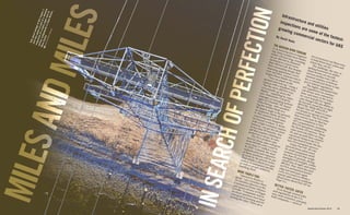
Talkaboutvertigo!ADJIInspire1
shotthisphotoaspartofadetailed
inspectionofahydrotowerandits
variouscomponentsinCapeBreton,
NovaScotia.AEROVISIONCANADA
2. consultant and chief operating
officer of UASolutions Group,
which advises companies and
helps them obtain certification.
“These guys have big
ponds of water, and they
sledge out of the bottom
certain types of sand and ag-
gregate,” she says. “Back in
the day, you literally had to
walk on top of the pile to do
a survey. Well, those piles are
really unstable, and there are
cases where men and women
have gotten stuck in them, and
it’s killed them. So now it’s
illegal to walk the stockpiles
to figure out how much mass
you have.”
Operators have flown
manned aircraft, costing hun-
dreds of dollars an hour, to
measure piles of mined mate-
rials. Now, many use drones.
“It’s easy and brilliant,”
Engh says. “If you’re paying
somebody $10,000 to do a
stockpile report and now you
can get it down to a $1,000
drone and one of the guys you
already have doing the report
internally, the cost benefit is
huge. The potential return on
investment is huge.”
Crop spraying is another
application ― not for large,
expansive fields, but over a
small area like a vineyard
where manned aircraft are not
economically feasible.
“We currently have a
couple of [Section 333] ap-
plications going through for
a crop sprayer that’s under 55
pounds,” Engh says. “Crop
duster guys can spray smaller
areas. They can determine
the return on investment,
when it’s worth it to pull a
big airplane out of the hangar,
and when it’s better to put a
55-pound unmanned aircraft
in the back of a truck and
drive down the road.”
CONVENIENCE ISN’T
ALWAYS BEST
AgPixel of Golden, CO,
uses both conventional and
unmanned aircraft to take
aerial images ― infrared,
near-infrared, and visible light
― to help farmers evaluate the
health of their fields.
“We’re finding drones
are very effective tools for
which have only been using
drones for 12 to 18 months ―
have identified hundreds of
possible applications for drone
tech. Whether scaling a rail-
road bridge to look for defects,
scrambling over piles of rock
to measure their volume, or
venturing into storm-devas-
tated neighborhoods to locate
downed power lines, most
anything that puts a human in
harm’s way can be performed
by a UAS.
Duke Energy has a 333
exemption for drone use in
the utilities sector and deploys
fixed-wing drones to monitor
solar farms. Malfunctioning
solar panels emit excess heat,
so the company relies on
drone-mounted infrared cam-
eras to spot faulty panels.
A single solar farm can
have as many as 100,000 pan-
els, according to Duke Energy
Communications Manager
Randy Wheeless. “Right now,
you have to go on foot, testing
each panel, and that takes
time,” he explains.
Vukojevic talks of using
drones to inspect power-plant
smoke stacks up to 400 feet
tall. “If you’re looking for
hairline cracks in the concrete,
sometimes you can do it with
a crane. But a lot of times, it’s
simply inaccessible.”
Another electrical utility
business, the Atlanta-based
Southern Company, flies its
drones indoors ― inside large
rooms at generation plants
housing boilers and other sys-
tems that carry steam for the
power conversion process.
“We fly the more low-end
consumer [multirotor] aircraft
... with prop guards, and you
can actually bump the sides
of boiler tubes when we’re
doing visual inspections,”
says Dexter Lewis, senior
research engineer for the
utility’s UAS.
Lewis hopes to use UAS to
patrol Southern Companies’
far-flung assets: more than
27,000 miles of transmission
lines, 100,000 miles of distribu-
tion lines, and 3,000 substa-
tions across four southern
states. Currently, the company
flies manned, fixed-wing
aircraft to patrol transmission
lines four times a year and he-
licopters for complete inspec-
tions once every six years.
“We can dream a little bit
and think maybe a couple of
years down the road, where
we have beyond visual line-of-
sight exemptions or approv-
als. Our assets have known
GIS (geographic information
system) information. We have
GPS tags,” says Lewis. “That
lines up really well with a
flight plan. If you can dispatch
a UAV to where you know
your assets are, in real time,
you can monitor information
that’s coming back. You can
set that aircraft on an auto-
matic flight plan.”
In the immediate aftermath
of a storm, a drone released
for preprogrammed cross-
country flight could rapidly
cover territory inaccessible
and dangerous to crews on
the ground. Visual recognition
algorithms in the aircraft’s
camera software could quickly
identify downed power poles
and lines.
Airplanes fly fast and high,
and helicopters can only go so
low. So most jobs, like check-
ing for broken insulators or
damaged conductors, require
employees on the ground or
in a bucket truck. Lewis calls
those jobs the obvious, low-
hanging fruit.
“Whenever you need to
do a local inspection ― lo-
cal being kind of within your
line-of-sight ― of any type
of vertical infrastructure (like
a pole or chimney), you can
quickly deploy an unmanned
aircraft and probably get bet-
ter inspection data than from a
traditional method, except for
climbing,” he says.
In the oil and gas indus-
try, drones often inspect flare
stacks ― tall vertical pipes, the
highest points of oil refineries
and offshore drilling platforms
that are used to burn off vola-
tile gases. They, too, typically
require sending inspectors up
in a bucket or ladder truck.
This process can take several
days, says Dyan Gibbens,
CEO of Trumbull Unmanned
and adviser to the oil and
gas industry. But a drone can
drastically reduce that inspec-
tion time to about 30 minutes.
“Drones help make legacy
inspection processes better,
faster, and safer,” Gibbens
says. They also help reduce
personal exposure, she ex-
plains, removing people from
harm’s way ― think danger-
ous heights or other hazard-
ous environments.
RETURN ON DRONE
Mention coal mines and the
lyrics to a Merle Travis song
may come to mind: “Where
the rain never falls, and the
sun never shines / It’s dark as
a dungeon, way down in the
mine.” But mining is brighter
thanks to drones.
Those in any type of ag-
gregate industry ― coal, dirt,
sand, rock ― are looking to
drones, especially mine opera-
tors, says Christina Engh, UAS
“DRONESHELPMAKELEGACYINSPECTION
PROCESSESBETTER,FASTER,ANDSAFER”
This shot of a refinery in Dartmouth, Nova Scotia, was taken to give
management an overall view of the refinery’s grounds. Commercial
inspections, surveying, mapping, and 3D modeling are becoming more
common jobs for unmanned aerial vehicles. AEROVISION CANADA
3. “DULL,DIRTY,ANDDANGEROUS—THAT’SWHEN
YOUSENDINUNMANNEDAIRCRAFT”
INTENDEDUSE
39September/October 2016
But the big payoff for
railroads will come when
they can fly drones beyond
a pilot’s sight limitation, as
the military has been doing
for years. For the nearly two
centuries of railroad history,
the thankless job of patrolling
miles of track has fallen to the
track inspector.
The Federal Railroad
Administration says that track
inspectors walk up to 10 miles
a day on uneven surfaces,
are in constant danger of
approaching trains, get close
to hazardous materials at acci-
dent scenes, and are exposed
to extreme temperatures and
precipitation, not to mention
the potential for disagreeable
insects, toxic vegetation, or
poisonous snakes.
“Dull, dirty, and danger-
ous — that’s when you send
in unmanned aircraft,” says
Engh. And the track inspec-
tor’s job is at least two of
those three, on a good day.
One of the first BVLOS
commercial demonstrations
occurred in September 2013,
when the FAA’s Alaska
Region worked with Insitu
on ScanEagle flights over the
Chukchi Sea, north of the
Arctic Circle. The energy com-
pany ConocoPhillips tested
drones for conducting the
marine mammal and ice sur-
veys that are required prior to
sea-floor drilling.
In one of the most recent
tests, an Xcel Energy drone
flew beyond visual line-of-
sight this past February to
survey a transmission line
near Amarillo, TX.
Foreign affiliates of U.S.
UAS operators are already
flying BVLOS operations.
Insitu announced in May that
after 18 months of trials, the
Queensland Gas Company, an
Australia-based Shell subsid-
iary, will use its ScanEagle to
inspect pipelines, gas wells,
and processing facilities. The
drone will be in the air up to
eight hours a day.
WAITING GAME
While drone tech has a lot
to offer in terms of use for
inspections, allowing UAS to
reach their maximum poten-
tial rests heavily upon future
government regulations.
West believes future legis-
lation will be strict, but that
doesn’t necessarily mean lim-
iting. While she says the FAA
is unlikely to approve flying
unmanned aircraft at night,
over people, or BVLOS any
time soon, the government
and its partners are research-
ing those areas.
“The FAA has been much
more forward-thinking just
in the last year … allow-
ing broader operations on a
one-off basis, which we hope
will be a precedent for future
rules,” she says.
Lewis believes starting
slow is a smart move.
“We’ll crawl, walk, and
then run,” says Lewis. “Just
from a conservative mindset,
that’s the best way to ap-
proach [future UAS regula-
tions]. You could argue that
with today’s regulatory
process, with the 333 exemp-
tions and the conditions and
limitations tied to those, we’re
crawling along.”
But when the FAA finally
allows widespread BVLOS
operations, he says, “then I
think we’ll be running.”
many applications, but not
always the best or most cost
effective,” says Kevin Price,
AgPixel’s executive vice presi-
dent of research and product
development. “In fact, they
can be the most expensive
way of collecting imagery over
agricultural land.”
A multirotor drone tasked
with capturing map-quality
images ― such detail is neces-
sary for programming field
machinery ― can cover about
50 acres a day, Price explains.
A fixed-wing drone can do
1,000 acres “on a good day, at
400 feet, the highest altitude
you’re allowed to fly.” A fixed-
winged manned aircraft like
a single-engine Cessna can
fly higher and process about
20,000 acres a day.
Section 333 exemptions and
Part 107 require two people
to fly a drone commercially,
a pilot and an observer. An
airplane requires only one per-
son, the pilot; it also can carry
a higher-resolution camera.
“A good, used Cessna can
be bought for almost as much
as drones are selling for now,
$20,000 to $30,000,” Price says.
But the buck doesn’t stop
there.
“People also forget that if
they buy a drone, they still
have to buy a truck to haul
the equipment, and that could
cost as much as a used Cessna,
too,” he says. “I’m not bad-
mouthing drones. We use
them, and we use them very
effectively. But sometimes
people get into drones and are
very disappointed they can’t
fly enough acres commercially
to make it worth their time.”
Drones make sense for
small farms and high-value
crops like produce, Price
explains, but not for massive
acres of plants like wheat
or corn. “You’re pounding a
square peg into a round hole
if you’re trying to use them for
1,500 acres of winter wheat,”
he says.
BVLOS: ALL ABOARD!
Like electrical utilities
and pipelines, railroads are a
natural application for drones,
given the long, linear nature of
their operations.
In 2015, Insitu, a wholly
owned subsidiary of The
Boeing Company based in
Bingen, WA, worked with the
BNSF Railway on one of the
most ambitious tests of BV-
LOS applications to date. The
company participated in the
FAA Pathfinder program to
help the government agency
develop future commercial
UAS regulations.
An Insitu-built ScanEagle, a
catapult-launched fixed-wing
drone with an endurance of
more than 24 hours, took off
from Vaughn, NM, to inspect
140 miles of track between the
towns of Mountainair and
Tolar. During 14 hours of
flight time, the aircraft looked
for washouts, bridge damage,
and other problems, transmit-
ting information in real time to
a team on the ground.
“The exercise demonstrated
how, in addition to a rail-
way company’s traditional
methods of track monitoring,
drones can be a powerful force
multiplier and further enhance
railway safety and infrastruc-
ture operation,” Insitu says
on its website, adding that
UAS “keep employees out of
harm’s way and harsh condi-
tions.” BNSF Railway and
other railroads either did not
respond to or declined inter-
view requests.
Even when subject to line-
of-sight limitations, railroads
are putting drones to work.
According to the Association
of American Railroads, when
record floods hit Texas and
Oklahoma in 2015, BNSF flew
drones with high-definition
video cameras to inspect areas
difficult to access from the
ground.
The Union Pacific Railroad
has used drones for close-
up visual work like bridge
inspections, which previ-
ously required crews in bucket
trucks or physically climbing
the structures.
AN ANALYSIS of 2014-
2015 Section 333
exemptions shows that
construction, utilities/
energy/infrastructure,
and agriculture each
make up about 11% of
intended operations.
Source: Center for the
Study of the Drone,
Bard College
Photo/Film
Real Estate
Construction
Infrastructure
Agriculture
Emergency
Services
Education
Government
Contracting
Insurance
Scientific
Conservation
Manufacturer
Other
More and more, quarries have
started using drones to measure
stockpiles like this one at Lannon
Stone in Sussex, WI. Drones help
save time, money, and possibly
even lives. TIM KIDWELL
![consultant and chief operating
officer of UASolutions Group,
which advises companies and
helps them obtain certification.
“These guys have big
ponds of water, and they
sledge out of the bottom
certain types of sand and ag-
gregate,” she says. “Back in
the day, you literally had to
walk on top of the pile to do
a survey. Well, those piles are
really unstable, and there are
cases where men and women
have gotten stuck in them, and
it’s killed them. So now it’s
illegal to walk the stockpiles
to figure out how much mass
you have.”
Operators have flown
manned aircraft, costing hun-
dreds of dollars an hour, to
measure piles of mined mate-
rials. Now, many use drones.
“It’s easy and brilliant,”
Engh says. “If you’re paying
somebody $10,000 to do a
stockpile report and now you
can get it down to a $1,000
drone and one of the guys you
already have doing the report
internally, the cost benefit is
huge. The potential return on
investment is huge.”
Crop spraying is another
application ― not for large,
expansive fields, but over a
small area like a vineyard
where manned aircraft are not
economically feasible.
“We currently have a
couple of [Section 333] ap-
plications going through for
a crop sprayer that’s under 55
pounds,” Engh says. “Crop
duster guys can spray smaller
areas. They can determine
the return on investment,
when it’s worth it to pull a
big airplane out of the hangar,
and when it’s better to put a
55-pound unmanned aircraft
in the back of a truck and
drive down the road.”
CONVENIENCE ISN’T
ALWAYS BEST
AgPixel of Golden, CO,
uses both conventional and
unmanned aircraft to take
aerial images ― infrared,
near-infrared, and visible light
― to help farmers evaluate the
health of their fields.
“We’re finding drones
are very effective tools for
which have only been using
drones for 12 to 18 months ―
have identified hundreds of
possible applications for drone
tech. Whether scaling a rail-
road bridge to look for defects,
scrambling over piles of rock
to measure their volume, or
venturing into storm-devas-
tated neighborhoods to locate
downed power lines, most
anything that puts a human in
harm’s way can be performed
by a UAS.
Duke Energy has a 333
exemption for drone use in
the utilities sector and deploys
fixed-wing drones to monitor
solar farms. Malfunctioning
solar panels emit excess heat,
so the company relies on
drone-mounted infrared cam-
eras to spot faulty panels.
A single solar farm can
have as many as 100,000 pan-
els, according to Duke Energy
Communications Manager
Randy Wheeless. “Right now,
you have to go on foot, testing
each panel, and that takes
time,” he explains.
Vukojevic talks of using
drones to inspect power-plant
smoke stacks up to 400 feet
tall. “If you’re looking for
hairline cracks in the concrete,
sometimes you can do it with
a crane. But a lot of times, it’s
simply inaccessible.”
Another electrical utility
business, the Atlanta-based
Southern Company, flies its
drones indoors ― inside large
rooms at generation plants
housing boilers and other sys-
tems that carry steam for the
power conversion process.
“We fly the more low-end
consumer [multirotor] aircraft
... with prop guards, and you
can actually bump the sides
of boiler tubes when we’re
doing visual inspections,”
says Dexter Lewis, senior
research engineer for the
utility’s UAS.
Lewis hopes to use UAS to
patrol Southern Companies’
far-flung assets: more than
27,000 miles of transmission
lines, 100,000 miles of distribu-
tion lines, and 3,000 substa-
tions across four southern
states. Currently, the company
flies manned, fixed-wing
aircraft to patrol transmission
lines four times a year and he-
licopters for complete inspec-
tions once every six years.
“We can dream a little bit
and think maybe a couple of
years down the road, where
we have beyond visual line-of-
sight exemptions or approv-
als. Our assets have known
GIS (geographic information
system) information. We have
GPS tags,” says Lewis. “That
lines up really well with a
flight plan. If you can dispatch
a UAV to where you know
your assets are, in real time,
you can monitor information
that’s coming back. You can
set that aircraft on an auto-
matic flight plan.”
In the immediate aftermath
of a storm, a drone released
for preprogrammed cross-
country flight could rapidly
cover territory inaccessible
and dangerous to crews on
the ground. Visual recognition
algorithms in the aircraft’s
camera software could quickly
identify downed power poles
and lines.
Airplanes fly fast and high,
and helicopters can only go so
low. So most jobs, like check-
ing for broken insulators or
damaged conductors, require
employees on the ground or
in a bucket truck. Lewis calls
those jobs the obvious, low-
hanging fruit.
“Whenever you need to
do a local inspection ― lo-
cal being kind of within your
line-of-sight ― of any type
of vertical infrastructure (like
a pole or chimney), you can
quickly deploy an unmanned
aircraft and probably get bet-
ter inspection data than from a
traditional method, except for
climbing,” he says.
In the oil and gas indus-
try, drones often inspect flare
stacks ― tall vertical pipes, the
highest points of oil refineries
and offshore drilling platforms
that are used to burn off vola-
tile gases. They, too, typically
require sending inspectors up
in a bucket or ladder truck.
This process can take several
days, says Dyan Gibbens,
CEO of Trumbull Unmanned
and adviser to the oil and
gas industry. But a drone can
drastically reduce that inspec-
tion time to about 30 minutes.
“Drones help make legacy
inspection processes better,
faster, and safer,” Gibbens
says. They also help reduce
personal exposure, she ex-
plains, removing people from
harm’s way ― think danger-
ous heights or other hazard-
ous environments.
RETURN ON DRONE
Mention coal mines and the
lyrics to a Merle Travis song
may come to mind: “Where
the rain never falls, and the
sun never shines / It’s dark as
a dungeon, way down in the
mine.” But mining is brighter
thanks to drones.
Those in any type of ag-
gregate industry ― coal, dirt,
sand, rock ― are looking to
drones, especially mine opera-
tors, says Christina Engh, UAS
“DRONESHELPMAKELEGACYINSPECTION
PROCESSESBETTER,FASTER,ANDSAFER”
This shot of a refinery in Dartmouth, Nova Scotia, was taken to give
management an overall view of the refinery’s grounds. Commercial
inspections, surveying, mapping, and 3D modeling are becoming more
common jobs for unmanned aerial vehicles. AEROVISION CANADA](data:image/gif;base64,R0lGODlhAQABAIAAAAAAAP///yH5BAEAAAAALAAAAAABAAEAAAIBRAA7)