
Recommandé
Contenu connexe
Similaire à EOPS_2018_06_28.pdf
Similaire à EOPS_2018_06_28.pdf (20)
Plus de EOPS EOPS
Dernier
Dernier (20)
EOPS_2018_06_28.pdf
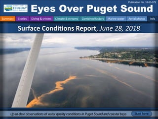
- 1. Surface Conditions Report, June 28, 2018 Eyes Over Puget Sound Publication No. 18-03-072 Up-to-date observations of water quality conditions in Puget Sound and coastal bays Start here Summary Stories Diving & critters Climate & streams Combined factors Marine water Aerial photos Info
- 2. Personal stories p. 3 Meet Stephen Gonski, our ocean acidification expert. Climate & Streams p. 6 River flows have rapidly declined from May, but snow-fed river flows in particular have been highly variable toward the end of June. Precipitation levels are below normal with abundant sunshine. With projected drier and warmer conditions, will the remaining snowpack translate to low stream flows in September? Testing an infrared camera p. 10 Juvenile fish are migrating out of the estuaries and meeting a complex thermal habitat. Will they hit optimal temperatures to grow? See the new infrared images. Aerial photography p. 14 A large Noctiluca bloom extends across South Central Basin and coccolithophores bloom in Hood Canal. macroalgae present on many beaches in South Sound, Central Sound, and Whidbey Basin and adrift in Port Madison, South Central Basin, and South Sound. LONG-TERM MARINE MONITORING UNIT Editorial assistance provided by: Suzan Pool, Dany Burgess, and Carol Maloy Summary conditions at a glance Skip Albertson Dr. Christopher Krembs (Editor) Tyler Burks Jim Shedd Summary Stories Diving & critters Climate & streams Combined factors Marine water Aerial photos Info Stephen Gonski
- 3. Meet our new Ocean Acidification Scientist Personal Field Impression Personal stories and field impressions Summary Stories Diving & critters Climate & streams Combined factors Marine water Aerial photos Info Stephen Gonski joined our marine team to develop and implement the ocean acidification (OA) component of our monitoring program. He has worked extensively with biogeochemical sensors and studied OA in both estuarine and coastal ocean systems. Stephen graduated from the University of Delaware with a BS in Environmental Chemistry and an MS in Oceanography. Fieldwork has taken him to the Hawai’ian Islands, Norway, Svalbard, and the Canadian Arctic, and now Puget Sound. This sensor in Murderkill Estuary near Delaware Bay has run afoul. It takes a scientist with a clear mind and fresh ideas (contrary to this sensor’s appearance) to tackle estuarine sensor deployments. SeapHOx Sensor Sensor vs. Scientist!
- 4. Best and Worst horizontal visibility and corresponding depth (ft) # Best Worst This is a new feature and we are soliciting feedback (skip.albertson@ecy.wa.gov). good poor visibility What was the visibility in the water for divers? What can you find underwater? Summary Stories Diving & critters Climate & streams Combined factors Marine water Aerial photos Info 1 19 98 16 10 2 13 23 2 7 3 17 98 14 23 4 37 98 5 23 5 16 98 8 7 6 36 98 5 23 7 26 59 2 2 8 13 26 4 3 9 22 89 6 7 10 28 57 4 34 11 27 98 3 5 12 6 7 6 34 13 24 98 14 3 14 21 80 9 8 15 15 94 11 3 16 20 30 5 13 June Find depths with high/low visibility • Best visibility was 37 feet, deep in Saratoga Passage (stations 4 and 6), in about same location as last month. • Poor visibility occurred in Oakland Bay (near Shelton) , but also in Bellingham Bay. • We use transmissometer readings from our CTD package and convert them into horizontal visibility. The poster, Underwater Visibility Maps – a Tool for Scuba Divers, is available at: Click here best in survey
- 5. Critter of the Month – The “Unicorn Shrimp” Dany Burgess & Angela Eagleston Marine Sediment Monitoring Team Fun Leptostracan Facts • Some species can live in extreme environments, like deep-sea hydrothermal vents. • Breathe through their legs. • N. pugettensis spend their days buried in the mud of Puget Sound, emerging for a swim at night to feed on particles of organic matter and detritus. Learn more about leptostracans and other critters on Ecology’s EcoConnect blog here Nebalia pugettensis This critter has no official common name, but with the projection on its head, we think “Unicorn Shrimp” is fitting! The leptostracans aren’t actually shrimp, but a primitive group of crustaceans with a unique set of qualities all their own. What can you find underwater? Summary Stories Diving & critters Climate & streams Combined factors Marine water Aerial photos Info
- 6. How much water flows into coastal marine waters? Tyler Burks, Jim Shedd Near normal air temperatures and continued low precipitation during June have resulted in highly variable freshwater inputs to Puget Sound (map, center). Runoff from snow- dominated rivers varied from below to near normal, dependent on remaining snowpack and melt conditions in June (map panel, left). Rain-dominated rivers are much below normal in many cases, with regional exceptions from recent precipitation. Summary Stories Diving & critters Climate & streams Combined factors Marine water Aerial photos Info Current Streamflow Conditions as of 7/2/2018 Snowpack Conditions Current conditions: CLICK HERE! June 11 July 2
- 7. The combined reservoir storage of Chester Morse Lake, Masonry Pool, Masonry Pool, Lake Youngs, and South Fork Tolt Reservoir is near the long term average for this time of the year. WY = water year. Click here The maps on the top show higher probability of below normal precipitation in the NW. The maps on the bottom show a higher probability of higher temperatures in the west. Click here Climatologists predict drier and warmer conditions this summer. The current available snowpack is declining but about average for this time of year. Will these conditions translate to low stream flows in September? The reservoirs serving Seattle are near average, and that is good. July 2018 July-Aug-Sep 2018 Precipitation Temperature How much water flows into coastal marine waters? Summary Stories Diving & critters Climate & streams Combined factors Marine water Aerial photos Info Seattle Public Utilities Water System Synopsis Climate Prediction Center, NOAA
- 8. Climateinfluences:HowwellisPugetSoundexchangingits water? The Fraser River is the major driver of estuarine circulation and water exchange with the ocean. Fraser River flows have rapidly fallen and the snowpack in BC is below normal (Basin Snow Water Index) Historically, peaks of coastal upwelling and the freshet are in sync. Will they be this year? NPGO (x10) PDO/Upwelling Index How do ocean boundary conditions affect the quality of water we exchange with the ocean? Past years’ warm water is gone (PDO), upwelling is neutral (Upwelling Index anomaly), and surface productivity along the coast is lower (NPGO). Pacific Decadal Oscillation Index (PDO, temperature, explanation). Upwelling Index (anomalies) (Upwelling, low oxygen, explanation). North Pacific Gyre Oscillation Index (NPGO, productivity, explanation). Three-year running average of PDO, Upwelling, and NPGO indices Summary Stories Diving & critters Climate & streams Combined factors Marine water Aerial photos Info Higher than normal Lower than normal Expected Fraser River -25 -15 -5 5 15 25 -1.5 -1 -0.5 0 0.5 1 1.5 1945 1950 1955 1960 1965 1970 1975 1980 1985 1990 1995 2000 2005 2010 2015
- 9. What’s the story of influences affecting water quality? higher No data lower expected *Upwelling/downwelling Anomalies (PFEL) PDO = Pacific Decadal Oscillation NPGO = North Pacific Gyre Oscillation ENSO = El Niño Southern Oscillation Climate and natural influences include weather, river flows, and the adjacent ocean conditions that affect our marine waters. This graphic provides context for interpreting Puget Sound marine conditions. All data are from public sources: weather from UW GRAYSKIES; river flows from USGS and Environment Canada; indices from NOAA, UW (PDO), and E. Di Lorenzo (NPGO). Summary Stories Diving & critters Climate & streams Combined factors Marine water Aerial photos Info Summary: Air temperatures were above normal for May, but closer to normal in June. Precipitation levels have been below normal in May and June. Sunshine levels have been above normal (low cloud cover). River flows are much lower in June than May, but highly variable during the past week. Upwelling is normal, but lower than in May. ENSO is slightly positive, indicating the end of La Niña.
- 10. Summary Stories Diving & critters Climate & streams Combined factors Marine water Aerial photos Info Did you know: River deltas can have complex temperatures A. Skokomish River delta (Hood Canal) B. Eagle Creek delta (Hood Canal) Migrating juvenile salmon face a complex thermally structured habitat in estuaries that can make or break a successful recruiting year. See what it looks like using an infrared camera from 2500 feet. The same picture with a regular camera in comparison does not reveal much of the thermal complexity and flows of cooler river water. 6-28-2018 6-28-2018
- 11. Summary Stories Diving & critters Climate & streams Combined factors Marine water Aerial photos Info Did you know: The infrared camera shows what the eye can’t see A. Colder Hamma Hamma River plume B. Colder Duckabush River plume Once the cooler rivers enter Hood Canal surface water, the extent of the river plume can be seen on infrared images. On images using a regular camera this structure is not visible. For salmon, a temperature difference of 5 °C means a lot. 6-28-2018 6-28-2018
- 12. Summary Stories Diving & critters Climate & streams Combined factors Marine water Aerial photos Info Did you know: Water on mudflats can have different temperatures A. South Fork of Skagit River delta, mudflats B. Stillaguamish River delta, mudflats During low tides mudflats bake in the sun. A. Some water can reach up to 20 °C, B. while cooler river water provides a cool refuge. Differences in water temperature between B. the Skagit South Fork (11.8 °C, Sp2) and the Stillaguamish North Fork (15.2 °C, Sp1 ) can be seen on one infrared image. 6-28-2018 6-28-2018 Skagit South Fork Stillaguamish North Fork
- 13. Did you know: Patches of drifting organic material are warmer Summary Stories Diving & critters Climate & streams Combined factors Marine water Aerial photos Info A. Noctiluca accumulating at front B. macroalgae patch and Noctiluca Surface water is warmed by the sun. Organic material floating on the surface traps the heat and shows up to 8 °C temperature differences. Crustaceans and other larvae might benefit from these warm and sheltered little floating heated microcosms. macroalgae 6-28-2018 6-28-2018
- 14. What are conditions at the surface? Start here Bloom Debris Front Plume Narrow Hammersley Inlet connecting Oakland Bay Mixing and Fronts: Tidal fronts visible in Dana Passage. Debris: Noctiluca bloom surfacing along Normandy Park, numerous macroalgae adrift in Central and South Sound. Visible blooms: Orange Noctiluca bloom in South Central Basin. Turquoise coccolithophore bloom in Hood Canal. Red-brown blooms in finger inlets of South Sound and Port Townsend Bay. Jellyfish: Occasional jellyfish patches in Hood Canal near Hamma Hamma River. No jellyfish patches seen in South Sound. Suspended sediment: Suspended sediments nearshore due to very low tides. Large Noctiluca bloom in South Central Basin and a coccolithophore bloom in Hood Canal. Macroalgae present on many beaches of South Sound, Central Sound, and Whidbey Basin. Macroalgae drifting at the surface of Port Madison, Southern Central Basin, and South Sound. Summary Stories Diving & critters Climate & streams Combined factors Marine water Aerial photos Info Macroalgae growing in Quilcene Bay Dabob Bay with strong coccolithophore bloom macroalgae
- 15. Strait of Juan de Fuca San Juan Islands Padilla Bay Main Basin Hood Canal Whidbey Basin 1 Low ceiling low visibility. Flight Information: Aerial photography and navigation guide Flight routes 7 3 13 15 South Sound Tide data from June 28, 2018 (Seattle): Height (ft) High/Low 12:13 AM 7.03 L 04:47 AM 10.02 H 11:48 AM -1.61 L 7:27 PM 11.42 H 2 Summary Stories Diving & critters Climate & streams Combined factors Marine water Aerial photos Info 16 17 19 20 5 8 10 11 12 4 6 14 18 9
- 16. Skokomish River delta at very low tide exposing macroalgae. Location: Union (Hood Canal), 12:06 PM 1 Aerial photography 6-28-2018 Navigate Summary Stories Diving & critters Climate & streams Combined factors Marine water Aerial photos Info Union macroalgae
- 17. Hamma Hamma River delta at low tide exposing macroalgae. Stephen taking infrared images of estuaries. Location: Eldon (Hood Canal), 12:13 PM 2 Navigate Summary Stories Diving & critters Climate & streams Combined factors Marine water Aerial photos Info Aerial photography 6-28-2018 macroalgae
- 18. Duckabush River delta at very low tide exposing macroalgae. Turquoise coccolithophore bloom Location: Duckabush River (Hood Canal), 12:18 PM 3 Navigate Summary Stories Diving & critters Climate & streams Combined factors Marine water Aerial photos Info Aerial photography 6-28-2018 Bloom macroalgae
- 19. Dosewallips River delta at very low tide exposing macroalgae and green water. Location: Dosewallips River (Hood Canal), 12:20 PM 4 Navigate Summary Stories Diving & critters Climate & streams Combined factors Marine water Aerial photos Info Aerial photography 6-28-2018 Bloom macroalgae
- 20. Red-brown and warmer water (13.8 °C) with turquoise color meeting in Port Townsend Bay. Location: Off Indian Island (North Sound), 12:34 PM Indian Island 5 Navigate Summary Stories Diving & critters Climate & streams Combined factors Marine water Aerial photos Info Aerial photography 6-28-2018
- 21. Kelp beds north of coast, off Fort Worden State Park. Location: Fort Worden State Park (Admiralty Reach), 12:37 PM 6 Navigate Summary Stories Diving & critters Climate & streams Combined factors Marine water Aerial photos Info Aerial photography 6-28-2018 Fort Worden State Park kelp
- 22. 7 Navigate Summary Stories Diving & critters Climate & streams Combined factors Marine water Aerial photos Info Aerial photography 6-28-2018 Macroalgae growing in large mats on beaches north of Langley. Location: Saratoga Passage (Whidbey Basin), 12:56 PM Whidbey Island macroalgae
- 23. Macroalgae mats on beaches and drifting in Port Madison. Location: Port Madison (Central Sound), 1:11 PM 8 Navigate Summary Stories Diving & critters Climate & streams Combined factors Marine water Aerial photos Info Aerial photography 6-28-2018 Suquamish Debris Indianola macroalgae
- 24. Large ribbons of Noctiluca accumulating at the surface and beaches. Location: Three Tree Point (Central Sound), 1:29 PM 9 Navigate Summary Stories Diving & critters Climate & streams Combined factors Marine water Aerial photos Info Aerial photography 6-28-2018 Three Tree Point Debris
- 25. Noctiluca accumulating at the surface and beaches. Location: Normandy Park (Central Sound), 1:46 PM 10 Navigate Summary Stories Diving & critters Climate & streams Combined factors Marine water Aerial photos Info Aerial photography 6-28-2018 Normandy Park Debris
- 26. Ribbons of Noctiluca accumulating at beaches from Normandy Park to Des Moines. Location: Normandy Park and Des Moines (Central Sound), 1:29 PM Navigate 11 Summary Stories Diving & critters Climate & streams Combined factors Marine water Aerial photos Info Aerial photography 6-28-2018 Marine View Park Marine View Park Debris Debris
- 27. Navigate Large ribbons of Noctiluca accumulating at the surface. Location: Off Chautauqua, Vashon Island (Central Sound), 1:30 PM 12 Summary Stories Diving & critters Climate & streams Combined factors Marine water Aerial photos Info Aerial photography 6-28-2018 Chautauqua Debris
- 28. Navigate Large ribbons of Noctiluca and macroalgae accumulating at the surface. Location: Poverty Bay (Central Sound), 1:34 PM 13 Summary Stories Diving & critters Climate & streams Combined factors Marine water Aerial photos Info Aerial photography 6-28-2018 Poverty Bay Debris Debris
- 29. Front off Piner Point and sediment-rich water from the Puyallup River plume. Location: Maury Island (Central Sound), 1:36 PM Navigate 14 Summary Stories Diving & critters Climate & streams Combined factors Marine water Aerial photos Info Aerial photography 6-28-2018 Piner Point Debris Front macroalgae
- 30. Macroalgae growing in large mats on northern beaches of McNeil Island. Location: McNeil Island (South Sound), 1:46 PM Navigate 15 Summary Stories Diving & critters Climate & streams Combined factors Marine water Aerial photos Info Aerial photography 6-28-2018 McNeil Island macroalgae
- 31. Macroalgae drifting in mats south of McNeil Island. Location: McNeil Island (South Sound), 1:16 PM Navigate 16 Summary Stories Diving & critters Climate & streams Combined factors Marine water Aerial photos Info Aerial photography 6-28-2018 McNeil Island Anderson Island Debris
- 32. Red-brown bloom next to tidal front. Floating macroalgae mats. Location: Dana Passage (South Sound), 1:53 PM Navigate 17 Summary Stories Diving & critters Climate & streams Combined factors Marine water Aerial photos Info Aerial photography 6-28-2018 Harstine Island Squaxin Island Bloom Debris
- 33. Red-brown bloom. No jellyfish. Macroalgae on beaches. Location: Eld Inlet (South Sound), 1:57 PM Navigate 18 Summary Stories Diving & critters Climate & streams Combined factors Marine water Aerial photos Info Aerial photography 6-28-2018 Frye Cove County Park Cooper Point Bloom macroalgae
- 34. Red-brown bloom. Location: Eld Inlet (South Sound), 2:00 PM Navigate 19 Summary Stories Diving & critters Climate & streams Combined factors Marine water Aerial photos Info Aerial photography 6-28-2018 Young Cove Bloom macroalgae
- 35. Red-brown bloom. Location: Budd Inlet (South Sound), 2:00 PM Navigate 20 Summary Stories Diving & critters Climate & streams Combined factors Marine water Aerial photos Info Aerial photography 6-28-2018 Bloom
- 36. Find past editions of EOPS with images on last pages Summary Stories Diving & critters Climate & streams Combined factors Marine water Aerial photos Info We have published 74 editions! Recommended Citation (example from August 2017): Washington State Department of Ecology. 2017. Eyes Over Puget Sound, Surface Conditions Report, August 28, 2017. Ecology Publication No. 17-03-072. https://fortress.wa.gov/ecy/publications/documents/1703072.pdf Find all previous Eyes Over Puget Sound editions at the end of this document. Contact: Dr. Christopher Krembs, ckre461@ecy.wa.gov Marine Monitoring Unit Environmental Assessment Program WA Department of Ecology You may subscribe or unsubscribe to the Eyes Over Puget Sound email listserv by going to: http://listserv.ecology.wa.gov/scrip ts/wa-ECOLOGY.exe?A0=ECOLOGY- EYES-OVER-PUGET-SOUND Many thanks to our business partners: Shannon Point Marine Lab (WWU), Swantown Marina, and Kenmore Air, and Integral Consulting for the loan of the infrared camera.
- 37. Month_date_year, Publication No. 20-03-07X Month_date_year, Publication No. 20-03-07X Month_date_year, Publication No. 20-03-07X Month_date_year, Publication No. 20-03-07X March_16_2020, Publication No. 20-03-071 Jan_10_2020, Publication No. 20-03-070 October_30_2019, Publication No. 19-03-076 September_12_2019, Publication No. 19-03-075 July_29_2019 Publication No. 19-03-074 June_4_2019, Publication No. 19-03-073 March_26_2019, Publication No. 19-03-072 February_21_2019, Publication No. 19-03-071 January_10_2019, Publication No. 19-03-070 November_6_2018, Publication No. 18-03-075 September_17_2018, Publication No. 18-03-074 July_16_2018, Publication No. 18-03-073 June_28_2018, Publication No. 18-03-072 May_22_2018, Publication No. 18-03-025 April_19_2018, Publication No. 18-03-071 Winter_2018, Publication No. 18-03-070
- 38. October_31_2017, Publication No. 17-03-073 August_28_2017, Publication No. 17-03-072 July_24_2017, Publication No. 17-03-071 June_6_2017, Publication No. 17-03-070 December_31_2016, Publication No. 16-03-079 November_22_2016, Publication No. 16-03-078 September_26_2016, Publication No. 16-03-077 August_24_2016, Publication No. 16-03-076 July_20_2016, Publication No. 16-03-075 June_27_2016, Publication No. 16-03-074 May_2_2016, Publication No. 16-03-073 April_6_2016, Publication No. 16-03-072 March_16_2016, Publication No. 16-03-071 February_8_2016, Publication No. 16-03-070 December_30_2015, Publication No. 15-03-080 December_14_2015, Publication No. 15-03-079 October_6_2015, Publication No. 15-03-078 September_21_2015, Publication No. 15-03-077 August_8_2015, Publication No. 15-03-076 July_6_2015, Publication No. 15-03-075
- 39. June_8_2015, Publication No. 15-03-074 April_29_2015, Publication No. 15-03-073 March_24_2015, Publication No. 15-03-072 February_17_2015, Publication No. 15-03-071 January_28_2015, Publication No. 15-03-070 December_30_2014, Publication No. 14-03-080 November_17_2014, Publication No. 14-03-079 October_29_2014, Publication No. 14-03-078 September_16_2014, Publication No. 14-03-077 August_18_2014, Publication No. 14-03-076 July_28_2014, Publication No. 14-03-075 June_23_2014, Publication No. 14-03-074 May_12_2014, Publication No. 14-03-073 April_21_2014, Publication No. 14-03-072 March_24_2014, Publication No. 14-03-071 February_4_2014, Publication No. 14-03-070 December_31_2013, Publication No. 13-03-081 November_21_2013, Publication No. 13-03-080 October_28_2013, Publication No. 13-03-079 September_11_2013, Publication No. 13-03-078
- 40. August_21_2013, Publication No. 13-03-077 July_15_2013, Publication No. 13-03-076 June_17_2013, Publication No. 13-03-075 May_20_2013, Publication No. 13-03-074 April_8_2013, Publication No. 13-03-073 Mar_25_2013, Publication No. 13-03-072 February_26_2013, Publication No. 13-03-071 January_15_2013, Publication No. 13-03-070 December_13_2012, Publication No. 12-03-081 November_8_2012, Publication No. 12-03-080 October_8_2012, Publication No. 12-03-079 September_11_2012, Publication No. 12-03-078 August_27_2012, Publication No. 12-03-077 July_31_2012, Publication No. 12-03-076 June_12_2012, Publication No. 12-03-075 May_14_2012, Publication No. 12-03-074 April_23_2012, Publication No. 12-03-073 March_19_2012, Publication No. 12-03-072 February_27_2012, Publication No. 12-03-071 January_30_2012, Publication No. 12-03-070
- 41. December_5_2011, Publication No. 11-03-082 November_15_2011, Publication No. 11-03-081 October_17_2011, Publication No. 11-03-080 September_12_2011, Publication No. 11-03-079 August_8_2011, Publication No. 11-03-078 July_6_2011, Publication No. 11-03-077 June_20_2011, Publication No. 11-03-076 June_6_2011, Publication No. 11-03-075 May_4_2011, Publication No. 11-03-074 April_27_2011, Publication No. 11-03-073