
Recommandé
Contenu connexe
Tendances
Tendances (20)
En vedette
En vedette (12)
Similaire à Plates
Similaire à Plates (20)
Dernier
Dernier (20)
Plates
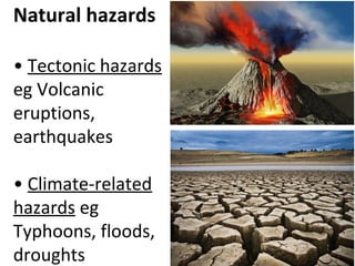
- 1. Natural hazards • Tectonic hazards eg Volcanic eruptions, earthquakes • Climate-related hazards eg Typhoons, floods, droughts
- 2. Natural hazards - a natural event that threatens human lives and causes damage to property.
- 3. b. What is the internal structure of the earth?
- 4. Crust • Oceanic crust is found beneath oceans • Continental crust is found beneath the continents • Thickness ranges from a few km to more than 70 km What is the internal structure of the earth? When the rocks in the mantle melt, hot molten rock called magma is formed.
- 5. Oceanic crust vs Continental crust Oceanic Crust • Located beneath deep ocean • Very thin — between 5 and 8 km • Denser (e.g. basalt) Continental Crust • Located beneath land masses and under shallow seas • Very thick — between 30 and 60 km • Less dense (e.g. granite)
- 6. Plates moving away from each other Platesmoving towards eachother Platesmoving towardseach other Plates Ocean floor Why do tectonic plates move?
- 7. 1. Convection currents •Material in the mantle is heated by the core. •Mantle expands, rises and spreads out beneath the plates. •Plates are dragged along and move away from each other. •Subsequently, the magma cools slightly and sinks, pulling the plates along •Hence plates move towards each other. •The sinking mantle material heats up again as it nears the core and the whole process repeats. Why do tectonic plates move?
- 8. 2. Slab-pull force • This occurs when an oceanic plate (denser) subducts under a less dense plate and pulls the rest of the plate along. • The subducting plate drives the downward-moving portion of convection currents. • Causes plates to move towards each other Why do tectonic plates move?
- 9. 3 types of plate boundaries
- 10. Types of movement Types of plates Landforms Examples Divergent - plates move away from each other Oceanic-oceanic plate divergence Oceanic ridges Mid-Atlantic Ridge Continental-continental plate divergence Rift valley, volcanoes The Great Rift Valley Convergent - plates move towards each other Oceanic–oceanic plate convergence Oceanic trenches, volcanoes, island arc Mariana Trench, Mariana Islands, Hawaii Islands Continental–oceanic plate convergence Ocean trenches, mountain ranges Sunda Trench, Barisan Mountains Continental–continental plate convergence Mountain ranges Himalayas Transform - plates move past each other Continental-continental plates sliding past each other None St Andreas Fault
- 11. Describe the plate movement and landforms 1) What are the two plates involved? 2) What is the plate movement? 3) What happens at the movement? 4) Is there any construction or destruction of plates? 5) What are the landforms created?
- 12. 1. Oceanic-oceanic plate divergence
- 13. 1. Oceanic-oceanic plate divergence OceanicOceanic plateplate OceanicOceanic plateplate
- 14. • Two oceanic plate move away from each other • As plates diverge, a crack/gap is formed • Magma rises from the mantle to fill up the gap • New sea floor is formed when the magma cools and solidifies. This process is called sea-floor spreading. • At the zone of divergence/spreading zone, new ocean floor is formed as the mid-oceanic ridge. • The newly formed (youngest) rocks are closest to the plate boundaries. • At various points along the ridge, magma builds up above the ocean to form volcanic islands. • E.g. the Mid-Atlantic Ridge is found in the middle of the Atlantic Ocean cutting across Iceland, a volcanic island. 1. Oceanic-oceanic plate divergence
- 15. 2. Continental–continental plate divergence • Two continental plate moves away from each other • Results in cracks / fault lines created • Middle section sinks, while adjacent side remains • Results in RIFT VALLEY and BLOCK MOUNTAINS
- 16. • A rift valley is a low land valley with steep sides , and a flat valley floor formed along fault lines. • A block mountain is a block of land with steep sides. It is formed when sections of the crust extend along fault lines and rock masses surrounding a central block sink due to tensional forces.
- 17. • A fault is a fracture in the rocks along which the rocks are displaced. • The tensional forces result in parts of the crust being fractured. • This process is called faulting. 2. Continental–continental plate divergence
- 18. EXAMPLES Linear sea - Red Sea and Gulf of Aden near the Great Rift Valley –Elongated/linear shape –1,900 km long, 300 km at its widest stretch, Average depth of 500 m –Evidence of tectonic activity — formation of new volcanic island in Red Sea 2. Continental–continental plate divergence
- 19. EXAMPLES Great Rift Valley (East Africa) – formed by Somalian boundary of the African Plate moving away from the Nubia plate boundary of the African Plate – 6,000 kilometres long, 30 to 100 kilometres wide – Evidence of tectonic activity: active volcanoes and earthquake fractures found 2. Continental–continental plate divergence
- 20. • Distribution of rift valleys and block mountains
- 21. 3. Oceanic–oceanic plate convergence
- 22. • Earthquakes may also occur. • E.g. the Pacific Plate converging with the slower-moving Philippine plate 3. Oceanic–oceanic plate convergence OceanicOceanic plateplate OceanicOceanic plateplate
- 23. 3. Oceanic–oceanic plate convergence • Two oceanic plates move towards each other • The heavier oceanic plate subducts under the lighter plate. • A subduction zone forms, creating a deep oceanic trench. • The subduction of the oceanic plate causes the crust to melt and magma is formed. • The magma rises to emerge as volcanoes. • Eventually a chain or arc of islands called island arc is formed.
- 24. Continental crust Continental crust Himalayas Tibetan Plateau Uppermost mantle Asthenosphere EURASIAN PLATE INDIAN PLATE 4. Continental – Continental plate convergence E.g. The Himalayas
- 25. 4. Continental – Continental plate convergence ContinentalContinental plateplate ContinentalContinental plateplate
- 26. • Two continental plates move towards each other • Both plates have similar densities and hence, resist subduction. • The plates break, slide along fractures in the crust and fold, forming fold mountains. • E.g. the Himalayas - convergence of the Indian Plate and the Eurasian Plate. 4. Continental – Continental plate convergence
- 27. 5. Oceanic – Continental plate convergence
- 28. 5. Oceanic – Continental plate convergence ContinentalContinental plateplate OceanicOceanic plateplate
- 29. • An oceanic plate and continental plate moves towards each other • The denser oceanic plate subducts under the less dense continental plate. • A subduction zone forms, creating a deep oceanic trench along the plate boundary. • The subduction of the continental plate causes the plate to melt and magma is formed. • The magma rises through the mantle and crust to emerge as volcanoes on land. • The edge of thick continental plate buckles to form fold mountains. • Earthquakes may also occur. • E.g. the Australian Plate subducting under a section of the Eurasian Plate near Sumatra formed the Sunda Trench. 5. Oceanic – Continental plate convergence
- 30. Fold mountains • Over millions of years, the folding of rocks creates a landform called fold mountains. • The Himalayas, the Rocky Mountains and the Andes are examples of fold mountains. • Fold mountains are formed along convergent plate boundaries. • The compressional force causes the layers of rocks to buckle and fold. • This process is known as folding.
- 31. Fold mountains The Himalayas Peak : Mount Everest (between Nepal and Tibet) Elevation : 8,848 metres The Alps Peak : Jungfrau and Titlis (Switzerland) Elevation : 4,158m and 3238m
- 32. • located along convergent plate boundaries Fold mountains location
- 33. 6. Transform : Continental – Continental plate slides past each other
- 34. • Plates slide past each other. • As they do so, tremendous stress builds up. • This stress is eventually released, often as a violent earthquake. • E.g. San Andreas Fault, United States of America & North Anatolian Fault, Turkey 6. Transform : Continental – Continental plate slides past each other
- 35. E.g. San Andreas Fault, United States of America • In 1906, an earthquake occurred in San Francisco, southern California between the Pacific Plate and the North American Plate. – This caused several hundred km of North American Plate to move an average of 2.5 m – and at one point almost 7 m all in less than 1 minute. 6. Transform : Continental – Continental plate slides past each other
- 36. E.g. North Anatolian Fault, Turkey How would the plate movement affect the two cities shown in time to come? 6. Transform : Continental – Continental plate slides past each other
- 37. • An earthquake is a vibration in the earth’s crust caused by the sudden release of stored energy in the rocks found along fault lines. Earthquakes
- 38. The distribution of the earth’s major earthquakes
- 39. • Apart from its magnitude, the extent of damage caused by an earthquake may vary based on other factors: 1. Population density 2. time of occurrence 3. level of preparedness 4. distance from the epicentre 5. type of soil Extent of damage caused by Earthquakes
- 40. 1) Population density • EQ in a city causes more causalities and damages than an EQ in the countryside. In 1964, an EQ in Anchorage(Alaska) of magnitude 9.2 had only 115 people died as the area had a small and sparse population.
- 41. 2) Time of occurrence • The time of the day which the EQ occurs determines where people are at and what they are doing, therefore affecting their chances of survival. In 1999, when an EQ struck after midnight in Sun Moon Lake (Taiwan), more than 2400 died in their sleep.
- 42. 3) Level of preparedness • The more prepared the people are in the event of an EQ such as evacuation plans and trained rescue workers, the higher their chances of survival. In Japan, students are taught in schools how to react when the EQ warning signal goes. They will move to a safe area in an orderly manner and not result in a stampede.
- 43. 4) Distance from epicenter • The damage caused by an EQ is more severe when an area is closer to the epicenter of the EQ. In 2011, Christchurch had an EQ of magnitude 6.3 with 75 deaths as compared with 2010’s EQ of magnitude 7.1 with 0 deaths. This is due to the nearer epicenter to the town in 2011.
- 44. 5) Type of soil • Places with loose and unconsolidated sediments may amplify seismic waves and results in greater damage when EQ occurs. In 2011, the EQ in Christchurch (New Zealand) causes liquefaction of the ground which became unstable and saturated soil flow like liquid. Houses and buildings had to be abandoned.
- 45. 1. Threat of tsunamis 2. Disruption of services 3. Fires 4. Landslides 5. Destruction of properties 6. Destruction of infrastructure 7. Loss of lives SPLIT Like Flower Damages caused by Earthquakes
- 46. 1) Threat of tsunamis • Tsunami refers to an usually large sea wave. • Tsunamis may be formed by: - The movement of the sea floor during a large earthquake at subduction zones; - An underwater volcanic eruption; - An underwater landslide; and - A landslide above sea level which causes materials to plunge into the water. In 2004, a 9.2 earthquake in Indian Ocean triggered a tsunami that damaged coastal communities in 12 countries. The tsunami waves were 4-39m high and went inland to 10km in western Sumatra.
- 49. 2) Disruption of services • An earthquake can disrupt services such as the supply of electricity, gas and water. In 2004, an earthquake in Kobe, Japan disrupted electricity, gas and water supplies to the city’s 1.4 million residents.
- 50. 3) Fire -Earthquakes may rupture gas pipes and this can provide fuel to start fires. In 1995, an earthquake in Kobe, Japan caused extensive fires.
- 51. 4) Landslides • Landslides are rapid downslope movements of soil, rock and vegetation. • Mudflows may also occur when there is heavy rainfall. In 1970, an earthquake in Peru destabilised the slopes of Mount Huascaran and triggered a massive landslide. The landslide travelled at 160km/h and flatten the town within seconds. More than 18000 people died.
- 52. 5) Destruction of properties • Earthquakes can cause destruction to many homes. • People may be without homes after the disaster. In 2011 Tohoku Earthquake in Japan, the tsunami travelled 10km inland and destroyed the houses and properties.
- 53. 6) Loss of lives • Earthquakes and their associated hazards often threaten the lives of those living in earthquake zones. A body of a victim lies trapped in the debris after an earthquake hit, in Kathmandu, Nepal April 25, 2015. The earthquake measured 7.9 magnitude. In 2010, Haiti Earthquake killed 300,000 people and left 1.3 million homeless.
- 54. 7) Destruction of infrastructure • Earthquakes may cause cracks to form in infrastructure such as roads and bridges. • Transportation can be disrupted as it is unsafe to use the damaged roads. In 1995, Kobe’s earthquake damaged many places in the city where it became inaccessible and difficult to reach.
- 55. Examples of major earthquakes and impact
- 57. Volcanoes • A volcano is a landform formed by magma ejected from the mantle onto the earth’s surface. Mount Saint Helens volcano before and after an eruption in May 1980
- 58. Video of Active Volcano in Hawaii, Hilo (December 2016) http://sendvid.com/946ssyix
- 59. Parts of a Volcano Magma chamber, Pipe, Vent, Crater, Caldera, Cone, Ash, Lava
- 60. Where are volcanoes distributed? - Pacific Ring of Fire - Near plate boundaries - Countries such as Japan and Indonesia Archipelago - Some volcanoes are in middle of the ocean such as Mauna Loa in Hawaii
- 61. Shapes and sizes of volcanoes • Volcanoes vary in shapes and sizes due to the characteristics of the lava. • Viscosity refers to the stickiness of the lava • More viscous = more sticky/ dries faster • Less viscous = more fluid/ flows further • The most common types of volcanoes are: - Shield volcanoes - Stratovolcanoes Volcanoes
- 62. Shield volcanoes • Gradient : gently sloping sides • Height : Shorter • Viscosity : Less viscous, lower silica content • Eruption : Less violent
- 63. Shield volcanoes - Chain of volcanoes in Hawaii - No presence of plate boundaries
- 64. Video of Active Volcano at Jagger Museum (Hawaii, Hilo) December 2016 http://sendvid.com/9gmednua
- 65. Stratovolcanoes • Gradient : Sleep sloping sides • Height : Taller • Viscosity : More viscous, higher silica content • Eruption : More violent (trapped gases) • Eg. Mount Mayon, Philippines
- 66. Volcanoes Active, dormant or extinct • Active volcanoes refers to volcanoes which are currently erupting or are expected to erupt in the future. • Dormant volcanoes are currently inactive but may erupt in the near future. • Extinct volcanoes refers to volcanoes without current seismic activity
- 67. 4 Risks of living near volcanic areas • Destruction by volcanic materials • Landslides • Pollution • Effects on weather
- 68. 1) Destruction by volcanic materials • Lava 500°C to 1400 °C • Pyroclasts (ash, rock fragments and volcanic bombs) are produced In 1985, the eruption of the Nevado del Ruiz in the Andes Mountain (South America), released a pyroclastic flow. The lahar engulfed the town of Armero and killed more than 20,000 people.
- 71. Pyroclastic flow Destructive mass of very hot ash, lava fragments, and gases ejected explosively from a volcano and typically flowing at great speed.
- 72. Video of Volcano steam at the ocean , Hilo (Hawaii) December 2016 http://sendvid.com/7948sl5l
- 74. Lahar A type of mudflow or debris flow composed of a slurry of pyroclastic material, rocky debris, and water. The material flows down from a volcano, typically along a river valley.
- 75. 2) Landslides • occur due to the structural collapse of a volcanic cone. • obstruct the flow of rivers which causes floods, • block roads, bury villages and farmlands. In 1980, eruption of Mt St Helens in Washington created the largest landslide which flattened 150,000 acres of fir trees.
- 77. 3) Pollution • Ash particles may block sunlight, suffocate crops, and cause severe respiratory problems for people and animals. • Release of gases may be harmful to people. During AD 79, Mt. Vesuvius (Italy) erupted and expelled a deadly cloud of volcanic gas, stones, ash and fumes that rose to a tremendous height of 33km.
- 79. 4) Effects on weather • Sulphur dioxide released from volcanic eruptions has impacts on the environment • It may react with water vapour and other chemicals in the atmosphere to form sulphur-based particles. • These particles reflect the sun’s energy back into space and temporarily cool the earth for periods of time. In 2010, the Iceland volcanic eruption producted volcanic ash clouds which were a danger to aircraft engines. This result in a closure of airspace where flights were cancelled.
- 80. 4 Benefits of living near volcanic areas • Fertile volcanic soil • Building materials, and precious stones and materials • Tourism • Geothermal energy
- 81. 1) Fertile volcanic soil • Lava and ash from the volcanic eruptions break down to form fertile volcanic soils. Favourable to agriculture The volcanic soils of Java and Bali in Indonesia support crops such as tea, coffee and rice as the soils are fertile due to lava and ash.
- 82. 2) Precious stones and minerals, building materials • Volcanic rocks can be rich in precious stones and minerals. • These resources can only be from a volcanic area after millions of years. • An example is diamond. The old volcanic rocks at Kimberly in South Africa are one of the world’s richest sources of diamond.
- 83. 3) Tourism • Volcanic areas offer a variety of activities for tourists to engage in. The ruins of Pompeii (Italy) was buried by layers of ask from nearby Mt Vesuvius when it erupted. 3 million tourists visit yearly to see remains of buildings and pottery.
- 85. 4) Geothermal energy • Geothermal energy is derived from the heat in the earth’s crust. • The hot water or steam can be harnessed to produce electricity. Most of Iceland’s electricity is generated from geothermal power which hot water or steam is harnessed to drive turbines. Hakone (Japan) attracts many tourists due to the hot springs that are from volcanic steam
Notes de l'éditeur
- Suggested activity: Demonstrate convection currents with the video: http://www.youtube.com/watch?v=PdWYBAOqHrk&feature=fvwrel
- Suggested activity: Let students watch a video on seafloor spreading: http://earthguide.ucsd.edu/eoc/teachers/t_tectonics/p_paleomag.html An example of a volcanic island formed from oceanic-oceanic plate divergence is Iceland. Let students watch a video on it: http://www.youtube.com/watch?v=_rG6q2Npw8Y&feature=related
- Explain to students the difference between a fold mountain and a block mountain. Block mountains are formed by the downward movement of masses of land along lines of weakness while fold mountains are formed from the sideways motion of land being compressed.
- Explain to students the difference between faulting and folding. Folding is (i) caused due to horizontal movements. (ii) Forces move towards a common centre. (iii) Due to compression, different types of folds are formed. Faulting is (i) caused generally due to vertical movements. (ii) Forces move away from the common centre. (iii) Due to tension, faults occur along which displacement of rocks take place. -
- Suggested activity: Compare the maps on i) the location of fold mountains and ii) the location of rift valleys and block mountains. Describe the relationship between the plate boundaries and the location of fold mountains, rift valleys and block mountains. The landforms are located along the plate boundaries. Locations of fold mountains and block mountains are generally different. Except along the Eurasian and African plates, there is a cluster of block mountains, rift valleys and fold mountains.
- Suggested activity: Let students watch a video on continental-continental plate convergence: http://www.youtube.com/watch?v=ngV66m00UvU&feature=related
- Suggested activity: Let students watch a video on continental-continental plate convergence: http://www.youtube.com/watch?v=ngV66m00UvU&feature=related
- Suggested activity: Ask students to identify the plate boundaries along which the Himalayas are located. Eurasian Plate and Indian Plate
- Suggested activity Let students learn more by visiting the website: http://www.youtube.com/watch?v=ZxPTLmg0ZCw
- For Express students
- Suggested activity: Ask students to describe the location of the earth’s major earthquakes. Along plate boundaries.
- How does earthquakes lead to landslides ?
- How does earthquakes lead to landslides ?
- Suggested activity: Allow students to visit the website: http://abcnews.go.com/Archives/video/jan-17-1995-earthquake-japan-9421417. Ask them about the effects of the earthquake they observe from the video. Fires, collapsed buildings and infrastructure, floods, lives lost, people made homeless, people trapped under rubble
- Suggested activity: Allow students to visit the website: http://abcnews.go.com/Archives/video/jan-17-1995-earthquake-japan-9421417. Ask them about the effects of the earthquake they observe from the video. Fires, collapsed buildings and infrastructure, floods, lives lost, people made homeless, people trapped under rubble
- Suggested activity: Ask students to explain why the earthquake that took place in Haiti (magnitude 7.0) caused more damage and higher number of deaths than the earthquake that took place in Tohoku, Japan (magnitude 9.0). The earthquake in Haiti could have taken place in areas that are densely populated as compared to Tohoku. The people in Tohoku, Japan could be more prepared to deal with earthquakes than the people in Haiti. The structures of the buildings in Japan are more earthquake-resistant.
- For Express students
- Explain to students that stratovolcanoes tend to form at subduction zones, where an oceanic plate slides beneath a continental plate and contributes to the rise of magma to the surface. Shield volcanoes tend to form at zones where two oceanic plates divergeand magma moves upward through the gap.
- Suggested activity: Ask students to visit the following website to learn more about how the eruption of Eyjafjallajokull affected jets. http://mountaincatgeology.wordpress.com/2011/02/19/the-2010-eruptions-ofeyjafjallajokull
- Suggested activity Ask students if it is possible to harness geothermal energy in Singapore. No, Singapore is not located within a tectonic zone.