
Recommandé
Contenu connexe
Similaire à Cyclone.pptx
Similaire à Cyclone.pptx (20)
Plus de GeethuShanmughan
Dernier
Dernier (20)
Cyclone.pptx
- 1. Cyclone 1
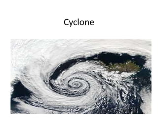
- 2. What is a Cyclone? • Cyclone is a region of low atmospheric pressure surrounded by high atmospheric pressure resulting in swirling atmospheric disturbance accompanied by powerful winds blowing in anticlockwise direction in the Northern Hemisphere and in the clockwise direction in the Southern Hemisphere. • They occur mainly in the tropical and temperate regions of the world. 2
- 3. Cyclones are known by different names in different parts of the world: • Typhoons in the Northwest Pacific Ocean west of the dateline • Hurricanes in the North Atlantic Ocean, the Northeast Pacific Ocean east of the dateline, or the South Pacific Ocean. Tropical cyclones ‐ the Southwest Pacific Ocean and Southeast Indian Ocean. • Severe cyclonic storm (the North Indian Ocean) • Tropical cyclone (the Southwest Indian Ocean) • Willie‐Willie in Australia • Tornado in South America 3
- 4. Types of Cyclones 1. Tropical cyclones: are what most people are familiar with because these are cyclones that occur over tropical ocean regions. Hurricanes and typhoons are actually types of tropical cyclones. • Hurricanes are found in the Atlantic and Northeast Pacific, typhoons are found in the Northwest Pacific. • We can also further describe tropical cyclones based on their wind speeds. They are called category 1, 2, 3, 4 or 5, increasing with intensity and wind speed as the number increases. • A category 1 cyclone is the weakest, with wind speeds of 74‐95 mph. • A category 5 cyclone, on the other hand, is extremely dangerous and has the potential for major damage. Category 5 cyclones have wind speeds of 155 mph and above! 4
- 5. 2. Polar cyclones: are cyclones that occur in Polar Regions like Greenland, Siberia and Antarctica. • Unlike tropical cyclones, polar cyclones are usually stronger in winter months. • They also occur in areas that aren't very populated, so any damage they do is usually pretty minimal. 5
- 6. 3. Mesocyclone: is when part of a thunderstorm cloud starts to spin, which may eventually lead to a tornado. 'Meso' means 'middle', so you can think of this as the mid ‐point between one type of storm and the other. • Tornadoes all come from thunderstorm clouds, but not all thunderstorm clouds make tornadoes. 6
- 7. General Characteristics: Cyclones in India are moderate in nature. Some of the general characteristics of a cyclone are: • Strong winds • Exceptional rain • Storm surge Cyclones are generally accompanied by strong winds which cause a lot of destruction. In some cases it is accompanied by heavy downpour and also the rise in the sea which intrudes inland there by causing floods. 7
- 8. The development of a cyclone covers three stages namely a) Formation and initial development state: • Four atmospheric/ oceanic conditions are necessary for the formation of a cyclone namely: – A warm sea temperature in excess of 26 degree centigrade, to a depth of 60 meters, which provides abundant water vapour in the air by evaporation. – High relative humidity – Atmospheric instability (an above average decrease of temperature with altitude) – A location of at least 4‐5 latitude degrees from the Equator allow the influence of the force due to the earth’s rotation (Coriolis force) to take effect in inducing cyclonic wind circulation around low pressure centers. 8
- 9. b) Fully matured: • The main feature of a fully mature tropical cyclone is a spiral pattern of highly turbulent giant cumulus thundercloud bands. These bands spiral inwards and form a dense highly active central cloud core which raps around a relatively calm zone. This is called the “eye” of a cyclone. The eye looks like a black hole or a dot surrounded by thick clouds. The outer circumference of the thick cloud is called the ‘eye wall’. c) Weakening or decay • A tropical cyclone begins to weaken as soon as its source of warm moist air is abruptly cut off. This is possible when the cyclone hits the land, on the cyclone moves to a higher altitude or when there is the interference of another low pressure. 9
- 10. Warning • Low pressure and the development can be detected hours or days before it causes damage. The satellites track the movement of these cyclones based on which the people are evacuated from areas lively to be affected. It is difficult to predict the accuracy. • India has one of the best cyclone warning systems in the world. The India Meteorological Department (IMD) is the nodal department for wind detection, tracking and forecasting cyclones. Cyclone tracking is done through INSAT satellite. • Cyclone warning is disseminated by several means such as satellite based disaster warning systems, radio, television, telephone, fax, high priority telegram, public announcements and bulletins in press. These warnings are disseminated to the general public, the fishing community especially those in the sea, port authorities, commercial aviation and the government machinery. 10
- 11. Effects of Cyclones and Hurricanes: • Tropical cyclones cause heavy rainfall and landslides. • They cause a lot of harm to towns and villages, causing severe damage to kuccha houses. Coastal businesses like shipyards and oil wells are destroyed. • They harm the ecosystem of the surrounding region. iv. Civic facilities are disturbed. • Agricultural land is severely affected, especially in terms of water supply and soil erosion. • It causes harm to human, plant and animal life. • Communication systems are badly affected due to cyclones. 11
- 12. Typical Adverse effect: • First, in a sudden, brief onslaught, high winds cause major damage to infrastructure and housing, in particular fragile constructions. • They are generally followed by heavy rains and floods and, in flat coastal areas by storm surge the land over long distances of even upto 15 kilometer inland damaged or destroyed by the wind force, flooding and storm surge. • Light pitched roofs of most structures especially the ones fitted on to industrial buildings will suffer severe damage. 12
- 13. • Casualties and public heath – caused by flooding and flying elements, contamination of water supplies may lead to viral outbreaks, diarrhea, and malaria. • Water supplies – Ground and pipe water supply may get contaminated by flood waters. • Crops and food supplies – high winds and rains ruin the standing crop and food stock lying in low lying areas. Plantation type crops such as banana and coconut are extremely vulnerable. Salt from the sea water may get deposited on the agricultural land and increase the salinity. The loss of the crop may lead to acute food shortage. • Communication – severe disruption in the communication links as the wind may bring down the electricity and communication towers, telephone poles, telephone lines, antennas and satellite disk and broadcasting services. Transport lines (road and rail) may be curtailed, Lack of proper communication affects effective distribution of relief materials. 13
- 14. Management and Mitigation of Cyclones and Hurricanes: • Coastal areas should be well prepared to meet eventualities that arise from cyclones. • Houses should be constructed such that they can withstand the heavy rainfall and forceful winds. • Shelter belts should be created to check soil erosion and speed of winds. • Remote sensing techniques should be used to forecast cyclones appropriately. v. When a cyclone does occur, rescue and relief operations should be in place. 14
- 15. • Possible Risk Reduction Measures: • Coastal belt plantation ‐ green belt plantation along the coastal line in a scientific interweaving pattern can reduce the effect of the hazard. Providing a cover through green belt sustains less damage. Forests act as a wide buffer zone against strong winds and flash floods. Without the forest the cyclone travel freely inland. The lack of protective forest cover allows water to inundate large areas and cause destruction. With the loss of the forest cover each consecutive cyclone can penetrate further inland. • Hazard mapping – Meteorological records of the wind speed and the directions give the probability of the winds in the region. Cyclones can be predicted several days in advance. Past records and paths can give the pattern of occurrence for particular wind speeds. A hazard map will illustrate the areas vulnerable to cyclone in any given year. It will be useful to estimate the severity of the cyclone and various damage intensities in the region. The map is prepared with data inputs of past climatological records, history of wind speed, frequency of flooding etc. 15
- 16. • Land use control designed so that least critical activities are placed in vulnerable areas. Location of settlements in the flood plains is at utmost risk. Policies should be in place to regulate land use and building codes should be enforced. • Engineered structures – structures need to be built to withstand wind forces. Good site selection is also important. Majority of the buildings in coastal areas are built with locally available materials and have no engineering inputs. Good construction practice should be adopted such as: • Cyclonic wind storms inundate the coastal areas. It is advised to construct on stilts or on earth mound. • Houses can be strengthened to resist wind and flood damage. All elements holding the structures need to be properly anchored to resist the uplift or flying off of the objects. For example, avoid large overhangs of roofs, and the projections should be tied down. • A row of planted trees will act as a shield. It reduces the energy. 16
- 17. • Buildings should be wind and water resistant. • Buildings storing food supplies must be protected against the winds and water. • Protect river embankments. • Communication lines should be installed underground. • Provide strong halls for community shelter in vulnerable locations. 17
- 18. 18
- 19. • Flood management – Torrential rains strong wind and storm range leads to flooding in the cyclone affected areas. There are possibilities of landslides too. Flood mitigation measures could be incorporated • Improving vegetation cover – The roots of the plants and trees keep the soil intact and prevent erosion and slow runoff to prevent or lessen flooding. The use of tree planted in rows will act as a windbreak. Coastal shelter belt plantations can be developed to break severe wind speeds. It minimizes devastating effects. • Shelterbelt plantation species chosen for this purpose should not only be able to withstand the impact of strong cyclonic winds, but also check soil erosion. 19