SSA 2012 Presentation: Extraordinary Weather and Extreme Soaring Flights
•
1 j'aime•2,071 vues

Here's a presentation by Prof. Emeritus Dr. Edward (Ward) Hindman of the Earth and Atmospheric Science Dept., The City College of New York, NY USA Presented at the U. S. Soaring Society of America (SSA) Convention in Reno NV on February 2, 2012

Recommandé
Recommandé
Contenu connexe
En vedette
Similaire à SSA 2012 Presentation: Extraordinary Weather and Extreme Soaring Flights
Similaire à SSA 2012 Presentation: Extraordinary Weather and Extreme Soaring Flights (20)
Plus de Glider Pilot
Plus de Glider Pilot (20)
Dernier
Dernier (20)
SSA 2012 Presentation: Extraordinary Weather and Extreme Soaring Flights
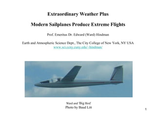
- 1. Extraordinary Weather Plus Modern Sailplanes Produce Extreme Flights Prof. Emeritus Dr. Edward (Ward) Hindman Earth and Atmospheric Science Dept., The City College of New York, NY USA www.sci.ccny.cuny.edu/~hindman/ Ward and ‘Big Bird’ Photo by Baud Litt 1
- 2. This unique 3.5 minute video highlights the beauty and grace of soaring flight. The video was shot by Daniel Ramseier from an alpine peak near Dent de Broc during the 2004 Swiss National Championships. The alluring background voice is Enya’s Enjoy! 2
- 3. Talk Content Rising air makes a glider a sailplane Main sources of rising air for cross-country flying: thermals, ridge winds and mountain waves An extreme thermal flight, Hobbs NM, June 2011 [18m Nationals] An extreme ridge flight, Julian PA, April 2010 [TS 34(4)] An extreme wave flight, Argentina, November 2003 [TS 35(3 & 4)] 3
- 4. Rising air makes a glider a sailplane ‘Thrust’ www.grc.nasa.gov/WWW/K-12/airplane/glidfor.html 4
- 5. Rising air makes a glider a sailplane Glider forward speed ‘Thrust’ Glider sinking speed Rising air < Sinking speed = gliding flight Rising air > Sinking speed = soaring flight 5
- 6. Sources of rising air: thermals, ridge winds and mountain waves From Liechti and Hindman (editors), 2009: Weather Forecasting for Soaring Flight, 6 World Meteorological Organization - No. 1038, 70 pp.
- 7. An extreme thermal flight at the Soaring Society of America’s 18m Nationals, 26 June 2011, Hobbs NM ‘A8 and his gazelle Brenda’ From www.ssa.org, Sailplane Racing Results and Reports 7
- 8. An extreme thermal flight The morning weather forecast required to set the afternoon’s task: Winds at the surface and aloft Clouds and precipitation Convective boundary layer characteristics: depth and expected lift Thunderstorms Task Results 8
- 9. Winds, clouds and precipitation Aviation Forecast from the National Weather Service: KHOB 261120Z 2612/2712 18005KT P6SM SKC FM261600 20012KT P6SM SKC From aviationweather.gov/adds/, TAF for KHOB (Hobbs/Lea County) Civilian Forecast from the National Weather Service: 0312MDT SUN 26 JUN 2011: SUNNY. HIGHS AROUND 108. SOUTHWEST WINDS 10 TO 15 MPH From www.weather.unisys.com, Local_Forecast (88240, Hobbs NM) 9
- 10. Winds, clouds and precipitation 10 From www.weather.unisys.com, Satellite_Surface
- 11. Winds, clouds and precipitation 11 From www.weather.unisys.com, Upper Air Data/700mb
- 12. Winds, clouds and precipitation 12 From www.weather.unisys.com, NAM/WRF Model
- 13. Convective boundary layer characteristics 13 From www.arl.noaa.gov/ready/cmet.html, HOB (32.7N 103.1W), Meteorogram
- 14. Convective boundary layer characteristics 14 From www.arl.noaa.gov/ready/cmet.html, HOB, Sounding
- 15. Convective boundary layer characteristics 15 From www.xcskies.com, Top-of-usable lift.
- 16. Thunderstorms 16 From www.xcskies.com, Lifted index.
- 17. Task 4.5 hours minimum time on course with 360 miles of required turn-points (Min: 172 miles, Max: 511 miles) 17
- 18. Results (www.ssa.org Sailplane Racing/Results and Reports) “7V (70+ year-old Ray Gimmey) smoked the field with 465 miles at 103 mph” 4hr 32min time on course; 23% circling flight, 77% straight flight 18
- 19. Results “7V (70+ year-old Ray Gimmey) smoked the field with 465 miles at 103 mph” 4hr 32min time on course; 23% circling flight, 77% straight flight 19
- 20. Results The ‘round, firm, and fully-packed’ cumulus > 1000 fpm climb passing through FL170 20
- 21. An extreme ridge flight that originated from Julian PA on 28 April 2010 Julian PA Appalachian Ridge and Valley System From Wikipedia 21
- 22. An extreme ridge flight The pilot, 22-year old Devin Bargainnier flying a Ventus 2b, planned the flight because a cold front associated with a powerful low pressure system was expected to produce favorable winds for a large portion of the Appalachian ridge system between Williamsport PA and Knoxville TN. Further, the forecasts for cloud cover and precipitation for stations along the route were acceptable. He did not utilize the experimental thermal, ridge and wave forecast system we - the German Weather service, the system’s creator Dr. Olivier Liechti and me - made available to northeast USA glider pilots during the 2010 soaring season. He was not aware of its existence. Had he used the system, this is what he would have learned. 22
- 23. The forecast system The forecast system is called Java TopTask. The system is operational in Europe through the German Weather Service and is described in Technical Soaring. Briefly, the system is based on numerical weather predictions of winds, clouds, precipitation, convective boundary layer characteristics and ridge and wave lift. The TopTask algorithm ‘flies’ a glider through the predicted weather to determine the feasibility of a proposed task. After the flight, the predicted weather can be validated by ‘flying’ the actual flight trajectory through the prediction. 23
- 24. Thermal lift forecast 24
- 25. Ridge lift forecast 25
- 26. Proposed task 26
- 27. Actual task 27
- 28. Validation of the forecast for thermal and ridge lift 1714 km, 155 kph 1741 km, 142 kph 28
- 29. Validation of the forecast for wave lift 29
- 30. An epilogue Pilots participating in the experiment provided positive and encouraging evaluations. Consequently, Dr. Liechti and I attempted to make the JavaTopTask forecast system available the 2011 soaring season. The system needed to be connected to an operational USA numerical weather prediction model to replace unavailable German model. No connection was made because the necessary expert could not be found. Hence, the system was and remains unavailable. Baud Litt reported in the recent issue of the National Soaring Museum Journal pioneering long-distance flights in convective, ridge and wave lift during the winter of 2010-11 similar to the flight simulated here. Baud’s flights originated from Fairfield PA in the Appalachian Ridge and Valley System. Had the system been available to study Baud’s flights, the TopTask algorithm would have benefitted especially the wave portion. 30
- 31. The world-record, straight-line wave flight of 2138 km (1188 smi)) from El Calafate to San Juan, Argentina on 23 November 2003 Nimbus 4DM From www.wolframjust.de/Nimbus_4DM.html 31 The Route From maps.google.com
- 32. An extreme wave flight The weather forecast required to set the task was provided by the Mountain Wave Project team (www.mountain-wave-project.com): Winds aloft Clouds and precipitation Wave lift 32
- 33. Winds aloft The Polar Front Jet Stream and the Subtropical Jet Stream were juxtaposed ‘hosing down’ the maximum length along the Andes. 33
- 34. Clouds and precipitation Altocumulus standing lenticular clouds above and rotor clouds below mark the wave. The clouds were too thin to produce precipitation. From Liechti and Hindman (editors), 2009: Weather Forecasting for Soaring Flight, WMO-No. 1038, 70 pp. 34
- 35. Wave lift ‘Read’ the clouds to locate the lift 35 From Liechti and Hindman (editors), 2009: Weather Forecasting for Soaring Flight, WMO-No. 1038, 70 pp.
- 36. Flight: 2138 km (1188 mi), 14.5h, 147kph (82mph), 10% circling & 90% straight ‘we had to climb to see “Mendoza D-KAHG buenos dias, para transitar the foehn gaps and rotor en su zona al nivel de vuelo 245?” “Do you have clouds that marked the a sqwak HG?” “Negative”. “Then report to 2,000 ideal path’ ft overhead the airfield…” “Please, I’m flying a world record. Can I fly to the west, via the 36 Laguna Diamante?” To my relief, she conceded, ‘0525 LT departed El Calafate’ but only to an altitude of FL 195 (6,000 m). ‘2000 LT arrived San Juan’
- 37. OSTIV-AWARD Joachim P. Kuettner Prize and Trophy for a 2500 km free, straight distance soaring flight ‘Since it is considered possible to achieve the 2500 km free straight distance in soaring flight with high performance sailplanes by using only meteorological power sources such as waves, cloud streets, slope winds etc. combined with meteorological navigation and flight techniques, OSTIV continues to comply with the wish of the late Dr. Joachim Kuettner to set up a prize and trophy for the first flight over the 2500 km free, straight distance.’ From Technical Soaring, 35(3), 2011 37
- 38. Talk Content Rising air makes a glider a sailplane Main sources of rising air for cross-country flying: thermals, ridge winds and mountain waves An extreme thermal flight, Hobbs NM, June 2011 [18m Nationals] An extreme ridge flight, Julian PA, April 2010 [TS 34(4)] An extreme wave flight, Argentina, November 2003 [TS 35(3 & 4)] 38