Cloud Frontiers: A Deep Dive into Serverless Spatial Data and FME
Hong Yang p1 presentation
1. P1/01-11-2011/ TUDelft/ Name: Hong Yang/ Student nr. 4121139/ e-mail: H.Yang-3@student.tudelft.nl/ graduation studio: Complex City
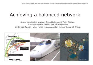
Achieving a balanced network
Governmental Plan
A new developing strategy for a High-speed Train Station,
emphasizing the Social-Spatial Integration
in Beijing-Tianjin-Hebei mega region corridor, the northeast of China.
Ecological belt
Chengde
Zhangjiakou
Beijing-Tianjin Corridor
Qinhuangdao
Beijing
Tangshan
Langfang Tianjin
Baoding
Binhai Coastal
economic belt
Cangzhou
Shijiazhuang
Hengshui
Xingtai
Traditional industry belt
Handan
0 24 10 20km
0 100 200 300km
2. Motivation Ecological belt
Zhangjiakou
Chengde
Beijing-Tianjin Corridor
Contradiction 1: Beijing
Qinhuangdao
Tangshan
Langfang Tianjin
A new high-speed train station will be located in Binhai Baoding
Binhai Coastal
New District - an strategic new city in Beijing-Tianjin- Cangzhou
economic belt
Hebei mega region. From the two newest versions of Shijiazhuang
Hengshui
governmental plan, its potential impact on the local Xingtai
fig01. Second stage of Beijing-Tianjin-
Traditional industry belt
development is far from fully exploration. Handan
Heibei Regional Strategy Plan
Sources: (by Wu. The second report of research on rural & urban
development planning for Beijing-Tianjin-Hebei, 2006)
0 100 200 300km
?
?
?
?
0 48
0 4 8 20
20 40km
40km 0 48
0 4 8 20
20 40km
40km
fig02. HST station area in 2005 Tianjin Master Plan for 2020 fig03. HST station area in 2006 Binhai Master Plan for 2020
Sources: (Tianjin Master Plan, 2005) Sources: (Binhai Master Plan, 2006)
3. Motivation
Contradiction 2:
The current development in the mode of setting large monofunctional industry parks in Binhai New District, has
raised a series of urban issues: functional segregation, high energy cost, low living quality. In the newest version of
governmental plan, the problems have not been addressed to solve or lease.
In-between
Tianjin Binhai
fig04. Image of working and living separately
Sources: (by the author, 2011)
4. Motivation
Based on the above two contradictions, the motivation of the graduation project is to use
the HST station as an opportunity to find a proper development mode for Binhai New
District.
The methodology could also be applied to the other areas/cities in a rapid developing
region.
5. Location and Content
Area:
Beijing-Tianjin-Hebei Region is located in the 183,700 km2
northeast of China. It is the third biggest coastal city region Population:
following Yangtze River Delta and Pearl River Delta. It is the China Yangtze River
Delta
76,000,000
most dynamic node in Bohai Sea Rim, also play a key role in
Pearl River
Northeast Asia. Delta
Beijing-Tianjin
-Hebei Region
Beijing and Tianjin are two main cities in this region and
they are surrounded by eleven small cities in Hebei province. Area:
11,920 km2 (Beijing: 16,800 km2)
The distance between the two cities is only 120 km.
Beijing Population:
12,900,000 (Beijing: 19,600,000)
Heibei
Distance from Beijing:
120km
Binhai New District is a vice-province district in Tianjin. 0 100 200 300km
Tianjin
It is located in the east coastal area of Tianjin. It was set
Area:
up as a national economic development district. The GDP of 2,270 km2 (19% of Tianjin)
it in 2010 has been the half of Tianjin, beyond Pudong New
District in Shanghai. Population:
2,300,000 (17.8% of Tianjin)
GDP:
371billion yuan (51% of Tianjin)
Employment:
368,500 (18% of Tianjin)
Distance from city centre:
40km
0 20 40 60km
Binhai New District
fig05. Location in national, regional and city scale
Sources: ( Google map & the author, 2011)
6. Background
Beijing-Tianjin-Hebei Mega Region Beijing-Tianjin Corridor
The region: In the second phase of regional plan for Beijing-Tianjin-
-A polycentric metropolitan region Hebei. A new pattern as “One axis, three belts” was
-The hinterland of Beijing linking resource, market and mentioned to improve the regional development balance.
space.
Tianjin: The expansion of “Beijing-Tianjin Corridor” meets “Coastal
-The Second city, a traditional industry city. economical belt” at Binhai New District, which highlights
Binhai New District the role of Binhai New District in the regional level.
-The most important port in the region (the third in
China), which is Beijing lack of.
The regional cooperation is still in starting stage. Ecological belt
-Core cities have not bring more opportunities to the Chengde
hinterland. Zhangjiakou
-regional resource has not given sufficient support to Beijing-Tianjin Corridor
core cities.
Qinhuangdao
Beijing
Tangshan
Gross Regional Product, 2009 Langfang Tianjin
Chengde
14000.00 Zhangjiakou Baoding
Unit: 100,000,000 yuan
12000.00
10000.00
Beijing
Qinhuangdao
Binhai Coastal
economic belt
Tangshan
8000.00 Langfang
Tianjin
6000.00
Baoding Cangzhou
4000.00
Cangzhou
2000.00 Shijiazhuang Shijiazhuang
0.00 Hengshui
Xingtai
Hengshui
Handan Xingtai
fig06. Gross regional product 0 100 200 300km Traditional industry belt
Sources: ( Chinese regional economic year book, 2010, by the author, 2011) Handan
0 100 200 300km
fig07. Second stage of Beijing-Tianjin-Heibei Regional Strategy Plan
Sources: (by Wu. The second report of research on rural & urban development planning for Beijing-
Tianjin-Hebei, 2006)
7. Background
Regional Infrastructure
The new high-speed train system in the region pushes
forward the formation of network in hard infrastructure,
as the backbone of regional cooperation network. The
resource sharing and industry chain reconstruction gio
n
Re
gradually starts. nin
g
ao
Li
h
ut
So
Two important high-speed railways, Beijing-Tianjin intercity
railway and Tianjin-Qinhuangdao railway meet at Binhai
New District. The existing Tianjin-Binhai metro line also
has improved the mobility along Beijing-Tianjin corridor.
Besides, a plan for a Beijing Second Airport is still under- Bohai Sea
discussion to lease the stress of Beijing Airport. To use
the existing Tianjin Airport (between Tianjin and Binhai)
effectively is also another proposed option.
to
Ya
High-speed railway
n
gt
High-speed railway
ze
under construction
Ri
ve
r
Metro
De
lta
0 48
0 40 20
100 40km
200km
g
an
hu
ng
ng
az
di
iji
i ji
o
ao
Be
Sh
Ba
gd
n
ha
an
ai
in
gs
hu
nh
nj
0.5h 0.5h 0.5
n
in
Bi
a
Ta
h
Q
Ti
0.25h 0.5h 0.5h
ai
6h
gh
an
Sh
fig08. High-speed train system in Beijing-Tianjin-Hebei
Sources: ( by the author, 2011)
8. Background
Regional mode
Ecology belt Ecology belt
The mobility is reforming the mode of the region. Beijing-Tianjin Corridor Beijing-Tianjin Corridor
Binhai New District is becoming an essential node both on
hard network and flow of resource and market.
Coastal Coastal
economic belt economic belt
Ecologic belt Ecologic belt
Formal region mode New region mode
fig09. Abstraction of regional mode
Sources: (by the author, 2011)
Beijing Tianjin Binhai
Traditional role Core in all Industry city Port
Restructuring
Industry
Role in network Service core
? Sub-core
? Manufactory core
?
fig10. Doubting of role in network
Sources: (by the author, 2011)
9. Background
Industry Restructuring
Since Beijing turned to focus on developing the tertiary industry, it
has launched a massive industry relocation. During last 20 years,
Beijing has move most its formal large factories in secondary
industry to its surrounding areas in Beijing-Tianjin-Heibei Region.
Tianjin, as the second biggest economic sector in the region,
became the main receiving zone.
>70%
50% - 70%
40% - 50%
30% - 40%
20% - 30%
2002 2009
fig12. Rate of the tertiary industry in GDP, in Beijing-
Tianjin-Hebei region
Sources: (Chinese regional economic year book, 2003&2010, by the author, 2011)
Gross Regional Product, 2009
Chengde
14000.00 Zhangjiakou
Unit: 100,000,000 yuan
12000.00
Beijing
10000.00 Qinhuangdao
Tangshan
8000.00 Langfang
Tianjin
6000.00
Baoding
4000.00
Cangzhou
2000.00 Shijiazhuang
0.00 Hengshui
Xingtai >60%
50% - 60%
Handan 30% - 50%
20% - 30%
2002 2009 0 - 20%
0 100 200 300km
fig13. Rate of the secondary industry in GDP, in
fig11. Gross regional product of Beijing-Tianjin-Hebei Beijing-Tianjin-Hebei region
Sources: ( Chinese regional economic year book, 2010, by the author, 2011) Sources: (Chinese regional economic year book, 2003&2010, by the author, 2011)
10. Background
Industry Restructuring
The similar process also happened inside Tianjin itself: the
inner city depends on the well linkage with Beijing, also get
more opportunity to take part in tertiary industry and strives
to consolidate its role as service and culture centre of Tianjin.
Therefore, it also needs to move the secondary industry out for
more available land.
To achieve this, Binhai New District was established in 1994
by Tianjin municipality. The formal rural salt lick has been >70%
the most important sector in Tianjin's economy, mainly on the
50% - 70%
40% - 50%
secondary industry.
30% - 40%
20% - 30%
1993 2009
Gross Domes c Product of Tianjin, 1993
500
fig15. Rate of the tertiary industry in GDP, in Tianjin
Sources: (Tianjin economic year book, 1994&2010, by the author, 2011)
Unit: 100,000,000 yuan
400
300 Primary Industry
200
Secondary Industry
100
Ter ary Industry
0
Innercity Suburban Coun es Binhai New
District
Gross Domes c Product of Tianjin,
2009 Counties
3000
2500
Unit: 100,000,000 yuan
2000
Primary Industry Innercity
1500 Binhai New District
Secondary Industry Suburban
1000 >60%
Ter ary Industry 50% - 60%
500 Counties 30% - 50%
20% - 30%
0
Innercity Suburban Coun es Binhai New 0 - 20%
District 0 20 40 60km
1993 2009
fig14. GDP of Tianjin, 2008 fig16. Rate of the secondary industry in GDP, in Tianjin
Sources: ( Tianjin economic year book, 2008, by the author, 2011) Sources: (Tianjin economic year book, 1994&2010, by the author, 2011)
11. Background
Industry Restructuring
The restructuring of industry is not only in the single direction. This
relocation in Binhai was started with setting several industry parks.
With the new industry gathering, more business service related
to these industries appeared around the industry parks. The
opportunity for new business centre comes in following.
>70%
50% - 70%
40% - 50%
30% - 40%
20% - 30%
2002 2009
fig18. Rate of the tertiary industry in GDP, in Binhai
Sources: (Binhai economic year book, 1994&2010, by the author, 2011)
Hangu
Binhai Hi-tech
Gross Domestic Product of Binhai New District, 2009 TEDA
1200.00 TPFTZ
Tanggu
1000.00
Unit: 100,000,000 yuan
800.00
600.00
Primary Industry
400.00 Secondary Industry
Tertiary Industry Dagang
200.00 >60%
50% - 60%
0.00 30% - 50%
Tanggu Han'gu Dagang TEDA TPFTZ Binhai Hi- 20% - 30%
tech
0 10 20 30km 0 - 20%
2002 2009
fig17. GDP of Binhai, 2008 fig19. Rate of the secondary industry in GDP, in Binhai
Sources: ( Binhai economic year book, 2008, by the author, 2011) Sources: (Binhai economic year book, 1994&2010, by the author, 2011)
12. Background
Industry Restructuring
I describe the process by using the Dupuy's definition of place in network and Sassen' view in global city:
- Absolute high level and low level has disappeared in the network. Service and industry did not separate simply in
space (Dupuy, 2008).
- They distribute in network in a kind of interactive balance (Dupuy, 2008).
- Dynamic high-tech development department also includes low-income position. Backward sectors, such as the
degraded manufacture or low-paid service, are maybe the most important sectors in rapid development (Sassen,
1991).
- The place in the low-level economic activity sometimes is another kind of highly specialized centre (Sassen, 1991).
13. Problem field
Regional Problem
-No concrete relationship between regional plan and local governmental master plan.
-HST station has not been considered as an opportunity to restructure the surrounding urban area, even less in social-
spatial integrated potentiality.
?
?
?
?
0 48
0 4 8 20
20 40km
40km 0 48
0 4 8 20
20 40km
40km
fig20. HST station area in Tianjin Master Plan for 2020 fig21. HST station area in Binhai Master Plan for 2020
Sources: (Tianjin Master Plan, 2005) Sources: (Tianjin Master Plan, 2006)
14. Problem field Ecological belt
Governmental
City master plan Plan
Chengde
Zhangjiakou
Beijing-Tianjin Corridor
Qinhuangdao
Beijing
Existing urban structure: Duo-centre mode with several fragments in in-between area, in these Tangshan
fragments, segregations existed in all aspects - spatial, economy, social, environment.
Langfang Tianjin
Baoding
Binhai Coastal
economic belt
Cangzhou
Governmental proposal and tools Shijiazhuang
-To full fill the corridor by simply enlarging pieces of fragments to clusters, but keep the
Hengshui
Xingtai
monofunctional mode without expressing as a linking structure. Traditional industry belt
-To control the developments, to leave the possibility for the future development and the access
Handan
to regional landscape, by setting green belt between monofunctional industry clusters. 0 100 200 300km
fig22. Existing spatial structure of Tianjin fig23. Planned spatial structure of Tianjin for 2020
Sources: (Tianjin Master Plan, 2005, by the author, 2011) 0 24 10 20km Sources: (Tianjin Master Plan, 2005, by the author, 2011) 0 24 10 20km
15. Problem field
Urban reality
1. Monofunctional industry fragments: 2. Separation between living and working
Workers cannot use the area. Rural inhabitants cannot -traffic congestion
get benefits from the factory. -high energy cost
-high time cost, low quality of life for commuting groups
Workers in Binhai New District, 2009
live in Binhai
273 000
travel by metro
350,000
travel by bus
travel by shuttle or car
31,500
45,500
fig24. Industry typology in the in-between corridor fig26. The rate of traffic mode of workers in Binhai
Sources: (Google map, 2011) Sources: (Population plan of Binhai, 2009, Binhai economic year book, 2010, by the author, 2011 )
fig25. Factory in the in-between corridor fig27. Traffic congestion between Tianjin and Binhai
Sources: (Google map, 2011) Sources: (http://tianjinwe.com, 2011)
16. Problem field
In-between
Tianjin Binhai
fig28. Image of working and living separately
Sources: (by the author, 2011)
17. Problem field
Policy feature of fast-developing economic development zone
-Less policy restrict
-Less application period
-Local municipality has high autonomy rights
Land-use feature of economic development zone
-High uncertainty
-Loose land-use, reserved land for future development
-Market-oriented, most function is only for industry. Service offering is less.
Plan feature of economic development zone
-Offer mass of available lands, no hierarchy.
-Similar function planned in different projects.
-Quickly made to attract investment
-Service facilities are planned but delay to implement due to market-oriented content.
18. Problem field Ecological belt
Zhangjiakou
Chengde
Beijing-Tianjin Corridor
The governmental local plan Beijing
Qinhuangdao
Tangshan
Langfang Tianjin
Baoding
Binhai Coastal
economic belt
Cangzhou
Shijiazhuang
Hengshui
Xingtai
Traditional industry belt
Handan
0 24 10 20km 0 24 10 20km
0 100 200 300km
0 4 16
0 8 8 20
40 40km
80km 0 4 16
0 8 8 20
40 40km
80km
fig29. Existing situation of the corridor and centre of Binhai fig30. Planned the corridor and centre of Binhai for 2020
Sources: (Tianjin Master Plan, 2005) Sources: (Tianjin Master Plan, 2005)
19. Problem field
Evaluate the governmental plan
Land-use: Just start to solve the problem in existing industry park by adding housing around it, but to continue the
monofunctional structure in new industrial development, leaving more problem for future.
living/service green belt sea highway living/service green belt sea highway
industry park railway industry park railway planned highway
port/airport river/lake train station port/airport river/lake train station
0 4 16
0 8 8 20
40 40km
80km 0 4 16
0 8 8 20
40 40km
80km
0 24 10 20km
fig31. Existing situation of the corridor and centre of Binhai fig32. Planned the corridor and centre of Binhai for 2020
Sources: (Tianjin Master Plan, 2005, by the author, 2011) Sources: (Tianjin Master Plan, 2005, by the author, 2011)
20. Problem field
Evaluate the governmental plan
Land-use in projects:
Similar massive projects were set together. There is no strategy hierarchy in plan. The areas in city compete for
investment and internal market with each other, without collaboration and correlation.
Airport Logistic
Industry Park
Eco-city
Hi-tech
Industry Park Binhai Station
Modern Metallurgy
Industry Park
Yujiabu Station & CBD
Port Industrial Park
University City
0 4 16
0 8 8 20
40 40km
80km
fig33. New projects the corridor and centre of Binhai for 2020
Sources: (Tianjin Master Plan, 2005, by the author, 2011)
0 24 10 20km
21. Problem field
Evaluate the governmental plan
Infrastructure:
Road system-Still mainly focus on goods delivery at regional level.
living/service green belt railway main road train station living/service green belt railway main road train station
industry river/lake highway metro line metro industry river/lake highway metro line metro
park sea park sea planned planned
highway metro line
0 24 10 20km
0 4 16
0 8 8 20
40 40km
80km 0 4 16
0 8 8 20
40 40km
80km
fig34. Existing infrastructure of the corridor and centre of Binhai fig35. Planned infrastructure of the corridor and centre of Binhai for 2020
Sources: (Tianjin Master Plan, 2005, by the author, 2011) Sources: (Tianjin Master Plan, 2005, by the author, 2011)
22. Problem field
Evaluate the governmental plan
Infrastructure:
Metro system-Several regional important nodes are overlapped by public transportation.
Conclusion:
Transportation facilities focus on the accessibility of the regional driving force.
Eco-city
?
Binhai Station
Binhai Centre
Yujiabu Station & CBD
Port Industrial Park
0 4 16
0 8 8 20
40 40km
80km
fig36. Overlap of infrastructure and regional driving force
Sources: (Tianjin Master Plan, 2005, by the author, 2011) 0 24 10 20km
23. Problem field
Evaluate the governmental plan
Landscape:
Without considering existing and planned land-use and infrastructure.
Be combined with infrastructure, low integration with surrounding area in function, more like boundaries.
? Eco-city
?
Binhai Station
?
Binhai Centre
Yujiabu Station & CBD
Port Industrial Park
0 4 16
0 8 8 20
40 40km
80km
fig37. Planned landscape of the corridor and centre of Binhai for 2020
Sources: (Tianjin Master Plan, 2005, by the author, 2011) 0 24 10 20km
24. Problem Statement
There are two main problems on the government plan.
On one hand, the governmental plan does not solve the existing segregation in the in-between corridor.
-It only enlarges the monofunctional industry area.
-It does not consider the functional and social segregation in the in-between corridor.
-It does not consider the hierarchy between projects and areas.
On the other hand, the governmental plan does not recognise the impact and opportunity from the regional high-
speed train station.
-It could be an opportunity to restructure the in-between corridor and landscape for its strategic location.
-It could be an opportunity to give a hierarchy to solve functional and social segregation by its priority as a regional
infrastructure.
25. Problem Statement
Problem framework
Beijing Tianjin Binhai Regional Driving force
Traditional role Core in all Industry city Port Port
Restructure
Industry
Manufactory core Industry Park
Sub-service core
Role in network Service core
R&D core
Specific service core CBD
Central node Joint node Joint node HST Station
Role on mobility
Main Airport Associated Airport Airport Integrated
Plan
Local influence Local Challenge
Labour Housing
Service
Public
transportation
fig38. Problem framework
Sources: (by the author, 2011)
26. Research Question
Main research question:
How to use the regional high-speed train station as a new centrality to improve the spatial and social integration in
the surrounding industry area?
Sub-research question:
-What are the potential functions in high-speed station node relate to the industry area?
-What is the possible mix-functional land use mode in labour intensive industry development area?
-What is the potential network for commuters to participate into social activities?
-What is the possible strategy to offer the accessible housing to workers near their working place in the market orient-
ed content?
-What is the potential role for the greenbelt as the linkage of urbanization and the regional park instead of a bound-
ary?
27. Methodology
Empirical study
Research tool
Beijin-Tianjin-Hebei mega region
Data research Beijing-Tianjin Corridor
Policy reflection Regional Infrastructure
Mapping Polycentric development
Governmental regional strategy Governmental local plan
Evaluation
Criteria
Land use
HST station plan Infrastructure Existing local problem
Landscape
P1 & P2
Gap Gap
Problem statement
Research question
Research tool Empirical Study Theory Study
Data research Amsterdam central station New city-Region
Mapping Rotterdam central station Regional development
Globalization
Polycentric urban region
Splintering urbanism
Planning into fragmented society
The Regeneration power of train station
development
Guide principle
P3
Polycentric region
Local development
Station development Suggestion for
Output
improvement
P4
New Strategy
HST station
Surrounding area
P5
Testing design
fig39. Phasing and time-schedule
Sources: (by the author, 2011)
28. Theory related
Theory Author/Expert
New city-region Network theory Dupuy, G.
Regional development
Globalization
Splintering urbanism Graham, S. & Marvin, S.
The Regeneration power of train station development Bertolini, L.
Polycentric urban region Zonneveld, W.
Planning into fragmented society Healey, P.
29. Case study
Rotterdam Central Station area and Amsterdam Central Station area
The survey will explore:
How do key station projects function to structuring the development of surrounding area?
How do they integrate the regional investment into local interests?
How do they react to the existing and potential social-spatial segregation?
fig40. Rotterdam central station project fig41. Amsterdam central station project
Sources: (West 8,http://www.west8.nl/projects/rotterdam_centraal_station/, 2011) Sources: (Benthem Crouwel, http://www.stationseiland.amsterdam.nl/, 2011)
30. Relevance
Social relevance
The paper gives an emphatic attention to a special group during the process of industry restructuring and relocation -
commuters. They are the harmed agency in the polycentric developing process. They have to leave their home early
and get back late. They are isolated during the daytime in their factory and journey in shuttle bus. This high time cost
makes them separated from their society and their family.
Because commuters still have a job and basic housing, they are still less discussed in China. However, the group is
extremely huge for the labour – intensive industry developing level of China. High pressure, increasing divorce rate,
more and more dink families and increasing Juvenile rate are common among them. They need to be concerned and
addressed by planners.
Scientific relevance
There are a certain amount of previous research and practice tried to find a suitable pattern for the suburban sprawl
like T.O.D. (Transit Oriented Development). However, most of them have been proved not suitable to Chinese cities for
the differences in city size, economic level and decision making system. The supported service, facilities will only ap-
pear if there is sufficient market and volumes of demand (Marcuse, 2008), especially under the neo-liberal economic
policy system. The similar situation also happened in implementation of social housing policy.
On the other land, the national government own absolute controlling force on large national and regional projects. In-
vestments and resource can be mustered in short time. Whether there is a way for planners to integrate some facili-
ties offering development with these large projects to achieve more than economic return, will be explore in the pa-
per.