Bamyan - Home of Ancient Buddhas
•Télécharger en tant que DOCX, PDF•
0 j'aime•414 vues

Bamyan-Afghanistan
![34°49′N 67°49′E
Country Afghanistan
Province Bamyan Province
Elevation 2,550 m (8,370 ft)
Population (2006)
• City 61,863
• Urban 39,915[1]
Time zone UTC+4:30
Bamyan[pronunciation?] (Persian: بامیان Bāmyān), also spelled Bamiyan[2] and Bamian,[3] is the
capital of Bamyan Province in central Afghanistan. With an altitude of about 2,550 m and with a
population of about 61,863, Bamyan is the largest town in the central Afghan region of
Hazarajat, and lies approximately 240 kilometres north-west of Kabul, the national capital.
Bamyan was the site of an early Hindu–Buddhist monastery from which Bamyan takes its name
(Sanskrit varmayana, "coloured"). Bamyan's name is translated as ‘The Place of Shining
Light’.[4] Many statues of Buddha are carved into the sides of cliffs facing Bamyan city. In 2008,
Bamyan was found to be the home of the world's oldest oil paintings.[5] The city of Bamyan has a
population of 39,915 (in 2015). [6] it has 4 districts and a total land area of 3,539 Hectares. [7] The
total number of dwellings in this city are 4,435 .[8]
The Bamiyan valley marked the most westerly point of Buddhist expansion and was a crucial
hub of trade for much of the second millennium CE. It was a place where East met West and its
archaeology reveals a blend of Greek, Turkish, Persian, Chinese and Indian influence.
Contents
1 Geography
2 Climate
3 History
o 3.1 Buddhas
o 3.2 Demography
o 3.3 Land Use
4 See also
5 Notes
6 References
7 Sister Cities
8 External links
Geography](data:image/gif;base64,R0lGODlhAQABAIAAAAAAAP///yH5BAEAAAAALAAAAAABAAEAAAIBRAA7)
Recommandé
Contenu connexe
Tendances
Tendances (17)
Similaire à Bamyan - Home of Ancient Buddhas
Similaire à Bamyan - Home of Ancient Buddhas (20)
Dernier
Dernier (20)
Bamyan - Home of Ancient Buddhas
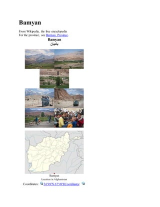
- 1. Bamyan From Wikipedia, the free encyclopedia For the province, see Bamyan Province. Bamyan بامیان Bamyan Location in Afghanistan Coordinates: 34°49′N 67°49′ECoordinates:
- 2. 34°49′N 67°49′E Country Afghanistan Province Bamyan Province Elevation 2,550 m (8,370 ft) Population (2006) • City 61,863 • Urban 39,915[1] Time zone UTC+4:30 Bamyan[pronunciation?] (Persian: بامیان Bāmyān), also spelled Bamiyan[2] and Bamian,[3] is the capital of Bamyan Province in central Afghanistan. With an altitude of about 2,550 m and with a population of about 61,863, Bamyan is the largest town in the central Afghan region of Hazarajat, and lies approximately 240 kilometres north-west of Kabul, the national capital. Bamyan was the site of an early Hindu–Buddhist monastery from which Bamyan takes its name (Sanskrit varmayana, "coloured"). Bamyan's name is translated as ‘The Place of Shining Light’.[4] Many statues of Buddha are carved into the sides of cliffs facing Bamyan city. In 2008, Bamyan was found to be the home of the world's oldest oil paintings.[5] The city of Bamyan has a population of 39,915 (in 2015). [6] it has 4 districts and a total land area of 3,539 Hectares. [7] The total number of dwellings in this city are 4,435 .[8] The Bamiyan valley marked the most westerly point of Buddhist expansion and was a crucial hub of trade for much of the second millennium CE. It was a place where East met West and its archaeology reveals a blend of Greek, Turkish, Persian, Chinese and Indian influence. Contents 1 Geography 2 Climate 3 History o 3.1 Buddhas o 3.2 Demography o 3.3 Land Use 4 See also 5 Notes 6 References 7 Sister Cities 8 External links Geography
- 3. Historical reconstruction work in the valley. Situated on the ancient Silk Route, the town was at the crossroads between the East and West when all trade between China and the Middle East passed through it. The Hunas made it their capital in the 5th century. Because of the cliff of the Buddhas, the ruins of the Monk's caves, Shar-i-Gholghola ('City of Sighs', the ruins of an ancient city destroyed by Genghis Khan during the 1221 siege of Bamiyan), and its local scenery, it is one of the most visited places in Afghanistan. The Shar-i-Zohak mound ten miles south of the valley is the site of a citadel that guarded the city, and the ruins of an acropolis could be found there as recently as the 1990s.[9] Shar-i-Zohak The town is the cultural center of the Hazara ethnic group of Afghanistan. Most of the population lives in downtown Bamyan. The valley is cradled between the parallel mountain ranges of the Hindu Kush and the Koh-i-Baba. Bamyan is a small town with a bazaar at its center. It has no infrastructure of electricity, gas, or water supplies. According to Sister Cities International, Bamyan has established a sister city relationship with Gering, Nebraska, United States. It has an airport with a gravel runway. Mountains cover ninety percent of the province, and the cold, long winter, lasting for six months, brings temperatures of three to twenty degrees Celsius below zero. Mainly Daizangi Hazara people live in the area. Transportation facilities are increasing, but sparse. The main crops are wheat, barley, mushung, and baquli, grown in spring. When crops are damaged by unusually harsh weather, residents herd their livestock down to Ghazni and Maidan Provinces to exchange for food. The city and the province are served by Bamyan Airport.
- 4. Climate Bamyan's climate is transitional between cold arid (Köppen BWk) and semi-arid (Köppen BSk), with cold winters and warm, dry summers. Precipitation mostly falls in late winter and spring. [hide]Climate data for Bamyan Month Jan Feb Mar Apr May Jun Jul Aug Sep Oct Nov Dec Year Record high °C (°F) 12.0 (53.6) 12.5 (54.5) 20.6 (69.1) 28.7 (83.7) 29.4 (84.9) 31.2 (88.2) 33.2 (91.8) 32.2 (90) 31.4 (88.5) 26.2 (79.2) 20.6 (69.1) 13.0 (55.4) 33.2 (91.8) Average high °C (°F) 1.0 (33.8) 2.0 (35.6) 7.9 (46.2) 15.6 (60.1) 19.9 (67.8) 24.1 (75.4) 26.3 (79.3) 26.1 (79) 22.9 (73.2) 17.4 (63.3) 11.0 (51.8) 5.1 (41.2) 14.94 (58.89 ) Daily mean °C (°F) −6.4 (20.5) −4.8 (23.4) 1.4 (34.5) 8.6 (47.5) 12.4 (54.3) 16.3 (61.3) 18.4 (65.1) 17.4 (63.3 ) 12.8 (55) 7.8 (46) 1.6 (34.9) −2.8 (27) 6.89 (44.4) Average low °C (°F) −10.1 (13.8) −6.1 (21) −3.8 (25.2) 2.9 (37.2) 5.7 (42.3) 8.5 (47.3) 10.0 (50) 8.8 (47.8 ) 4.2 (39.6) 0.0 (32) −4.9 (23.2) −8.6 (16.5) 0.55 (32.99 ) Record low °C (°F) −30.5 (−22.9 ) −28.4 (−19.1 ) −21.2 (−6.2) −6.5 (20.3) −2.5 (27.5) 0.6 (33.1) 5.4 (41.7) 3.0 (37.4 ) −2.6 (27.3) −7.9 (17.8) −14.5 (5.9) −25 (−13) −30.5 (−22.9 ) Average precipitatio n mm (inches) 8.3 (0.327 ) 15.7 (0.618 ) 27.4 (1.079 ) 29.8 (1.173 ) 26.0 (1.024 ) 5.7 (0.224 ) 1.0 (0.039 ) 0.0 (0) 3.1 (0.122 ) 4.2 (0.165 ) 7.5 (0.295 ) 4.3 (0.169 ) 133 (5.235 ) Average rainy days 0 0 2 7 6 1 1 0 0 2 2 0 21 Average snowy days 5 7 6 2 0 0 0 0 0 0 1 3 24 Average relative humidity (%) 43 54 52 52 52 46 45 45 43 44 48 52 48 Mean monthly sunshine hours 196.7 174.6 210.7 239.4 no data 356.9 372.9 357. 8 325.3 276.7 245.5 198.0 — Source #1: Hong Kong Observatory[10] Source #2: NOAA (1960-1983)[11]
- 5. History Statue of a bearded man with cap, probably Scythian, Bamyan, 3-4th century. History of Afghanistan Timeline Ancient[show] Medieval[show] Modern[show] Book Category Portal v
- 6. t e The city of Bamyan was part of the Buddhist Kushan Empire in the early centuries of the Christian era. After the Kushan Empire fell to the Sassanids, Bamyan became part of the Kushansha, vassals to the Sassanids. The Hephthalites conquered Bamyan in the 5th century. After their Khanate was destroyed by the Sassanids and Turks in 565, Bamyan became the capital of the small Kushano-Hephthalite kingdom until 870, when it was conquered by the Saffarids. The area was conquered by the Ghaznavids in the 11th century. In 1221 the city and its population were completely wiped out by Genghis Khan. The first European to see Bamyan was William Moorcroft (explorer) about 1824. People of Bamiyan in 1848 During 1998-2001, Bamyan has been the center of combat between Taliban forces and the anti- Taliban alliance; mainly Hizb-i-Wahdat – amid clashes among the warlords of local militia. Bamyan is also known as the capital of Daizangi. Buddhas Main article: Buddhas of Bamiyan On the cliff face of a mountain nearby, three colossal statues were carved 4,000 feet apart. One of them was 175 feet (53 m) high standing statue of Buddha, the world's tallest. The ancient statue was carved during the Kushan period in the fifth century. The statues were destroyed by the Taliban in March 2001, on the grounds that they were an affront to Islam. Limited efforts have been made to rebuild them, with negligible success. At one time, two thousand monks meditated in caves among the sandstone cliffs.[citation needed] The caves were also a big tourist attraction before the long series of wars in Afghanistan. The world's earliest oil paintings have been discovered in caves behind the partially destroyed colossal statues. Scientists from the European Synchrotron Radiation Facility have confirmed that the oil paintings, probably of either walnut or poppy seed oil, are present in 12 of the 50 caves dating from the 5th to 9th century.[12] The murals typically have a white base layer of a lead compound, followed by an upper layer of natural or artificial pigments mixed with either resins or walnut or
- 7. poppy seed drying oils. Possibly, the paintings may be the work of artists who travelled on the Silk Road.[13] The caves at the base of these statues were used by Taliban for storing weapons. After the Taliban were driven from the region, civilians made their homes in the caves. Recently, Afghan refugees escaped the persecution of the Taliban regime by hiding in caves in the Bamiyan valley. These refugees discovered a fantastic [clarificationneeded] collection of Buddhist statues as well as jars holding more than ten thousand fragments of ancient Buddhist manuscripts, a large part of which is now in the Schøyen Collection. This has created a sensation among scholars, and the find has been compared with the discovery of the Dead Sea Scrolls. From 2003-13, a Provincial Reconstruction Team was based in Bamyan, first manned by U.S. forces, and, since about 2003, by personnel from the New Zealand Defence Force. The 34th Division in the area, part of the 4th Corps, was affiliated with Karim Khalili.[14] Bamiyan was one of the first pilot centres for the Afghan New Beginnings Programme of Disarmament, demobilization and reintegration. On 4 July 2004 disarmament began in Bamiyan,[15] and on 15 July 2004 disarmament was continuing in Bamiyan including soldiers from the 34th and 35th Divisions of the then Afghan Army, often referred to as the Afghan Military or Militia Forces.[16] Demography The population of this city is estimated to be 39,915 in 2015.[17] Hazaras form 95.4% of the city, Tajiks 4.1% (ind. Qizilbashs and Sadat), 0.9% Tatar, and 0.1% Pashtun.[18] Land Use Bamyan, located in the central highlands, is one of the oldest cities in the country and is widely known for the giant, ancient Buddha statues that were carved into the side of a cliff. The city of Bamyan is dominated by agriculture at 54% with only 18% of total land classified as built-up. 34 % of girls go to school See also Hazara people portal Hazara people Hazarajat Pashtun Notes Wikimedia Commons has media related to Bamiyan Valley.
- 8. Wikivoyage has a travel guide for Bamiyan. Wikisource has the text of the 1911 Encyclopædia Britannica article Bamian. 1. "The State of Afghan Cities report2015". e.g. Unesco, BBC Library of Congress country study http://www.environmentalgraffiti.com/beaten-track/news-afghan-region-where-1000-year- old-buddha-statues-were- destroyed?utm_source=outbrain&utm_medium=referral&utm_campaign=outbrain#ooh0OE0gy MFEzR5c.99at nationalgeographic.com: accessed June 6, 2008 "The State of Afghan Cities report2015". "The State of Afghan Cities report 2015". "The State of Afghan Cities report2015". Ring, Trudy;Salkin, Robert M.;Schellinger, Paul E; La Boda, Sharon (1995) International Dictionary of Historic Places: Asia and Oceania, P.79. Taylor & Francis, ISBN 1-884964-04-4 "Climatological Normals of Bamiyan". Hong Kong SAR Government. Retrieved 2011-01- 05. "Bamiyan Climate Normals 1961-1990". National Oceanic and Atmospheric Administration. Retrieved December 26, 2012. Marine Cotte, J. Anal. At. Spectrom., 2008, 23, doi:10.1039/b801358f European Synchrotron Radiation Facility, "Synchrotron light unveils oil in ancient Buddhist paintings from Bamiyan", March 24 2011 Michael Vinay Bhatia, Mark Sedra, 'Afghanistan, Arms and Conflict: Post-9/11 Security and Insurgency, Routledge, 2008, ISBN 113405422X, 283. http://www.un.org/apps/news/printinfocusnews.asp?nid=764 http://www.un.org/apps/news/printinfocusnews.asp?nid=770 "The State of Afghan Cities report 2015". 18. "Bamyan Province" (pdf). Retrieved 8 July 2013. References Dupree, Nancy Hatch (1977) [1st Edition: 1970]. An Historical Guide to Afghanistan (2nd Edition, Revised and Enlarged ed.). Afghan Tourist Organization. Sister Cities Scottsbluff, Nebraska (United States)
- 9. External links Bamyan Tourism - Official Website Categories: Populated places in Bamyan Province Populated places along the Silk Road Buddhism in Afghanistan Hazarajat Hazara people Historical regions of Afghanistan Provincial capitals in Afghanistan Navigation menu Not logged in Talk Contributions Create account Log in Article Talk Read Edit View history Main page Contents Featured content Current events Random article Donate to Wikipedia Wikipedia store Interaction Help About Wikipedia Community portal Recent changes Contact page
- 10. Tools What links here Related changes Upload file Special pages Permanent link Page information Wikidata item Cite this page Print/export Create a book Download as PDF Printable version In other projects Wikimedia Commons Wikivoyage Languages العربیة Asturianu বাাংলা Български Català Cebuano Čeština Cymraeg Dansk Deutsch Eesti Español Esperanto فارسی Français 한국어 Հայերեն हिन्दी Bahasa Indonesia Italiano Кыргызча
- 11. Latviešu Lietuvių മലയാളം मराठी Монгол Nederlands 日本語 Norsk bokmål Norsk nynorsk Oʻzbekcha/ўзбекча Polski Português Română Русский Simple English Suomi Svenska Türkçe Українська اردو Tiếng Việt Winaray 粵語 中文 Edit links This page was last modified on 25 March 2016, at 02:59. Text is available under the Creative Commons Attribution-ShareAlike License; additional terms may apply. By using this site, you agree to the Terms of Use and Privacy Policy. Wikipedia® is a registered trademark of the Wikimedia Foundation, Inc., a non- profit organization. Privacy policy About Wikipedia Disclaimers Contact Wikipedia Developers Cookie statement Mobile view