
Recommandé
Contenu connexe
Tendances
Tendances (20)
Similaire à Firefighting drone in forest application
Similaire à Firefighting drone in forest application (20)
Dernier
Dernier (20)
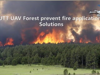
Firefighting drone in forest application
- 2. CATALOG UAV application introduction Application scenarios and requirements Function design System design Products advantages Equipment list 1 2 3 4 5 6
- 3. UAV forest industry application introduction In recent years, environmental changes are large, frequent natural disasters, to the survival of the natural environment has caused a great impact, and caused significant economic losses. For example, forest fires are one of them, to a certain extent affect people's living environment, air quality, the development of logging, and soil erosion, river pollution and so on. Forest fire on the destruction of forest resources and ecological environment caused by the loss is difficult to estimate, in the forest fire, China's fire brigade is facing a complex task situation, and the limitations of traditional on-site investigation has become increasingly prominent. Therefore, how to apply high-tech means to forest resource monitoring, the effective implementation of fire warning and on-site detection, and quickly and accurately dispose of the disaster has become a major issue in forest fire prevention work.
- 4. UAV application background Historically, Thailand was one of the countries with rich forest resources. At the beginning of the twentieth century, Thailand's forest coverage was as high as 75 per cent, and in 1961 it was reduced to 53 per cent in the first national economic and social development program, 27 per cent in the late 1970s and only 22.8 per cent in 1995 %. Thailand's existing forest area of 1.163 million hm2, of which natural forest area of 111.01 million hm2. Per capita forest area of 0.2hm2. As a result of the reduction in forest resources, Thailand has changed from the timber exporting countries of the 1960s to the present timber importing countries. Moreover, imports of wood and other forest products are increasing. With the development of UAV technology, UAV technology will be applied to forest fire, the advantage is more and more obvious, you can carry different task load in the forest patrol, satellite hot spot reconnaissance, fire reconnaissance and so on to play the monitoring function. Compared with the traditional fire, with a flexible, comprehensive vision, feature-rich, safe and reliable features. In the specific application, the UAV can quickly locate the fire point, determine the fire, the fire can provide the best evacuation path. UAV with reliable performance Flight control, GPS positioning, data logging, digital radio communication systems, ground control systems, mounting equipment In addition to conventional airborne loudspeakers, high-definition cameras, tear gas, UAV capture network, life buoy device, Infrared thermal imaging, strong light searchlight, infrared thermal imaging and other functions, can be equipped with microwave, 3G / 4G and other transmission equipment, to achieve analog or digital high-definition image transmission, and the existing public security command system and effective network connection Long command of the new “God eye".
- 5. Application scenarios and requirements • Forest patrol. Real-time patrols can be used to understand the changes in forest environment, logging conditions, plant growth, animal distribution, disaster center, address changes, water changes, and air quality. Can provide real-time video data records, the forest long-term protection, supervision, management and so on. • Detection UAV can be through the video transmission of certain areas of forest reconnaissance, detection to protect the forest natural resources. But also to grasp the rare species, plant production trends change. • Environmental surveillance UAVs can monitor serious areas of forest disasters, observe plant growth rate, soil nutrients, water minerals and other elements. Can be set up UAV route planning, pointing flight, the regular monitoring of regional forests, so as to effectively forest management and protection. • Species protection With the environment, time and space changes, the natural food chain is constantly changing. This affects the survival and continuation of various species in nature, especially in recent years, the global greenhouse effect, many ancient species almost extinct, it will be a major loss of mankind.
- 6. • Fire disaster rescue Due to the wide forest area, the time and space for manual patrols are limited, and the criminals have over-exploited and damaged the forests for private gain. Such as logging, hunting animals, mining, quarrying and so on. The most serious is the illegal elements in order to burn the forest, the fire spread can not control the entire forest burned, which to the country's natural resources has brought serious harm, but also the whole environment has a great impact. Especially as the ambient temperature increases, dust, haze and other natural disasters are caused by the destruction of nature green. • Plant protection In recent years, many countries in order to plant trees in the destruction of economic trees, due to the large area of plant protection and management is not enough, resulting in waste of land resources, plant growth is too slow and affect the expected output of cash crops. UAV can be real- time for plant growth posture, growth rate, growth trends, effective protection. • Meteorological detection UAV can detect air components in high altitude, detect humidity, prevent fire, can effectively manage forest weather. Emergency can help forest management reduce landslides, debris flows, earthquakes and other disasters.
- 7. Forest patrol UAV can be mounted HD zoom camera through the GPS remote control will be aerial video through the wireless map to the designated forest management center, to provide real forest patrol data. Can save labor costs and patrol time. The most important thing can be patrolled at the designated location, convenient and quick to complete the search and surveillance. Application scenarios
- 8. Detection Unmanned aerial vehicles can be real-time monitoring of forest natural changes, plant updates, animal activities, ecological protection
- 9. Environmental monitoring UAV can plan for the forest environment, route monitoring, reconnaissance, patrol. To prevent illegal elements from exploitation of forest resources, destruction of forest face, pollution of the environment, hunting animals, mining minerals, pollution of water.
- 10. Animals protection UAVs can be used for animal protection in the hunting season for forests and animals. To prevent hunters from hunting rare animals.
- 11. Plant protection UAV can be observed for species growth, regularity, growth environment, soil composition, branch characteristics of observation and management. The growth of the regional plant growth attitude, the growth rate of effective protection..
- 12. Fire trend patrol UAV can be calculated by aerial video probably area of fire, and can grasp the direction of fire spread. Fire officers and soldiers can quickly reach the fire site through the UAV rapid fire disaster relief.
- 13. Fire disaster rescue UAV can spread according to the fire of the forest fire trend, through the installation of voice loudspeakers to organize firefighters to fire, fire. In the rescue which can also protect the safety of fire officers and men, so as to improve the safety of forest fire rescue.
- 14. Forest administrator rescue Forest accident fires, forest managers working out, UAVs can protect forest administrators' facilities, personnel, and day-to-day work.
- 15. Meteorological detection UAV can be real-time monitoring of weather, the forest climate change, air humidity, atmospheric pressure detection, to prevent the occurrence of fire Dry Wet
- 16. How to take the uav fire rescue?
- 17. Command and dispatch Mine company office) 20 KM 8 KM A A B C D Operator
- 18. Process of application JTT T60 in Forest ★ Lock surveillance forest range. ★ Ensure photography coordinate. ★ Route planning design. ★ Control site placement. ★ Images data processing.
- 19. System design ◄ Architecture design. Unmanned aerial vehicles after receiving the task, can take off quickly in the first time, quickly arrived at the scene, carrying high sensitivity camera can be uninterrupted picture capture, access to image data, and access to information and images back to the ground. While the real-time live video back to the back-end monitoring center, transmission commanders to make scientific decisions and judgments. The system architecture is as follows: UAV operators can use the remote control to control the UAV in the visual distance within t he implementation of the mission, beyond the line of sight distance can be set through the ground station UAV automatic flight path and preview real-time video. One-button operation function, so that non-professionals after a short training can be skilled to operate UAV. Using digital microwave map transmission and digital frequency hopping transmission technology, compared to ordinary UAV has a longer image transmission and control distance to meet the mobility, beyond the monitoring needs.The back-office commander can view the real-time video of UAVs directly from the ground station, and can also remotely download the images taken by the UAV to the command center for 3 / 4G network and cable network for the scientific decision-making and judgment.
- 20. System design T60 T60Pro Ground control station HD Video transmitter Signal receiver Remote controller
- 21. System function design Aircraft : • ★Aircraft body:6 rotor power support,folding arm,folding propellers,Operation is portable and efficient Diagonal wheelbase:1100mm/1200mm • ★Max. take-off weight:10Kg/15.2KG • Max. payload capacity :2.5Kg/ 3.5kG/ 4.5KG • ★Max. flight time:45min/60min • Flight radius:8km; • Flight altitude:5000m; • Max. flight speed:18m/s • Wind resistant :6 level • GPS module:GPS/GLONASS dual module • Hover accuracy: vertical +/- 20 cm horizontal +/- 0.5 m • Airborne function module quick / quick release design, compatible with a variety of functional modules at the same time operations or exchange, to enhance the use of convenienceSupport the high temperature safety avoidance system, the flight environment temperature exceeds the safety preset temperature, the aircraft to avoid high temperature; low temperature warning function, the flight environment temperature is lower than the set minimum temperature, the aircraft low temperature tips to ensure the safety of the aircraft operation (optional function)★Flying environment Real-time temperature measurement (optional) Battery:20000mAh 6S / 22000mAh 12s/ • Flight mode switching: manual flight mode, satellite mode (hover), route flight mode • Operating temperature (with battery) :-20~60°C;
- 22. • Waterproof design, suitable for sunny, rain or snow and other weather in the air operation.Black box function: with flight recorder: record the flight flight attitude, track, height, power and other informationSafe design: remote control signal interruption automatic return, low power alarm, automatic landing, autonomous hover, route planning, head towards the lock function, real-time return aircraft attitude, coordinates, speed, angle information, power and other information, Features;With the expansion of thermal imaging, photoelectric pod, air propaganda, gas detector, high temperature safe avoidance system, real-time temperature measurement, logistics box, searchlight, throwing device, tilt photography, capture network guns and other management module functions Payload device; 1、High definition camera Three-axis stability drone gimbal, 30x optical zoom lens, 14 million high-definition lens, 200 meters to see the license plate, support AV analog output / HDMI high-definition output, 1080P video, support SD card storage. 2. Thermal imager Intelligent pan / tilt, 336 * 256/640 * 512 resolution, no temperature, USB power supply, analog video output, SD card storage . 3、 Drone capture network With the remote visual targeting system, in tracking the suspects from the air when the capture network, to achieve the crime of people flying over the angle of the network to arrest, to avoid the handling of personnel close to the weapon of the lawless elements to ensure the safety of investigator 4、 Drop medicine platform Can be mounted 3-4KG, controlled by the steering gear on and off, the steering gear from the remote control a channel control, for the surface rescue needs, you can remotely send medicine (people need rescue in fire), the use of airborne image transmission targeting system will life buoy Accurate projection to the rescue target. 5、High lighting searchlight Rescuer was lost contact in fire, the drone can payload searchlight to search where is the people.
- 23. System features and advantage • Function introduction: • • ★With bright LCD dual-screen structure design, map transmission images, flight data at the same time display • Support the same frequency network and 4G public network equipment will be common access to the command center management; • Integrated design, easy to carry, can achieve rapid deployment; • The use of high power transceiver antenna system, receiving high sensitivity, wide coverage, good image quality, small delay • Real-time receiving 1080P HD video, no continuous mosaic, pause, dropped frames, with good color reproduction effect; • Can be based on Google Maps or other GIS data planning for automatic driving of the 3D route and air way mission, air way mission, including the scene shooting, the central point of shooting and vertical remote shooting mode; • Autonomous flight positioning accuracy level <± 1m, vertical <± 0.5m;With multiple data output interface (USB × 2, HDMI × 1);With the autonomy takeoff and landing, autonomous hover, route flight, real-time return aircraft attitude, coordinates, speed, angle information, power and other information; • ★Physical key: lock / unlock, take-off, automatic route, return, landing, throwing, camera / camera, zoom, gimbal rocker, aircraft and airborne mission module for quick and effective control;Bad signal, the battery power can be real-time alarm; • Two-way transmission radio, a variety of digital radio to choose (0.5W ~ 2W), the maximum transmission distance of 10 km; • Real-time video display and storage, real-time modification of flight control variables, map management, route planning, track display, design routes, real-time switching routes, embedded electronic maps, track playback and other functions. With 999 waypoint function.
- 24. • Technology specification: • Screen part: • Software operation monitor: 10.4 inch bright LCD displayImage Receiver Monitor: 10.4 inch bright LCD displaySingle screen size: 10.4 inches, resolution: 1024 × 768★Brightness: ≥ 1000 nits, visible under the sun Data transfer section • Image receiving station:333 MHz ~900 MHzPower Manager: Provides 24V, 12V, 5V multiple power outputImage Receiving Antenna: Large Absorber AntennaData transmission antenna: whip antenna • ★lmage transmission distance:≥10KMModulation mode:COFDMTransmission power of the transmitter:800MW Video transmission port:HDMI • End-to-end delay:≤40msVideo transmission resolution:1080P、1080i、720P、576i Video transmitter channel rate:≥8Mbps. • System function design • Mission planning set up The ground station software can be installed in the mobile terminal, the mobile terminal through WIFI or wired way to connect to the ground station, the UAV flight path and flight path can be set. At the same time, UAV flight location and current flight parameters will be displayed in real time on the ground station software. Return solution UAV can return correctly, related to the UAV flight safety. In addition to the system has a custom return point set, but also need to have a smart return mode. • Return waypoint set up At the time of takeoff, if the GPS signal reaches 6 and above for the first time, it will automatically record the departure position of the UAV as the return point. In the course of flight can also be modified through the ground station software return point location.
- 25. Return mode 1) Out of control return: When the GPS signal is good, the compass is working properly, and the successful record of the return point, such as the ground station control signal is interrupted, no chance to hang in the air for 10 seconds, if 10 seconds or no control signal received, no chance to fly back to return point. During the return process, the wireless signal returns to normal, the return process will continue, the user can control the flight through the remote control, and can cancel the return. 2) Auto return: • After the UAV has completed the mission or the task has been suspended, you can control the UAV automatically return to the return point through the ground station software and complete the landing. 3) Intelligent low battery return: • According to the flight position information, intelligent to determine whether the current power is sufficient. If the current power is less than 30%, no one will automatically return, the return process can not be canceled. The flight can be controlled by the remote control during return and descent. System Features and Benefits • UAV system itself has a mobile fast, low cost, easy maintenance and other technical features, by carrying a different task load can be achieved with the same man-machine monitoring function, and no personnel safety risks, and the landing site And meteorological conditions are low, in the low visibility (such as smoke, night, etc.) in the case of the implementation of the task, in particular, can penetrate the serious danger zone, without manual participation to ensure the safety of personnel. 6.1 system technical characteristics 1) High security: JTT UAV using intelligent flight control system, unmanned aerial vehicles and ground stations using digital frequency hopping radio, reliability and high security.
- 26. • 2) Superior performance: the maximum speed can reach 80km / h, faster than the vast majority of manufacturers of unmanned aerial vehicles, the use of professional map transmission device, combat radius of up to 20 km. The aircraft payload device flight time up to 50 minutes • 3) Drone gimbal features: HD camera; H.264 1080p HD; the drone gimbal independent posture measurement sensor; support three dimensions of the motor; rotation, pitch, roll; the 3 axis drone gimbal self-stability; support drone gimbal follow or direction lock; • 4) Video Stabilization: The built-in attitude measurement sensor can keep the aircraft and pan / tilt in the air stance stable. At the same time, the drone gimbal self-stabilizing system can guarantee the stability of the image. • 5). Features: digital microwave transmission, diffraction ability, in the mountains can not be seen and the occlusion of the viewing, image stable transmission, depending on the situation stable transmission of 10 km; with high-speed mobile wireless transmission capacity, support fixed point and Mobile, mobile and mobile points between the wireless transmission. • 6) The system has intelligent and autonomous flight capability, can be a one-click independent take-off, autonomous hover, autonomous flight, autonomous landing, simple operation, easy to use, to avoid the complex technical training.7) The system has a variety of functions (air propaganda, tear gas, capture network, life buoy device, light searchlight, infrared thermal imaging,)
- 27. System application advantages • 1) Fast emergency response capability: UAV aviation remote sensing system is small, light weight, easy to carry, when there are emergency tasks can quickly reach the target monitoring area. And the system is simple to operate, the preparation time is short, you can quickly start a short period of time, rapid launch, rapid flight, rapid imaging, equipped with high-precision equipment in a short time to obtain monitoring results to achieve remote sensing data quickly. • 2) Strong operational capability in emergency situations: disaster detection and assessment and rescue command in the hazardous area, personnel often can not reach or can not go to the target area, then the UAV aeronautical remote sensing system can show its unique advantages. • 3) can be obtained under the clouds data: UAV remote sensing system can fly under the clouds, make up for satellite optical remote sensing and ordinary manned aerial remote sensing clouds can not access the image of the defects. • 4) Security operations support: UAV remote sensing system using autonomous and ground remote control operations, the implementation of aviation remote sensing tasks, to avoid the flight personnel safety risks. • 5) low cost of image acquisition: UAV system acquisition, operating costs are much lower than manned aircraft, its requirements for the venue and personnel than manned aircraft is low, and routine maintenance is simple, so that access to remote sensing data reduce.
- 28. 6 rotor UAV system Drone body Maximum takeoff weight: 10Kg / 15Kg ,load weight: 3Kg / 4.5kg Maximum flight tim 45min / 60min, high-definition video transmission distance: 5-20km, horizontal flig speed: 18 m / s, wind resistance: 6, configuration includes: body 1, arm 6, landing gear 1Set, 6 motors, 6 electric, 6 propellers Professional flight controller Intelligent direction control, out of control protection, low voltage alarm, automatic return Data transmitter Data transmission system: power, flight height, status data display, flight data and s on Remote controller Control aircraft flight direction and attitude, speed, takeoff and landing and PTZ camera control Battery 22.2V 22000mAh 25C Charger Efficient high-power balanced charging Packing case Maintenance kit and so on Aviation aluminum box Customization Payload device option HD Zoom camera 20x,30x optical zoom lens, 14 million high-definition lens, 8000 meters to see the license plate Thermal imager 336 * 256 640 * 512 resolution, no temperature measurement, USB power supply, analog video output Remote control loud speaker Air propaganda distance:100-200 Meter Ground control station Video transmission module HD image visual distance of 5-20 km; image clarity: 1080P 60fps Figure the host ground station Data records: power, flight height, status data display, flight data playback, missing position. 2, to receive the host-side launch module of the map data, real-time high definition screen transmission real-time monitoring UAV image display.
- 29. Figure the host ground station Data records: power, flight height, status data display, flight data playback, missing position. 2, to receive the host-side launch module of the map data, real- time high-definition screen transmission real-time monitoring UAV image display. 1 Set Sucker antenna Enhance the received signal 1 pcs Installation fee Door to door service 1 Tim e Train charges Shenzhen headquarters training free, home travel expenses 1 Yea r
- 30. THANK YOU ! • Thank you for review JTT UAV Prevent fire application solutions! • Shenzhen JTT Technology co.,Ltd. • Website: www.jttuav.com • Tell: 86-755-86968648 • Mobile: 86-13798214401 • E-mail: sdos13@jttuav.com • Contact: Mr. James Jiang • Address: 6F,A5 Building,Nanshan i Park, No.1001 Xueyuan Avenue,Nanshan District, Shenzhen, Guangdong P.R.C