SlideShare une entreprise Scribd logo
1  sur  7
SUS-410 Conservation Biology
Field Laboratory- Lost Man Reservoir & Independence Ghost Town- September 6, 2013
Field Report-Ancient Wetlands of the Rocky Mountains- September 16, 2013
Jason E Evitt
Site 1: Lost Man Reservoir Fen
I. Site Characterization
A. Habitat Description:
Geomorphic
Land Form
Glaciated mountain slope
Topographic
Position
Basin floor
Aspect SW
Slope 1-2% Gentle
Slope Shape Flat or Concave
Light Exposure The valley is steep and blocks a lot of morning sun with more evening
sun available. There is some micro shading involved with some
evergreen trees about 20-30’ high on the edges of the fen. The light
poles would create small amounts of shade throughout the day as well.
Moisture Inundated with a little surface water present
Proximity to
Moisture
Adjacent to or covered by significant snow for much of the year
Soil Texture 0-5”: mostly organic soil with little mineralization; 5”+: Peat- to a depth
of over 40”
B. Fen Characterization:
1. Dominant Plant Community- Sedge dominated, rushes, mosses, grasses, plane leaf
willow with some willow carr on mossy rises.
2. Soil/Peat Characterization- Soil presence from 0-5” is mostly organic composition with
little mineralization.
a.) Von Post Value- H3: Very little decomposition; very slightly muddy peat;
water squeezed from peat is muddy; no peat passes through fingers when
squeezed; residue retains structure of peat
b.) Peat Depth- Beginning at 5”, peat is persistent to a depth of over 40” to an
undetermined depth.
3. Water Quality- Temperature:
Conductivity:
pH:
4. Water Source-
a.) Groundwater: There is groundwater recharge from the mountains on the
Southwest and West side of the fen. The majority of the groundwater recharge
from the mountains on the North to the Eastern side of the fen is blocked by a
barrier that was created in the 1950’s or 1960’s to collect that water and divert it
to a ditch to carry it to the Front Range via an aqua duct. There is limited
recharge from the dam that is upstream from the fen. The stream offers some
groundwater recharge as well.
b.) There was no apparent outflow of the stream.
c.) There was no apparent surface water inflow to the stream.
d.) There was no surface water domination and very little surface water present.
e.) There may have been impoundment when Highway 82 was created, but that
affect has been visually masked through the many years of adaptation. There are
trails around much of the area that may contribute to impoundment.
f.) In a slopping manner, the topography of the fen area is lower than the
surrounding area. The stream cut on the lower SW side of the fen reveals the
water table being at a consistent grade throughout the fen.
5. Water Development- There is a reservoir about 60 yards away on the Northern,
upstream side of the fen. It does impede water from the fen, but there may be
groundwater recharge from this area as well.
6. Hydrologic Alteration- There is a power line that runs through the middle of the fen.
The 3 or 4 light poles are an intrusion into the fen, but may not pose any hydrologic
alteration.
II. Assessment & Analysis
The fen at the lost man area is functional at this time, but it is not sustainable. Over time,
the mineralization from the trails and NE barrier for water diversion will overtake the
structure of the fen and cause the complexity to be below the 60% peat requirement. The
mineralization would solidify the structure and prevent water infiltration in those areas.
It would also alter the pH of the rest of the system, which would affect the microbial
activity and plant distribution. There is some mineralization that has encroached on the
Eastern side of the fen. It is migrating from the barricade/trail that is above the fen on
that side.
The age of the fen is around 10,000 years old as a fen grows only a few inches per
thousand years and there are over 40 inches of peat present. It most likely began its
development after the recession of the last ice age around 12,000 years ago.
There is a diversity of ecosystems on a vertical scale present. The fen is nestled at the
bottom of the Lost Man Valley. The valley is relatively steep and rises to a distance of
just over 12,000 feet. The vertical rise from the valley floor is around 2,000 feet. This is
a second growth forest with succession nearing maturity in the culmination of primary
spruce/fir forest. There is a montage of Spruce/Fir, Aspen, willow carr, Engelmann
Spruce, Lodge pole Pine, open meadow, wet meadow, and fell field comprising the
surrounding ecosystem. Succession is taking place in the aspen groves, as they are a
secondary forest, giving way to the primary Spruce/Fir forest.
There are no noxious weeds evident in the fen. There are some oxeye daisies and
dandelions growing around the parking lot, which is about 50 yards from the bottom of
the fen. In time, these plants will invade the fen and affect the plant diversity and
distribution of the fen adversely.
There is enough vegetation on the fen to prevent drying out due to wind. The plant
community is intact with a medium average density of around 75-80%. The vegetation
insulates and protects the fen from wind, rain droplets, evaporation and weed seed
invasion. The thatch layer was present and intact. This also provides a layer of
protection and an environment capable of hosting flora and fauna beneficial to the fen.
III. Discussion
Livestock grazing allotments were established in 1905 with the creation of forest
reserves. The specific area where the fen is located, the Hunter/Midvalley allotment, has
not been used since 1966 (Condon). There were probably disturbances and grazing
impacts to the fen, but the area shows no indication of overgrazing at this time from
livestock or wild ungulates.
There was mining in the area during the late 1800’s, but no evidence in the immediate
area of the fen.
There is a need to remove the trail and water diversion ditch above the fen. The
mineralization that is creeping into the fen from those manmade alterations of the
ecosystem poses a threat to the sustainability of the fen. A broader vision to accomplish
this would be to purchase the water rights from the present owners of the Front Range,
which is why the water is being diverted. At that time, removal of the trail and ditch
would be legally feasible. There would be little impact to the recreational use of the area
because there is another trail entering the area that is below the fen. A trail below a fen
does not present a problem of mineralization for the fen.
The Lost Man Reservoir that is above the fen needs to be resolved and removed as well.
Further research needs to be done about that possibility. The reservoir adversely affects
the fen by preventing the water in the reservoir from recharging the groundwater and
becoming available to the fen. The stream channel path is altered because of the location
of the reservoir. There could have been a fen where the reservoir was created, but we do
not know that yet.
Fens are very important for the health of the mountain ecosystem and we need to protect
it as such. Fens hold a large amount of water and slowly release it throughout the season.
The hydrologic cycle is the foundation of any ecosystem because of its importance for the
survival of living organism. It takes thousands of years for a fen to develop, but human
alteration can destroy the functionality of a fen in moments through water diversion,
water drainage systems, peat harvesting or any disturbance that reduces the water table
and exposes the peat to aeration. The water source for a fen comes from groundwater
that is supplied by water moving through the mountains and resurfaces again on the
valley floor. The accumulation of organic material from vegetation along with the cold
temperatures of the ground water and the cold ambient air most of the year (deep snow on
top keeps most of the fen from freezing in the winter) creates an anaerobic condition.
The organic matter decomposes slowly and forms peat. Peat is great at carbon
sequestration and holds lots of water, but not many nutrients. The nutrients that are
characteristically high in quantity in fens come from the groundwater cycling through the
mountains and dissolving minerals and carrying nutrients as it goes. Many nutrients are
slowly dispersed back into the ecosystem via interrelationships of fens.
With their water holding capacity and their high nutrient content, fens are a vital part of
the Rocky Mountain ecosystem. There are an estimated 15,000 acres of fens in 5,544
possible sites in the White River National Forest. Fens help to purify water and harbor
native plants, some of which date back to the last Ice Age. A functional fen can act like a
glacial ice core by containing a climatological record of plants, pollen and insects
(McGregor). Every effort should be made to retain this valuable, vital part of the Rocky
Mountain ecosystem.
Site 2: Independence Ghost Town
I. Site Characterization
A. Habitat Description:
Geomorphic Land
Form
Glaciated mountain slope
Topographic Position Basin floor
Aspect SW 250-270 degrees
Slope 7% Gentle
Slope Shape Flat or Concave
Light Exposure Open, patchy distribution with rock outcrops and open meadows,
grass and flowers
Moisture Inundated with a little surface water present
Proximity to
Moisture
Adjacent to or covered by significant snow for much of the year
Soil Texture 0-8”- Silt/Clay/Organic
8-12”- Peat
12”+ - Peat and Mineral
B. Fen Characterization:
1. Dominant Plant Community- Sedge dominated, rushes, mosses, grasses, plane leaf
willow with some willow carr on mossy rises.
2. Soil/Peat Characterization- Soil presence from 0-8” is a silt/clay/organic composition
a.) Von Post Value- H4: Poorly decomposed; somewhat muddy peat; water
squeezed from peat is muddy; residue is muddy but it shows structure of peat
b.) Peat Depth- Beginning at 8” peat is persistent to a depth of over 40”; at a depth
of 12” peat is accompanied with mineralization to an undetermined depth.
3. Water Quality- Temperature:
Conductivity:
pH:
4. Water Source- Groundwater: The inflow is subsurface. The outflow is subsurface but
there is a small amount of surface flow due to the lack of vegetation.
5. Hydrologic Alteration- Highway 82 crosses the Western slope of the mountain and
alters the hydrologic flow of the groundwater and mineralizes some of it and prevents
some water from reaching the Roaring Fork River which provides recharge of the fen.
II. Assessment & Analysis
This fen is losing its function and is not sustainable under the disruption pressures its
under. Overgrazing by elk is causing extensive damage to the fen in loss of vegetation
and impaction. This also causes mineralization of the subsurface layers.
The large elk population is causing an adverse effect on the fen. Without the wolf as an
apex predator the elk spend too much time in the lowlands and have caused disruption of
the fen. I propose reintroducing the wolf into the ecosystem to regain the needed
predator/prey relationship (Beschta).
I also propose releasing more beavers into the ecosystem to create more wetlands and
prevent erosion. Wetlands are a key component of a healthy ecosystem and they
recharge the aquifers that feed and maintain fens.
III. Discussion
See above discussion.
Citations:
Beschta, Robert L., and William J. Ripple. 2010. "Recovering Riparian Plant
Communities with Wolves in Northern Yellowstone, U.S.A." Restoration
Ecology 18, no. 3: 380-389. Academic Search Complete, EBSCOhost (accessed
September 19, 2013).
Condon, Scott. 28 July 2003. "Sign of Changing Times: Hikers Now Roam Where Sheep
Once Grazed." Aspen Times. N.p., Web. 19 Sept. 2013.
<http://www.aspentimes.com/article/20030728/NEWS/307270004>.
McGregor, Heather. 18 Sept. 2011. "Forest Fins Foster Ice Age Relic Plants." Post
Independent. N.p.,. Web. 19 Sept. 2013.
<http://www.aspentimes.com/article/20110918/NEWS/110919851>.

Contenu connexe

Tendances

Methods to control soil erosion and water run off
Methods to control soil erosion and water run offMethods to control soil erosion and water run off
Methods to control soil erosion and water run offRajat Sharma
 
Developing Australia's Tropical Water Resources
Developing Australia's Tropical Water ResourcesDeveloping Australia's Tropical Water Resources
Developing Australia's Tropical Water ResourceseWater
 
18. soil erosion ans soil conservation by Allah dad khan
18. soil erosion ans soil conservation by Allah dad khan 18. soil erosion ans soil conservation by Allah dad khan
18. soil erosion ans soil conservation by Allah dad khan Mr.Allah Dad Khan
 
Fresh Water Notes (New Text)
Fresh Water Notes (New Text)Fresh Water Notes (New Text)
Fresh Water Notes (New Text)charsh
 
Effects_of_landfill_dumpings_on_comosun_bog_hannah_crisp
Effects_of_landfill_dumpings_on_comosun_bog_hannah_crispEffects_of_landfill_dumpings_on_comosun_bog_hannah_crisp
Effects_of_landfill_dumpings_on_comosun_bog_hannah_crispHannah Crisp
 
Yellowstone pppppppppp ppppppppppp
Yellowstone pppppppppp pppppppppppYellowstone pppppppppp ppppppppppp
Yellowstone pppppppppp pppppppppppcarolzinhaveloso
 
Water management practices
Water management practices Water management practices
Water management practices JAISONPS1
 
Red millpond506 2016_03_23
Red millpond506 2016_03_23Red millpond506 2016_03_23
Red millpond506 2016_03_23Sea Grant
 
interactions among living things in estuary
interactions among living things in estuary interactions among living things in estuary
interactions among living things in estuary Gabriel Mavis
 
Five classification of an estuarine ecosystem
Five classification of an estuarine ecosystemFive classification of an estuarine ecosystem
Five classification of an estuarine ecosystemMark Celoza
 

Tendances (18)

Methods to control soil erosion and water run off
Methods to control soil erosion and water run offMethods to control soil erosion and water run off
Methods to control soil erosion and water run off
 
Bogs
BogsBogs
Bogs
 
467 age 505 lecture on ppp
467 age 505 lecture on ppp467 age 505 lecture on ppp
467 age 505 lecture on ppp
 
Developing Australia's Tropical Water Resources
Developing Australia's Tropical Water ResourcesDeveloping Australia's Tropical Water Resources
Developing Australia's Tropical Water Resources
 
salt marshes
salt marshessalt marshes
salt marshes
 
Sea grasses
Sea grassesSea grasses
Sea grasses
 
Chapter 11 13
Chapter 11 13Chapter 11 13
Chapter 11 13
 
18. soil erosion ans soil conservation by Allah dad khan
18. soil erosion ans soil conservation by Allah dad khan 18. soil erosion ans soil conservation by Allah dad khan
18. soil erosion ans soil conservation by Allah dad khan
 
Fresh Water Notes (New Text)
Fresh Water Notes (New Text)Fresh Water Notes (New Text)
Fresh Water Notes (New Text)
 
Estuaries
EstuariesEstuaries
Estuaries
 
Land use
Land useLand use
Land use
 
Effects_of_landfill_dumpings_on_comosun_bog_hannah_crisp
Effects_of_landfill_dumpings_on_comosun_bog_hannah_crispEffects_of_landfill_dumpings_on_comosun_bog_hannah_crisp
Effects_of_landfill_dumpings_on_comosun_bog_hannah_crisp
 
Yellowstone pppppppppp ppppppppppp
Yellowstone pppppppppp pppppppppppYellowstone pppppppppp ppppppppppp
Yellowstone pppppppppp ppppppppppp
 
Water management practices
Water management practices Water management practices
Water management practices
 
Red millpond506 2016_03_23
Red millpond506 2016_03_23Red millpond506 2016_03_23
Red millpond506 2016_03_23
 
Estuaries as marine ecosytems
Estuaries as  marine  ecosytemsEstuaries as  marine  ecosytems
Estuaries as marine ecosytems
 
interactions among living things in estuary
interactions among living things in estuary interactions among living things in estuary
interactions among living things in estuary
 
Five classification of an estuarine ecosystem
Five classification of an estuarine ecosystemFive classification of an estuarine ecosystem
Five classification of an estuarine ecosystem
 

Similaire à Field Report 1-Ancient Wetlands of the Rocky Mountains

Reportinscience bautista-regala
Reportinscience bautista-regala Reportinscience bautista-regala
Reportinscience bautista-regala tracybautista2
 
WATER AND SOIL RESOURCES.pptx
WATER AND SOIL RESOURCES.pptxWATER AND SOIL RESOURCES.pptx
WATER AND SOIL RESOURCES.pptxAbigailPanes1
 
PHYSICAL GEOGRAPHY 1.4-WATER MASSES
PHYSICAL GEOGRAPHY 1.4-WATER MASSESPHYSICAL GEOGRAPHY 1.4-WATER MASSES
PHYSICAL GEOGRAPHY 1.4-WATER MASSESshahzadebaujiti
 
Restoration Techniques on the Rio Mora National Wildlife Refuge and Surroundi...
Restoration Techniques on the Rio Mora National Wildlife Refuge and Surroundi...Restoration Techniques on the Rio Mora National Wildlife Refuge and Surroundi...
Restoration Techniques on the Rio Mora National Wildlife Refuge and Surroundi...RewildingInstitute
 
Wetland Ecosystem : Field Report Okhla Bird Sanctuary
Wetland Ecosystem : Field Report Okhla Bird SanctuaryWetland Ecosystem : Field Report Okhla Bird Sanctuary
Wetland Ecosystem : Field Report Okhla Bird SanctuaryVikram Aditya
 
Online assignment
Online assignmentOnline assignment
Online assignmentvarshapv27
 
9 - Norfolk Broads (Tessa)
9 - Norfolk Broads (Tessa)9 - Norfolk Broads (Tessa)
9 - Norfolk Broads (Tessa)Ecumene
 
Red mill pond section 506
Red mill pond section 506Red mill pond section 506
Red mill pond section 506Jen S
 
Eath sci (compuesto, dimabayao)
Eath sci (compuesto, dimabayao)Eath sci (compuesto, dimabayao)
Eath sci (compuesto, dimabayao)nicoledimabayao
 
Chapter 4 Water Resource
Chapter 4 Water Resource Chapter 4 Water Resource
Chapter 4 Water Resource Lovely0827
 
The biosphere and animal distribution
The biosphere and animal distributionThe biosphere and animal distribution
The biosphere and animal distributionNirbhay Pimple
 
CHAPTER 4 : WATER RESOURCES
CHAPTER 4 : WATER RESOURCESCHAPTER 4 : WATER RESOURCES
CHAPTER 4 : WATER RESOURCESRamAngeles
 
Gonzales trajico report (chapter4)
Gonzales trajico report (chapter4)Gonzales trajico report (chapter4)
Gonzales trajico report (chapter4)robeerabbit
 
water_resource_management_chapter_4es.ppt
water_resource_management_chapter_4es.pptwater_resource_management_chapter_4es.ppt
water_resource_management_chapter_4es.pptBeaBiancaObniala
 
Freshwater ecology
Freshwater ecology Freshwater ecology
Freshwater ecology Terry Baita
 

Similaire à Field Report 1-Ancient Wetlands of the Rocky Mountains (20)

Ecology of wetlands
Ecology of wetlandsEcology of wetlands
Ecology of wetlands
 
Ch 5 ed
Ch 5 edCh 5 ed
Ch 5 ed
 
Ch 5 ed
Ch 5 edCh 5 ed
Ch 5 ed
 
Reportinscience bautista-regala
Reportinscience bautista-regala Reportinscience bautista-regala
Reportinscience bautista-regala
 
WATER AND SOIL RESOURCES.pptx
WATER AND SOIL RESOURCES.pptxWATER AND SOIL RESOURCES.pptx
WATER AND SOIL RESOURCES.pptx
 
PHYSICAL GEOGRAPHY 1.4-WATER MASSES
PHYSICAL GEOGRAPHY 1.4-WATER MASSESPHYSICAL GEOGRAPHY 1.4-WATER MASSES
PHYSICAL GEOGRAPHY 1.4-WATER MASSES
 
Restoration Techniques on the Rio Mora National Wildlife Refuge and Surroundi...
Restoration Techniques on the Rio Mora National Wildlife Refuge and Surroundi...Restoration Techniques on the Rio Mora National Wildlife Refuge and Surroundi...
Restoration Techniques on the Rio Mora National Wildlife Refuge and Surroundi...
 
Wetland Ecosystem : Field Report Okhla Bird Sanctuary
Wetland Ecosystem : Field Report Okhla Bird SanctuaryWetland Ecosystem : Field Report Okhla Bird Sanctuary
Wetland Ecosystem : Field Report Okhla Bird Sanctuary
 
Online assignment
Online assignmentOnline assignment
Online assignment
 
Lake ecology 2017
Lake ecology 2017Lake ecology 2017
Lake ecology 2017
 
9 - Norfolk Broads (Tessa)
9 - Norfolk Broads (Tessa)9 - Norfolk Broads (Tessa)
9 - Norfolk Broads (Tessa)
 
Red mill pond section 506
Red mill pond section 506Red mill pond section 506
Red mill pond section 506
 
Eath sci (compuesto, dimabayao)
Eath sci (compuesto, dimabayao)Eath sci (compuesto, dimabayao)
Eath sci (compuesto, dimabayao)
 
Chapter 4 Water Resource
Chapter 4 Water Resource Chapter 4 Water Resource
Chapter 4 Water Resource
 
The biosphere and animal distribution
The biosphere and animal distributionThe biosphere and animal distribution
The biosphere and animal distribution
 
CHAPTER 4 : WATER RESOURCES
CHAPTER 4 : WATER RESOURCESCHAPTER 4 : WATER RESOURCES
CHAPTER 4 : WATER RESOURCES
 
Gonzales trajico report (chapter4)
Gonzales trajico report (chapter4)Gonzales trajico report (chapter4)
Gonzales trajico report (chapter4)
 
wetland
wetland wetland
wetland
 
water_resource_management_chapter_4es.ppt
water_resource_management_chapter_4es.pptwater_resource_management_chapter_4es.ppt
water_resource_management_chapter_4es.ppt
 
Freshwater ecology
Freshwater ecology Freshwater ecology
Freshwater ecology
 

Plus de Jason E Evitt

Patterns in a Changing Landscape
Patterns in a Changing LandscapePatterns in a Changing Landscape
Patterns in a Changing LandscapeJason E Evitt
 
Ecopsychology Fosters Sustainable Behavior-Final Paper
Ecopsychology Fosters Sustainable Behavior-Final PaperEcopsychology Fosters Sustainable Behavior-Final Paper
Ecopsychology Fosters Sustainable Behavior-Final PaperJason E Evitt
 
Environmental Justice Presentation
Environmental Justice PresentationEnvironmental Justice Presentation
Environmental Justice PresentationJason E Evitt
 
White Paper 2-Endangered Species Management Plan Assessment-Black-footed Ferr...
White Paper 2-Endangered Species Management Plan Assessment-Black-footed Ferr...White Paper 2-Endangered Species Management Plan Assessment-Black-footed Ferr...
White Paper 2-Endangered Species Management Plan Assessment-Black-footed Ferr...Jason E Evitt
 
Black-footed Ferret Poster
Black-footed Ferret PosterBlack-footed Ferret Poster
Black-footed Ferret PosterJason E Evitt
 
Capstone Project Poster.ppt
Capstone Project Poster.pptCapstone Project Poster.ppt
Capstone Project Poster.pptJason E Evitt
 

Plus de Jason E Evitt (7)

Patterns in a Changing Landscape
Patterns in a Changing LandscapePatterns in a Changing Landscape
Patterns in a Changing Landscape
 
Ecopsychology Fosters Sustainable Behavior-Final Paper
Ecopsychology Fosters Sustainable Behavior-Final PaperEcopsychology Fosters Sustainable Behavior-Final Paper
Ecopsychology Fosters Sustainable Behavior-Final Paper
 
Environmental Justice Presentation
Environmental Justice PresentationEnvironmental Justice Presentation
Environmental Justice Presentation
 
White Paper 2-Endangered Species Management Plan Assessment-Black-footed Ferr...
White Paper 2-Endangered Species Management Plan Assessment-Black-footed Ferr...White Paper 2-Endangered Species Management Plan Assessment-Black-footed Ferr...
White Paper 2-Endangered Species Management Plan Assessment-Black-footed Ferr...
 
Capstone Paper
Capstone PaperCapstone Paper
Capstone Paper
 
Black-footed Ferret Poster
Black-footed Ferret PosterBlack-footed Ferret Poster
Black-footed Ferret Poster
 
Capstone Project Poster.ppt
Capstone Project Poster.pptCapstone Project Poster.ppt
Capstone Project Poster.ppt
 

Field Report 1-Ancient Wetlands of the Rocky Mountains

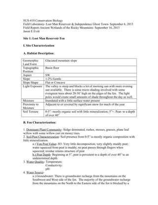
  • 1. SUS-410 Conservation Biology Field Laboratory- Lost Man Reservoir & Independence Ghost Town- September 6, 2013 Field Report-Ancient Wetlands of the Rocky Mountains- September 16, 2013 Jason E Evitt Site 1: Lost Man Reservoir Fen I. Site Characterization A. Habitat Description: Geomorphic Land Form Glaciated mountain slope Topographic Position Basin floor Aspect SW Slope 1-2% Gentle Slope Shape Flat or Concave Light Exposure The valley is steep and blocks a lot of morning sun with more evening sun available. There is some micro shading involved with some evergreen trees about 20-30’ high on the edges of the fen. The light poles would create small amounts of shade throughout the day as well. Moisture Inundated with a little surface water present Proximity to Moisture Adjacent to or covered by significant snow for much of the year Soil Texture 0-5”: mostly organic soil with little mineralization; 5”+: Peat- to a depth of over 40” B. Fen Characterization: 1. Dominant Plant Community- Sedge dominated, rushes, mosses, grasses, plane leaf willow with some willow carr on mossy rises. 2. Soil/Peat Characterization- Soil presence from 0-5” is mostly organic composition with little mineralization. a.) Von Post Value- H3: Very little decomposition; very slightly muddy peat; water squeezed from peat is muddy; no peat passes through fingers when squeezed; residue retains structure of peat b.) Peat Depth- Beginning at 5”, peat is persistent to a depth of over 40” to an undetermined depth. 3. Water Quality- Temperature: Conductivity: pH: 4. Water Source- a.) Groundwater: There is groundwater recharge from the mountains on the Southwest and West side of the fen. The majority of the groundwater recharge from the mountains on the North to the Eastern side of the fen is blocked by a
  • 2. barrier that was created in the 1950’s or 1960’s to collect that water and divert it to a ditch to carry it to the Front Range via an aqua duct. There is limited recharge from the dam that is upstream from the fen. The stream offers some groundwater recharge as well. b.) There was no apparent outflow of the stream. c.) There was no apparent surface water inflow to the stream. d.) There was no surface water domination and very little surface water present. e.) There may have been impoundment when Highway 82 was created, but that affect has been visually masked through the many years of adaptation. There are trails around much of the area that may contribute to impoundment. f.) In a slopping manner, the topography of the fen area is lower than the surrounding area. The stream cut on the lower SW side of the fen reveals the water table being at a consistent grade throughout the fen. 5. Water Development- There is a reservoir about 60 yards away on the Northern, upstream side of the fen. It does impede water from the fen, but there may be groundwater recharge from this area as well. 6. Hydrologic Alteration- There is a power line that runs through the middle of the fen. The 3 or 4 light poles are an intrusion into the fen, but may not pose any hydrologic alteration. II. Assessment & Analysis The fen at the lost man area is functional at this time, but it is not sustainable. Over time, the mineralization from the trails and NE barrier for water diversion will overtake the structure of the fen and cause the complexity to be below the 60% peat requirement. The mineralization would solidify the structure and prevent water infiltration in those areas. It would also alter the pH of the rest of the system, which would affect the microbial activity and plant distribution. There is some mineralization that has encroached on the Eastern side of the fen. It is migrating from the barricade/trail that is above the fen on that side. The age of the fen is around 10,000 years old as a fen grows only a few inches per thousand years and there are over 40 inches of peat present. It most likely began its development after the recession of the last ice age around 12,000 years ago. There is a diversity of ecosystems on a vertical scale present. The fen is nestled at the bottom of the Lost Man Valley. The valley is relatively steep and rises to a distance of just over 12,000 feet. The vertical rise from the valley floor is around 2,000 feet. This is a second growth forest with succession nearing maturity in the culmination of primary
  • 3. spruce/fir forest. There is a montage of Spruce/Fir, Aspen, willow carr, Engelmann Spruce, Lodge pole Pine, open meadow, wet meadow, and fell field comprising the surrounding ecosystem. Succession is taking place in the aspen groves, as they are a secondary forest, giving way to the primary Spruce/Fir forest. There are no noxious weeds evident in the fen. There are some oxeye daisies and dandelions growing around the parking lot, which is about 50 yards from the bottom of the fen. In time, these plants will invade the fen and affect the plant diversity and distribution of the fen adversely. There is enough vegetation on the fen to prevent drying out due to wind. The plant community is intact with a medium average density of around 75-80%. The vegetation insulates and protects the fen from wind, rain droplets, evaporation and weed seed invasion. The thatch layer was present and intact. This also provides a layer of protection and an environment capable of hosting flora and fauna beneficial to the fen. III. Discussion Livestock grazing allotments were established in 1905 with the creation of forest reserves. The specific area where the fen is located, the Hunter/Midvalley allotment, has not been used since 1966 (Condon). There were probably disturbances and grazing impacts to the fen, but the area shows no indication of overgrazing at this time from livestock or wild ungulates. There was mining in the area during the late 1800’s, but no evidence in the immediate area of the fen. There is a need to remove the trail and water diversion ditch above the fen. The mineralization that is creeping into the fen from those manmade alterations of the ecosystem poses a threat to the sustainability of the fen. A broader vision to accomplish this would be to purchase the water rights from the present owners of the Front Range, which is why the water is being diverted. At that time, removal of the trail and ditch would be legally feasible. There would be little impact to the recreational use of the area because there is another trail entering the area that is below the fen. A trail below a fen does not present a problem of mineralization for the fen. The Lost Man Reservoir that is above the fen needs to be resolved and removed as well. Further research needs to be done about that possibility. The reservoir adversely affects the fen by preventing the water in the reservoir from recharging the groundwater and becoming available to the fen. The stream channel path is altered because of the location of the reservoir. There could have been a fen where the reservoir was created, but we do not know that yet. Fens are very important for the health of the mountain ecosystem and we need to protect it as such. Fens hold a large amount of water and slowly release it throughout the season. The hydrologic cycle is the foundation of any ecosystem because of its importance for the
  • 4. survival of living organism. It takes thousands of years for a fen to develop, but human alteration can destroy the functionality of a fen in moments through water diversion, water drainage systems, peat harvesting or any disturbance that reduces the water table and exposes the peat to aeration. The water source for a fen comes from groundwater that is supplied by water moving through the mountains and resurfaces again on the valley floor. The accumulation of organic material from vegetation along with the cold temperatures of the ground water and the cold ambient air most of the year (deep snow on top keeps most of the fen from freezing in the winter) creates an anaerobic condition. The organic matter decomposes slowly and forms peat. Peat is great at carbon sequestration and holds lots of water, but not many nutrients. The nutrients that are characteristically high in quantity in fens come from the groundwater cycling through the mountains and dissolving minerals and carrying nutrients as it goes. Many nutrients are slowly dispersed back into the ecosystem via interrelationships of fens. With their water holding capacity and their high nutrient content, fens are a vital part of the Rocky Mountain ecosystem. There are an estimated 15,000 acres of fens in 5,544 possible sites in the White River National Forest. Fens help to purify water and harbor native plants, some of which date back to the last Ice Age. A functional fen can act like a glacial ice core by containing a climatological record of plants, pollen and insects (McGregor). Every effort should be made to retain this valuable, vital part of the Rocky Mountain ecosystem. Site 2: Independence Ghost Town I. Site Characterization A. Habitat Description: Geomorphic Land Form Glaciated mountain slope Topographic Position Basin floor Aspect SW 250-270 degrees Slope 7% Gentle Slope Shape Flat or Concave Light Exposure Open, patchy distribution with rock outcrops and open meadows, grass and flowers Moisture Inundated with a little surface water present Proximity to Moisture Adjacent to or covered by significant snow for much of the year Soil Texture 0-8”- Silt/Clay/Organic 8-12”- Peat 12”+ - Peat and Mineral B. Fen Characterization:
  • 5. 1. Dominant Plant Community- Sedge dominated, rushes, mosses, grasses, plane leaf willow with some willow carr on mossy rises. 2. Soil/Peat Characterization- Soil presence from 0-8” is a silt/clay/organic composition a.) Von Post Value- H4: Poorly decomposed; somewhat muddy peat; water squeezed from peat is muddy; residue is muddy but it shows structure of peat b.) Peat Depth- Beginning at 8” peat is persistent to a depth of over 40”; at a depth of 12” peat is accompanied with mineralization to an undetermined depth. 3. Water Quality- Temperature: Conductivity: pH: 4. Water Source- Groundwater: The inflow is subsurface. The outflow is subsurface but there is a small amount of surface flow due to the lack of vegetation. 5. Hydrologic Alteration- Highway 82 crosses the Western slope of the mountain and alters the hydrologic flow of the groundwater and mineralizes some of it and prevents some water from reaching the Roaring Fork River which provides recharge of the fen. II. Assessment & Analysis This fen is losing its function and is not sustainable under the disruption pressures its under. Overgrazing by elk is causing extensive damage to the fen in loss of vegetation and impaction. This also causes mineralization of the subsurface layers. The large elk population is causing an adverse effect on the fen. Without the wolf as an apex predator the elk spend too much time in the lowlands and have caused disruption of the fen. I propose reintroducing the wolf into the ecosystem to regain the needed predator/prey relationship (Beschta). I also propose releasing more beavers into the ecosystem to create more wetlands and prevent erosion. Wetlands are a key component of a healthy ecosystem and they recharge the aquifers that feed and maintain fens. III. Discussion See above discussion. Citations:
  • 6. Beschta, Robert L., and William J. Ripple. 2010. "Recovering Riparian Plant Communities with Wolves in Northern Yellowstone, U.S.A." Restoration Ecology 18, no. 3: 380-389. Academic Search Complete, EBSCOhost (accessed September 19, 2013). Condon, Scott. 28 July 2003. "Sign of Changing Times: Hikers Now Roam Where Sheep Once Grazed." Aspen Times. N.p., Web. 19 Sept. 2013. <http://www.aspentimes.com/article/20030728/NEWS/307270004>. McGregor, Heather. 18 Sept. 2011. "Forest Fins Foster Ice Age Relic Plants." Post Independent. N.p.,. Web. 19 Sept. 2013. <http://www.aspentimes.com/article/20110918/NEWS/110919851>.
  • 7. Beschta, Robert L., and William J. Ripple. 2010. "Recovering Riparian Plant Communities with Wolves in Northern Yellowstone, U.S.A." Restoration Ecology 18, no. 3: 380-389. Academic Search Complete, EBSCOhost (accessed September 19, 2013). Condon, Scott. 28 July 2003. "Sign of Changing Times: Hikers Now Roam Where Sheep Once Grazed." Aspen Times. N.p., Web. 19 Sept. 2013. <http://www.aspentimes.com/article/20030728/NEWS/307270004>. McGregor, Heather. 18 Sept. 2011. "Forest Fins Foster Ice Age Relic Plants." Post Independent. N.p.,. Web. 19 Sept. 2013. <http://www.aspentimes.com/article/20110918/NEWS/110919851>.