Major Winter Storm Update Feb 1-2
•
1 j'aime•234 vues

yet another one on the way to hit CT, yay ...
Recommandé

Recommandé
Contenu connexe
En vedette
En vedette (9)
Similaire à Major Winter Storm Update Feb 1-2
Similaire à Major Winter Storm Update Feb 1-2 (20)
Plus de Icahn School of Medicine at Mount Sinai
Plus de Icahn School of Medicine at Mount Sinai (6)
Major Winter Storm Update Feb 1-2
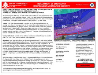
- 1. TUESDAY, May 26, 1999 – 4:15 PM WINTER STORM UPDATE DEPARTMENT OF EMERGENCY Monday January 31, 2011 Peter J. Boynton, Commissioner 2:00 PM MANAGEMENT & HOMELAND SECURITY LONG DURATION DOUBLE BARREL WINTER STORM IS FORECASTED FOR TUESDAY MORNING THROUGH WEDNESDAY NIGHT… SIGNIFICANT RISK OF ROOF & DECK COLLAPSE IS POSSIBLE… The late morning runs of the GFS and NAM models continue to forecast a long duration winter storm Tuesday morning through Wednesday evening. The GFS and NAM models are forecasting a double barrel system with snow and some sleet on Tuesday and a heavy mix of snow, sleet and freezing rain on Wednesday. The following forecast is based on a blend of the GFS and NAM models: Tuesday: Light snow developing between 3:00 – 6:00 AM and becoming steadier during the morning. Some sleet and freezing rain may mix into southern Connecticut by late morning with 3 - 5 inches of snow expected by the afternoon rush hour. The snow is forecast to taper off to light snow by mid-afternoon. Highs in the 20's. Some minor icing on power lines and trees is possible in Southern and Central CT. A minor to moderate impact is expected for the Tuesday morning rush hour with moderate snow falling in Central and Western CT. The impact on travel is expected to be moderate for the Tuesday afternoon rush hour. Tuesday Night: Drizzle overnight with an additional inch of snow, sleet and freezing rain possible. Lows in the 20's. A minor impact on overnight travel is expected. Wednesday: Snow, Sleet and Freezing rain becoming moderate to heavy at times around daybreak STORM TRACK AND SNOWFALL FORECAST FOR TUESDAY & WEDNESDAY and continuing through the day into the late afternoon. The mixed precipitation is expected to change back to snow before ending by late Wednesday evening. Highs in the upper 20's to low 30's. A WATCHES AND WARNINGS This product is a public service of the considerable risk of roof and deck collapses is forecast during the day on Wednesday and continuing Department of Emergency into Thursday morning as the snow, sleet and rain add more weight to roofs and decks. Considerable Winter Storm Watches Management and Homeland icing may also occur causing significant power outages. The outlook for both Wednesday rush hours All of Connecticut Security (DEMHS), and is intended is for a moderate impact on travel in Southern CT with mixed precipitation melting on most treated for informational purposes only. and heavily traveled highways, but sticking to the less traveled and treated secondary roads. A Winter Weather Advisories DEMHS assumes no liability for the moderate to major impact is possible in Northern CT with heavy snow falling, mixed with sleet at None at this time. use or distribution of this product or times. any actions resulting from this Wind Advisories None at this time. product. Storm total snowfall is forecast to range from 3 - 5 inches along the coast up to 15 inches in Northern CT. Approximately 1 inch of sleet and 1/2 - 3/4 inch of icing is also possible during the storm. Flood Watch STATUS OF THE STATE Forecast confidence remains good at this time, however the rain/snow line is going to be fairly narrow None at this time. EMERGENCY OPERATIONS (only 150 miles between all rain and all snow) across Southern New England during the storm. If the CENTER track of the storm moves 50 miles north or south then we can expect the snowfall amounts and icing to shift north or south with the storm track. MONITORING The Department of Emergency Management and Homeland Security will continue to monitor this approaching storm and will issue another update at 8:00 PM.